| Previous :: Next Topic |
| Author |
Message |
moonspots
Happy Curmudgeon


Joined: 03 Feb 2007
Posts: 2456 | TRs | Pics
Location: North Dakota |
|
moonspots
Happy Curmudgeon
|
 Sat Mar 30, 2013 2:57 am |
|
|
| The Angry Hiker wrote: | | The great thing about decommissioned logging roads is that they're relatively easy and inexpensive to turn into hiking trails. |
So back to my first comment/question: after all this gnashing of teeth, has anyone here written to "whoever you write to" and expressed these apparently legitimate concerns and complaints? I've not seen any of these trails (yet), but the argument that AH has presented looks quite reasonable to me.
"Out, OUT you demons of Stupidity"! - St Dogbert, patron Saint of Technology
"Out, OUT you demons of Stupidity"! - St Dogbert, patron Saint of Technology
|
| Back to top |
  
|
|
like2thruhike
Member

Joined: 28 May 2009
Posts: 1288 | TRs | Pics
Location: Seattle |
They just wanted the stuff in the forest to match what you can see from the freeway.
|
| Back to top |
|
|
mtnresqr
Member
Joined: 18 May 2010
Posts: 48 | TRs | Pics
|
|
mtnresqr
Member
|
Sun Mar 31, 2013 10:04 am |
|
|
The "road decommissioning" goes all the way up to the Thompson Lake turn-off. It's now a "trail", totally.
And, if one gets to Thompson Lake outlet, I have found about 30% of the old trail that went farther on down to meet up with the Pratt River trail. It's 1.5 miles down to meet with an old logging RR that went from the Pratt River to junction of Thompson Creek and Spider Creek. That RR is about 1.7 miles long.
|
| Back to top |
|
|
Slugman
Its a Slugfest!

Joined: 27 Mar 2003
Posts: 16874 | TRs | Pics
|
|
Slugman
Its a Slugfest!
|
Sun Mar 31, 2013 3:13 pm |
|
|
In Seattle's Discovery park, they have decommissioned some paved roads, dug up the pavement, and replanted with native vegetation. Then they ran a trail up the old road. But the trail goes more or less right up, with no back and forth across the old road clearing, maybe a couple of little zigs or zags to go around new trees. I am not a fan of artificially making something seem more trail-like, especially when it is such a "fail" as that Boulder lake road. Why can't something just be what it is, a road turned into a trail? Is there perhaps some logic, in that 20 years from now it will be better that they did this now? If so, I don't see it.
|
| Back to top |
|
|
Bedivere
Why Do Witches Burn?

Joined: 25 Jul 2008
Posts: 7464 | TRs | Pics
Location: The Hermitage |
|
Bedivere
Why Do Witches Burn?
|
Sun Mar 31, 2013 11:44 pm |
|
|
| Slugman wrote: | | Is there perhaps some logic, in that 20 years from now it will be better that they did this now? If so, I don't see it. |
Slug - this is the only rationale I can figure:
| Bernardo wrote: | | Curves for style are absurd. Maybe they are erosion control feature. |
someone else mentioned earlier in this thread that water can run down a straight trail or road and scour it out and turn it into a mini-creek.
that can definitely happen, however, looking at the pictures posted of the road before this trail conversion, it doesn't look like it was happening to this road. That road's been there for what, 20+ years? If it was going to have erosion/runoff problems it would've had them by now.
This is a real bummer. Old roads like that are great for mt. biking or for just hauling ass/running on training hikes. I used to ride up to Loch Katrine for kicks back when the road up there was in decent shape and Weyerhauser didn't care.
|
| Back to top |
|
|
tigermn
Member

Joined: 10 Jul 2007
Posts: 9242 | TRs | Pics
Location: There... |
|
tigermn
Member
|
Mon Apr 01, 2013 6:29 am |
|
|
Exactly Willie. Now the road they should have done something about was Dirty Harry's. Why didn't they decommission that one and fix it so it's not a frigging creek? Instead they mess up good walking roads.
|
| Back to top |
|
|
tigermn
Member
Joined: 10 Jul 2007
Posts: 9242 | TRs | Pics
Location: There... |
|
tigermn
Member
|
Sun May 12, 2013 5:08 pm |
|
|
Ok I finally went up there this weekend. While I still maintain they didn't really need to mess with the road that was already there (namely funds could have been better used to repair/improve/create other trails). The trail itself is nice. I don't see what all the complaining is about regarding the actual trail.
Interesting that the higher you go the more the trail resembles the old road whereas down below the road aspect is more hidden/covered up.
The lower creeks have nice stepping stones to cross. Less so as you go higher.
|
| Back to top |
|
|
boot up
Old Not Bold Hiker

Joined: 12 Dec 2006
Posts: 4745 | TRs | Pics
Location: Bend Oregon |
|
boot up
Old Not Bold Hiker
|
Sun May 12, 2013 5:38 pm |
|
|
I agree that it is very weird to be threatening to shut down Mt Si for "lack of funding", under the same agency, while dumping huge amounts of funding and effort on this trail.
Otherwise I strongly disagree. If we don't whine about what a crappy experience this hike is, how else are we going to be able to stroll through such variety and distance on a beautiful day, only seeing 7 other people all day, while a few hundred yards away, the parking is overflowing for knee crunching, brutally steep Mailbox trail?
Yah, it just sucked on Granite Lakes trail.

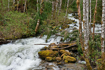 View up Granite creek from new log bridge. Granite Lakes, new trail, WA 05/11/13 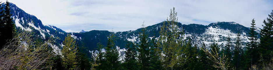 Panorama from Thompson lk trail intersection. Granite Lakes, new trail, WA 05/11/13
|
| Back to top |
|
|
The Angry Hiker
SAR Blacklistee

Joined: 13 Jun 2008
Posts: 2890 | TRs | Pics
Location: Kentwila |
You didn't feel like your intelligence was being insulted? Especially on the lower trail where they corral you like sheep?
|
| Back to top |
|
|
rossb
Member

Joined: 23 Sep 2002
Posts: 1679 | TRs | Pics
|
|
rossb
Member
|
Mon May 13, 2013 10:07 am |
|
|
I think the biggest negative (for me and a few others) is that the change makes it harder to ski or bike. From a ski perspective, if the trail is more straight and wide up above than this change won't hurt things much, since this area starts so low. You are likely to carry your skis for the first mile or so almost year round. This assumes that it is still fairly easy to ski the upper sections (and remains so).
For biking, I'm afraid it is the opposite. You want the lower stretches to be easy, and the upper stretches to be hard (you can always park your bike when the biking gets hard).
It may be that the trail was made "rough" at the bottom to reduce poaching. If they leave the upper part as more road like, then this would make sense. Other possibilities include:
1) The lower section is more likely to become a stream if it is left alone, but the upper section is fine as is.
2) They plan on doing the same thing for the entire road, but just haven't gotten to it yet.
3) They decided to only spend a certain amount of money on this project, so they will only do the first couple miles.
|
| Back to top |
|
|
vtolkov
Member
Joined: 10 May 2009
Posts: 3 | TRs | Pics
|
|
vtolkov
Member
|
Thu Jun 06, 2013 2:56 pm |
|
|
I would like to sign petition as well, but I'm not sure, who is responsible for that. Is it WTA or King County or NFS?
|
| Back to top |
|
|
PeaksAndValleys
Member
Joined: 09 Jul 2010
Posts: 37 | TRs | Pics
|
My girl and I hiked to Thompson just before the snow last fall. I was really surprised at how much harder it was hiking the new "trail" compared to the road. It was sort of maddening following the twisty-turny unnatural flow of the new trail. I always thought of the old road as an easy bike approach to a little visited alpine lake. Biking it will require some work and skill. Definitely not for beginners. Riding DOWN the trail might lead to some collisions (speed limit signs coming soon?)
The faux-trail really is something you experience to believe. There really was some artistry to building it. But all the extra zig-zags and Dizneyland features give it a strange vibe not altogether unlike "shabby chic" furniture sold at Target. Yeah nature will heal the scars and the jungle will grow back. But I agree that this trail will always have an odd plastic feel.
Hey how about that round-about at Thompson-Granite road intersection?
I'd swear the builder intended some sort of suburban irony! Does the round-about anticipate hordes of hipsters and their PBR mini-kegs?
| The Angry Hiker wrote: | | One "Hidden Gem" write-up in the daily rag and Granite Lakes will be suckering them in like Grandma to a Nigerian email scam. |
Yep, take this trip before the minivan stick-family window sticker ankle-biter wranglers hear about it. The trail seems created as a place to send mobs for a "nature experience." Wonder when the PR campaign will begin? Is there special "Go-Car" parking for Belltowners?
The days of solitude up there are soon over.
|
| Back to top |
|
|
flatsqwerl
Member

Joined: 23 Feb 2010
Posts: 1052 | TRs | Pics
Location: tacoma |
nothing that 100 people with shovels, pickaxes and beer can't fix... 
|
| Back to top |
|
|
nuclear_eggset
Member
Joined: 02 Jul 2006
Posts: 2206 | TRs | Pics
Location: Eastside |
| Quote: | | It's not all bad, though. Once you get over the initial nausea, the landscaping is quite amazing. Every stone, stump, and stick seems to have been strategically placed to create an air of authenticity, but the whole hike comes off like a stroll through Thomas Kincade's garden after he went nuts and they found him naked in a tree, biting the heads off of squirrels. |
This made my night!
Thank you!

|
| Back to top |
|
|
PeaksAndValleys
Member
Joined: 09 Jul 2010
Posts: 37 | TRs | Pics
|
REI and the Forest Circus needed another place to send the new residents of South Lake Union. Maybe it'll be renamed the Vulcan Trail?
|
| Back to top |
|
|
|
|


