| Previous :: Next Topic |
| Author |
Message |
whitebark
Member


Joined: 08 Jul 2005
Posts: 1864 | TRs | Pics
Location: Seattle |
On Thursday I spent a few hours exploring some oddball trails in the Ira Spring Th/Exit 42 area. I began my low-key adventure by parking at the Iron Spring trailhead, then following the main trail to the first curve. There I left the Ira Spring trail and headed straight ahead onto the Putrid Peak/Old Defiance Ridge trail, which is unmarked but fairly well used by PPP scramblers. Rangers keep throwing debris onto this trail to hide the trail- seems someone is unhappy about it.
The Old Defiance Ridge trail was in good shape and appears to have been actively constructed by a trail crew. Rumor has it the the work was done by a rogue ranger who was eventually told to stop by his managers, but not before he got partway up Putrid Pete Peak. It would be interesting to find out more about the history of this trail.
I followed the trail all the way to the start of the Balcony Traverse Trail, just beyond a charming little creek that tumbles down the steep slope. The PPP trail here makes a hard right to begin a switchbacking ascent. I continued straight ahead and followed the Balcony trail as it made an up-and down traverse of the slope, crossing a couple of lively snowmelt creeks along the way. The trail eventually flattened out on a deeply wooded plateau, where I made the short side trip to Upper Balcony Vista a quiet, little-visited alternative to Dirty Harry's Balcony.
Then I continued hiking the Balcony trail, which crossed a rockslide then began a rapid and rugged descent (along the way crossing two more snowmelt creeks) to reach the end of an old logging road near to DHB. A short walk along the road led me to an unmarked junction with the DHB trail. Here, not interested in visiting the heavily used DHB, I turned around and headed back the way I came.
My next exploration was to check out the Lower Old Defiance Trail, which splits off the PPP trail about a half mile from the Ira Spring TH. A small sign indicating "I-90 Exit 42" currently marks the junction. This trail was the handiwork of the rogue ranger and is still in remarkably good shape, despite years of neglect. The main users of the trail seem to be elk, but someone in the recent past took the time to cut out the blowdowns. The path descended down the hill in two long switchbacks. Its route was mostly in forest but a rockslide section offered a bit of a view toward McClellan Butte.
At length the trail reached the end of an old overgrown logging road. I followed the road down toward the increasing noise of I-90 and a junction with another road used for a fiber optic cable right of way. This road, which clearly has been getting some use by walkers, took me toward the Exit 42 area.
Just before reaching the Exit 42 road end, I turned off onto the Mason Creek Trail. This pleasant route climbed the hillside in cool forest near the tumbling waters of the creek, and eventually led me back to the main road leading to the Ira Spring Trailhead. A short walk along the road took me back to the main parking area and my car.
All and all, this was a fun little dumpster dive hike on some uncrowded trails.
Here's a crude map of the trails:
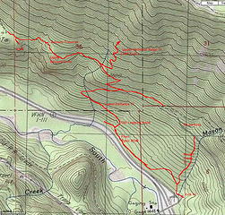 Exit 42 trails
|
| Back to top |
  
|
|
puzzlr
Mid Fork Rocks

Joined: 13 Feb 2007
Posts: 7220 | TRs | Pics
Location: Stuck in the middle |
|
puzzlr
Mid Fork Rocks
|
 Mon May 20, 2013 4:01 pm |
|
|
Very interesting. Thanks for taking the time to write it up.
|
| Back to top |
|
|
Bramble_Scramble
Member
Joined: 28 Dec 2012
Posts: 312 | TRs | Pics
|
I use the trail from 42 following the creek up to the Ira Spring lot quite regularly. You can avoid logging and potholes and packed parking. It does add a bit of elevation gain, but I like to summit West Defiance, Defiance, and Bandera from here because it's a valley floor to summit hike and makes it all the more satisfying.
We just explored the old trail with a new sign for Exit 42 a week ago. We tried finding the trail from the bottom first but couldn't find the cutoff so we ended up coming down the signed junction. Did you see the 5-7 strange sheds lining the trail marked "Explosive?" I'm wondering if these were left here from road building or what.
|
| Back to top |
|
|
whitebark
Member

Joined: 08 Jul 2005
Posts: 1864 | TRs | Pics
Location: Seattle |
Yeah, I saw those explosive sheds - there were a whole bunch of them scattered in the woods. It would be interesting to find out what they were used for.
|
| Back to top |
|
|
Bernardo
Member

Joined: 08 Feb 2010
Posts: 2174 | TRs | Pics
Location: out and about in the world |
|
Bernardo
Member
|
Tue May 21, 2013 12:27 pm |
|
|
If you go west at the junction of the optic fiber right-away sometime, I'd be curious to hear about what you find.
|
| Back to top |
|
|
mtnresqr
Member

Joined: 18 May 2010
Posts: 48 | TRs | Pics
|
|
mtnresqr
Member
|
Thu May 23, 2013 9:39 am |
|
|
The Fiber Optic Road is a continuation of 'buried telephone service cables'. Some of that is at the beginning of BirdHouse Trail also. The route lay over a shoulder of the rock of Dirty Harry's Balcony, but lower. About 3/4 mile west of the "powder houses' on Fiber Optic, there is a telephone cable line shack. Then farther west, new Hiway (I-90) landscaping covered up some of the telephone cable way.
|
| Back to top |
|
|
Bernardo
Member
Joined: 08 Feb 2010
Posts: 2174 | TRs | Pics
Location: out and about in the world |
|
Bernardo
Member
|
Thu May 23, 2013 11:04 am |
|
|
Thanks, How hard would it be to get to the DH parking area?
|
| Back to top |
|
|
Bramble_Scramble
Member
Joined: 28 Dec 2012
Posts: 312 | TRs | Pics
|
| Bernardo wrote: | | Thanks, How hard would it be to get to the DH parking area? |
We were bored this winter and did some exploration of the Dirty Harry trails. There is a trail that cuts off the Birdhouse trail where it turns off the road to go uphill. You continue on past that and then the trail goes starts to go downhill through the trees. At one point there is a junction with one trail going down to the left that heads toward a boulder field and some climbing areas.
The right trail doesn't immediately go down, it wraps around the corner through a boulder and then starts going downhill from there switchbacking down towards I90. From here the trail gets fainter and starts wrapping West back towards the parking lot. We've followed this trail but it's very faint and pops out by the first climbing wall on the Birdhouse trail. It looks like there might be a way down to the I90 overpass from this trail as well.
The way we explored was instead of going West by the freeway, we went down a small gulley to the East. This heads directly down to I90 but is slightly steep and has some loose soil and down trees. Once you pop out on the bottom you are 50 feet from I90 and can parallel it on what seems to be a drainage ditch. We turned around because it was very overgrown and swampy through here but I think there may be a road a little higher on the hill. You can see it in on satellite imagery continuing all the way to exit 42 but I think we missed the road by about 200 feet.
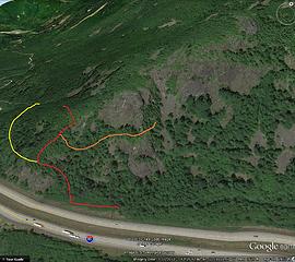 Red is our route down to I-90
Yellow is faint route back to 38
Orange is climbers trail to bouldering areas
|
| Back to top |
|
|
Bernardo
Member
Joined: 08 Feb 2010
Posts: 2174 | TRs | Pics
Location: out and about in the world |
|
Bernardo
Member
|
Fri May 24, 2013 1:21 pm |
|
|
Shakawkari, thanks for sharing your explorations of the area. I think I would say that it is not that easy to make the connection.
|
| Back to top |
|
|
Chris S
Member
Joined: 08 Sep 2013
Posts: 3 | TRs | Pics
|
|
Chris S
Member
|
Fri Oct 25, 2013 6:48 am |
|
|
I've hiked the Balcony and PPP trails a few times this summer, most recently to show the missus the view from the Balcony about three weeks ago. The signs for the Exit 42 and PPP junctions are now missing.
What is your opinion about signage? I know of another location (to remain anonymous right now) where the local users are considering adding signs to help keep people on the established trails. There are several sections of braids, errosive and sub-optimal short-cuts, and a few "regulars" are thinking of signs as a way to direct and redirect traffic onto the best paths.
|
| Back to top |
|
|
whitebark
Member

Joined: 08 Jul 2005
Posts: 1864 | TRs | Pics
Location: Seattle |
I liked the little signs on the PPP trail. Wonder who is removing them? It could be NF rangers maintaining the unofficial status of the trail.
|
| Back to top |
|
|
nordique
Member

Joined: 04 May 2008
Posts: 1086 | TRs | Pics
|
|
nordique
Member
|
Fri Oct 25, 2013 4:45 pm |
|
|
Actually, it's usually called the Birdbox Trail, rather than birdhouse. I've done the Birdbox Trail many times to DHB and just once the traverse to exit 42--which, the way we went--involved crossing a vigorous creek via a huge log, which not everyone dared to cross (one hiker plunged into thigh-deep water to make the crossing). I was told that the great trail out of exit 42 was built by a DOT crew, perhaps to put a repeater up on the ridge, but the crew supervisor eventually was over-ruled by his boss and the path was abandoned.
|
| Back to top |
|
|
whitebark
Member

Joined: 08 Jul 2005
Posts: 1864 | TRs | Pics
Location: Seattle |
Yeah, during the snowmelt season the Balcony Traverse Trail crosses some pretty vigorous creeks. So it was a DOT crew that built the trail up towards PPP....interesting. Thei DOT crew did a good job with that trail - it is built wide and with a good grade, although years of neglect have taken their toll. You can see the exact spot where they gave up.
|
| Back to top |
|
|
|
|


