| Previous :: Next Topic |
| Author |
Message |
iron
Member


Joined: 10 Aug 2008
Posts: 6392 | TRs | Pics
Location: southeast kootenays |
|
iron
Member
|
 Wed Sep 11, 2013 9:53 pm |
|
|
 the pickets area was new terrain for us. sure, we'd read reports, talked to a handful of knowledgable people, and figured we had the route dialed in. should be no sweat, right? well, if there was anything we learned from this trip, it's not to underestimate the pickets!
after months of planning and potential partner discussions, it ended up being just me and hotpantz. fitting enough.
the forecast appeared to have tanked a bit before we departed. the first rains in many weeks were just wrapping up as we left. our expectation was to get wet for the first day or two and to be okay with it. in the end, we had as perfect of weather as you could ever ask for in the pickets. in fact, it often seemed that the pickets had far better weather than all the surrounding areas. are all the rumors simply lies? are the pickets really just an extension of sequim? based on our 7 1/3 days up there, i can only deduce that, yes, the pickets are undoubtedly in a rain shadow and will always offer perfect hiking conditions...
the pickets area was new terrain for us. sure, we'd read reports, talked to a handful of knowledgable people, and figured we had the route dialed in. should be no sweat, right? well, if there was anything we learned from this trip, it's not to underestimate the pickets!
after months of planning and potential partner discussions, it ended up being just me and hotpantz. fitting enough.
the forecast appeared to have tanked a bit before we departed. the first rains in many weeks were just wrapping up as we left. our expectation was to get wet for the first day or two and to be okay with it. in the end, we had as perfect of weather as you could ever ask for in the pickets. in fact, it often seemed that the pickets had far better weather than all the surrounding areas. are all the rumors simply lies? are the pickets really just an extension of sequim? based on our 7 1/3 days up there, i can only deduce that, yes, the pickets are undoubtedly in a rain shadow and will always offer perfect hiking conditions...  day 0
after horrendous traffic departing seattle (probably the norm), we stopped at the marblemount ranger station for permits. i'm continually surprised that the people staffing the desk know little to nothing about the areas we need to register for. after securing the permits, we headed out to a crowded ross lake TH and dropped off one car; then, we drove back on hwy 20 to hwy 9 and up to the hannegan pass TH which was also crowded. the bed of the subaru made for an excellent night's sleep while the clouds and fog rolled in and out.
day 1
day 0
after horrendous traffic departing seattle (probably the norm), we stopped at the marblemount ranger station for permits. i'm continually surprised that the people staffing the desk know little to nothing about the areas we need to register for. after securing the permits, we headed out to a crowded ross lake TH and dropped off one car; then, we drove back on hwy 20 to hwy 9 and up to the hannegan pass TH which was also crowded. the bed of the subaru made for an excellent night's sleep while the clouds and fog rolled in and out.
day 1
 okay, buckarinos. time to hoist the packs. we had 8.5 days of food which we figured would give us a weather day + a hungry half a day if needed. aside from standard glacier gear, we had a light alpine rack and a 60m rope that r3h lent us for the trip; thanks bud!
the second you start walking with packs this heavy, you begin questioning how you're going to make it to your first night's destination, let alone through the whole trip. eesh. i always like to compare what a trail felt like with only a day pack compared to a multinight pack, so while the hannegan pass trail is generally flat, it didn't feel like it today.
okay, buckarinos. time to hoist the packs. we had 8.5 days of food which we figured would give us a weather day + a hungry half a day if needed. aside from standard glacier gear, we had a light alpine rack and a 60m rope that r3h lent us for the trip; thanks bud!
the second you start walking with packs this heavy, you begin questioning how you're going to make it to your first night's destination, let alone through the whole trip. eesh. i always like to compare what a trail felt like with only a day pack compared to a multinight pack, so while the hannegan pass trail is generally flat, it didn't feel like it today.
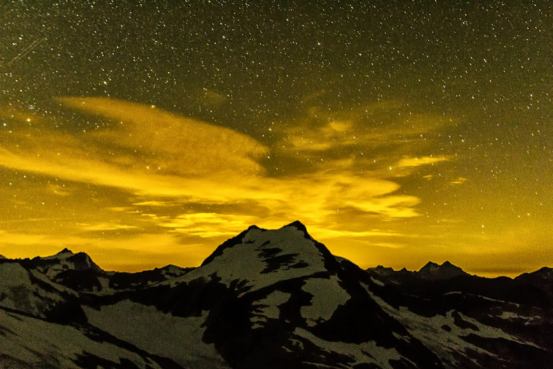
 falling  clouds did their valley-filling-awesomeness thing to wake us up. such a treat to see and experience!
we packed up, happy to be 2lbs/each lighter than the day before, and continued up the not-so-easy ridge. again, constantly evolving beautiful views serve as fine encouragement. campsites were possible pretty much every 100ft vertical, with water (running or in tarn-form) nearby.
the trail peters out a bit at the only steep part of the ridge, but then picks back up for some fine alpine ridge walking with views of the southern pickets and partial peeks at perfect pass.
the heather was especially beautiful and vibrant. if one didn't have the inclination to go into the pickets, but wanted up front seating, this would be a fine destination, especially at the lake below (easy lake? - somehow i don't have a pic!).
we crossed over easy peak, plodded along the ridge, and eventually dropped in via a talus and snow field. uncomfortable with the heavy weight of my pack, i avoided snow whenever possible.
the slabs and waterfalls along the way towards imperfect impasse (II) are second to none. very beautiful and very plentiful. it was a stark shift from the completely dry ascent from chilliwack river and the relatively dry walk from camp to easy peak.
quickly, the landscape changes. II is bulky and scary looking. so is much of the SW side of whatcom peak. in fact, most sides of whatcom, minus the SE side, are pretty scary to some extent. and beyond II is a hulking beautiful glacier which markedly ends the rock portion of the trip. not only is it an abrupt change, it's also one of the largest glaciers in the state.
after reading matt and stefan's recent TRs about imperfect impasse, and their choice to drop low, i was more than inclined to spend some time searching for the higher route through. the other group ahead of us went the low route. it was the last we saw of them and we can only assume they bailed on their attempt of challenger shortly thereafter.
from the base of the II, if you walk over to the gorged out impasse, you see above you many routes that could work. the goal, it seemed (without snow in the impasse), was to reach the portion of the buttress where it joined somewhat smoothly with the gully rather than a 20-100ft dropoff. i searched multiple routes for over an hour. there are many ramp possibilities that seem to take you in the right direction, but then have a move or two that is beyond 4th class and not all that logical with a heavy, tipsy pack. up and down and up and down i went, occasionally entering and exiting 5th class slabs. some solid, some not. eesh, i thought. no way we're getting through here with big packs on.
as i stood on the ridge proper of the rib, and communicated with hotpantz as to the best way down to admit my defeat, i saw it. the ramp. the gps said ~5200' when i took off on it on a slight upward trajectory which then headed slightly down towards the gully. there were patches of flowers and some of the only green plants i saw on this portion of the II. as it neared the gully itself, the scrambling got a little more involved. first, solid 3rd class, but then, legit 4th class involving a few long steps with decent hands and feet - might as well be 5th class - like 5.0. a few 4th class moves later, i was standing in the gully. sweet. now, memorize everything, hurry back to the pack, and let's get done with this thing!
we grabbed the packs and headed up. i left two trekking poles and a small cairn to mark the way. with the heavy pack, it was more committing for sure. adios agility! slowly and surely, we crossed. then, in the gully, we headed up about 40-60ft vert to a place that exited nicely via a slab ramp with okay feet and an underclung handhold. as if to reward us, a few perfectly ripe berries were right above us at this point. i set down my pack and went back for hotpantz' pack. after having done the II 5 times, i felt like i had it down. if anyone needs a guide, well... below are pics hotpantz shot of me going back and forth those few times. hopefully they provide detail as to where to go.
further up above where we crossed, there is another very obvious green ramp that looked like it would go roughly the same. there were some spots we could not see for sure, but i suspect it goes at about the same difficulty.
once on the other side, more incredibly beautiful slab waterfalls flowed all around us. wow.
then, just the small task of picking our way up towards perfect pass. it was steep, with an occasional boot path here or there. no where before have i seen such defined bootprint steps (not a path - just steps). whoever put in the first steps must've been about 9ft tall!
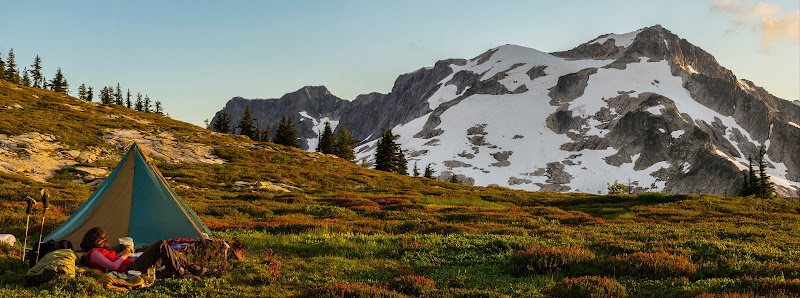
perfect pass is, naturally, perfectly named. what a view!
a few campsites present themselves just left of the pass. further up, another few emerge. running water to boot! just as we got to the pass, we saw a group of 4 descending from whatcom peak. we raced to find the best campsite and quickly set up.
next, we packed a pleasantly light pack before heading up to whatcom peak to beat the sunset. crampons and axe are all that's necessary. some hello's were exchanged with the other group - two couples - where we found out they would be heading to challenger and out via eiley wiley. their approach was via whatcom pass and the north ridge of whatcom where they reported nice class three terrain with the occasional puzzle to solve.
the snow was perfect for crampons and we made short work of the elevation to the rocky ridge near the summit. the ridge is awesome! almost knife edged, but entirely class 3. the fading light and glowing orange ball of sun enhanced the aesthetics of this climb.
on the way down, we were treated to perhaps the best light show we've ever seen. t-storms were billowing in the E, mostly at challenger and beyond. they exploded upward, occasionally casting out bolts of lightning. meanwhile, perfect pass was still perfect.
clouds did their valley-filling-awesomeness thing to wake us up. such a treat to see and experience!
we packed up, happy to be 2lbs/each lighter than the day before, and continued up the not-so-easy ridge. again, constantly evolving beautiful views serve as fine encouragement. campsites were possible pretty much every 100ft vertical, with water (running or in tarn-form) nearby.
the trail peters out a bit at the only steep part of the ridge, but then picks back up for some fine alpine ridge walking with views of the southern pickets and partial peeks at perfect pass.
the heather was especially beautiful and vibrant. if one didn't have the inclination to go into the pickets, but wanted up front seating, this would be a fine destination, especially at the lake below (easy lake? - somehow i don't have a pic!).
we crossed over easy peak, plodded along the ridge, and eventually dropped in via a talus and snow field. uncomfortable with the heavy weight of my pack, i avoided snow whenever possible.
the slabs and waterfalls along the way towards imperfect impasse (II) are second to none. very beautiful and very plentiful. it was a stark shift from the completely dry ascent from chilliwack river and the relatively dry walk from camp to easy peak.
quickly, the landscape changes. II is bulky and scary looking. so is much of the SW side of whatcom peak. in fact, most sides of whatcom, minus the SE side, are pretty scary to some extent. and beyond II is a hulking beautiful glacier which markedly ends the rock portion of the trip. not only is it an abrupt change, it's also one of the largest glaciers in the state.
after reading matt and stefan's recent TRs about imperfect impasse, and their choice to drop low, i was more than inclined to spend some time searching for the higher route through. the other group ahead of us went the low route. it was the last we saw of them and we can only assume they bailed on their attempt of challenger shortly thereafter.
from the base of the II, if you walk over to the gorged out impasse, you see above you many routes that could work. the goal, it seemed (without snow in the impasse), was to reach the portion of the buttress where it joined somewhat smoothly with the gully rather than a 20-100ft dropoff. i searched multiple routes for over an hour. there are many ramp possibilities that seem to take you in the right direction, but then have a move or two that is beyond 4th class and not all that logical with a heavy, tipsy pack. up and down and up and down i went, occasionally entering and exiting 5th class slabs. some solid, some not. eesh, i thought. no way we're getting through here with big packs on.
as i stood on the ridge proper of the rib, and communicated with hotpantz as to the best way down to admit my defeat, i saw it. the ramp. the gps said ~5200' when i took off on it on a slight upward trajectory which then headed slightly down towards the gully. there were patches of flowers and some of the only green plants i saw on this portion of the II. as it neared the gully itself, the scrambling got a little more involved. first, solid 3rd class, but then, legit 4th class involving a few long steps with decent hands and feet - might as well be 5th class - like 5.0. a few 4th class moves later, i was standing in the gully. sweet. now, memorize everything, hurry back to the pack, and let's get done with this thing!
we grabbed the packs and headed up. i left two trekking poles and a small cairn to mark the way. with the heavy pack, it was more committing for sure. adios agility! slowly and surely, we crossed. then, in the gully, we headed up about 40-60ft vert to a place that exited nicely via a slab ramp with okay feet and an underclung handhold. as if to reward us, a few perfectly ripe berries were right above us at this point. i set down my pack and went back for hotpantz' pack. after having done the II 5 times, i felt like i had it down. if anyone needs a guide, well... below are pics hotpantz shot of me going back and forth those few times. hopefully they provide detail as to where to go.
further up above where we crossed, there is another very obvious green ramp that looked like it would go roughly the same. there were some spots we could not see for sure, but i suspect it goes at about the same difficulty.
once on the other side, more incredibly beautiful slab waterfalls flowed all around us. wow.
then, just the small task of picking our way up towards perfect pass. it was steep, with an occasional boot path here or there. no where before have i seen such defined bootprint steps (not a path - just steps). whoever put in the first steps must've been about 9ft tall!
perfect pass is, naturally, perfectly named. what a view!
a few campsites present themselves just left of the pass. further up, another few emerge. running water to boot! just as we got to the pass, we saw a group of 4 descending from whatcom peak. we raced to find the best campsite and quickly set up.
next, we packed a pleasantly light pack before heading up to whatcom peak to beat the sunset. crampons and axe are all that's necessary. some hello's were exchanged with the other group - two couples - where we found out they would be heading to challenger and out via eiley wiley. their approach was via whatcom pass and the north ridge of whatcom where they reported nice class three terrain with the occasional puzzle to solve.
the snow was perfect for crampons and we made short work of the elevation to the rocky ridge near the summit. the ridge is awesome! almost knife edged, but entirely class 3. the fading light and glowing orange ball of sun enhanced the aesthetics of this climb.
on the way down, we were treated to perhaps the best light show we've ever seen. t-storms were billowing in the E, mostly at challenger and beyond. they exploded upward, occasionally casting out bolts of lightning. meanwhile, perfect pass was still perfect.
|
| Back to top |
  
|
|
iron
Member
Joined: 10 Aug 2008
Posts: 6392 | TRs | Pics
Location: southeast kootenays |
|
iron
Member
|
Wed Sep 11, 2013 9:56 pm |
|
|
day 3
 based on the mileage, we assumed this would be a short day. i mean, we only had to make it across the challenger glacier, drop packs, climb the peak, and head a little further down challenger arm to campsites. can't take long, right?!
from perfect pass, we headed up the ridge; a route from perfect pass directly to the glacier seemed like it would require a rappel or loose downclimbng. a bootpath, occasionally faint, guides you up. en route, you pass wreckage and a memorial plaque from a helicopter rescue mission gone wrong.
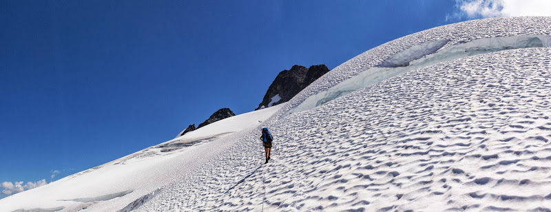
we crossed over two bumps on the ridge, passing a cool slab wall, before droping onto the glacier. this was a big glacier. huge yawning crevasses everywhere, above and below. while it seems like, from the map, that you'd want to contour roughly level to hit challenger arm, crevasses and icefall at those elevations generally prevent taking that route. it could be done, but at higher risk.
hitting the ridge at EL7500', we happily cast off our ballast, anchoring it to the snow with trekking poles. i also left my DSLR, which i later regretted. but, when a summit calls, a summit calls!
up the ridge we went, eventually zigging around a good sized crevasse. soon, it was time to overcome the moat - the one that was potentially a dealbreaker. around EL7960, a moat forms each year. recent beta suggested it would be out, but we hoped to find an alternative way up. we had footprints to follow from the group of 4, so this became a mostly trivial affair, though i'm sure our route would have been nearly identical.
we walked down into the moat where plenty of snow still covered the rock. it was that semi-hard snow you typically see in locations like these - the kind where you're not sure your step will hold. once beyond that snow, we picked up a rock ridge just L of the normal climber's snow route. heading up maybe 30ft, we then regained the snow ridge on the uphill side of the moat. i protected the steep slopes with 3 pickets on a running belay. with the 60m rope, and good picket placement i was able to make it to a rock outcrop that i quickly slung and belayed from.
from here, it was easy walking to the base of the climb. no more snow gear, just rock gear. we chatted with the group of 4 who had just rapped from the summit. they reported excellent times and a real 5.7 move.
we poked around and found the awesome belay ledge for the standard climb route. three pitons, placed incredibly close, were clipped. i also placed a .5 cam at the 'crux' move to limit a pendulum. the move itself was harder than i thought it'd be. a slight bulge and only one good foot. after a few minutes of looking for the best combination of holds, i got past it and walked up to another really nice belay station where people rappel from and proceded to belay up hotpantz. she cruised through the move and we walked to the summit. amazingly steep terrain everywhere. it's crazy this stuff stands up!
we rapped the route (a 30m might do, definitely a 35m) and grabbed our snow gear and proceded down. we again protected with the three pickets we brought and followed a different set of steps from the group of 4 that got onto the rock ridge at a less-steep section of snow than our up route. that group buried a picket and rapped from it once on the rock, but we figured it was easy enough going down the rock, so i pulled their picket and later returned it to them. two more raps on new and existing slings got us back to the moat where the golden glow of the fading sun gave the snow an unreal look.
we didn't quite make it into camp by the time sun set, but whatever. it was warm and we found a great spot for the tent - though it required a bit of engineering to make some of the anchors work. running water was found about 200ft below the pass to the W, though more was found the next day coming off the eiley wiley ridge. probably a push on total time, but easier for the eiley wiley water.
day 4
based on the mileage, we assumed this would be a short day. i mean, we only had to make it across the challenger glacier, drop packs, climb the peak, and head a little further down challenger arm to campsites. can't take long, right?!
from perfect pass, we headed up the ridge; a route from perfect pass directly to the glacier seemed like it would require a rappel or loose downclimbng. a bootpath, occasionally faint, guides you up. en route, you pass wreckage and a memorial plaque from a helicopter rescue mission gone wrong.
we crossed over two bumps on the ridge, passing a cool slab wall, before droping onto the glacier. this was a big glacier. huge yawning crevasses everywhere, above and below. while it seems like, from the map, that you'd want to contour roughly level to hit challenger arm, crevasses and icefall at those elevations generally prevent taking that route. it could be done, but at higher risk.
hitting the ridge at EL7500', we happily cast off our ballast, anchoring it to the snow with trekking poles. i also left my DSLR, which i later regretted. but, when a summit calls, a summit calls!
up the ridge we went, eventually zigging around a good sized crevasse. soon, it was time to overcome the moat - the one that was potentially a dealbreaker. around EL7960, a moat forms each year. recent beta suggested it would be out, but we hoped to find an alternative way up. we had footprints to follow from the group of 4, so this became a mostly trivial affair, though i'm sure our route would have been nearly identical.
we walked down into the moat where plenty of snow still covered the rock. it was that semi-hard snow you typically see in locations like these - the kind where you're not sure your step will hold. once beyond that snow, we picked up a rock ridge just L of the normal climber's snow route. heading up maybe 30ft, we then regained the snow ridge on the uphill side of the moat. i protected the steep slopes with 3 pickets on a running belay. with the 60m rope, and good picket placement i was able to make it to a rock outcrop that i quickly slung and belayed from.
from here, it was easy walking to the base of the climb. no more snow gear, just rock gear. we chatted with the group of 4 who had just rapped from the summit. they reported excellent times and a real 5.7 move.
we poked around and found the awesome belay ledge for the standard climb route. three pitons, placed incredibly close, were clipped. i also placed a .5 cam at the 'crux' move to limit a pendulum. the move itself was harder than i thought it'd be. a slight bulge and only one good foot. after a few minutes of looking for the best combination of holds, i got past it and walked up to another really nice belay station where people rappel from and proceded to belay up hotpantz. she cruised through the move and we walked to the summit. amazingly steep terrain everywhere. it's crazy this stuff stands up!
we rapped the route (a 30m might do, definitely a 35m) and grabbed our snow gear and proceded down. we again protected with the three pickets we brought and followed a different set of steps from the group of 4 that got onto the rock ridge at a less-steep section of snow than our up route. that group buried a picket and rapped from it once on the rock, but we figured it was easy enough going down the rock, so i pulled their picket and later returned it to them. two more raps on new and existing slings got us back to the moat where the golden glow of the fading sun gave the snow an unreal look.
we didn't quite make it into camp by the time sun set, but whatever. it was warm and we found a great spot for the tent - though it required a bit of engineering to make some of the anchors work. running water was found about 200ft below the pass to the W, though more was found the next day coming off the eiley wiley ridge. probably a push on total time, but easier for the eiley wiley water.
day 4
 rest day. ahh. so nice. well, not full rest. just rest without packs. we slept in then rolled out to tag some of the bumps along eiley wiley ridge. firm snow led us from camp up the ridge. an easy ascent brought us to the top of 7374, which goes by multiple names.
we then came off its summit to the S to get through a notch on the E ridge. some looseness, but not bad. once through the notch, we had easy walking on the wiley glacier. we didn't bring a rope, so we were happy to see a lack of crevasses on this route. further W of our route were crevasses, so we stayed away from that.
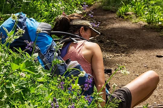
wiley lake was still frozen. i can't imagine this sees many years where it melts out all the way. next up was 7049, known as beheaded dog burying bone. weird name, right? but, on the summit, hotpantz spotted a rock that might just be its namesake!
i tried running the ridge towards the next objective, 6984 (also multiple names), but an impassable cleft in the ridge prevented that quest. i retreated and joined back up with hotpantz who had gone down to eiley lake for a swim and R&R. this water may have been the coldest either of us have swam in. sure, we've been in tarns before with ice, but for whatever reason, this one was damned cold! at least there were some pretty incredible flat rocks to lay out upon.
while hotpantz suntanned and slept, i continued on toward 6984. pretty easy travel for the most part with some steep heather near the summit. i signed the fay pullen register (no other entries) and headed back for some of my own R&R.
after a few hours at the lake, we eventually gave in and went back to our challenger arm camp. it was nice to be at a camp without having carried the camping weight too! the stars that night were quite nice.
rest day. ahh. so nice. well, not full rest. just rest without packs. we slept in then rolled out to tag some of the bumps along eiley wiley ridge. firm snow led us from camp up the ridge. an easy ascent brought us to the top of 7374, which goes by multiple names.
we then came off its summit to the S to get through a notch on the E ridge. some looseness, but not bad. once through the notch, we had easy walking on the wiley glacier. we didn't bring a rope, so we were happy to see a lack of crevasses on this route. further W of our route were crevasses, so we stayed away from that.
wiley lake was still frozen. i can't imagine this sees many years where it melts out all the way. next up was 7049, known as beheaded dog burying bone. weird name, right? but, on the summit, hotpantz spotted a rock that might just be its namesake!
i tried running the ridge towards the next objective, 6984 (also multiple names), but an impassable cleft in the ridge prevented that quest. i retreated and joined back up with hotpantz who had gone down to eiley lake for a swim and R&R. this water may have been the coldest either of us have swam in. sure, we've been in tarns before with ice, but for whatever reason, this one was damned cold! at least there were some pretty incredible flat rocks to lay out upon.
while hotpantz suntanned and slept, i continued on toward 6984. pretty easy travel for the most part with some steep heather near the summit. i signed the fay pullen register (no other entries) and headed back for some of my own R&R.
after a few hours at the lake, we eventually gave in and went back to our challenger arm camp. it was nice to be at a camp without having carried the camping weight too! the stars that night were quite nice.
|
| Back to top |
|
|
iron
Member
Joined: 10 Aug 2008
Posts: 6392 | TRs | Pics
Location: southeast kootenays |
|
iron
Member
|
Wed Sep 11, 2013 9:56 pm |
|
|
day 5
 finally, we were picking up on the idea that the pickets deserve some respect and that earlier starts are warranted. i think we left camp around 8am as we said our goodbyes to the challenger glacier world.
we roped up to round the corner of the glacier extending into luna cirque. probably not necessary, but better safe than sorry when you don't know a route. once at the corner, we saw camp primo and one heck of a view. we soaked in this moment for a good half hour.
from here, the route ahead looks impossible. you glance at the map, and see the contours you want to hit, and it looks okay on paper... man, paper and rocks don't always agree! good thing we didn't have scissors around, or all hell would've broken loose!
actually, we ended up nailing the exact route we wanted. but again, it took awhile. some of that was just the sheer beauty of the area slowing us down. this tiny pocket of the cascades is as alive and changing as anywhere we've ever been. rock and icefall come crashing down every couple minutes. it's crazy to witness it from afar, realizing that what you're seeing is moving at multiple 100's of mph, but it barely looks like it's even moving. scale and perception are pretty amazing sometime.
the start of luna cirque may be as beautiful as it gets. hanging glaciers, blooming heather, and incredible slab waterfalls progressively get bigger and better with each passing step.
the goal of the inital traverse is to get around a buttress. in good weather, it's quite obvious. and, if you've made it this far, you'll probably be able to get to the buttress several amazing slab waterfalls present both beauty and challenge as you work your way through.
once around the buttress, we continued over and down, eventually reaching an area where streaks of slide alder extend to the cirque floor. because we wanted to avoid rockfall, icefall, and, most importantly, us-fall, we opted to continue all the way down below where the glaciers/permanent snow are shown on the map. the going through the alder was really easy and essentially brush-free.
once down, we reached an out-of-character flat spot which was followed by huge, high glacial moraine rock piles that were as stable as a chair with two legs. fun. this fan of the moraine was probably stacked 100ft high.
with rockfall pouring down above us every few minutes, we continued down all the way to lousy lake. i know now why it gets that name. the lake itself = beautiful. the way in which one gets there = lousy. no other way around that fact!
best of all, not only was every rock loose, every rock was scattered over a glacier with clear ice underneath. occasionally you'd come across what looked like sinkholes or chasms within the ice with water running somewhere deep below. "stay back" it screamed.
as we rounded the S end of lousy lake, i got to use up my 2nd cat's life. we were walking level, on rocks of course, with about 5ft between myself and hotpantz. she was first, i was second. somehow, between us, a rock that i estimate at 3000lbs decided to topple over. i first saw it tilt backwards, somehow, and then just go a rumblin' down. because i drink milk, i still have quick reflexes (or so the commercials say). i was about 1/2 second from game over.
now, time to get up to luna lake. a narrow rib with occasional alder and occasional path heads up. the path is helpful for sneaking through the brush. once you get up several hundred feet, the alder goes away and heather-dotted rocks emerge. the views of the luna lake outlet waterfall are front and center for this journey and they make one completely forget about the lousy toils of lousy lake.
we were in a race with the sun as it was setting behind challenger. our pace up seemed to match its pace down. the goal at this point became trying to get to the lake for a swim before we lost the direct light. mud-caked rocks and soft dirt slowed us as we neared the outlet, but we were able to make it roughly in time. we crossed over some rocks at the outlet, stripped down, and jumped in. luckily the icebergs in the lake posed little hazard other than visual intimidation. it was refreshing.
two semi-established campsites on the north side of the lake gave us a few nice camping options as we enjoyed a restful evening. the sun even came back 'out' as it came around the summit block of challenger. meanwhile, we had all these new glaciers to look at, including the one that fed directly into luna lake. oh yeah, fury too!
day 6
finally, we were picking up on the idea that the pickets deserve some respect and that earlier starts are warranted. i think we left camp around 8am as we said our goodbyes to the challenger glacier world.
we roped up to round the corner of the glacier extending into luna cirque. probably not necessary, but better safe than sorry when you don't know a route. once at the corner, we saw camp primo and one heck of a view. we soaked in this moment for a good half hour.
from here, the route ahead looks impossible. you glance at the map, and see the contours you want to hit, and it looks okay on paper... man, paper and rocks don't always agree! good thing we didn't have scissors around, or all hell would've broken loose!
actually, we ended up nailing the exact route we wanted. but again, it took awhile. some of that was just the sheer beauty of the area slowing us down. this tiny pocket of the cascades is as alive and changing as anywhere we've ever been. rock and icefall come crashing down every couple minutes. it's crazy to witness it from afar, realizing that what you're seeing is moving at multiple 100's of mph, but it barely looks like it's even moving. scale and perception are pretty amazing sometime.
the start of luna cirque may be as beautiful as it gets. hanging glaciers, blooming heather, and incredible slab waterfalls progressively get bigger and better with each passing step.
the goal of the inital traverse is to get around a buttress. in good weather, it's quite obvious. and, if you've made it this far, you'll probably be able to get to the buttress several amazing slab waterfalls present both beauty and challenge as you work your way through.
once around the buttress, we continued over and down, eventually reaching an area where streaks of slide alder extend to the cirque floor. because we wanted to avoid rockfall, icefall, and, most importantly, us-fall, we opted to continue all the way down below where the glaciers/permanent snow are shown on the map. the going through the alder was really easy and essentially brush-free.
once down, we reached an out-of-character flat spot which was followed by huge, high glacial moraine rock piles that were as stable as a chair with two legs. fun. this fan of the moraine was probably stacked 100ft high.
with rockfall pouring down above us every few minutes, we continued down all the way to lousy lake. i know now why it gets that name. the lake itself = beautiful. the way in which one gets there = lousy. no other way around that fact!
best of all, not only was every rock loose, every rock was scattered over a glacier with clear ice underneath. occasionally you'd come across what looked like sinkholes or chasms within the ice with water running somewhere deep below. "stay back" it screamed.
as we rounded the S end of lousy lake, i got to use up my 2nd cat's life. we were walking level, on rocks of course, with about 5ft between myself and hotpantz. she was first, i was second. somehow, between us, a rock that i estimate at 3000lbs decided to topple over. i first saw it tilt backwards, somehow, and then just go a rumblin' down. because i drink milk, i still have quick reflexes (or so the commercials say). i was about 1/2 second from game over.
now, time to get up to luna lake. a narrow rib with occasional alder and occasional path heads up. the path is helpful for sneaking through the brush. once you get up several hundred feet, the alder goes away and heather-dotted rocks emerge. the views of the luna lake outlet waterfall are front and center for this journey and they make one completely forget about the lousy toils of lousy lake.
we were in a race with the sun as it was setting behind challenger. our pace up seemed to match its pace down. the goal at this point became trying to get to the lake for a swim before we lost the direct light. mud-caked rocks and soft dirt slowed us as we neared the outlet, but we were able to make it roughly in time. we crossed over some rocks at the outlet, stripped down, and jumped in. luckily the icebergs in the lake posed little hazard other than visual intimidation. it was refreshing.
two semi-established campsites on the north side of the lake gave us a few nice camping options as we enjoyed a restful evening. the sun even came back 'out' as it came around the summit block of challenger. meanwhile, we had all these new glaciers to look at, including the one that fed directly into luna lake. oh yeah, fury too!
day 6
 by now, pack weight was more tolerable and our spirits were higher and higher as we had made it through what we figured would be the more challenging parts of the trip. we headed more or less E from the lake up beautiful rock, heather, and TREED slopes. not having seen trees in a few days plays with one's mind when you see them again - like somehow you're in a new part of the world again. not only were there trees, but they were larch trees!
about midway up to luna col, we came to my happy place. while i thought i found the place for my ashes to go someday on last year's big trip, i need to rescind that location in order to change it to this one - which is sadly harder to get to for whomever has that chore...
the happy place consisted of buzzing bees, a rounded rock outcrop with about 8 waterfalls coming off it in every direction, blooming heather, the occasional flower, and of course the larch trees. nice white granite rocks always compliment a scene like this, so they were in there for good measure. oh, and if you turn around, you see all of luna cirque. yeah, it was okay.
we sat there for a half hour.
from there, we followed a mix of slabs and minor amounts of snow to reach luna col. while there would have been more sunlight than our luna lake campsite, we were glad we stayed at luna lake; there's something about camping "in" an area compared to above it. plus, views to the E of luna col, while still nice, deteriorate.
packs off, we hiked up the easy ridge towards luna. for months i have been sending pictures to friends with little captions reading "luna says climb me" - an attempt to garner interest from others in this trip. well, today was the day. at the false summit, the route becomes less cakewalk, and more sidewalk. lots of sidewalks actually. we went many directions on this peak, taking ramp after ramp. eventually, you just have to go up.
the exposure is somewhat high and the summit is not that comfortable to sit on. sure, you get a few extra views compared to the false summit, but not by much.
while on top, we commenced our plan to change our boat pickup time on ross lake. only problem: no reception. i had read reports of previous parties that were able to make phone contact from here. not sure why ours didn't. oh well, we like carrying extra weight anyway.
we got to view two sets of birds from our summit perch: some bald eagles and BLACK SWIFTS! so cool. ever since reading the pilchuck - life of a mountain, book, i have wanted to see these guys. a pair of them circled the summit many times. they were very playful and chatty. and the noise they made while zooming by sounded like they were shredding some kind of vortex. it was awesome!
the down went fine and we grabbed our packs and waved goodbye to luna cirque, not knowing if we'll ever get this view again. now, to get to access creek gully or somewhere above it to camp.
the terrain, of course, was moderately complicated. creeks and buttresses occasionally blocked the logical way. having not seen this area from the other side, which would surely give you a better clue on where to go, it took a bit of searching to find ways through. after awhile, i started talking to the pikas, saying: eep, where the hell are we going, eep. water was abundant for the first 2/3 of the traverse, but then non-existant after that. hotpantz and her 20/10 vision declared no more water sources ahead, so we loaded up before getting to where we thought we could camp.
the first main gully off luna's SE ridge looks like it "could" go based on the map. umm, not a good idea. same with the second gully. there were, however, some ragged campsites right above that second gully that timed well with our current location and time of day. this site took the most work to get the circus tent up, and i was hoping for a wind/rain free night since the tent walls were not taut. surprisingly, despite the ground underneath our makeshift groundcloth, i slept very well. it also offered great views towards the southern pickets, the approach from stetattle ridge, and, of course, sourpatch!
day 7
by now, pack weight was more tolerable and our spirits were higher and higher as we had made it through what we figured would be the more challenging parts of the trip. we headed more or less E from the lake up beautiful rock, heather, and TREED slopes. not having seen trees in a few days plays with one's mind when you see them again - like somehow you're in a new part of the world again. not only were there trees, but they were larch trees!
about midway up to luna col, we came to my happy place. while i thought i found the place for my ashes to go someday on last year's big trip, i need to rescind that location in order to change it to this one - which is sadly harder to get to for whomever has that chore...
the happy place consisted of buzzing bees, a rounded rock outcrop with about 8 waterfalls coming off it in every direction, blooming heather, the occasional flower, and of course the larch trees. nice white granite rocks always compliment a scene like this, so they were in there for good measure. oh, and if you turn around, you see all of luna cirque. yeah, it was okay.
we sat there for a half hour.
from there, we followed a mix of slabs and minor amounts of snow to reach luna col. while there would have been more sunlight than our luna lake campsite, we were glad we stayed at luna lake; there's something about camping "in" an area compared to above it. plus, views to the E of luna col, while still nice, deteriorate.
packs off, we hiked up the easy ridge towards luna. for months i have been sending pictures to friends with little captions reading "luna says climb me" - an attempt to garner interest from others in this trip. well, today was the day. at the false summit, the route becomes less cakewalk, and more sidewalk. lots of sidewalks actually. we went many directions on this peak, taking ramp after ramp. eventually, you just have to go up.
the exposure is somewhat high and the summit is not that comfortable to sit on. sure, you get a few extra views compared to the false summit, but not by much.
while on top, we commenced our plan to change our boat pickup time on ross lake. only problem: no reception. i had read reports of previous parties that were able to make phone contact from here. not sure why ours didn't. oh well, we like carrying extra weight anyway.
we got to view two sets of birds from our summit perch: some bald eagles and BLACK SWIFTS! so cool. ever since reading the pilchuck - life of a mountain, book, i have wanted to see these guys. a pair of them circled the summit many times. they were very playful and chatty. and the noise they made while zooming by sounded like they were shredding some kind of vortex. it was awesome!
the down went fine and we grabbed our packs and waved goodbye to luna cirque, not knowing if we'll ever get this view again. now, to get to access creek gully or somewhere above it to camp.
the terrain, of course, was moderately complicated. creeks and buttresses occasionally blocked the logical way. having not seen this area from the other side, which would surely give you a better clue on where to go, it took a bit of searching to find ways through. after awhile, i started talking to the pikas, saying: eep, where the hell are we going, eep. water was abundant for the first 2/3 of the traverse, but then non-existant after that. hotpantz and her 20/10 vision declared no more water sources ahead, so we loaded up before getting to where we thought we could camp.
the first main gully off luna's SE ridge looks like it "could" go based on the map. umm, not a good idea. same with the second gully. there were, however, some ragged campsites right above that second gully that timed well with our current location and time of day. this site took the most work to get the circus tent up, and i was hoping for a wind/rain free night since the tent walls were not taut. surprisingly, despite the ground underneath our makeshift groundcloth, i slept very well. it also offered great views towards the southern pickets, the approach from stetattle ridge, and, of course, sourpatch!
day 7
 today was our last possible crux day --- getting over big beaver. well first, going through access creek, but that shouldn't be bad, right? we found a nice gully coming off the ridge leading down to access creek. a faint bootpack, probably seasonal, took us down much more easily than anticipated. it was steep, and a fall would not feel good, but it went.
near the bottom of the upper portion, i opted to go through trees and heather, while hotpantz went down to the left of them via what looked steeper to me. lesson: always trust wife on things like this! my tree route just hid the cliffs, wet slabs, and chasms better. when i finally exited, she was comfortably sitting on a rock, enjoying the company of pikas.
the route down into the thickness of the valley is actually pretty straightforward --- in part thanks to many pioneers that have tested it out and provided beta. basically, cross access creek at EL3800 to get to the north side (well cairned) and stay on that side the rest of the way to big beaver. great camping at EL4150 along with great old growth marmots too.
there's only one patch of slide alder and one patch of a decent amount of downfall. otherwise, it's just a moderately brushy forest with more downfall than you normally see in the cascades. lots of huckleberries to make your time more enjoyable.
for the first time since owning a garmin 60csx, it lot the signal around EL3200. the mighty access creek valley!
regardless, travel was easy. all the beta about staying within earshot of access creek is true. and eventually, you get spit out at big beaver. we happened to arrive exactly where there were < day old prints in the bottom of the river! not sure when that person was there, but it seemed kind of improbably crazy to me.
at this spot, there was a nice sandy beach. the river bent a bit at the corner and it was as wide as it got as far as we could see. seemed like a good/standard? place to cross, so that's what we tried. the sand proved mucky at first, with boots sinking past the ankle. eventually, a rocky bottom prevailed. by mid creek, i was crotch-deep (6'-0" tall). a few more steps and my fully extended trekking pole handle became submerged. eep. i backed out, went back to shore, and we schwacked for another couple of minutes through a vine maple and devils club laced shore.
after a few hundred feet, we reached a spot where we could gain the river again. in we went. this time, the river did not have a bend, which i determined was the key to crossing this river as the bend affects the flow rate and depth of water (progressively getting deeper/stronger). more crotch deep fording and i was across. then, i started taking photos of hotpantz, but nervousness and protect-my-wife-instincts took over so i got ready to plunge back in if necessary. she was fine. once across, we dunked to clean off, then proceeded through the old growth skunk cabbage swampland. soon, on trail. no more cruxes.
hotpantz swapped out shoes, whereas my crocs are thin and my desire to carry boots is low. instead, i had multiple sock swaps as we walked the surprisingly brushy trail. eventually things improved brush wise, though many of the creeks that should have been crossing the trail were dry.
we came across a trail maintenance crew leader and she let us know of 39 mile campground and that it might be open. it was. we were thankful to break up the death march out. 39 mile creek is quite nice for bathing and hanging out. as we set up the tent on a remarkably easy site, the skies flickered above. our perfect weather was about to end. good timing! sometime during the night it started to sprinkle. i continued to sleep very well, content our unknowns were no more.
day 8
easy trail walking on the big beaver trail. phew. big trees, dew covered everything, and no bugs made for a nice stroll. frogs and old growth toads everwhere! and old growth slugs!
eventually, clouds gave way to sun and we made our way back to the semi-crowded big beaver campground. lots of kayakers there. as a bonus, the water taxi was there right when we showed up. we were able to split the cost of the taxi with another group. no waiting at all.
a short ride later and we were heading up to the ross lake TH. the trip was over.
what did i learn?
- the pickets are hard
- the days felt hard
- i was drained for a lot of the trip
- i was happy to get out unscathed and without weather
- weeks after the trip, i wish i was back in the pickets
- my wife is very strong and dependable and i am lucky to have her join me on trips like this. even more impressive is that she's able to do this on two hips that are sadly deteriorating, in pain, and with constant range of movement constraints. she's so strong, it's ridiculous.
a few things we saw more of or stated more often than any other trip:
- old growth: paintbrush, marmot, pika, slugs, trees, heather, toads
- the use of the word "wild"
- big, loose rocks
- rockfall/icefall
- hanging glaciers
we were very fortunate on this trip and it will be one we remember when we're old and gray. many thanks to bigsteve, cascadetraverser, hollywood, fay p, tom_s, matt and others for their beta and help in the planning process. also, thanks to tuck-n-roll who offered us a trailhead shuttle from ross to hannegan (timing didn't work).
the best moment of the trip came when we had just crossed big beaver and hotpantz said: at least we didn't do some baby traverse of the pickets. i mean, we did the real deal. yes, yes we did dear.
today was our last possible crux day --- getting over big beaver. well first, going through access creek, but that shouldn't be bad, right? we found a nice gully coming off the ridge leading down to access creek. a faint bootpack, probably seasonal, took us down much more easily than anticipated. it was steep, and a fall would not feel good, but it went.
near the bottom of the upper portion, i opted to go through trees and heather, while hotpantz went down to the left of them via what looked steeper to me. lesson: always trust wife on things like this! my tree route just hid the cliffs, wet slabs, and chasms better. when i finally exited, she was comfortably sitting on a rock, enjoying the company of pikas.
the route down into the thickness of the valley is actually pretty straightforward --- in part thanks to many pioneers that have tested it out and provided beta. basically, cross access creek at EL3800 to get to the north side (well cairned) and stay on that side the rest of the way to big beaver. great camping at EL4150 along with great old growth marmots too.
there's only one patch of slide alder and one patch of a decent amount of downfall. otherwise, it's just a moderately brushy forest with more downfall than you normally see in the cascades. lots of huckleberries to make your time more enjoyable.
for the first time since owning a garmin 60csx, it lot the signal around EL3200. the mighty access creek valley!
regardless, travel was easy. all the beta about staying within earshot of access creek is true. and eventually, you get spit out at big beaver. we happened to arrive exactly where there were < day old prints in the bottom of the river! not sure when that person was there, but it seemed kind of improbably crazy to me.
at this spot, there was a nice sandy beach. the river bent a bit at the corner and it was as wide as it got as far as we could see. seemed like a good/standard? place to cross, so that's what we tried. the sand proved mucky at first, with boots sinking past the ankle. eventually, a rocky bottom prevailed. by mid creek, i was crotch-deep (6'-0" tall). a few more steps and my fully extended trekking pole handle became submerged. eep. i backed out, went back to shore, and we schwacked for another couple of minutes through a vine maple and devils club laced shore.
after a few hundred feet, we reached a spot where we could gain the river again. in we went. this time, the river did not have a bend, which i determined was the key to crossing this river as the bend affects the flow rate and depth of water (progressively getting deeper/stronger). more crotch deep fording and i was across. then, i started taking photos of hotpantz, but nervousness and protect-my-wife-instincts took over so i got ready to plunge back in if necessary. she was fine. once across, we dunked to clean off, then proceeded through the old growth skunk cabbage swampland. soon, on trail. no more cruxes.
hotpantz swapped out shoes, whereas my crocs are thin and my desire to carry boots is low. instead, i had multiple sock swaps as we walked the surprisingly brushy trail. eventually things improved brush wise, though many of the creeks that should have been crossing the trail were dry.
we came across a trail maintenance crew leader and she let us know of 39 mile campground and that it might be open. it was. we were thankful to break up the death march out. 39 mile creek is quite nice for bathing and hanging out. as we set up the tent on a remarkably easy site, the skies flickered above. our perfect weather was about to end. good timing! sometime during the night it started to sprinkle. i continued to sleep very well, content our unknowns were no more.
day 8
easy trail walking on the big beaver trail. phew. big trees, dew covered everything, and no bugs made for a nice stroll. frogs and old growth toads everwhere! and old growth slugs!
eventually, clouds gave way to sun and we made our way back to the semi-crowded big beaver campground. lots of kayakers there. as a bonus, the water taxi was there right when we showed up. we were able to split the cost of the taxi with another group. no waiting at all.
a short ride later and we were heading up to the ross lake TH. the trip was over.
what did i learn?
- the pickets are hard
- the days felt hard
- i was drained for a lot of the trip
- i was happy to get out unscathed and without weather
- weeks after the trip, i wish i was back in the pickets
- my wife is very strong and dependable and i am lucky to have her join me on trips like this. even more impressive is that she's able to do this on two hips that are sadly deteriorating, in pain, and with constant range of movement constraints. she's so strong, it's ridiculous.
a few things we saw more of or stated more often than any other trip:
- old growth: paintbrush, marmot, pika, slugs, trees, heather, toads
- the use of the word "wild"
- big, loose rocks
- rockfall/icefall
- hanging glaciers
we were very fortunate on this trip and it will be one we remember when we're old and gray. many thanks to bigsteve, cascadetraverser, hollywood, fay p, tom_s, matt and others for their beta and help in the planning process. also, thanks to tuck-n-roll who offered us a trailhead shuttle from ross to hannegan (timing didn't work).
the best moment of the trip came when we had just crossed big beaver and hotpantz said: at least we didn't do some baby traverse of the pickets. i mean, we did the real deal. yes, yes we did dear.
|
| Back to top |
|
|
olderthanIusedtobe
Member

Joined: 05 Sep 2011
Posts: 7709 | TRs | Pics
Location: Shoreline |
I don't think I need to wait to see the rest of the TR to say awesome pics! Thanks for sharing. 
|
| Back to top |
|
|
Matt
Tea, Earl Grey, Hot

Joined: 30 Jan 2007
Posts: 4307 | TRs | Pics
Location: Shoreline |
|
Matt
Tea, Earl Grey, Hot
|
Thu Sep 12, 2013 12:27 am |
|
|
Wow, Mike, great trip and great report. Thank you for including all the details and photos. You do a wonderful job of describing the experience
Looking at your photos of the high crossing for II, I'm not sure I'd want to try that, at least with the high pack weight at the beginning of a trip pulling me off balance.
The light show at Perfect Pass was gorgeous.
Running along Wiley Ridge as a side trip without packs seems like a fine break along the way.
Luna Cirque looks very different with so little snow. When I've been there before, it was earlier and in higher snow years, which cut down on the rockfall, but showed less of the waterfalls.
I've never dropped all the way down to Lousy Lake, so it was interesting to see your shoreline views of it.
Your opening photo of Luna Cirque does a great job of showing that lake nestled in the morraines. Imagine what that basin must have looked like when the glaciers off of Fury filled the whole valley down to there.
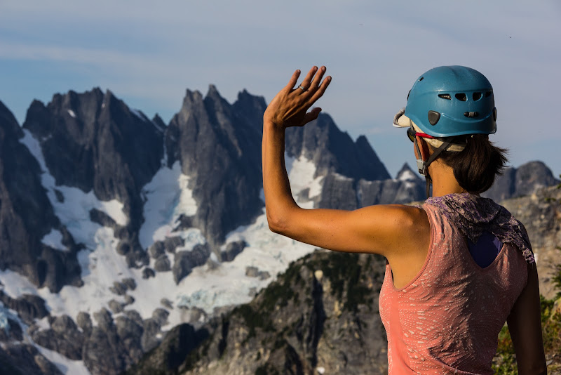
Seeing the photos of Carrie sunbathing on a rock slab or standing in Luna Lake, I have to say that you are a lucky, lucky man. Actually, you have great photos of Carrie throughout the report, both in action and responding to the setting. I tend to forget to include the people in my photos.
I'm glad you found your happy place above Luna Lake. One of my own favorite moments was in that area. Somewhere above Luna Lake, I went out and napped on a rock slab in the sun with a stream flowing over the slab alongside me. When I awoke, I very gradually opened my eyes, to see the entire face of Luna Cirque slowly swim into focus and stand out magnificently spread out across from me. That image still stays vivid in my memory.
As beacons mountains burned at evening. J.R.R. Tolkien
As beacons mountains burned at evening. J.R.R. Tolkien
|
| Back to top |
|
|
Backpacker Joe
Blind Hiker

Joined: 16 Dec 2001
Posts: 23956 | TRs | Pics
Location: Cle Elum |
You guys are amazing. Fantastic pics.
"If destruction be our lot we must ourselves be its author and finisher. As a nation of freemen we must live through all time or die by suicide."
Abraham Lincoln
"If destruction be our lot we must ourselves be its author and finisher. As a nation of freemen we must live through all time or die by suicide."
Abraham Lincoln
|
| Back to top |
|
|
tmatlack
Member
Joined: 21 Aug 2007
Posts: 2854 | TRs | Pics
|
|
tmatlack
Member
|
Thu Sep 12, 2013 3:16 am |
|
|
Wow.
Awesome. I can't imagine that haul with bad hips.
Navy plane is an EA-6B Prowler jammer out of Whidbey NAS. Not sure which squadron. They are still in the fleet, but being phased out by the new Growler. Incredibly loud.
Tom
|
| Back to top |
|
|
peltoms
Member

Joined: 13 Jul 2006
Posts: 1760 | TRs | Pics
Location: Worcester MA |
|
peltoms
Member
|
Thu Sep 12, 2013 5:26 am |
|
|
Best trip report of the summer. Thanks for image of Challenger glacier terminus.  
|
| Back to top |
|
|
Dect6
Member
Joined: 27 Mar 2011
Posts: 162 | TRs | Pics
|
|
Dect6
Member
|
Thu Sep 12, 2013 6:50 am |
|
|
Thanks for sharing this wonderful report. Love the pictures.
|
| Back to top |
|
|
Jim Dockery
Member

Joined: 12 Sep 2007
Posts: 3092 | TRs | Pics
Location: Lake Stevens |
One of the best TRs of the summer! So many excellent shots You guys lucked out with the weather. I haven't been in there for about 34 years, might have to go back someday soon, but since I've already climbed Challenger and Fury I'd leave the gear and just hike (and photograph).
|
| Back to top |
|
|
RichP
Member

Joined: 13 Jul 2006
Posts: 5634 | TRs | Pics
Location: here |
|
RichP
Member
|
Thu Sep 12, 2013 7:57 am |
|
|
You guys have done some fantastic trips together, but this one really stands out. Thanks for showing us the ups and downs of a place most of us will never see in person.
Your photos of the impasse made me break out in a sweat.
|
| Back to top |
|
|
olderthanIusedtobe
Member
Joined: 05 Sep 2011
Posts: 7709 | TRs | Pics
Location: Shoreline |
| iron wrote: | | as we rounded the S end of lousy lake, i got to use up my 2nd cat's life. we were walking level, on rocks of course, with about 5ft between myself and hotpantz. she was first, i was second. somehow, between us, a rock that i estimate at 3000lbs decided to topple over. i first saw it tilt backwards, somehow, and then just go a rumblin' down. because i drink milk, i still have quick reflexes (or so the commercials say). i was about 1/2 second from game over. |
I accidentally triggered a rockslide on a moraine earlier this summer. I don't think there were any 3000 lbers involved, but it easily could've ended up very badly for me. Glad you walked away unscathed.
|
| Back to top |
|
|
rbuzby
Attention Surplus
Joined: 24 Feb 2009
Posts: 1011 | TRs | Pics
|
|
rbuzby
Attention Surplus
|
Thu Sep 12, 2013 8:52 am |
|
|
Way to capitalize on the great weather.
|
| Back to top |
|
|
Bedivere
Why Do Witches Burn?

Joined: 25 Jul 2008
Posts: 7464 | TRs | Pics
Location: The Hermitage |
|
Bedivere
Why Do Witches Burn?
|
Thu Sep 12, 2013 9:04 am |
|
|
Helluva report! The pictures, the description, most excellent. Thanks!
|
| Back to top |
|
|
jboealps
Member
Joined: 10 Aug 2006
Posts: 71 | TRs | Pics
Location: Seattle |
|
jboealps
Member
|
Thu Sep 12, 2013 10:35 am |
|
|
Really enjoyed the great report and images.
We intend on going back via Easy Ridge and the II route information will be invaluable. Last time (1989), I did the descent to hell before climbing up to Perfect Pass.
Also great to see another couple climbing in the mountains.
|
| Back to top |
|
|
|
|
You cannot post new topics in this forum
You cannot reply to topics in this forum
You cannot edit your posts in this forum
You cannot delete your posts in this forum
You cannot vote in polls in this forum
|
Disclosure: As an Amazon Associate NWHikers.net earns from qualifying purchases when you use our link(s). |


