| Previous :: Next Topic |
| Author |
Message |
wesdyer
Member


Joined: 11 Jul 2011
Posts: 4 | TRs | Pics
|
|
wesdyer
Member
|
 Thu Sep 12, 2013 6:25 pm |
|
|
Short version:
Anyone have information about Iron Cap Mountain's east ridge? Beta or Pics?
Long version
I'm planning a trip on the Alpine Lakes High Route. The trip is supposed to be a scramble with some friends. Normally, the route from Tank Lakes to Chetwoot goes to Iron Cap Pass and then down a valley and up into Azurite and Azure lakes before going across to Chetwoot. Some parties choose to traverse under Iron Cap Mountain and then take the north spur which is a mellow scrambling route. I was hoping to take a more direct route via Iron Cap Mountain's east ridge, but I could find little information about the east ridge. Beckey doesn't mention it and I couldn't find any trip reports here or on other sites with distinct pictures of the east ridge.
Has anyone here been up that way? What is it like? Is it 3rd/4th/low 5th? Does anyone have any pictures?
Here is the east ridge seen from the NNE in Google Earth. It looks like it would go as a scrambling route, but...
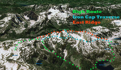 Alpine Lakes High Routes 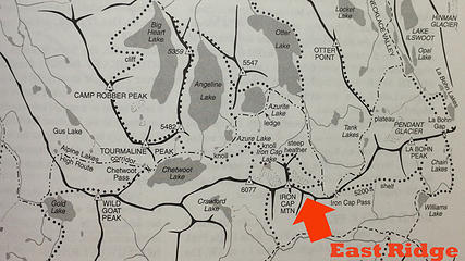 Alpine Lakes High Route
|
| Back to top |
  
|
|
rossb
Member

Joined: 23 Sep 2002
Posts: 1679 | TRs | Pics
|
|
rossb
Member
|
Thu Sep 12, 2013 6:59 pm |
|
|
I don't know for sure, but if I remember right, it is much better than the west ridge. I hiked in that area recently, and came in from the west. I started by climbing point 6077. I then followed the ridge to Iron Cap, based on a trip report I read. The authors of that report are way more tolerant of nasty, scary terrain than I am. I almost turned around, but rightly assumed that once I got there, I could find a better way down. I did (via the high route). The east ridge didn't look that great, but it didn't look horrible either.
I think you could do one of two things:
1) Follow the standard route.
2) Try the east ridge. If it gets hairy, then go down, then over. As you can see, eventually they would meet up anyway. In other words, if you can handle the first part, you can handle the rest. Unlike other routes (which are the opposite) you don't have much to lose in trying.
|
| Back to top |
|
|
filbert
Member
Joined: 31 May 2010
Posts: 99 | TRs | Pics
|
|
filbert
Member
|
Thu Sep 12, 2013 9:05 pm |
|
|
The west ridge is easy in comparison with the east ridge (at least the way I went). Unfortunately it was a long time ago - when I was still using film, so I don't have anything that I could show you. I did this as part of a overnight scramble, going up Necklace Valley and returning via the West Fork. Solo trip, just hoofed the extra two miles between THs. Guessing it was early August.
Most of this route is pretty easy. No problems with brush (I'd suffered badly trying this general route at lower elevation). There were a few places where I wished I had crampons as at that time there were a few areas with really hard snow. There are some gendarmes that you want to be sure to pass by, these are fairly obvious. There were some crevices in the ridge-line that were a bit hairy; most difficult was the final ascent near the top, which is short but quite steep. There may have been a better way. Again, this is much easier from the west. {Just to give you some way of evaluating these remarks: when I did this I'd gone through the Mounty scrambling course but hadn't yet done Basic Climbing}.
If you only want to bag the peak, I'd recommend the west ridge.
Either side is beautiful!
With every passing hour our solar system comes forty-three thousand miles closer to globular cluster M13 in the constellation Hercules, and still there are some misfits who continue to insist that there is no such thing as progress.
With every passing hour our solar system comes forty-three thousand miles closer to globular cluster M13 in the constellation Hercules, and still there are some misfits who continue to insist that there is no such thing as progress.
|
| Back to top |
|
|
wesdyer
Member
Joined: 11 Jul 2011
Posts: 4 | TRs | Pics
|
|
wesdyer
Member
|
Thu Sep 12, 2013 10:03 pm |
|
|
Sounds like it isn't more than 3rd class but it may have hard and somewhat steep snow.
|
| Back to top |
|
|
rossb
Member
Joined: 23 Sep 2002
Posts: 1679 | TRs | Pics
|
|
rossb
Member
|
Sun Sep 15, 2013 3:43 pm |
|
|
| wesdyer wrote: | | Sounds like it isn't more than 3rd class but it may have hard and somewhat steep snow. |
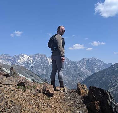
I would say so, although my guess is that the snow is gone. It turns out that I do have a picture looking that direction (from the top of Iron Cap). It isn't great, but it might be helpful.
You can see that once you get around the final bump, it is pretty easy sailing. I want to amend my previous statement, by the way; I can easily see how going that way could result in a "dead end", or time (and energy) wasted. Looking at the map, it seems like the easiest route is to traverse around 5400 feet or so, until you get into very moderate terrain NNE of the peak. Unfortunately, if you try following the ridge, and then decide it is too much trouble, you will probably change your mind when it gets tough, which is around 5800 feet. If you try traversing at that point, you will encounter cliffs (which are quite obvious on the map). So, if you do decide to abandon that approach, I would suggest just back tracking to around 5400 and traversing there. My guess is that you will end up doing that, even if you do so in a more unplanned manner (traverse -- hit cliffs -- descend -- traverse -- hit cliffs -- repeat until you are done).
|
| Back to top |
|
|
Schroder
Member

Joined: 26 Oct 2007
Posts: 6722 | TRs | Pics
Location: on the beach |
|
Schroder
Member
|
Sun Sep 15, 2013 4:04 pm |
|
|
Here it is from just above the pass
|
| Back to top |
|
|
puzzlr
Mid Fork Rocks

Joined: 13 Feb 2007
Posts: 7220 | TRs | Pics
Location: Stuck in the middle |
|
puzzlr
Mid Fork Rocks
|
Sun Sep 15, 2013 5:38 pm |
|
|
Thanks, rossb and Schroder. I'm heading this way in a week or so, as soon as the weather cooperates.
|
| Back to top |
|
|
wesdyer
Member
Joined: 11 Jul 2011
Posts: 4 | TRs | Pics
|
|
wesdyer
Member
|
Mon Sep 16, 2013 9:18 am |
|
|
Thanks for all the replies!
|
| Back to top |
|
|
zimmertr
TJ Zimmerman
Joined: 24 Jun 2018
Posts: 1228 | TRs | Pics
Location: Issaquah |
|
zimmertr
TJ Zimmerman
|
Mon Jul 15, 2019 5:06 pm |
|
|
|
| Back to top |
|
|
zimmertr
TJ Zimmerman
Joined: 24 Jun 2018
Posts: 1228 | TRs | Pics
Location: Issaquah |
|
zimmertr
TJ Zimmerman
|
Mon Jul 15, 2019 5:10 pm |
|
|
Thank you very much, it is greatly appreciated. I'm trying to piece together a route for this traverse and this will be a big help.
I intend to bring a friend from Michigan with me and he has 0 backpacking experience so I'm trying to discern the safest route across Iron Cap.
|
| Back to top |
|
|
neek
Member

Joined: 12 Sep 2011
Posts: 2338 | TRs | Pics
Location: Seattle, WA |
|
neek
Member
|
Mon Jul 15, 2019 5:48 pm |
|
|
This is roughly the line I recall taking between Iron Cap and Iron Cap Pass 8 years ago, but we weren't using GPS and it was some time ago so I could be a bit off. I don't think you'd want to go much higher than this along the east ridge due to the aforementioned gendarmes and cliffs, but I recommend not skipping the Iron Cap summit as some do. This was our decent btw since we were going ccw. It wasn't difficult but definitely the steepest part of the trip.
|
| Back to top |
|
|
puzzlr
Mid Fork Rocks
Joined: 13 Feb 2007
Posts: 7220 | TRs | Pics
Location: Stuck in the middle |
|
puzzlr
Mid Fork Rocks
|
Mon Jul 15, 2019 10:35 pm |
|
|
If you want to convince yourself not to try the east ridge go to https://gismaps.kingcounty.gov/iMap/ , turn on the 10' elevation contour layer and zoom into Iron Cap. There's no obvious easy route down the east ridge -- you'll hit cliffs right away. For calibration look at the west ridge with it's relatively wide 10' contours -- that's a normal scramble route that's not exposed, but climbs steadily.
|
| Back to top |
|
|
cfm
Member
Joined: 11 Aug 2013
Posts: 3 | TRs | Pics
|
|
cfm
Member
|
Sat Jul 20, 2019 7:38 am |
|
|
I was up there a few years ago, arrived at the little lake below Iron Cap via the traverse route indicated on your Google map. We ran into two exhausted fellows who had attempted the east ridge and were stymied by impassable terrain and not willing to do it without protection, had to backtrack and drop down to our route. 2015 Trip report
|
| Back to top |
|
|
scottk
Member
Joined: 09 Jul 2013
Posts: 47 | TRs | Pics
|
|
scottk
Member
|
Wed Jul 24, 2019 12:19 pm |
|
|
I think Neek's route probably works the best. I climbed Iron Cap last fall and rather than heading up when Neek's route heads up I kept contouring around the ridge to the north side before turning south and climbing to the summit of Iron Cap. It was steep and brushy traversing around the ridge and a pain in the butt. I didn't head up like Neek's route suggests because it looked brushy but it retrospect it probably would have been easier. I camped on ledges near the outlet of the lake northwest of the summit.
|
| Back to top |
|
|
|
|


