| Previous :: Next Topic |
| Author |
Message |
RodF
Member


Joined: 01 Sep 2007
Posts: 2593 | TRs | Pics
Location: Sequim WA |
|
RodF
Member
|
 Sun Oct 20, 2013 1:09 am |
|
|
For those who like history, and enjoy a bit of an off-trail scramble, here's an interesting dayhike near Port Angeles. It's about two hours hike from the trailhead, and is worth an hour or two of exploration once there.
Little River Trail, above Port Angeles, leads 8 miles up the south branch of Little River to Hurricane Hill. I've previously reported here the construction of two new footlogs on the trail. The first of these, 1.8 miles from the trailhead, spans Little River to its west bank at the mouth of Cowen Creek.
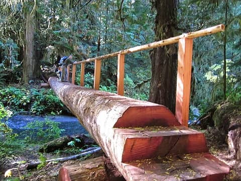 BCHW footlog at 1.8 miles 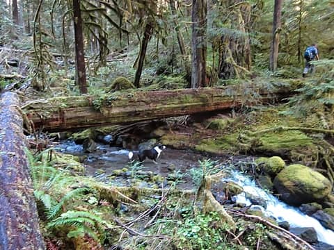 crossing Cowen Creek 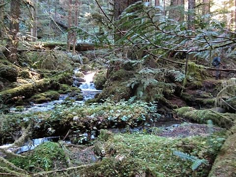 Cowen cascades 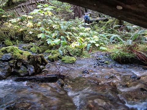 recrossing beneath big log 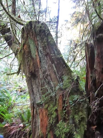 sawn stump with springpole notches below mine 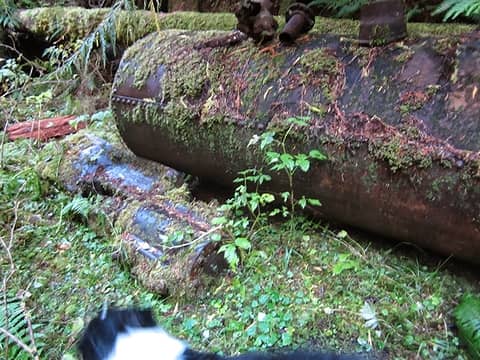 air compressor and tank 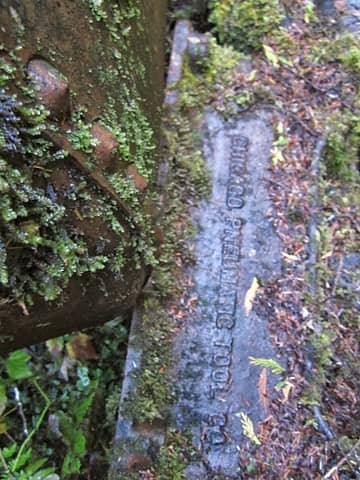 Chicago Pneumatic Tool Co. piston air compressor 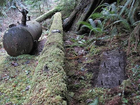 tank and compressor foundation 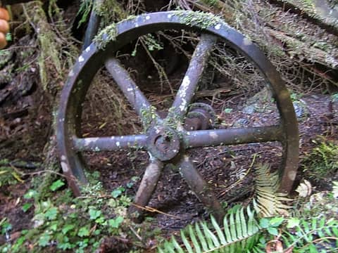 flywheel... 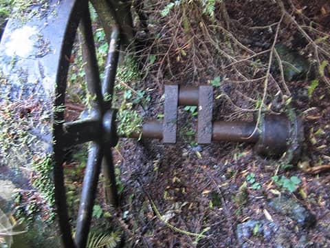 ...with crank to drive compressor 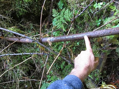 compressed air pipe 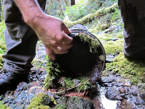 water pipe 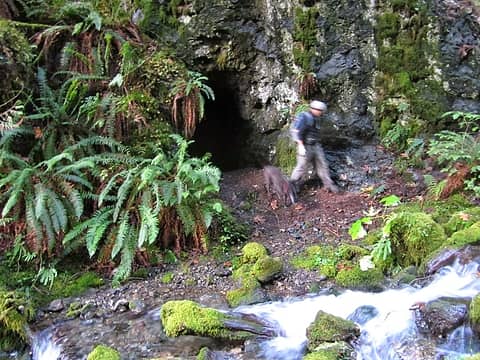 main shaft entrance 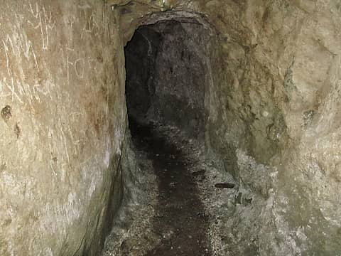 main shaft 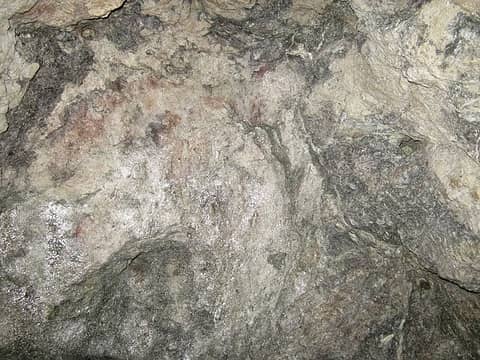 quartz vein at end of main shaft 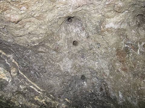 drill holes 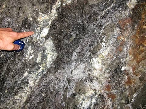 quartz 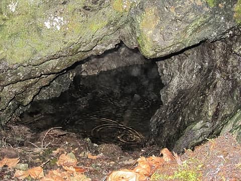 second shaft, on north bank 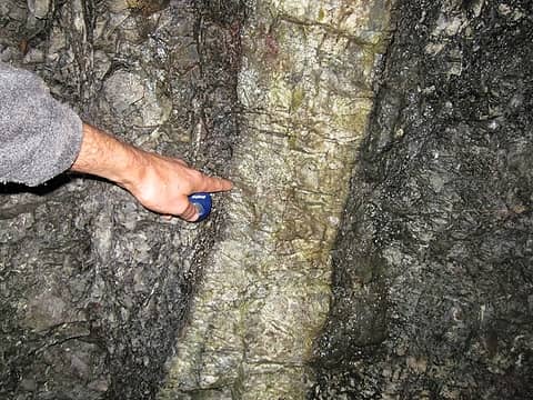 wide quartz vein
"of all the paths you take in life, make sure a few of them are dirt" - John Muir
"the wild is not the opposite of cultivated. It is the opposite of the captivated - Vandana Shiva
"of all the paths you take in life, make sure a few of them are dirt" - John Muir
"the wild is not the opposite of cultivated. It is the opposite of the captivated - Vandana Shiva
|
| Back to top |
  
|
|
H. Hound
Member

Joined: 09 May 2003
Posts: 1205 | TRs | Pics
Location: Exit 32 |
|
H. Hound
Member
|
Sun Oct 20, 2013 4:52 am |
|
|
Thanks for the report. I love finding stuff like that out in the woods. I checked the reference in "Inventory of Washington Minerals" part II "Metallic Minerals" for the Angeles Star, and it's listed as unpublished. Unpublished field notes can be viewed at the DNR library in Olympia if you want more info.
|
| Back to top |
|
|
haydenslides
Member
Joined: 23 Feb 2009
Posts: 78 | TRs | Pics
|
Motivated by your trip report, I made it up to the mines today! A little hint for anyone attempting the trek: as you work your way up the creek two creeks will flow into the main creek. At the first one stay left and at the second one stay right. There is a faint way trail up to the site but it disappears and crosses the creek numerous times...you are basically looking for the path of least resistance.
|
| Back to top |
|
|
trestle
Member

Joined: 17 Aug 2008
Posts: 2093 | TRs | Pics
Location: the Oly Pen |
|
trestle
Member
|
Tue Apr 24, 2018 10:36 pm |
|
|
Thanks RodF, another great walk back in time.
"Life favors the prepared." - Edna Mode
"Life favors the prepared." - Edna Mode
|
| Back to top |
|
|
MyFootHurts
Huge Member

Joined: 22 Nov 2011
Posts: 912 | TRs | Pics
Location: Kekistan |
Went 4 miles mile up the Little River trail today to about the 2000' level.
Couldn't find the mine trail. I think I was looking in the right place, just too much brush and undergrowth.
|
| Back to top |
|
|
RodF
Member
Joined: 01 Sep 2007
Posts: 2593 | TRs | Pics
Location: Sequim WA |
|
RodF
Member
|
Fri May 24, 2019 11:06 am |
|
|
| MyFootHurts wrote: | | Went 4 miles mile up the Little River trail today to about the 2000' level.
Couldn't find the mine trail. I think I was looking in the right place, just too much brush and undergrowth. |
Standing on the footlog over south branch Little River pictured above, you'll see the confluence of Cowen Creek within 100 feet downriver. Stepping off the footlog onto the trail on its west bank, walk about 75 feet upriver to the campsite with fire ring. Turn right and walk through the campsite to its SW corner. The way trail climbs west out of the campsite. It initially gains about 15 feet in elevation above the south bank of Cowen Creek. In about 500 feet, it crosses on a big log to the north bank and continues up Cowen Creek.
The way trail is noticeably more trodden and easier to follow than when I first posted this topic.
Opinion: Although some object to sharing it, I felt this site enrichens our appreciation of the area's history before it was a Park, and our appreciation of its preservation as a Park since. It shouldn't be hidden, known only to a few, or erased as most mines, homesteads, ranger stations and shelters within the Park have been. Think of all the work put into building trail and cabins, hauling the Pelton wheel, compressor, water and air pipes and carving those tunnels a century ago!
"of all the paths you take in life, make sure a few of them are dirt" - John Muir
"the wild is not the opposite of cultivated. It is the opposite of the captivated - Vandana Shiva
 Hiking addict Hiking addict
"of all the paths you take in life, make sure a few of them are dirt" - John Muir
"the wild is not the opposite of cultivated. It is the opposite of the captivated - Vandana Shiva
Hiking addict
|
| Back to top |
|
|
MyFootHurts
Huge Member
Joined: 22 Nov 2011
Posts: 912 | TRs | Pics
Location: Kekistan |
Yeah that's about where I looked. Guess it was just obscured by the spring foliage.
|
| Back to top |
|
|
Stumblefoot
Stumblefoot
Joined: 29 Oct 2017
Posts: 13 | TRs | Pics
Location: Port Angeles |
If you were 4 miles in then you were way too far. I believe it is only about 2 miles from the trail head to Cowen creek. I was up there last fall and made some small blazes marking the way trail. I agree that sites like this shouldn't be lost to history, or known only to a few. If the park service refuses to or is unable to maintain these trails then all that will keep them from disappearing into the brush is more usage.
|
| Back to top |
|
|
Hiking addict
Cooper Warpula

Joined: 07 Mar 2022
Posts: 134 | TRs | Pics
Location: Keyport Washington |
I made an account so I could give an update on Gregory Mines. I went there January 22 2022 and did make it up to them. Your directions were very accurate even 8 years later. We were afraid we would not notice Cowen Creek downstream from the bridge but we did easily. The way trail is good for the first half of the way there. Unfortunately, the attachments to the top of the piston air compressor have been stolen, however its not spray painted or moved. We managed to find 6 mineshafts in total and 5 upstream from the main one. We found the mine above the tailings on the north bank, but we never found the flooded mine. We didnt have boots anyway. We kept exploring upstream and found two shafts on the south bank right next to the creek similar to the main mine that only they went back only about ten feet, however upstream is where all the relics are. We found a very hidden mine on the north bank very close to the creek that was obscured by the foliage that I literally stumbled into while walking the bank, I was unhurt. It went back 5 feet. We made it up to a confluence which split the creek in half. You should be able to tell on a map. This is where we stopped, but I think there are many more mines to find including ones that go back far. I have a trip report of this on WTA if you want to see it. I have already inspired someone to retrace my steps and they too put up a trip report. Thank you so much for sharing this trip report to all of us. It was really a walk through time over 100 years ago. I will come back here one day, to explore the mines high above the south bank we didnt locate. And to clear the blowdowns and do some flagging. Not to mention bring boots to explore the flooded mine and perhaps a hammock for an overnight.
To have a good life, you need to take risks.
RodF
To have a good life, you need to take risks.
RodF
|
| Back to top |
|
|
Hiking addict
Cooper Warpula
Joined: 07 Mar 2022
Posts: 134 | TRs | Pics
Location: Keyport Washington |
To have a good life, you need to take risks.
|
| Back to top |
|
|
Hiking addict
Cooper Warpula
Joined: 07 Mar 2022
Posts: 134 | TRs | Pics
Location: Keyport Washington |
To have a good life, you need to take risks.
|
| Back to top |
|
|
Hiking addict
Cooper Warpula
Joined: 07 Mar 2022
Posts: 134 | TRs | Pics
Location: Keyport Washington |
Here are some extra details about my trip. Directions are very accurate even after 8 years. A very large contributary creek with a small valley enters from the south(left) at 0.3 miles marking the halfway point. Keep right on the main creek. There is another small creek that enters the valley from the north at 0.5 miles is just past the air compressor and has a really beautiful cascade. The people in the youtube video scramble up to it at the end of the video. The cascade is an indication you are so close to Gregory mine on the other side of the creek from the falls(the south side). The main mine is obvious. Just past the main mine, there is an unnatural scree from two mines that are really high on the south bank. We tried to locate them but we didn't have the time and I climbed up the slope for 200 feet above the creek when I decided that it was too steep. Located just across the stream from the unnatural scree you will find the flooded mine. I suggest you bring boots to explore the flooded mine We didn't find it on our trip but we know where it is in relation to the scree because of the video. Looking from the south bank across the scree you will see another mine high on the north bank. We explored this shaft. It only went back about 25 feet and was hard to get to. But it was worth it for us. Two more mineshafts right on the bottom of the creek ravine about 300 to 400 yards upstream located on the south bank go back about 15 feet. One of which had red tape laying on the ground at the entrance. I'm not sure what it was but the rubber red tape almost looked like the outer cover for a dynamite stick. There are lots of iron slinky pipes in the creek here and random peices of metal. On the north bank not far from the two other shafts is another shaft that goes back about ten feet. It's so hidden and so interesting. Looking out of the mine the creek is right in your face. Then, the creek splits into two and it looks like there are additional mines beyond this confluence. We stopped here and turned around. If you go beyond this spot let me know what you find! If you have any questions then just ask. 
To have a good life, you need to take risks.
RodF
To have a good life, you need to take risks.
RodF
|
| Back to top |
|
|
Hiking addict
Cooper Warpula
Joined: 07 Mar 2022
Posts: 134 | TRs | Pics
Location: Keyport Washington |
Tomorrow I am going to Crescent Mine near lake Crescent. It dates back to 1923 or 99 years ago and apparently goes back several thousand feet. Theyre are so many adits( mine portals) and lots of relics. I will post a report about it. It will be really interesting, I you want to know more than click the link http://exploreolympics.com/reports/?p=8345
To have a good life, you need to take risks.
To have a good life, you need to take risks.
|
| Back to top |
|
|
Hiking addict
Cooper Warpula
Joined: 07 Mar 2022
Posts: 134 | TRs | Pics
Location: Keyport Washington |
To have a good life, you need to take risks.
|
| Back to top |
|
|
|
|
You cannot post new topics in this forum
You cannot reply to topics in this forum
You cannot edit your posts in this forum
You cannot delete your posts in this forum
You cannot vote in polls in this forum
|
Disclosure: As an Amazon Associate NWHikers.net earns from qualifying purchases when you use our link(s). |


