| Previous :: Next Topic |
| Author |
Message |
Slide Alder Slayer
Member


Joined: 14 Jan 2002
Posts: 1960 | TRs | Pics
|
Looking to spend a full day hiking without the drive home, Pack Pup and I checked into Leavenworth’s Roadway Inn early Friday mourning 6/27/03, and after a quick dash to the ranger station headed out to hike Lake Stuart and Horseshoe Lake. Approximately one-half mile after crossing Icicle Creek on road 7601, a mother black bear and her new cub bounded across the road fifty feet in front of us. Mom and baby were headed down hill, and true to her nature, she stopped just across the road to get a good look at us before proceeding on her way.
The trail to Lake Stuart is in excellent condition. Pack Pup and I took a break at the “rock” located on the Western shore and watched two fathers who were camped near by teaching their young daughters the fine art of fishing.
The trail to Horseshoe Lake is another matter. The first half mile until the large log that crosses the stream is not too bad, just a lot of downed trees, but the trail is dry. (After crossing this stream stay left, another social trail goes right and I am unfamiliar with its’ destination.) From the stream to where the horseshoe is carved into the tree and the fisherman’s trail ascends to the lake, is a path, faint at times, that is covered with downed trees and tracks across the marshy meadow at several locations. The fisherman’s path to Horseshoe Lake is pretty much straight up and often right next to or into the outlet stream. The path, and I am being generous here, stays to the NE side of the stream, your left, until approximately one third mile below the lake where it is easily crossed. Immediately after crossing we encountered a few snow patches until the final steep 100 yards where we kicked stepped our way to the top.
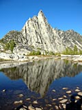
The Horseshoe Lake basin is a beautiful area covered with larches and outstanding views, especially of Mount Stuart and Sherpa Peak. Current conditions have the Eastern portion of Horseshoe Lake sixty percent iced over with the remainder of the lake eight-five to ninety percent frozen. The Eastern portion of the basin appears to be about fifty percent snow covered and that percentage increases as one looks West. We took our break at the Eastern section of the basin and snow depth there was at most was one to two feet.
While there are probably ten ways a mountain can get to this area, the official Colchuck/Stuart trailhead will close July 14th at 12:01 AM. Between now and then be aware that there is a recent mosquito hatch and that steep portions of the “trail” to Horseshoe are slippery, especially on the way down.
|
| Back to top |
  
|
|
Odonata
Member

Joined: 14 Aug 2002
Posts: 306 | TRs | Pics
|
|
Odonata
Member
|
 Sun Jun 29, 2003 2:21 pm |
|
|
That there Horseshoe lake is a real pretty place Mr. Slide Alder Slayer. I remember going up the rockslide on the left and kind of hooking to the right to the lake in early October. We took the trail down. My tarp tent got a real workout with some high wind at night. There are some interesting "sand pits" around the area that lend themselves well to low impact camping. I still drool looking at my pictures from 5 years ago. Thanks for the report. -Dave
|
| Back to top |
|
|
Dayhike Mike
Bad MFKer
Joined: 02 Mar 2003
Posts: 10955 | TRs | Pics
Location: Going to Tukwila |
My dad and I like to make a loop of the hike to Horseshoe (when we're going expressly there and not making the Mountaineer Creek / Goat Pass / Horseshoe Lake traverse) because that "trail" you took up is not bad for coming down, but a piece of crap for going up...
Here's the route...at the end of the valley, *don't* go up the direct route...continue on to the talus slope and veer right and up. Follow the cairns up the talup slope to where to the valley headwall where the rock meets shubbery. You'll find a path up next to a hanging valley.
Walk through this meadowy bowl and start climbing up another talus slope and as soon as you are able to get above the rocky, cliffy bands on your right, take a hard right and voila! welcome to our "Eden"...beautiful cool streams flow through lush mossy banks and smaller trails wind throughout.
From here, head uphill, directly toward Horseshoe. Pick a rocky ridge and follow it right on up and over to your awaiting destination.
Regarding the descent...the top is gorgeous when not under snow...another band of meadows on a bench of earth... And the trail is one of the most interesting -- steep, steep, steep; cool footholds and "steps" using little ledges in the rocks, and really only gets ugly as you near the bottom and have to wind in and out of snags by Horseshoe's outlet creek. Just don't use it to go up.
"There is only one basic human right, the right to do as you damn well please. And with it comes the only basic human duty, the duty to take the consequences." -P.J. O'Rourke
"Ignorance is natural. Stupidity takes commitment." -Solomon Short
"There is only one basic human right, the right to do as you damn well please. And with it comes the only basic human duty, the duty to take the consequences." -P.J. O'Rourke
"Ignorance is natural. Stupidity takes commitment." -Solomon Short
|
| Back to top |
|
|
Studebaker Hoch
Member
Joined: 04 Jul 2013
Posts: 463 | TRs | Pics
Location: eastside |
haha wish I had read this report before trying to go to Horseshoe lake in August.
We took the right hand "social trail" after the stream crossing. We followed it for about 60 yards before running into several bee/wasp things nests and getting stung a bunch of times. I think it would eventually just link up with the main trail to HS near the bench just below the final ascent to the lake. (10 years later the mystery of this trail has been solved!)
STAY LEFT! There are many trees in the way but once you get to the meadows its a bit easier to follow, just stay near the edge of the trees till you find the horseshoe.
|
| Back to top |
|
|
tigermn
Member

Joined: 10 Jul 2007
Posts: 9242 | TRs | Pics
Location: There... |
|
tigermn
Member
|
Mon Nov 25, 2013 11:26 am |
|
|
|
| Back to top |
|
|
|
|
You cannot post new topics in this forum
You cannot reply to topics in this forum
You cannot edit your posts in this forum
You cannot delete your posts in this forum
You cannot vote in polls in this forum
|
Disclosure: As an Amazon Associate NWHikers.net earns from qualifying purchases when you use our link(s). |


