| Previous :: Next Topic |
| Author |
Message |
Ski
><((((°>


Joined: 28 May 2005
Posts: 12832 | TRs | Pics
Location: tacoma |
|
Ski
><((((°>
|
 Sat Dec 26, 2020 9:26 pm |
|
|
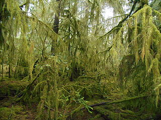 Pt. Defiance 122620 01
"I shall wear white flannel trousers, and walk upon the beach.
I have heard the mermaids singing, each to each."
"I shall wear white flannel trousers, and walk upon the beach.
I have heard the mermaids singing, each to each."
|
| Back to top |
  
|
|
meck
Member

Joined: 31 Dec 2010
Posts: 920 | TRs | Pics
|
|
meck
Member
|
Tue Dec 29, 2020 11:16 pm |
|
|
A fun afternoon visit to the Kitsap County Highpoint (Gold Mtn, SE of Green Mtn). I'd been to the antenna farms a couple of times before, but somehow missed the actual highpoint, so I finally visited it. Several antenna maintenance service vehicles passed me on the way up and down. Lots of names in the logbook (including several from here).
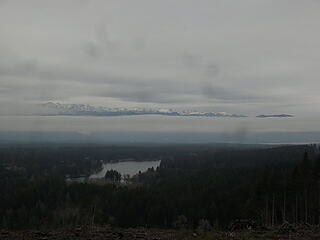 3 labels a view of the lower half of the eastern Olys. 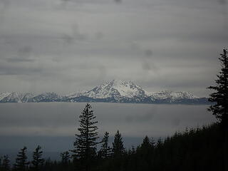 the Brothers 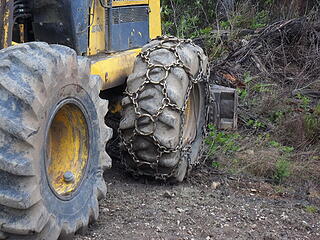 now those are what I call tire chains! 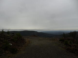 a view NW from logging road clearcut (Green Mtn summit is to the left out of frame) 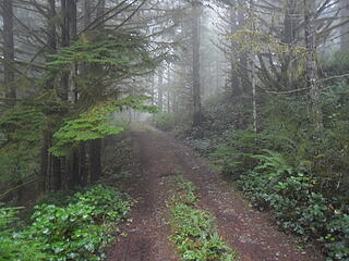 nearing the turnoff to the wooded summit (the antenna farms and clearcuts along the road provide better views) 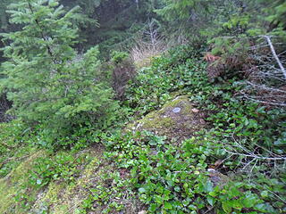 one of the two summit medallions 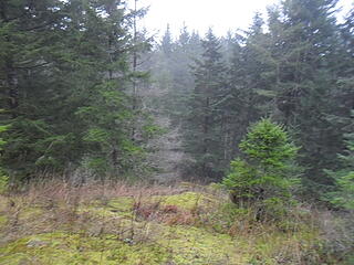 view from the summit.
*Just say NO to Rent-Seeking, don't give up the concept of "ownership"*
*Just say NO to Rent-Seeking, don't give up the concept of "ownership"*
|
| Back to top |
|
|
Jc21088
Jarred
Joined: 18 Jan 2021
Posts: 1 | TRs | Pics
Location: Seattle |
|
Jc21088
Jarred
|
Mon Jan 18, 2021 12:40 pm |
|
|
Summit Lake and Bearhead attempt:
Road is rough due to active logging operations. I wouldn't attempt without a vehicle with some clearance. Road is heavily snow covered and rutted about a half mile from the split to Coplay Lake. A 4/AWD, high clearance vehicle needed to reach this point. We parked here and walked the rest of the way. The road becomes steep, narrow, and remains heavily snow covered and rutted beyond this point. A lifted vehicle with large tires could probably make it to the parking lot, but attempt at your own risk and I would advise having chains for the way down due to ice.
Trail is snow covered the entire way, but well packed. The snow is firm due to recent rain/ice, so snowshoes not need. I would recommend spikes since the trail is fairly icy in spots, particularly on some forested sections with ice just before Twin Lake. There is a stream crossing at the Twin Lake outlet that requires a climb down from the high snow, crossing through water, and then a climb back up the other side. Not sure if there was a snow bridge here previously, but we decided not to cross. Attempted to head up to Bearhead, but it was a bit too icy to make it up the steep climb. There is a faint trail to follow and on a warmer day it wouldn't be too difficult.
|
| Back to top |
|
|
awilsondc
Member

Joined: 03 Apr 2016
Posts: 1324 | TRs | Pics
|
Mount Saint Helens Worm Flows 1/23/21
Third time up for me, but first winter ascent. We were expecting icy conditions and we got them. My friend left his snowshoes in the vehicle, but I brought mine just in case. We used them only to sit on at the crater rim (didn't need them). Crampons were essential. We skipped the true summit since we had been there before and didn't really feel like heading over. There was a fairly obvious cornice crack at the summit rim 10-15 feet from the rim. We were passed by 2 groups of 2 on their way to the true summit while he had lunch at the rim, otherwise we had the summit area to ourselves, a rarity for this peak. Plenty of people on the mountain though, somewhere in the 100-200 range I'd guess. Conditions were not good for glissading so we had to walk down. 4 hours up, 2:20 down.
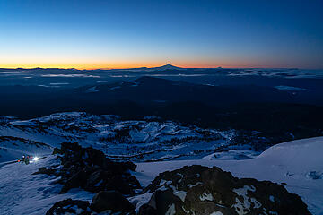 dawn 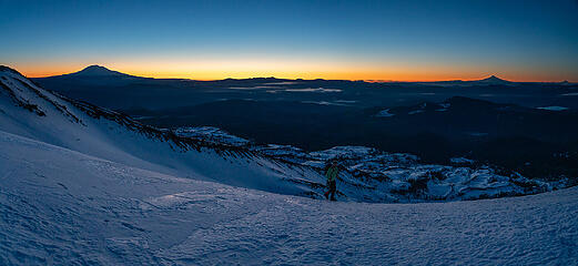 reaching the weather station 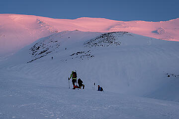 first light 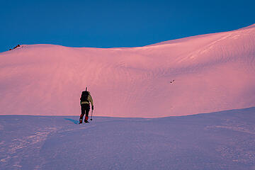 layers 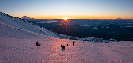 sunrise 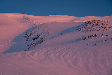 crater rim in sight 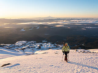 taking a break 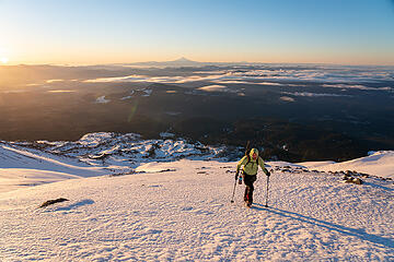 sun! 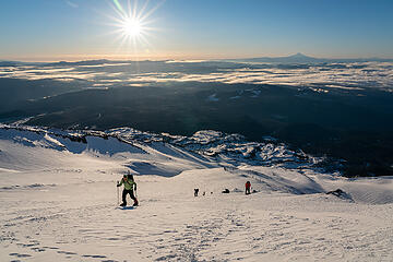 nearing the final push 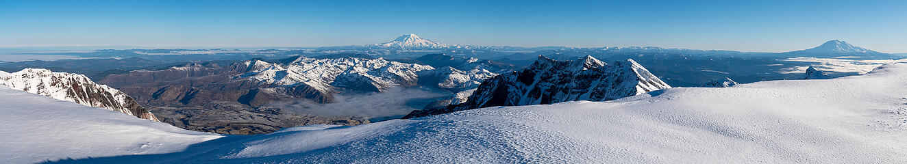 crater rim pano 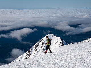 descending
|
| Back to top |
|
|
timberghost
Member
Joined: 06 Dec 2011
Posts: 1331 | TRs | Pics
|
|
| Back to top |
|
|
KascadeFlat
Member
Joined: 06 Jul 2020
Posts: 318 | TRs | Pics
Location: Eating peanut M&Ms under my blue tarp |
A January visit to a less-traveled corner of the ALW. It rained on us until 2800 ft when we hit consistent snow. The lake shore brought chilly wind and more snow. The snow balled up in our micro spikes as we climbed the NW ridge towards the upper lake. There was only 1-2in of snow on the ridge which made for beautiful and fun hiking. The snow gradually got deeper and we bailed at 4000 ft to retreat back to the lake for photos and snacks before heading home.
For a good time call: 1-800-SLD-ALDR.
For a good time call: 1-800-SLD-ALDR.
|
| Back to top |
|
|
cascadeclimber
Member

Joined: 04 Sep 2006
Posts: 1427 | TRs | Pics
|
Si on Sunday, Feb 14, post snow storm.
Snow from the parking lot up- was dry and increasingly deep. Much less snow in North Bend than we got in Issaquah- a foot or less until the basin past the boulders, except where wind-blown.
No one had traversed the basin over to the bench below the Haystack scramble since the storms, so that was a wallow.
I expected much more snow on the scramble. I find it most difficult when there's just enough snow/ice to fill in the edges, cracks, and other hand and footholds, and not enough to cover the slopey rock. A water-ice encapsulated tree was my first clue that it was going to be okay- there was a considerable crust on most of the snow in the gully that made for good cramponing. The step across the gap on the left variation is still spicy, especially on the way down. The last bit above the notch was all soft snow, but it's more scary looking than difficult.
Microspikes for the trail up (bare-booted down just fine), crampons and one tool for the scramble. Lots of layers- it was cold at the top.
|
| Back to top |
|
|
Malachai Constant
Member

Joined: 13 Jan 2002
Posts: 16092 | TRs | Pics
Location: Back Again Like A Bad Penny |
Did a Squak traverse Saturday from our house in Issaquah with about 6. Wore Costco imitation yak tracks as much was on asphalt. Walked up to Mountainside trailhead then up Bullet Fireplace Trail. Turned onto Central Peak trail to towers 12 on top. Had hot tea and snack. Down service road to Summit Trail. Glissade down to East Ridge Trail to East Access Trail. Then up streets to house. 7 miles and 2200 gain. When we arrived home 2 more snow had fell to 12 by night. We saw 2 couples on trail. Virgin snow on many of the trails. We did a similar traverse on track skis in 2019 in more snow but will not try that again.
"You do not laugh when you look at the mountains, or when you look at the sea." Lafcadio Hearn
"You do not laugh when you look at the mountains, or when you look at the sea." Lafcadio Hearn
|
| Back to top |
|
|
timberghost
Member
Joined: 06 Dec 2011
Posts: 1331 | TRs | Pics
|
Any pictures of your excursion? Did you have to make a campfire to warm up
|
| Back to top |
|
|
puzzlr
Mid Fork Rocks

Joined: 13 Feb 2007
Posts: 7220 | TRs | Pics
Location: Stuck in the middle |
|
puzzlr
Mid Fork Rocks
|
Wed Feb 17, 2021 3:20 pm |
|
|
Mailbox on Tuesday, 02/16. The three of us were the only ones on the peak as far as we could tell. Mailbox is buried for the first time in a few years.
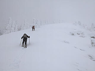 nearing summit 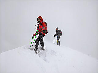 top 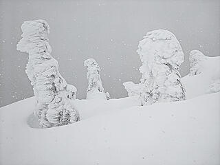 plastered trees 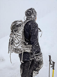 plastered pack
|
| Back to top |
|
|
timberghost
Member
Joined: 06 Dec 2011
Posts: 1331 | TRs | Pics
|
|
| Back to top |
|
|
cascadeclimber
Member
Joined: 04 Sep 2006
Posts: 1427 | TRs | Pics
|
Mailbox Sunday. Started up around 11:00 after waiting a few minutes for a parking spot (the upper lot gate is closed). I was surprised to find so much snow at the trailhead.
The temp when I left Issaquah was about 48. Trailhead temp was 40. That's an unusual difference.
The trail was slushy and slippery in places, but not icy- temps seemed isothermal until I got to treeline. Just one pair of other folks there and I added a layer and put on goggles before going out into the wind and driving rain and freezing rain.
The switchback trail in the boulders is obliterated. I follow a set of track starting directly up the boulders, but that one person turned around shortly after leaving the trail. From there to the top I was mostly breaking trail. The wind, as usual, was strongest on the boulder field. Gusts stopped me in my tracks multiple times.
Above the boulders and around the corner, there were deep drifts- knee to mid-thigh. Never seen them that big there. It was arduous getting to the top- trying to see the trail where the old snow was packed down under the new snow for less postholing. I erred to the right on the first, longer pitch to stay off the broader open area. The snowpack there is deep and water-soaked to the ground. Areas I punched through I could see plain slush down deep. Most of it has a medium surface crust.
Vis was poor. Up higher I was careful to stay climber's right as I suspect that cornices have now formed to the left. I didn't stop at the top- pirouetting and immediately starting down, with cold, cold rain being driven through my softshell pants and running down my jacket into my gloves.
Goggles. I don't remember when I started tossing a pair of clear ski goggles in my pack for Mailbox in winter, but they are invaluable. The wind tends to be out of the south/southwest and so blows right into your face on the descent.
In the deep drifts just before turning the corner to the boulders I noticed the Snowline walking crampon had come off my left foot. I was not about to turn around to look for it. It was kind of an interesting experience getting back down with just one, but the softer snow meant it wasn't awful. I cratered once, at the very last switchback before the flats, right after thinking, "this corner could be slippery and is the last place I could fall today." Hah.
Back at the car, the full lot had winnowed to three cars. I put on dry clothes and snuck in a Cable Line before heading home.
Excellent day of Type 2 fun on Mailbox. Nice to have some solitude up there.
|
| Back to top |
|
|
zephyr
aka friendly hiker

Joined: 21 Jun 2009
Posts: 3370 | TRs | Pics
Location: West Seattle |
|
zephyr
aka friendly hiker
|
Wed Mar 03, 2021 8:17 pm |
|
|
Dutch Miller Gap trail as far as Goldmyer. Wednesday, March 3, 2021. (No photos.)
Well, I made it to the Middle Fork. It was a beautiful day. The river was resplendent and the surrounding peaks were stunning against that blue sky. The main paved road was in fine condition all the way to the Taylor River bridge where one had to navigate around big piles of slush and icy potholes. The the drive along FR 5620 was a real adventure. Snow, compact and frozen in the morning, then deep and slushy in the afternoon covered the last four or so miles.
The various washouts were their usual selves and weren't too difficult if you go slow and choose your angle of entry and exit. One of the worst washouts was in the beginning near that area where they store cut logs, piles of gravel, and rock. It's small in width, but very deep. I just don't remember that one from last year.
The parking lot at Dingford Creek was covered in snow--fairly deep in the middle. I hiked along the Dutch Miller Gap trail as far as the turn-off for Goldmyer Hot Springs. I didn't see any tracks going further up that trail. But the snow was fairly deep all the way from Dingford along that road/trail. I would say at least 1-1.5 feet. The hiking was fairly easy in the morning, but the return was more challenging as it became a post-hole fest. Trekking poles were very useful. I only saw a few other people on the Forest road--three hikers, then a few vehicles, two cyclists, and one motorcyclist.
This time of year all the alders, maples, and other deciduous trees are bare and lots of sun illuminates that trail and the river. The river itself was beautiful, clear, and colorful in places.
~z
|
| Back to top |
|
|
timberghost
Member
Joined: 06 Dec 2011
Posts: 1331 | TRs | Pics
|
|
| Back to top |
|
|
zephyr
aka friendly hiker
Joined: 21 Jun 2009
Posts: 3370 | TRs | Pics
Location: West Seattle |
|
zephyr
aka friendly hiker
|
Wed Mar 03, 2021 11:02 pm |
|
|
| timberghost wrote: | | Pictures? |
Sorry. They're in my head.  This is more of conditions report. ~z This is more of conditions report. ~z
|
| Back to top |
|
|
|
|
You cannot post new topics in this forum
You cannot reply to topics in this forum
You cannot edit your posts in this forum
You cannot delete your posts in this forum
You cannot vote in polls in this forum
|
Disclosure: As an Amazon Associate NWHikers.net earns from qualifying purchases when you use our link(s). |


