| Previous :: Next Topic |
| Author |
Message |
zimmertr
TJ Zimmerman

Joined: 24 Jun 2018
Posts: 1224 | TRs | Pics
Location: Issaquah |
|
zimmertr
TJ Zimmerman
|
 Wed Apr 27, 2022 9:59 pm |
|
|
First paintbrush I've seen this year on a dumpster 90 mountain
|
| Back to top |
  
|
|
Comma
Member

Joined: 07 Oct 2012
Posts: 51 | TRs | Pics
|
|
Comma
Member
|
Wed Apr 27, 2022 11:08 pm |
|
|
I normally post my trip reports on WTA but Ravensbeak is not on there, and I think it's worth writing about somewhere because it's so rarely climbed.
I've had my eyes on Ravensbeak in the Middle Fork for about a year now, and finally did it on Saturday after scouting it out the previous week. The going was slow when I got out of the creek basin and up the ridge leading to the saddle between the Pulpit and Ravensbeak. I mostly followed the information I gleaned from here. Conditions were not ideal - rapidly melting wet snow on steep terrain. Lots of veggie belaying happened. Ice axe was not strictly necessary but being able to self belay made the small gully leading to the summit much easier. I did not find the summit register, but did not want to spend a bunch of time digging around in the snow. Coming back down was about as painful as coming up, and involved lots of slipping and falling and tumbling. In summer, this would be a very steep class 2+/3- that involves veggie belays and a somewhat exposed very short scramble just below the summit, in winter probably a class 3.
 ozzy, Now I Fly, puzzlr, ALW Hiker, LukeHelgeson, Fedor, awilsondc, mosey ozzy, Now I Fly, puzzlr, ALW Hiker, LukeHelgeson, Fedor, awilsondc, mosey
ozzy, Now I Fly, puzzlr, ALW Hiker, LukeHelgeson, Fedor, awilsondc, mosey |
| Back to top |
|
|
jaysway
Member

Joined: 16 Jul 2020
Posts: 347 | TRs | Pics
|
|
jaysway
Member
|
Thu Apr 28, 2022 4:23 pm |
|
|
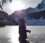
I hiked Coyote Wall in the Gorge yesterday evening after work and stayed through sunset. This was my first hike in over six months, although I have done a fair amount of skiing since then. Of the dozen total people we saw, over half were mountain biking, some with dogs which was neat to see. This was also my first time using my real camera in many months, but since it takes me time to process and go through those pictures these are ones from my iPhone.
Anne Elk, Fedor, Roy Jensen, half fast, awilsondc
Anne Elk, Fedor, Roy Jensen, half fast, awilsondc |
| Back to top |
|
|
zephyr
aka friendly hiker

Joined: 21 Jun 2009
Posts: 3370 | TRs | Pics
Location: West Seattle |
|
zephyr
aka friendly hiker
|
Thu Apr 28, 2022 7:23 pm |
|
|
Wow. What a fun trip that was. So many beautiful photos. Hard to pick one.
I'll try. ~z
But wait... This one. The light is awesome. Those rock formations. Oooh.
jaysway
jaysway |
| Back to top |
|
|
RichP
Member

Joined: 13 Jul 2006
Posts: 5634 | TRs | Pics
Location: here |
|
RichP
Member
|
Wed May 11, 2022 1:13 pm |
|
|
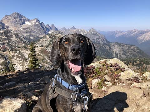
I biked up Three Lakes Hill from the DNR gate at the end of 89th St SE north of Monroe today. I met this guy on the way and he followed me all the way to the top and back down (more than 10 miles). I thought he might be from one of the houses in the area but he sure wanted to jump in the car with me when we got back down. Super friendly dog and I hope he's not lost.
|
| Back to top |
|
|
zephyr
aka friendly hiker
Joined: 21 Jun 2009
Posts: 3370 | TRs | Pics
Location: West Seattle |
|
zephyr
aka friendly hiker
|
Wed May 11, 2022 1:23 pm |
|
|
| RichP wrote: | | I biked up Three Lakes Hill from the DNR gate at the end of 89th St SE north of Monroe today. I met this guy on the way and he followed me all the way to the top and back down (more than 10 miles). I thought he might be from one of the houses in the area but he sure wanted to jump in the car with me when we got back down. Super friendly dog and I hope he's not lost. |
Awww, Geez. I hope he finds his family.  Sounds like an awesome doggy. No collar/tags? ~z Sounds like an awesome doggy. No collar/tags? ~z
|
| Back to top |
|
|
RichP
Member
Joined: 13 Jul 2006
Posts: 5634 | TRs | Pics
Location: here |
|
RichP
Member
|
Wed May 11, 2022 1:33 pm |
|
|
He had a collar but no info on it. Neutered and well-cared for so he might belong to one of the neighbors.
|
| Back to top |
|
|
Now I Fly
Member
Joined: 07 Jun 2018
Posts: 465 | TRs | Pics
|
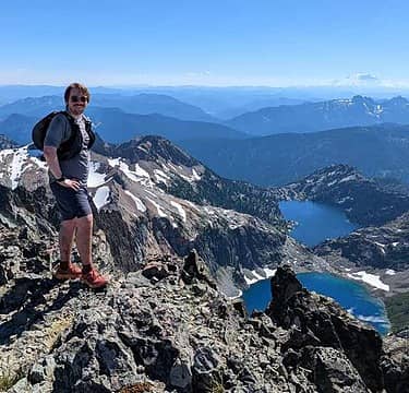
Point 5018 Ridge, County Line, Freedom Peak, Navaho Peak Traverse.
Did this line last Fall and thought it might be fun with Spring snow. It was. :-)
I came out via the Stafford Creek Trail, for the loop.
https://www.flickr.com/photos/44468754@N04/albums/72177720298910155
rubywrangler, RichP, JimK, puzzlr, zimmertr, jaysway, awilsondc
rubywrangler, RichP, JimK, puzzlr, zimmertr, jaysway, awilsondc |
| Back to top |
|
|
jaysway
Member
Joined: 16 Jul 2020
Posts: 347 | TRs | Pics
|
|
jaysway
Member
|
Fri May 13, 2022 1:31 pm |
|
|
The Teanaway look great covered in snow. Looks like a fun trip! I'm hoping to head that way in a month or so after there has been a bit more melting.
Now I Fly
Now I Fly |
| Back to top |
|
|
Waterman
Member
Joined: 21 Mar 2015
Posts: 590 | TRs | Pics
Location: Big Snow Quadrangle |
|
Waterman
Member
|
Thu May 19, 2022 4:55 pm |
|
|
Went north of Winthrop up cub creek to check out morels.
1 buyer in the area $8 lb. Lots of people roaming the area doing ok. Hasn't really got going yet, but plenty of room to hunt.
Two roads diverged in a wood, and I,I took the one less traveled by. And that has made all the difference.
Robert Frost
Slim
Two roads diverged in a wood, and I,I took the one less traveled by. And that has made all the difference.
Robert Frost
Slim
|
| Back to top |
|
|
Dick B
Member
Joined: 06 Jun 2013
Posts: 345 | TRs | Pics
Location: Redmond, Or |
|
Dick B
Member
|
Fri May 20, 2022 11:24 am |
|
|
I was in forestry school at the U of W in the late 50s. One quarter I got a job to help map the Arboretum. A previous crew had come in and grided the whole area into 100 foot squares. They set monuments at the corners of each square. We came in later with grid paper, a plane table, 100 foot rag tape, a 3 sided engineers scale and mapped everything within each square. It was really fun job, and my first exposure to what led to a surveying career.
mosey, hikerbiker, RichP
mosey, hikerbiker, RichP |
| Back to top |
|
|
zimmertr
TJ Zimmerman
Joined: 24 Jun 2018
Posts: 1224 | TRs | Pics
Location: Issaquah |
|
zimmertr
TJ Zimmerman
|
Thu May 26, 2022 10:21 pm |
|
|
Spent 2 hours schwacking in the rain with EternalBlue trying to find the CCC cabin today. Didn't find it but did find some enormous trees and lots of bear poop. Also heard a baby bear and almost stepped on a grouse nest. Both startled us quite a bit. Saw some huckleberries starting to bud. I understand the roof of the cabin is busted up now but I figured it might still be standing. Maybe not after the winter. If anyone knows the approximate coordinates please send me a PM so I can compare it to my track from today. I suspect we were very close.
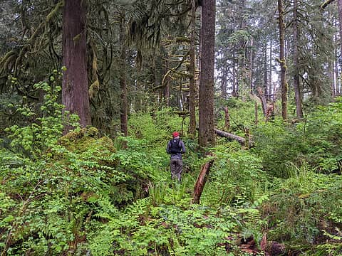 Super dense in some places 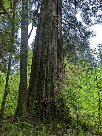 Some trees were 12+' in diameter. I've never seen any this large in King county before. 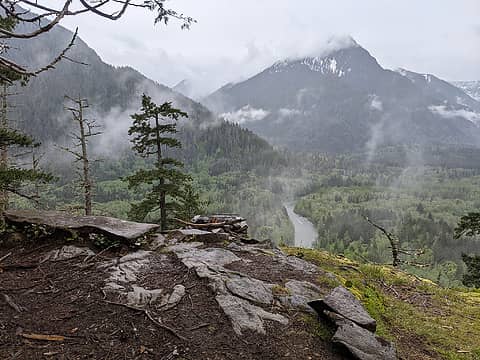 Pratt Balcony 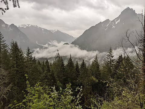 Somewhere up the CCC trail
|
| Back to top |
|
|
ngie
Member

Joined: 30 Dec 2019
Posts: 55 | TRs | Pics
|
|
ngie
Member
|
Fri May 27, 2022 6:54 am |
|
|
Was planning on heading up to somewhere in the Middlefork, but Cle Elum area looked better weather-wise. Wanted to head over to North Davis too, but way too many steep slopes with cornices, not having flotation, and a late start didnt seem like a good idea (plus we were both pretty tired).
Cleared some limbs and trees lower down, but there are tons more that need to be sawed/moved out.
We both got a tick each :/..
Cornices looked like a warm week or two away from dropping.
Snuffy, KascadeFlat, JimK, zimmertr, reststep, awilsondc
Snuffy, KascadeFlat, JimK, zimmertr, reststep, awilsondc |
| Back to top |
|
|
wyattmullen
Wyatt

Joined: 22 Oct 2021
Posts: 41 | TRs | Pics
Location: Skagit County |
Plenty of trip reports for this one in the last couple years so felt like I didn't need to post a full report. Snowshoed up and spent the night on Bacon this past Saturday (May 21). As noted in reports from last year, Bacon Creek Road is blocked by a couple hundred trees down about a mile from the Bacon Creek Bridge (or just over 4 miles from Highway 20). Most of them are step-over. Then after the bridge there's another big blowdown section with much larger trees. As amazing as it sounds I lost the road and spent an extra 20 minutes bushwhacking through the downed trees. So you now have to park 2 miles and 500' vertical below where you enter the forest.
Attempted to follow flagging in the Schwacky portion, but ended up staying too far to the right which lead to a couple class 3 moves on mossy ledges. On my descent I stayed in a dry stream gully which was much more pleasant. I tried to get an early start, but ended up waiting for 3 hours at point 4,800 for clouds to move in and snow to stabilize a bit more. Then I traveled as quickly as possible through what I'm calling the Amphitheater of a Thousand Avalanches.
Camped out about 20' from the summit in a small wind lip as nearby thunderheads caught the evening light and then uncountable stars appeared overhead. Woke up in the morning to dead calm with temps in the mid 20s. Tagged Canadian Bacon on the way down. 13 hours up (including 3 hours waiting for avalanche risk to drop), 5 hours down.
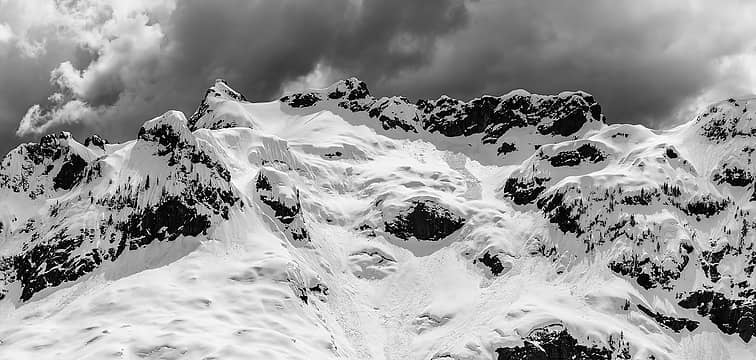 The Amphitheater of a thousand Avalanches was quite imposing 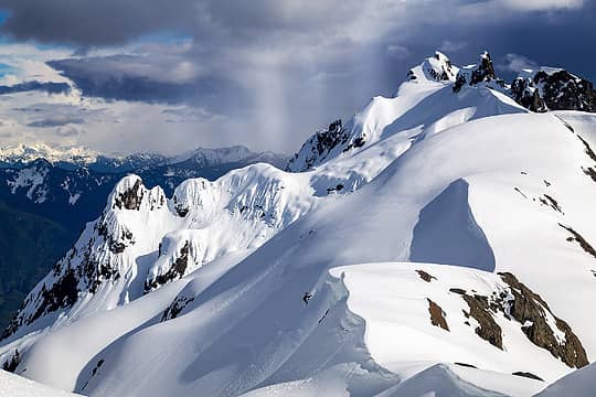 Stayed dry the whole day as thunderstorms danced nearby (Electric Butte) 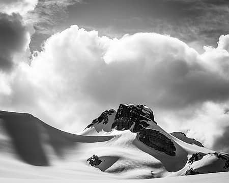 I was exhausted by the time I made it to the glacier, but the views kept me entertained. 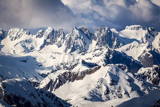 Such a good perspective of the Pickets 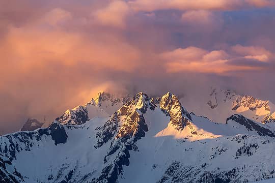 Golden light 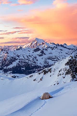 A decent campsite 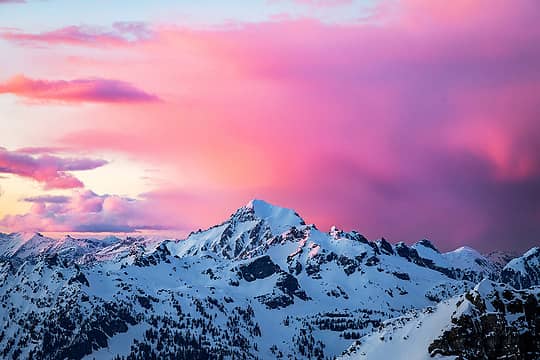 Blum Blushing 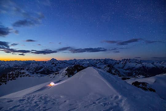 I was too tired to stay awake much later than 11 pm 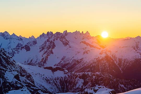 A rare sight the last few months
Snuffy, RossJames, Roly Poly, silence, Slim, Nancyann, Sculpin, zimmertr, mosey, Tom, RichP, Now I Fly, jaysway, half fast, JimK, reststep, Bramble_Scramble, Prosit, neek  fourteen410, zhenya, ALW Hiker, abkoch3, awilsondc fourteen410, zhenya, ALW Hiker, abkoch3, awilsondc  KascadeFlat, Kascadia KascadeFlat, Kascadia
Snuffy, RossJames, Roly Poly, silence, Slim, Nancyann, Sculpin, zimmertr, mosey, Tom, RichP, Now I Fly, jaysway, half fast, JimK, reststep, Bramble_Scramble, Prosit, neek fourteen410, zhenya, ALW Hiker, abkoch3, awilsondc KascadeFlat, Kascadia |
| Back to top |
|
|
KascadeFlat
Member
Joined: 06 Jul 2020
Posts: 316 | TRs | Pics
Location: Eating peanut M&Ms under my blue tarp |
Oh boy
impossible to follow up sunset shots from Bacon
Failed attempt on Persis this morning. We turned around around 4400ft when we got tired of sliding sideways into tree wells. 🤪 In a couple more weeks the snow will (hopefully) be melted up to the ridge line and make this more fun.
There was one other car and we followed those boot prints up. To that brave soul I tip my hat. Hope you made it and post a trip report!
For a good time call: 1-800-SLD-ALDR.
Nancyann, wyattmullen, reststep, mosey, RichP
For a good time call: 1-800-SLD-ALDR.
Nancyann, wyattmullen, reststep, mosey, RichP
|
| Back to top |
|
|
|
|
You cannot post new topics in this forum
You cannot reply to topics in this forum
You cannot edit your posts in this forum
You cannot delete your posts in this forum
You cannot vote in polls in this forum
|
Disclosure: As an Amazon Associate NWHikers.net earns from qualifying purchases when you use our link(s). |


