| Previous :: Next Topic |
| Author |
Message |
Matt
Tea, Earl Grey, Hot


Joined: 30 Jan 2007
Posts: 4307 | TRs | Pics
Location: Shoreline |
|
Matt
Tea, Earl Grey, Hot
|
 Sat Apr 05, 2014 2:23 pm |
|
|
Catching up on another trip report from last fall...
Dates: September 13-14, 2013
Destination: The Pleiades 7334 (407P): east western summit, west eastern summit & east eastern summit
Party: Dicey, Matt
Introduction: The Feller & The Goat Ledge
Summary:
We followed Stefan Feller's route.
Stefan's report was right, except for one detail he said that Beckey was wrong.
But Beckey now is right, except for one detail he got Stefan wrong.
Perhaps you'd like an explanation of that summary.
Here is Stefan's route description:
We went for Pleiades. Wouldnt you know Beckey guidebook has left out a lot of details and is incorrect? Here is how you do it.
Ascend a class 3 gully to the 7160+ col between the two western summits. Class 3 to get out of col to the eastern of the western summits. Go over the eastern of the western two summits (7280+). Descend an exposed and rotten class 3 gully on the eastern side of the western summit to the 6880+ colwe used a rope.
Ascend up from the col to a goat ledge.... It goes for about 200-300 meters around to the base of the 7160+ col between the eastern summits.... I now doubt Beckey did this peak. I was going by Beckeys description and it appears he says the farthest eastern pinnacle is the highest (7334). So that is what we did, and there is quite a cairn on the summit.
Beckey is wrong. The highest point is actually in the clump of spires at 7320+ on the map. You can access then highest point (7320+) peak from the east, but I do not recommend it as we did. In fact I recommend you ascend a potential class 3 way up once you pass the first gully while you are on the goat ledge.
I looked in Beckey's CAG3, 2nd edition, and he had an unhelpful description that mentions a lot of gullies but not how to get there. But CAG3, 3rd edition has a much more helpful route, because it's exactly Stefan's route. Except he got one detail wrong. The final line reads "Revision by Stefan Fuller."
So close, but missed it by one word. Hope that Feller guy won't mind
 the revised entry 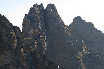 The Goat Ledge 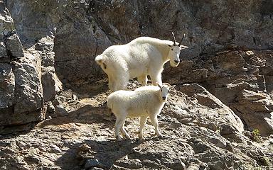 The Goats 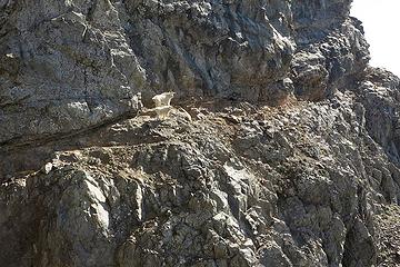 Goats on the The Goat Ledge 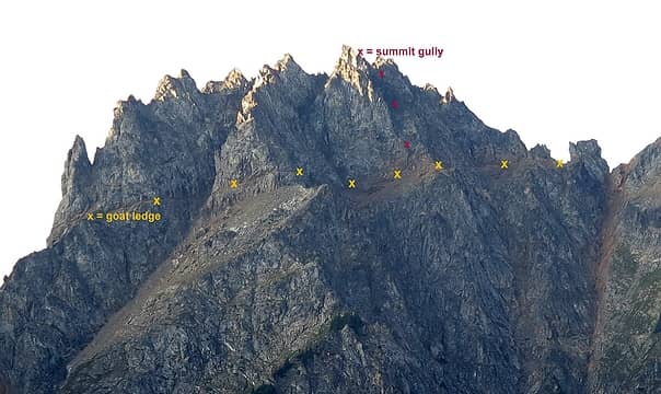 the goat ledge & summit gully 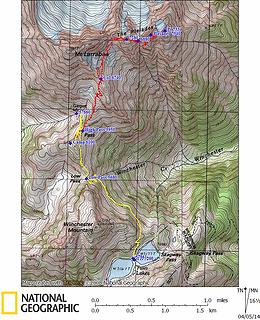 Pleiades GPS Track 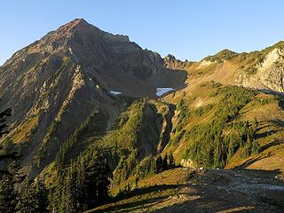 Evening above High Pass 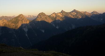 Evening light on Silesia Ridge 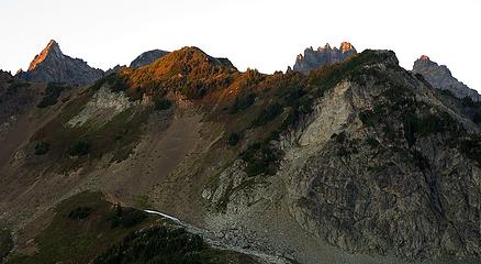 Sunset highlights the tips of The Pleiades 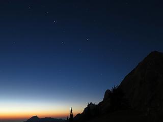 Big Dipper and deep clear light of evening, 8:29pm 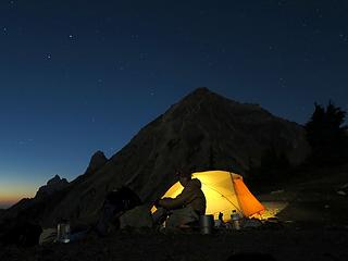 Sitting by the tent 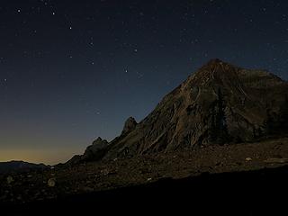 Stars over Larrabee, 9:51pm 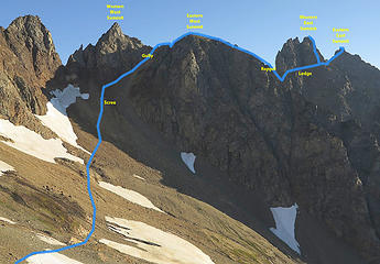 Route 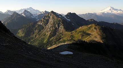 Morning Light on High Pass, Winchester & Neighbors 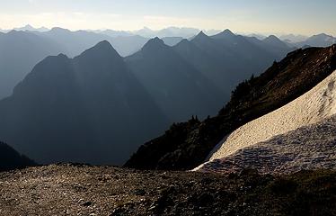 Morning Light on Silesia Ridge  Morning Snack 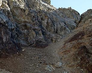 Goats on the scree below the gully 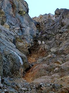 Goats going up the gully 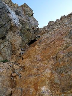 Unpleasant orange rock in the gully 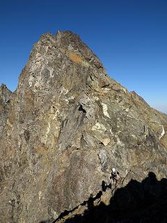 Dicey at the top of the gully... 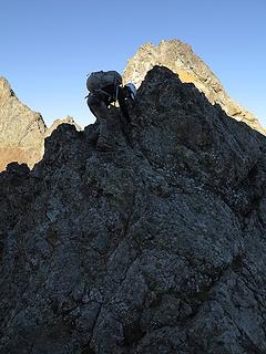 ... scrambling over a bump on the crest... 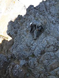 ...down into a minor notch... 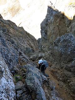 ... and back out of the minor notch. 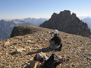 Dicey o the Eastern West summit 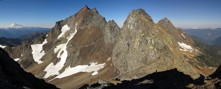 View back to Larrabee, Eastern East Pleiades, & American Border 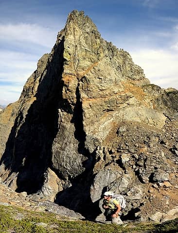 Carla above the rappel on the west side, with the rocky scramble up to the goat ledge on the far side. (You can see how the goat ledge is actually a fault that cuts all the way through the mountain, though it overhangs and is impassable on the north side.) 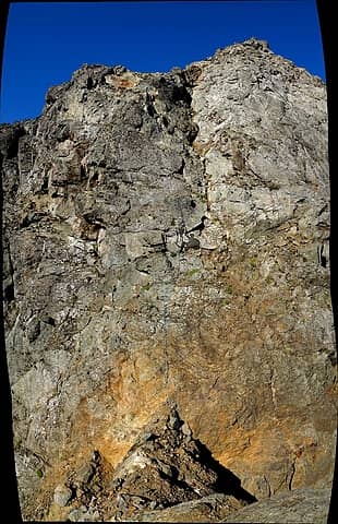 4 labels Looking back from the east side, with Dicey rapping into the notch (this is a larger stitched photo, so better viewed full size) 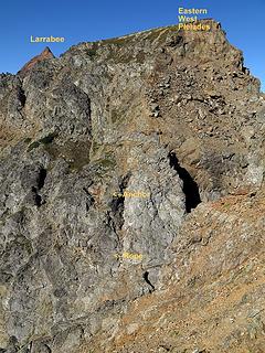 Looking back from a bit further up onto the east side 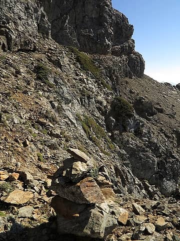 3 labels Cairn at the beginning of the goat ledge 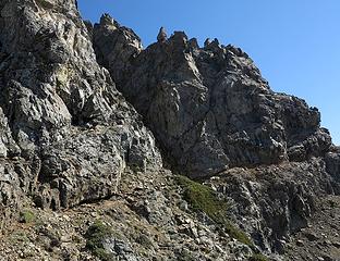 Goats out ahead on the ledge 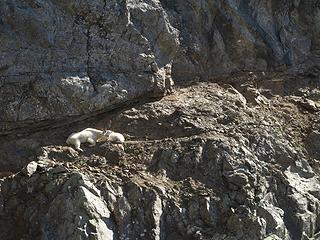 Just hanging out on their ledge 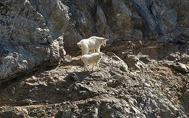 Goats leading the way 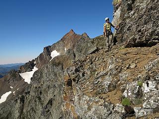 Dicey rounding a corner on the ledge 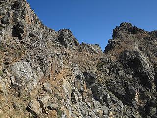 Goat ledge leading onward to final notch 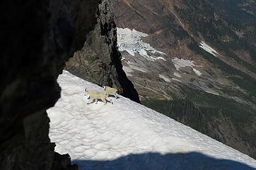 Goats continuing onto the snow 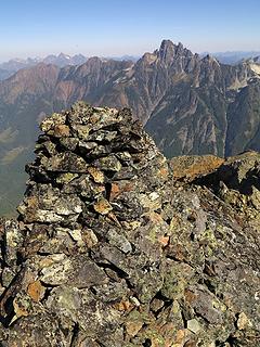 Summit cairn, with towers of Slesse behind 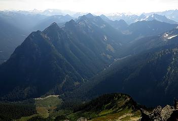 A view down the length of Silesia Ridge 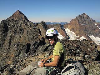 Dicey on the Eastern East summit 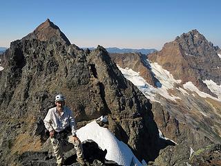 Me on Pleiades Eastern East summit 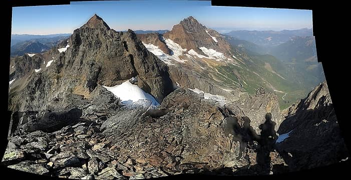 Grand View from the Eastern East summit. Note how you can see the goat ledge continue cutting around on the north side of this end of the peak as well. (Sorry about stitch errors in this panorama; maybe I can fix them later) 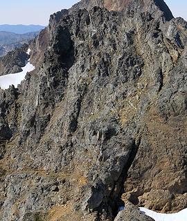 2 labels Goats heading up the Western East Summit 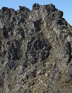 2 labels Goats higher below the Western East Summit 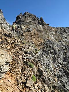 Carla on the goat path heading to Western East Summit with Eastern East Summit behind 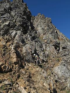 The gully we ascended is about 15 feet behind Dicey 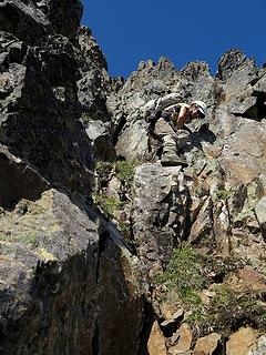 Dicey near the bottom of the first gully 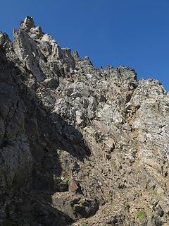 Dicey near the top of the second gully 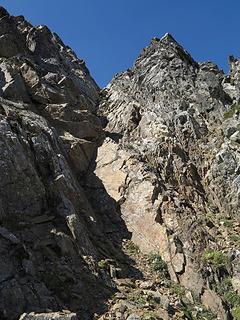 Dicey near the top of the V-shaped third gully (untrue summit on right, true summit is farther left) 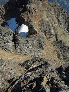 Finally looking down on the goats (the notch to the eastern east summit is by the snow at upper center) 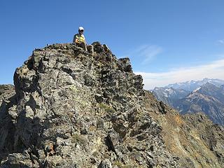 Dicey on the first spire we ascended 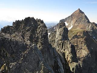 Dammit, that next spire is higher, but there's a slab-sided point in between 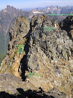 Carla coming up to the higher summit (we originally came up to the spire in the background, then had to climb down to the ramp on left to reach the notch) 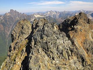 We're higher than any of these summits 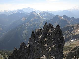 And higher than these spires 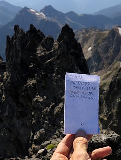 Register we made 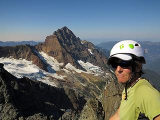 Dicey on summit (with American Border Peak) 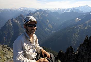 Matt on summit (with Silesia Ridge) 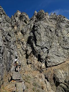 Heading back along the goat ledge (the gully we used is around the corner to the right) 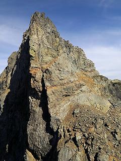 Looking back across the rappel notch to the goat ledge 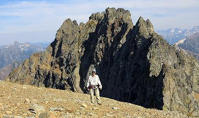 Back on the Eastern West Summit 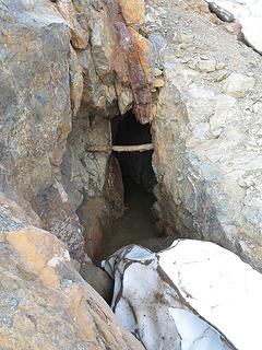 Mine adit at the end of the trail 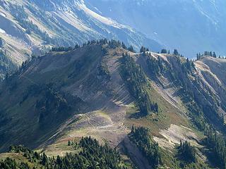 Heading back down to High Pass
As beacons mountains burned at evening. J.R.R. Tolkien
As beacons mountains burned at evening. J.R.R. Tolkien
|
| Back to top |
  
|
|
Yana
Hater

Joined: 04 Jun 2004
Posts: 4212 | TRs | Pics
Location: Out Hating |
|
Yana
Hater
|
Sat Apr 05, 2014 2:33 pm |
|
|
Wow, what a piece of junk.
The goats and the ledge must have been a pretty awesome experience, though!
PLAY SAFE! SKI ONLY IN CLOCKWISE DIRECTION! LET'S ALL HAVE FUN TOGETHER!
PLAY SAFE! SKI ONLY IN CLOCKWISE DIRECTION! LET'S ALL HAVE FUN TOGETHER!
|
| Back to top |
|
|
GeoTom
Member

Joined: 19 May 2005
Posts: 3215 | TRs | Pics
Location: Earth |
|
GeoTom
Member
|
Sat Apr 05, 2014 3:23 pm |
|
|
|
| Back to top |
|
|
dicey
custom title

Joined: 11 May 2004
Posts: 2870 | TRs | Pics
Location: giving cornices a wider berth |
|
dicey
custom title
|
Sat Apr 05, 2014 3:36 pm |
|
|
That was a fun trip!
My pics here:
Pleiades
|
| Back to top |
|
|
Gimpilator
infinity/21M

Joined: 12 Oct 2006
Posts: 1684 | TRs | Pics
Location: Edmonds, WA |
Thank you! The trip reports section has been sort of slow lately. I really appreciate seeing older trips like this posted. And what a trip! Very exciting stuff. 
|
| Back to top |
|
|
iron
Member

Joined: 10 Aug 2008
Posts: 6392 | TRs | Pics
Location: southeast kootenays |
|
iron
Member
|
Sat Apr 05, 2014 5:30 pm |
|
|
thanks for all the details and effort it took to put the photos and story together. i second yana's statement. that looks like crap. good views though in a beautiful spot, so that equalizes things i suppose.
|
| Back to top |
|
|
PeakJunkie
Member

Joined: 14 Feb 2009
Posts: 22 | TRs | Pics
|
|
| Back to top |
|
|
PeakJunkie
Member
Joined: 14 Feb 2009
Posts: 22 | TRs | Pics
|
|
| Back to top |
|
|
puzzlr
Mid Fork Rocks

Joined: 13 Feb 2007
Posts: 7220 | TRs | Pics
Location: Stuck in the middle |
|
puzzlr
Mid Fork Rocks
|
Sun Apr 06, 2014 1:47 pm |
|
|
Masterful TR as usual. Thanks for all the work you put in. Makes it fun to follow along on the trip. That area looks like it would be tough to navigate in bad weather.
|
| Back to top |
|
|
Magellan
Brutally Handsome

Joined: 26 Jul 2006
Posts: 13116 | TRs | Pics
Location: Inexorable descent |
|
Magellan
Brutally Handsome
|
Sun Apr 06, 2014 9:57 pm |
|
|
Really well put together report Matt. I imagine not many people make it here.
|
| Back to top |
|
|
Malachai Constante
Member
|
I have always been interested in the Pleadies after first seeing them from Haugean Pass. It is nice to see them up close and personal.
|
| Back to top |
|
|
|
|
You cannot post new topics in this forum
You cannot reply to topics in this forum
You cannot edit your posts in this forum
You cannot delete your posts in this forum
You cannot vote in polls in this forum
|
Disclosure: As an Amazon Associate NWHikers.net earns from qualifying purchases when you use our link(s). |


