| Previous :: Next Topic |
| Author |
Message |
mbravenboer
Member


Joined: 20 Oct 2013
Posts: 1422 | TRs | Pics
Location: Seattle |
From previous years, the Navaho Pass trail reports now and then feature great wildflower photos from May, but it looks like it's a bit too early this year to enjoy the show fully. There are lots and lots of glacier lillies, but the wildflowers that pace themselves a bit better are not yet out, except some at lower altitudes. Lupine hasn't made it yet beyond ~3000ft.
Spotty snow started at roughly 4200ft. The snow stays spotty for a long time, and does not become continuous until ~5500ft. The snow pack is pretty dense already, so we did not use our snowshoes. We also did not need traction. The trail is generally not very steep, and where it is steep, the snow is mostly gone.
We lost the trail a few times in the early partial snow cover. Water is running down the mountains everywhere, and because the forest is pretty open it is difficult to figure out where the trail exactly is. The various maps (USGS, Green Trails, OpenStreetmap) also show the trail in various places, and none of them seems very accurate. In any case, loosing the trail is no big deal here due to the easy terrain.
The cross of the east fork of the Stafford Creek at the end of the valley was a bit tricky, and resulted in a wet foot for me. On the road back we put a bit more avalanche debris in the creek.
One thing that confused me is that once you get to the pass, Stuart, Adam and Rainier are nowhere to be seen (as opposed to what the guidebook claims). You need to climb towards the Navaho Peak for about 400ft more before you get a good view of those.
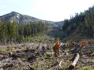 Avalanche Power 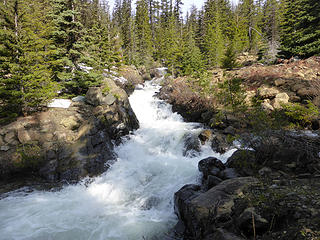 Stafford Creek split at the end of the valley floor 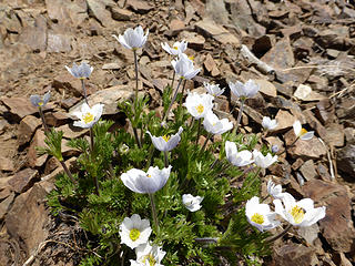 Anemone 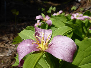 Trillium 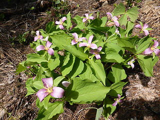 Trillium 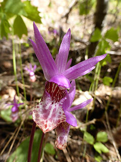 Fairyslipper (?) to Navaho Pass 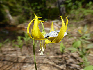 Glacier Lilly with a butterfly 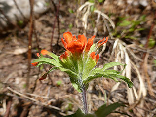 Paintbrush 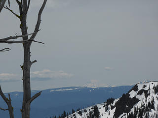 View of Mount Adams from Navaho Pass 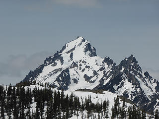 Mt Stuart from Navaho Pass 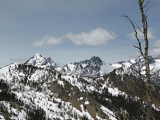 View from Navaho Pass from roughly ~6400ft: Mt Stuart, Sherpa Peak, Argonaut Peak 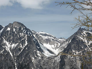 Little Annapurna 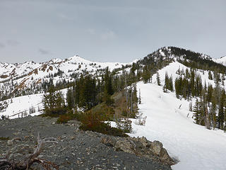 View of Navaho Pass 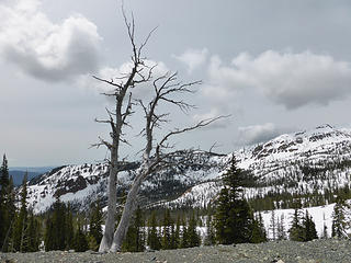 Navaho Pass tree 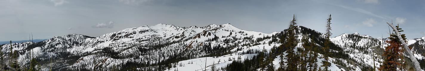 Earl Peak from Navaho Pass 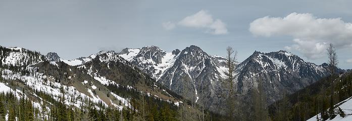 Panorama of the Enchantment Peaks
|
| Back to top |
  
|
|
olderthanIusedtobe
Member
Joined: 05 Sep 2011
Posts: 7708 | TRs | Pics
Location: Shoreline |
I was up there on Thursday. I also lost the trail several times and abandoned it all together as I neared the pass.
|
| Back to top |
|
|
tigermn
Member

Joined: 10 Jul 2007
Posts: 9242 | TRs | Pics
Location: There... |
|
tigermn
Member
|
 Sun May 25, 2014 5:36 pm |
|
|
Was anybody going up to the peak? Any tracks? Yea a bit early for the snow to be melted out for sure.
|
| Back to top |
|
|
mbravenboer
Member
Joined: 20 Oct 2013
Posts: 1422 | TRs | Pics
Location: Seattle |
@tigermn Yes, at the pass we ran into a couple that was going to the peak. It looked pretty doable: the snow was nicely consolidated higher up as well (like us, they did carry snowshoes).
On the road back we also ran into a group of four (after the Stafford Creek crossing). It looked like they were planning an overnight stay, so I guess they would also go to the peak.
There were now and then faint tracks ahead of us in the snow, but difficult to guess how old they were due to the quick ongoing melting (perhaps they were just from olderthanIusedtobe).
|
| Back to top |
|
|
olderthanIusedtobe
Member
Joined: 05 Sep 2011
Posts: 7708 | TRs | Pics
Location: Shoreline |
I would guess the snow cover is patchy between the pass and the peak. Looked to be quite a bit of bare ground. I climbed Miller Peak the next day after going to Navaho Pass and got a view back in that direction.
|
| Back to top |
|
|
tigermn
Member
Joined: 10 Jul 2007
Posts: 9242 | TRs | Pics
Location: There... |
|
tigermn
Member
|
Mon May 26, 2014 7:26 am |
|
|
| mbravenboer wrote: | | The cross of the east fork of the Stafford Creek at the end of the valley was a bit tricky, and resulted in a wet foot for me. On the road back we put a bit more avalanche debris in the creek. |
Where is this crossing you refer to? Is it the one right before that junction or later? I do recall Stafford Creek being deeper but that was the Stafford Creek just to the left of the fork (which isn't the way you go to Navaho. Of course I was always later in season so I'm sure it's different earlier. Just not sure which/where you are talking about.
|
| Back to top |
|
|
RichardJ
Member

Joined: 23 Oct 2012
Posts: 275 | TRs | Pics
Location: Maple Valley |
|
RichardJ
Member
|
Mon May 26, 2014 9:06 am |
|
|
My daughter and I did our first hike to Navaho the week before on the 17th and hammocked over the snow below the peak. I was amazed at the scattered patches of Yellow Bells on the way up. We will be back in June for at least two nights to really do it right. What a great early season hike.
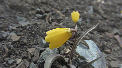 Yellow Bells on Navaho
|
| Back to top |
|
|
mbravenboer
Member
Joined: 20 Oct 2013
Posts: 1422 | TRs | Pics
Location: Seattle |
@RichardJ indeed, the Yellow Bells were wonderful!
@tigermn Here is the crossing that I was referring to. I don't expect people who regularly do early season hikes will have a problem with it though, so don't let it stop you  . And, there is enough material around to build more of a bridge if needed (an avalanche took down some trees in the area). . And, there is enough material around to build more of a bridge if needed (an avalanche took down some trees in the area).
|
| Back to top |
|
|
|
|


