| Previous :: Next Topic |
| Author |
Message |
1steppin
Member


Joined: 15 Mar 2014
Posts: 46 | TRs | Pics
Location: Seattle |
|
1steppin
Member
|
 Sun Jun 08, 2014 3:07 pm |
|
|
Hi everyone! Hope you all are enjoying the beautiful weather we have been having in the Great Northwest!
My Question:
I am planning a hike from Stevens Pass to Leavenworth in August and I am wondering about the unmaintained trail between Doelle Lakes and Frosty Pass. Ive read some reports that have said they've gotten lost on it and some saying they had no problems following it. Some are older reports and some newer. Wondering if there is anything we should look for or follow to stay on track. Is the trail easy to find from the Doughgod Creek trail? From the map, it looks like you cross the creek 3 times after Doelle before finding the unmaintained trail that forks off to the left. Any suggestions or advice is welcome please.
Thanks a lot and happy hiking!
|
| Back to top |
  
|
|
Backpacker Joe
Blind Hiker

Joined: 16 Dec 2001
Posts: 23956 | TRs | Pics
Location: Cle Elum |
Hey Step, I havent done that route, but Ive been thinking about it. If you Google Earth it you can mostly follow it from the lower lake (Doooley) to the pass.
Give that a shot.
"If destruction be our lot we must ourselves be its author and finisher. As a nation of freemen we must live through all time or die by suicide."
Abraham Lincoln
"If destruction be our lot we must ourselves be its author and finisher. As a nation of freemen we must live through all time or die by suicide."
Abraham Lincoln
|
| Back to top |
|
|
1steppin
Member
Joined: 15 Mar 2014
Posts: 46 | TRs | Pics
Location: Seattle |
|
1steppin
Member
|
Sun Jun 08, 2014 3:45 pm |
|
|
Thanks! I will check that out. it definitely looks, from the map, that you can follow the ridge line to Frosty, but you never know... Its a big world out there and theres a lot you can't see by looking at my green trails map. Not very many reports on this route either. Thanks again!
|
| Back to top |
|
|
Kim Brown
Member

Joined: 13 Jul 2009
Posts: 6899 | TRs | Pics
|
There's usually flagging tape at the entrance to the trail from the meadows. But that's not something to rely on if it happens to not be there. No other advice; it's been a long time since I was there. That's all I got for ya, sorry.
"..living on the east side of the Sierra world be ideal - except for harsher winters and the chance of apocalyptic fires burning the whole area."
Bosterson, NWHiker's marketing expert
"..living on the east side of the Sierra world be ideal - except for harsher winters and the chance of apocalyptic fires burning the whole area."
Bosterson, NWHiker's marketing expert
|
| Back to top |
|
|
1steppin
Member
Joined: 15 Mar 2014
Posts: 46 | TRs | Pics
Location: Seattle |
|
1steppin
Member
|
Sun Jun 08, 2014 3:53 pm |
|
|
Thanks Kim! No worries. Every bit of advice helps!
|
| Back to top |
|
|
HitTheTrail
Member

Joined: 30 Oct 2007
Posts: 5455 | TRs | Pics
Location: 509 |
I did it from Frosty to Chain lakes two years ago, you can read the TR here. From that direction there is only one place where the trail can be lost (in my opinion). That is just before the trail crosses over to the other side of the ridge. There is a large hunters camp/meadowy area where the tail has a vertical separation. Going in that direction you are on the higher side and can see where the trail continues on the other side. I think people coming from the other direction have trouble here by staying too low. Other than that I found it rather easy to follow. When you come into the meadow below Doelle Lake just head for the creek, cross it and continue on the trail. I think the trail going up Doughgod creek is long gone and would be a nightmare to follow.
|
| Back to top |
|
|
Tim Hagan
Member

Joined: 22 Jul 2008
Posts: 189 | TRs | Pics
Location: Bellevue, WA |
See my 2008 Trip Report for a map of my GPS track of the trail from Frosty Pass to Doelle Lakes (scroll down near the bottom).
|
| Back to top |
|
|
HitTheTrail
Member
Joined: 30 Oct 2007
Posts: 5455 | TRs | Pics
Location: 509 |
| Tim Hagan wrote: | 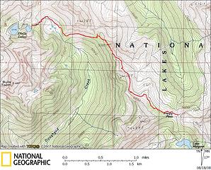 Frosty-Doelle Trail GPS Track |
The meadow where the trail has a vertical separation is just north of point 6122 on Tim Hagan's map. You can actually see the jog in the trail if you expand the map. You can also see the trail crossing the creek below Doelle lake.
|
| Back to top |
|
|
1steppin
Member
Joined: 15 Mar 2014
Posts: 46 | TRs | Pics
Location: Seattle |
|
1steppin
Member
|
Sun Jun 08, 2014 7:14 pm |
|
|
Thanks a lot you guys! Really appreciate the help!
|
| Back to top |
|
|
wolffie
Member

Joined: 14 Jul 2008
Posts: 2693 | TRs | Pics
Location: Seattle |
|
wolffie
Member
|
Sun Jun 08, 2014 8:36 pm |
|
|
See that little pass at 5525 where the track shows a blip to the north? An intriguing trail continues north from there -- maybe an old sheep hereders' trail.
I was in there 2007; pretty good shape then, neglected but easy to follow. 2007 loop trip You can do various loops from White Pine Creek TH if you come back via White Pine Creek -- it was mossy and neglected in 2007, but easy to follow. Clockwise, it commits you to fording White Pine Creek, so I wouldn't advice it until late season. Like, Wildhorse > Frosty >Doelle Lakes >Icicle Ck > White Pine Ck.
Some people have better things to do with their lives than walking the dog. Some don't.
Some people have better things to do with their lives than walking the dog. Some don't.
|
| Back to top |
|
|
snoholic
Member

Joined: 07 Sep 2012
Posts: 29 | TRs | Pics
|
|
snoholic
Member
|
Mon Jun 09, 2014 10:53 am |
|
|
Did that route a few years back. I do not remember any challenges finding the way out of Doelle to Frosty. Bring you fishing pole for Doelle  The only route finding issues we had was getting from Cabin Creek to Icicle ridge. (Trail was non-existent due to blow down). Basically had to bushwhack over blowdown all the way to the ridge. Maybe it is better now? The only route finding issues we had was getting from Cabin Creek to Icicle ridge. (Trail was non-existent due to blow down). Basically had to bushwhack over blowdown all the way to the ridge. Maybe it is better now?
|
| Back to top |
|
|
Conrad
Meadow bagger

Joined: 25 Aug 2006
Posts: 2298 | TRs | Pics
Location: Moscow, ID |
|
Conrad
Meadow bagger
|
Mon Jun 09, 2014 12:22 pm |
|
|
I did it in '08; here's my TR. We did lose the trail, also while heading SE like you're planning, in the meadow N of point 6122, and ended up spending the night there. More details in my TR. Still, it was an enjoyable segment and I'd do it again. I hope you check out that unmapped trail that wolffie mentions which drops N from that saddle midway; I imagine it might drop down to some nice meadows, and I'd like to hear a report.
|
| Back to top |
|
|
1steppin
Member
Joined: 15 Mar 2014
Posts: 46 | TRs | Pics
Location: Seattle |
|
1steppin
Member
|
Mon Jun 09, 2014 1:56 pm |
|
|
Thanks a lot everyone for all the info!! you've been a really big help! I will definitely have a detailed trail report and photos from the trip for you so be sure to look for it around August 15th. Would anyone happen to know if Frigid Mountain is accessible from trail 1570 without going down the chatter creek trail?
Thanks again everyone! I am really excited for this trip!
|
| Back to top |
|
|
1steppin
Member
Joined: 15 Mar 2014
Posts: 46 | TRs | Pics
Location: Seattle |
|
1steppin
Member
|
Mon Jun 09, 2014 2:15 pm |
|
|
| 1steppin wrote: | | Would anyone happen to know if Frigid Mountain is accessible from trail 1570 without going down the chatter creek trail? |
Frigid Mountain is the unofficial name of the peak 7377 just west of Ida Lake on the green trails map in case you're wondering. It doesn't actually say frigid mountain on the map.
|
| Back to top |
|
|
1steppin
Member
Joined: 15 Mar 2014
Posts: 46 | TRs | Pics
Location: Seattle |
|
1steppin
Member
|
Mon Jun 09, 2014 2:23 pm |
|
|
| Backpacker Joe wrote: | | If you Google Earth it you can mostly follow it from the lower lake (Doooley) to the pass. |
Holy moly Joe! I guess I don't use google earth enough. You can actually see the trail from Doelle follow the ridge line all the way to Frosty! Thanks a lot!
|
| Back to top |
|
|
|
|


