| Previous :: Next Topic |
| Author |
Message |
Ski
><((((°>


Joined: 28 May 2005
Posts: 12832 | TRs | Pics
Location: tacoma |
|
Ski
><((((°>
|
 Sun Aug 24, 2014 3:00 am |
|
|
Queets River Trail - 56th Anniversary - 08-10-14 - 08-13-14
USGS 12040500 556 CFS - 08-10-14 @ 05:30 PDT (31% below median average.)
Central Park 58° F @ 07:55 PDT
Amanda Park 71° F @ 09:10 PDT
Sunrise (Kalaloch) 06:07 PDT
Sunset (Kalaloch) 20:37 PDT
Eighteen (18) vehicles at trailhead at 10:25 am (plus my own). No Backcountry Permits in trailhead registration kiosk.
Ford at Sams almost knee deep.
Passed no less than thirteen (13) parties all doing a quick march out: one solo hiker, Scott, with whom I spoke briefly at Andrews Upper Field; one group of five; and the rest in twos and threes and fours.
Did I mention there were no Backcountry Permits in the trailhead registration kiosk? It is doubtful Olympic National Park has any idea about user loads on the Queets.
This bridge at 0.2 miles was just installed a year ago and was slightly repositioned during a high water event sometime during the last 12 months. This little ditch is only about three feet wide in midsummer.
A little over a mile and a half in is Andrews Lower Clearing - aka "Andrews Field" - still erroneously labeled as "Anderson Field" on the Custom Correct "Queets Valley" map.
This view is looking northwest from the southeast "corner" - not the view usually seen in most photos. The location of the Andrews Barn would have been just to the left of the small spruce in the center of the image.
There's a little footlog bridge over a mucky little drainage there at the eastern edge of Andrews Lower Clearing ("Andrews Field").
A little bit farther up the trail there's a plank bridge that's about 20 years old spanning a devilish little ditch full of salmonberry. If I recall correctly, this bridge was built by volunteer Don Gores to replace the old one that collapsed.
Just before Coal Creek is Andrews Upper Clearing, where I stopped and talked with Scott and two other hikers, one of whom knew me from the internet. I was unable to find any remnants of the old barb wire or fence posts along the southern edge of the remnant of the clearing, but that may have been because I was kind of distracted talking.
Andrews Upper Clearing, noted in the 1975 Sally S. Williams paper "A Survey of Abandoned Homestead Clearings in the Queets Valley" as having belonged to Vic Andrews, was originally a small clearing which has been encroached upon over the years by the forest and is now pretty much overgrown with Evergreen (Cut-Leaf) Blackberry (R. Laciniatus). The first view is looking towards the northeast. The second view is looking towards the northwest.
At Coal Creek a huge tree conveniently parked itself and has been utilized as a footlog bridge for the last decade or so.
A bit farther on, just before the trail breaks out onto a nice view of the river and Sams Ridge, there's sometimes a little log bridge set up over a muddy little drainage that might be an easy leap one day, and an easy faceplant the next.
Ran into party #14 at Spruce Bottom - two old boys who were looking for more action. I sat and we talked for a good while.
Finally got up to camp about half past four and set up the tent. Weather was very warm and sunny all day: temps in the mid-80s. The river was really low, but there was enough water for a few dives. A party of two came in a bit later and camped a little ways upstream.
Had dinner and tea just before the sun dropped about 8:25. It was still warm- about 70° F. Just a faint bit of color in the light hitting the top of the ridge at Harlow. At 9:00 was really starting to feel the combined effects of two hours of sleep followed by four hours of driving and six hours wandering up the trail. Managed to stay awake long enough to watch the Space Station fly over at 10:07 and went to bed.
Monday the sky broke clear at dawn. Got up about 7:00 and had oatmeal and tea for breakfast.
Walked downstream to take a few photos.
The remains of the structure at Smith Place have deteriorated just a little bit more during the last year. Only the view from the northeast corner has any resemblance to "structure".
Upper Crossing Way Trail
The Upper Crossing Way Trail is the first 3/4 mile of what remains of the long-abandoned Tshletshy Creek Trail.
One of the gentlemen I spoke with at Andrews Upper Field said they had been unable to find it and spent the afternoon brush-bashing their way back to Tshletshy.
From the northwest corner of the remains of the structure at Smith Place, bear due north 100 paces and find a moss-covered 4x4 post in the ground near an old mossy maple.
From that point the beginning of the trail is about a hundred feet east-northeast.
See it now?
The trail is difficult to follow at points. Keep your eye out for orange tags and cut logs. There are a few new small blowdowns along the first half mile since Pangratz last cleared it about six years ago.
My little sister and I used to play on the "magic bridge" when we were little kids. It's a huge old log spanning a marshy area. There's a step cut into the western end of it, and a snip of flag tape at its eastern end. It's turned into a fairly prolific nurse log, supporting hundreds of tiny hemlocks.
view of bridge looking northeast. see the tape?
view looking east. see the tape?
view from the bridge:
another view from the bridge:
view west from end of bridge. see the tape now?
The trail continues eastward, becomes lost in a new small spruce blowdown for about a hundred feet, and then can be picked up again for another hundred yards or so until it becomes lost in a tangle of jackstrawed spruce.
From there just bear east until you find the creek, which is only a couple hundred yards farther on.
I bumped the camera and must have hit one of the "settings" buttons, which made it start acting crazy. Having left my glasses at camp, I couldn't see the tiny labels on the buttons so I headed back down the creek and crossed just above the mouth of Tshletshy, where there's a nice site up on the bank above the river, now vacant, although it's a sketchy climb down to the river for water.
About 1:30 or 2:00 a solo helicopter buzzed by. First up the Queets, then down about a half mile above Tshletshy, then back down the river right overhead - could not possibly have been more than 300-400 feet above the river.
John Morrow raises a point that perhaps needs a little more attention.
Being the duly elected mayor obliges me to perform my annual janitorial duties, so I picked up (using the old time-tested "two old sticks chopsticks" method) enough toilet paper blossoms to fill a couple good-size shopping bags from an area about 50 feet wide by 200 feet long.
If the National Park Service and the National Forest Service made half as much effort to educate the public about disposal of human waste as they do about securing foodstuffs from bears, our public lands might be more pleasant places to visit.
Went down and dove into the river a few times, and then picked up a pile of sticks so I could have a little fire later. Managed to bash myself in the nose breaking a piece of driftwood in half, resulting in much blood shed and many oaths sworn.
Tied up a lure and went down and tossed it in a few times, but to no avail.
Looked up to see the site upstream now occupied by a couple people.
Had spaghetti for dinner. Still clear and warm - mid 70s - at 8:30. Clouds came and went all day, but still very warm.
Built a little fire down on the gravel bar.
The sky was clear enough to watch the space station fly over at 9:18 and 10:54, but at 12:29 the clouds were thick enough to obscure the view and I went to bed.
Tuesday, August 12, 2014 is supposed to be the peak of the Perseid Meteor Showers, but once again, just like the last three or four years, capricious weather fouls up the best-laid plans.
Woke up about 7:00 to what sounded like distant rumbling. I didn't really pay much attention to it and dozed off for a bit. About 8:30 it was getting louder so I got up and made a cup of tea and oatmeal in a hurry while the sky got darker and the thunder louder. Saw a good-sized flash just the other side of Kloochman. By 9:00 it started sprinkling, and by 9:15 it was really coming down. (My father would have said "Like a cow pissing on a flat rock.") I stood back under the alders to eat my oatmeal and then dove for cover into the tent.
I woke up about 2:00. The rain had stopped, the sun was trying to come out, and it was getting really warm. Big puffy clouds blew around the ridge tops to the east, but it was clear and sunny to the west, although it got a little hazy about 4:00.
Went for a little walk down the gravel bar and found a full bag of "Captain Crunch Snack Mix" that had been sliced open and abandoned. Nearby there were two bobbers floating in a shallow puddle near the river. Who the hell fishes the Queets with bobbers?
Unlike Oyster Lake, there is no shortage of tadpoles here.
Or the inexplicable.
And certainly not the awesome.
Had a cup of tea and enjoyed the warm afternoon. No neighbors. No noise today.
The sky got hazy about 6:00 and then later overcast with a fairly low, but light cloud cover.
Had dinner and watched the sun go down behind the ridge about 8:30.
Had a little fire down on the gravel bar and waited for the space station to fly over at 10:06, but the cloud cover was too thick to see either of its two passes this evening.
While stepping to the left a little too close to a log, I started to lose my balance and reacted by twisting over to the right, which caused what we later guessed is an Intercostal Muscle Strain. Whether it is or isn't, it still hurts like hell ten days later.
Ahh.... the joys of advanced age.
This sucks.
Went to bed about midnight after a few cups of tea and several ibuprofen.
The rain started drumming on the tent about 3:00 am. Listened to it for a while and went back to sleep. Got up about 7:00 and it was still raining. Crawled back into tent and slept until about 9:00. Got up and looked at the sky and the clouds down low on the ridges.
Packed up a wet tent and gear and headed out just after 10:00.
In less than a mile my feet were soaked from the wet brush wicking water down into my socks.
About a mile and a half down one of the shoulder straps on the pack broke, probably overloaded with the ten or fifteen pounds of water I was now hauling with my tent.
I nursed it down to Spruce Bottom where I could stop under one of those big trees and get out of the rain long enough to effect some kind of repair.
There was a party of three camped there, and while I figured out a way to do a patch job on the shoulder strap with my belt, I talked to the man who was camped there with two ladies.
We found that we had in common that on at least one or two occasions, we'd had days out in the wild where we had an urge to take off our pack and just toss the sonofabitch down over a bank and say to hell with it.
Of course, that would mean arriving back and the trailhead with no car keys or money, so I put the pack on and stomped down the trail, my belt buckle jabbing me in the back with every step.
Met a young couple coming in at Andrews Lower Field. They beamed they were headed up to Bob Creek in the rain.
Got down to Sams and forded without the usual shoe change, as the boots were soaked already. The water had come up just a little bit- it was about mid-thigh at about 2:00.
Four vehicles (plus my own) at the trailhead when I came out. Changed into almost-dry clothes at the campground and headed up toward Kalaloch.
Stopped in and said hello to Birdie and new Ranger Bethany.
Got a coffee and stopped at Ashenbrenner for a quick snack in the rain.
It was relatively dry for the long drive home.
Got back home and unpacked soaked gear, ate some more ibuprofen, and resolved to schedule Queets trips around good weather forecasts as opposed to celestial events. For that matter, I may decide that the Perseids simply do not exist, as I have been unable to see them myself for several years.
Hoping for a good weather window in two or three weeks.
-
* re: "Trail Conditions" report on the Olympic National Park website:
There is no issue with stock getting past that little ditch at the eastern corner of Andrews Lower Field. (see photo above)
The "quarter mile of trail underwater" is a short section below Andrews Lower Field where the trail literally follows the bed of an ephemeral stream, which can be thigh-deep during big rain events (see TR on "ProTrails" website - photo here), but never during mid-summer. (*fixed on ONP's website 09/10/14 bk)
* edited/ammended 09/10/14 bk
"I shall wear white flannel trousers, and walk upon the beach.
I have heard the mermaids singing, each to each."
"I shall wear white flannel trousers, and walk upon the beach.
I have heard the mermaids singing, each to each."
|
| Back to top |
  
|
|
Ski
><((((°>
Joined: 28 May 2005
Posts: 12832 | TRs | Pics
Location: tacoma |
|
Ski
><((((°>
|
Sun Aug 24, 2014 1:47 pm |
|
|
report above edited and ammended 082413 @ 13:45 PDT
the troublesome shoulder strap:
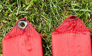 universal_field_equipment_trail_boss_shoulder_strap_04
"I shall wear white flannel trousers, and walk upon the beach.
I have heard the mermaids singing, each to each."
"I shall wear white flannel trousers, and walk upon the beach.
I have heard the mermaids singing, each to each."
|
| Back to top |
|
|
raising3hikers
Member

Joined: 21 Sep 2007
Posts: 2344 | TRs | Pics
Location: Edmonds, Wa |
wow, that's a lot of people on the queets trail. i really like that place, i need to make another visit. thanks for posting
|
| Back to top |
|
|
ranger rock
One of the boys
Joined: 14 Dec 2011
Posts: 2550 | TRs | Pics
|
Fun, report, thanks for posting it. I guess Queets is not the place to get away from it all. Maybe some people are getting their permits in P.A.? I never make the trip to P.A. to get a permit, but I know that some people do.
|
| Back to top |
|
|
Ski
><((((°>
Joined: 28 May 2005
Posts: 12832 | TRs | Pics
Location: tacoma |
|
Ski
><((((°>
|
Sun Aug 24, 2014 5:09 pm |
|
|
The couple I met in Andrews Lower Field on the way out said they picked up their permits at the South Shore Quinault Ranger Station.
I did not inquire of any of the others I met whether they had permits or if there were permits in the trailhead registration kiosk when they arrived.
In the past, when there were no permits in the trailhead registration kiosk and I asked those I met about permits, the majority of them told me they had not filled out a permit because there were no permits in the box when they arrived.
"I shall wear white flannel trousers, and walk upon the beach.
I have heard the mermaids singing, each to each."
"I shall wear white flannel trousers, and walk upon the beach.
I have heard the mermaids singing, each to each."
|
| Back to top |
|
|
sams rapids
Member
Joined: 26 Dec 2009
Posts: 112 | TRs | Pics
Location: near the Queets |
Another milestone for the mayor. 56 years. You must like going there. Sorry about the mess, it wasn't me. Thanks for the cleanup.
You missed me by 10 days. I also camped at Three Mistakes Camp. There were not any paper flowers when I was there. I saw 6 or 8 people going in on a Friday as I came out. I think I had been the only one overnight in the valley. Your kitchen appeared as though you had just been there.
|
| Back to top |
|
|
Ski
><((((°>
Joined: 28 May 2005
Posts: 12832 | TRs | Pics
Location: tacoma |
|
Ski
><((((°>
|
Mon Aug 25, 2014 9:49 pm |
|
|
Had to go to the Pioneer Reunion that weekend, or we'd have met up there.
From conversations I had with the groups coming out on the 10th there were apparently several parties camped there the week prior to my going in. Low water seems to bring out the crowds.
Hopefully we'll get some big water this season and it will all get a good washing.
Presently thinking about maybe the 7th, depending upon a good weather window.
"I shall wear white flannel trousers, and walk upon the beach.
I have heard the mermaids singing, each to each."
"I shall wear white flannel trousers, and walk upon the beach.
I have heard the mermaids singing, each to each."
|
| Back to top |
|
|
waflycaster
Member

Joined: 22 Jul 2011
Posts: 21 | TRs | Pics
|
Did a one night quick trip up the queets to camp at Spruce Bottom and then hiked about 2 miles past Tsheltshy Creek as a side trip during the second weekend in August.
There was 20 cars at the trailhead at 1am when we showed up the night before. Never in all my 15-20 trips to the area have I seen that many cars at the trailhead. Of the 20-30 people encountered during the 2 day trip I found that only 2-3 of the groups had acquired the required wilderness camping permit to spend the night.
Also found people fishing with bait, treble hooks, barbed hooks and keeping their catch to eat for dinner and bait containers/lures left on the river bank. (this river is catch and release only, single point barbless hooks, no bait, no trebles no barbs allowed) Also found the disposal of human waste to be horrendous, and garbage left at campsites. No ranger was on duty at the remote station and no back country rangers were encountered on the hike.
I was quite pissed off by all this and called the ONP Offices the next monday during normal business hours and could not get a live body to answer the phone, and left a voicemail. No body returned my phone call. 
|
| Back to top |
|
|
Ancient Ambler
Member

Joined: 15 May 2007
Posts: 1092 | TRs | Pics
Location: Bainbridge Island |
Very enjoyable TR and photos, Ski. It's always fun to see what's going on out there from your mayoral perspective. Sounds like a frustrating final day. Hope you've found some relief from your muscle strain.
|
| Back to top |
|
|
cascadetraverser
Member

Joined: 16 Sep 2007
Posts: 1407 | TRs | Pics
|
Very cool! 56 years of travel on the Queets! Cool TR...Bummer about the pack.
|
| Back to top |
|
|
|
|
You cannot post new topics in this forum
You cannot reply to topics in this forum
You cannot edit your posts in this forum
You cannot delete your posts in this forum
You cannot vote in polls in this forum
|
Disclosure: As an Amazon Associate NWHikers.net earns from qualifying purchases when you use our link(s). |


