| Previous :: Next Topic |
| Author |
Message |
ranger rock
One of the boys


Joined: 14 Dec 2011
Posts: 2550 | TRs | Pics
|
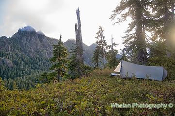 camp 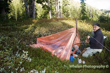 Phil's tube tent 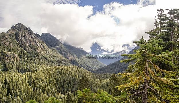 view into the heart of the wilderness 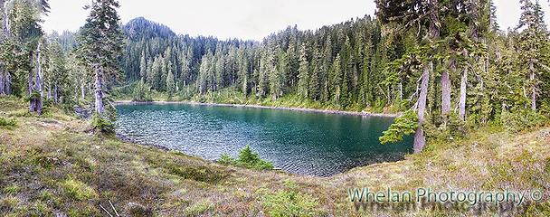 a sloppy pano 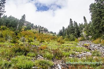 The steep meadow 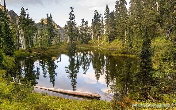 Wonder tarn we camped at 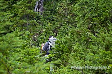 heading back into the woods 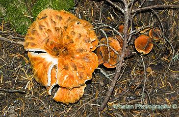 scaly chanterelles, don't eat them! 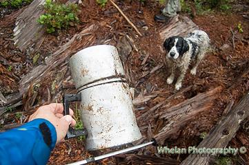 Deerguy's coffee perker? 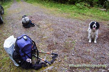 Patches before 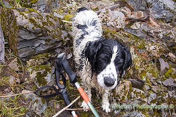 Patches after 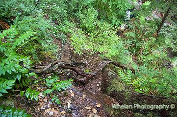 would you like to hike down this in the rain with a full pack on your back? 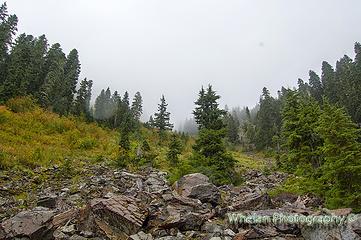 The meadow was wet and slick on the way back
|
| Back to top |
  
|
|
Chico
Member

Joined: 30 Nov 2012
Posts: 2500 | TRs | Pics
Location: Lacey |
|
Chico
Member
|
 Wed Sep 03, 2014 9:52 pm |
|
|
| Ranger Rock wrote: | | I tried to cut and past my entire report here but none of the line breaks were included. It's way too many line breaks for me to put in manually. Is there a way to cut and paste text into this form and have the line breaks show up? |
No problems with it here.
|
| Back to top |
|
|
ranger rock
One of the boys
Joined: 14 Dec 2011
Posts: 2550 | TRs | Pics
|
| Chico wrote: | | Ranger Rock wrote: | | I tried to cut and past my entire report here but none of the line breaks were included. It's way too many line breaks for me to put in manually. Is there a way to cut and paste text into this form and have the line breaks show up? |
No problems with it here. |
Well on my computer even my line breaks from my text are missing here where you quoted it.
|
| Back to top |
|
|
Chico
Member
Joined: 30 Nov 2012
Posts: 2500 | TRs | Pics
Location: Lacey |
|
Chico
Member
|
Wed Sep 03, 2014 10:03 pm |
|
|
Looks like it was a "true wilderness experience". Quite rare these days. Sounds like an interesting little corner to visit.
|
| Back to top |
|
|
Chico
Member
Joined: 30 Nov 2012
Posts: 2500 | TRs | Pics
Location: Lacey |
|
Chico
Member
|
Wed Sep 03, 2014 10:05 pm |
|
|
| Ranger Rock wrote: | | Well on my computer even my line breaks from my text are missing here where you quoted it. |
I removed all the breaks so it was a more efficient use of the page space.
|
| Back to top |
|
|
Magellan
Brutally Handsome

Joined: 26 Jul 2006
Posts: 13116 | TRs | Pics
Location: Inexorable descent |
|
Magellan
Brutally Handsome
|
Wed Sep 03, 2014 10:21 pm |
|
|
Unreadable here. (FF) Just fine on the blog. 
|
| Back to top |
|
|
Ski
><((((°>

Joined: 28 May 2005
Posts: 12831 | TRs | Pics
Location: tacoma |
|
Ski
><((((°>
|
Thu Sep 04, 2014 12:57 am |
|
|
| Chico wrote: | | a "true wilderness experience" |
an adventure for sure.
"I shall wear white flannel trousers, and walk upon the beach.
I have heard the mermaids singing, each to each."
"I shall wear white flannel trousers, and walk upon the beach.
I have heard the mermaids singing, each to each."
|
| Back to top |
|
|
ranger rock
One of the boys
Joined: 14 Dec 2011
Posts: 2550 | TRs | Pics
|
A few more pictures.. I'm pretty sure that there was a much better way to do this. Maybe Deerguy can set us straight when he gets home..
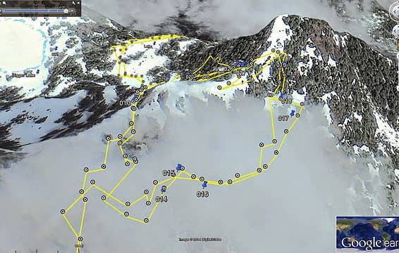 It was a steep route but there was no snow when we did it 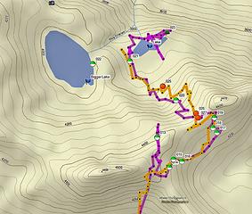 I have a feeling there was a better way to do this 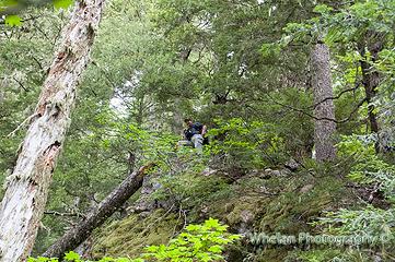 Phil takes the high road and nearly falls off of it. A tree saved him from death. I took the low road.
|
| Back to top |
|
|
Deereguy
Member

Joined: 22 Sep 2010
Posts: 65 | TRs | Pics
|
|
Deereguy
Member
|
Thu Sep 04, 2014 10:58 am |
|
|
Ranger, Congrats to the both of you. You made it in the first attempt.
Exploring that area for over 40 years, we ,never saw a girl. Actually, we've seen few people except some loggers many years ago that got helicoptered in. They left a mess.
Yes, you're right. There is a game trail down after you circle the hump to the left. It was pretty grown over in July.
Many berries on the way up the meadow? Seems like you may be getting, already have the off trail fever.
|
| Back to top |
|
|
ranger rock
One of the boys
Joined: 14 Dec 2011
Posts: 2550 | TRs | Pics
|
| Deereguy wrote: | | Ranger, Congrats to the both of you. You made it in the first attempt.
Exploring that area for over 40 years, we ,never saw a girl. Actually, we've seen few people except some loggers many years ago that got helicoptered in. They left a mess.
Yes, you're right. There is a game trail down after you circle the hump to the left. It was pretty grown over in July.
Many berries on the way up the meadow? Seems like you may be getting, already have the off trail fever. |
Thanks Deerguy. Have you ever seen a dog up there? There was evidence that someone had been there maybe a day or two before us. I found one candy wrapper and one footprint near the tarn. Maybe they belonged to the guy who lost his camera up there.
I've never seen any girls up there either, not even when I looked in the mirror.
I want to go back and find that easier trail. I have a feeling it comes out right at the campsite at the South end of the lake. It would be fun to go there just a few weeks into the fall and with my big camera.
The rain made the trip out hell. We sure could have used an extra day to rest up there before the hike out too, but Phil had to work the next day.
There were plenty of berries, the best tasting ones were up at the tarn. Patches got up in the morning and started picking and eating them on her own. She was really hungry.
I enjoy off trail travel, but I'm scared to do it alone. I don't trust my routefinding skills enough for that just yet.
BTW you have three unread PM's from me in your inbox here.
|
| Back to top |
|
|
reststep
Member
Joined: 17 Dec 2001
Posts: 4757 | TRs | Pics
|
|
reststep
Member
|
Thu Sep 04, 2014 1:16 pm |
|
|
Thanks for the report.
Are there some good camp spots at the larger lake?
"The mountains are calling and I must go." - John Muir
"The mountains are calling and I must go." - John Muir
|
| Back to top |
|
|
ranger rock
One of the boys
Joined: 14 Dec 2011
Posts: 2550 | TRs | Pics
|
Yes there were a couple of really good campspots. A high spot on the North end of the lake looked nice. I did not explore the low spot on the South end of the lake, I suspect that is where the way trail comes out to the lake.
|
| Back to top |
|
|
BackwoodsDrifter
Member
Joined: 07 May 2013
Posts: 12 | TRs | Pics
|
Epic hiking for me, if I went alone I might've given up before getting out of the Skoke valley! But having Patches kept me going, I couldn't give up when she was always in front. Coming back out was the other way around though, Patches kept under my feet a lot.
All my gear is car camping stuff, many thanks to the Mossy Mom for setting me straight! I was still short a packable tent for this hike and with no time to shop around so I spent $12 on a emergency tent. On the plus side, that tent weighs 14.75 ounces with it's string. But next time I think I'll be upgrading to a contractor-grade lawn & leaf bag...or better!
Got to go to work, but I'll throw some pics up here later tonight.
|
| Back to top |
|
|
BackwoodsDrifter
Member
Joined: 07 May 2013
Posts: 12 | TRs | Pics
|
I had just a week before this trip, hiked up the old road just because it was there. I had no idea I would be coming back to this road so soon! At the time, I didn't know about the way trail cutting across the hillside so I went right through the first switchback without seeing any sign of a trail there. At least I did pause to look at that switchback and considered how it looked like an overgrown landing that I could potentially explore. I did make it up all the way to the upper end of the road, and then saw a well established foot path continuing on up. I wanted to go up that, but it was late and I was only dayhiking that time.
So I was talking to Shauna about having made this minor little hike, when all of a sudden she's asking me to go on a real hike, into the area up above that I've been wondering about. And she's got all kinds of trip reports, routes, secret trails, lakes - everything all laid out and just waiting for someone to team up with & go. So of course I went for it! Cool secret trail, getting up & over a ridge I've been looking at for a while = fix the car some other time, I'm a goin' hikin'!
Once you know there's a trail at the switchback, that's all you need to know to find it. Just look for an easy way into the bushes, and your already doing it right. You will see a hiker shaped hole cut right through all the branches on the uphill side of the landing. The other thing you need to know is the GPS coordinate for where to turn and start going up. Between the trail start at the landing and the point to go up, the sidehill route going in just follows a constant slope upwards. There are several places on this sidehill section where you will lose sight of the trail. There's trees blown down across the trail, burying it. Some other places are just a bit overgrown, and a few spots that are just not dug in enough to leave much of a path to follow. I just decided whoever cut this trail was keeping it as simple as possible and took the straight & narrow line of travel. Every time I lost the path, I just looked forwards along the line of travel, and after another 10 or 15 feet I was always picking the pathway up again. I kept telling myself, so far this path just doesn't up & jump upslope or down, so just go forwards where it looked like the trail was going to go before you lost sight of it. There's lots of really old blazes along this section, as well as up above along this entire hike. So it's worth the time to always look at the trees every step of the way. Sometimes you just need to go up past a tree that's blocking your view forwards, to see the path again. Having a GPS track already laid out in advance, hand drawn at home was a nice touch. I could compare my progress to that track on my GPS in order to see how the path was crossing the slope at my position, that helped to keep picking the path up.
This is looking down the first creek:
Finally, a view out from inside this forest! This narrow slice of Skoke valley will soon be left behind.
I'm showing this pic to people and saying things like, "see how clearly obvious the trail is at this spot?" And they keep saying "what trail?"
The notches in the logs of course! What more do you need to know?
Big trees, trail like your just strolling around in a park:
Second Creek, looking down at - "Soooo, just where's that trail again?"
But you can see that the easiest thing to do is get to that rock wall, and from there, even if it's brush-busting, you will want to go up those logs. But take a few more steps and you will see a 'path' down into this mess!
She's standing right in the middle of the trail, cant you tell?
Once you're down there, you'll see a lot of steps cut into the logs. And a nail that's sticking up where you really don't want to go sliding! Slippery logs alert! I have a 3 liter that started with an even 2 at the Jeep, I decided to refill here back to 2 liters. The water jumps off the rock wall in a nice little streamer that dumps neatly into the bladder. Very nifty!
No pics of the really big blow down. But there's a place where you will really need to push around in the bushes for a ways, just try to stay on the same elevation as where the path fades, go a few feet higher from that and forwards!
After making the waypoint to go upslope, and after some rocky stuff I finally get my breath back enough to bother with pulling the camera out:
Rest break, looking back down at the trail:
And then I see my GPS tracklog is acting funny. It's not following my route, the onscreen track is just a line coming from the second creek straight to my current position. I've been setting waypoints after making the turn uphill, so I can see where I was. I decided to turn of the stupid track logging and just start setting lots of waypoints from here on out. I think I was only getting two satellites, but I can't remember where in all those darn menus is hidden the ability to show the satellite page. Ignore it & continue.
Another rest break, looking back down. Trail is easy to spot here:
The bees nest is just a little further up from here.
There's a section where the trail cuts to the left through open forest, jumping from one ridgeline to another. That bees nest is right where you turn & cut hard left at about 30 degress upslope. Lots of alternate routes 20 feet below that nest!
And then the hogsback. I really wanted to go right up that, but I couldn't see where the trail was and I knew that rocky knife might turn into too much adventure. But I just had to go up there to look at it. At this point, you have just made the leftwards ridgeline, the path has climbed up onto a saddle and appears to drop off the other side into nothing. There's a nice little knoll downslope in the trees to take a break on. I learned later that the trail is dropping sharply down the backside of this saddle, but at this point you just can't see it. There's a few saplings growing across it.
So I decide I need some adventure, I just haven't been having any near death experiences yet! So if you like almost dying, do like me and go right straight up that rock knife, veer to the left to see what things are like way down below a cliff. You'll likely spot the trail like I did. I could see it from above, while standing on the tip of a outcrop. And then I see there's a way to go down right there, to rejoin the trail. Between that outcrop and the cliff is a narrow gap of death. If it wasn't for a big tree in that gap to use for a slide check, I probably would've turned back like a smart fellow and made my way back to where I ought to have been. But nope, just got to do this. It's a guy thing or something right? Moment my foot touches dirt and I let go of the rocks, I'm sliding down that gap. I hit the tree hard enough to make some noise, so I say 'I meant to do that!' out loud but really what I meant to say can't be said here. There's a 3 inch goat path of tippyness to get down out of that gap by, or could just choose suicide and slide down the slope 30 feet before there's anything to grab. I'm not brave enough to choose suicide yet, so I try to keep my balance & tippy-toe the hell out of that spot.
Ok, so now my heads straight. I'm back on trail and I'm trying to avoid any further bonus points because suddenly a boring hike sounds like a fun thing! This pic is skirting the hogsback on it's lefthand side:
And that too.
So, after the 'go left of the hogsback' section you finally get out of the trees and into the bottom of the 'Big Meadow'
Looking downhill:
Along the trail, you need to cross a small grassy area, get on the other side of the boulders, then you're ready to go up:
And up means 'up there':
Like, all the way up there to the skyline, up there!
Before leaving the treeline, I tied a yellow ribbon. This is looking back at the trail:
Contemplating how all these car sized rocks came to rest at the bottom of a steep slope:
Yay! No more route finding! Just go up this and finally just enjoy the day, right?
Ok, that trail is over there somewhere. I have a waypoint on it, got ribbon on it and now I'm photographing it so I can get this layout in my head. I also decided to tie another ribbon where I can see the one at the treeline.
Uhh, say these rocks are like, about ready to continue rolling downwards. All they need for action is an unwary boot!
Still looking around down here while getting left behind:
As you climb, you get pummeled by these little critters:
Rest break, just trying not to start sliding & die is all...
A little higher up, another rest break:
Finally, at the top! Looking at Rule Creek with Capitol Peak hiding in the clouds to the right:
And looking east from the top:
Looking east, out at the Four Stream basin:
Done resting at the top of the meadow, now we're heading towards that saddle we're supposed to drop down from:
On the way across the top is a well established game trail:
Game trail seems to end at this patch of blueberries:
In hindsight, I can tell that this was looking out above the steep area to the right hand side from where the game trail drops down.
At the bottom of the blueberry patch, looking back up and just not 'getting it'
Ok, we really lost the trail at this point. In hindsight, I see my big mistake is in not keeping my main compass where I can grab it on a moments notice. I tucked it into a rear pouch on my pack for an emergency backup. I didn't feel like taking the pack off to get the compass, I was a bit tired & not thinking it out clearly. I didn't have my GPS oriented on north like I would do with a paper map, so I didn't know that the easy looking route on-screen wasn't actually where I was looking downslope.
Here's my position & the direction I was looking:
This is the clearest view through the trees, but it's looking right over the steepest portion of the other side!
Deerguy said it, just above on this thread. We should've cut left through the bushes and continued forwards. The yellow dotted line is what I wanted to do, the black cone is what I was looking at. My lack of compass led me to assume that I was looking at the dotted route, and I could see that what I was looking at was way too steep, so I decided the map was wrong and that we needed to find another route.
This wont be the last time my lack of compass leads me astray....
If you decide the easy route is just not your thing and it's really just not taking long enough to get to the lakes, then follow along here because we have a nice route for you to follow! First, go back up the game trail. Then go back to the top of the meadow. Now look at that Four Stream basin. Pretty isn't it? We both agreed that if we don't find the route down to the Five Stream lake, we'll just lame out on some Four Stream stuff instead. We saw a mud puddle down below in the Four Stream basin, so we know where water is at the moment. But I'm trying to forget about that mud puddle! I got yellow flags marking the bushier parts of this. You'll drop down the Four Stream side in a small clearing and go sidehill to the left, staying out of the bushes for the moment. Go as far as possible in the clear, with your mind set on reaching that northern saddle. Eventually, no choice but to bushwhack down & northwards. Eventually you'll drop onto a shelf that brings you out under the saddle in a nice open meadow. No easy way up, so go past the saddle to the edge of the clearing under it. Now go up the treeline, skirting the righthand side of the clearing. You'll find some old blazes just inside the trees, so that proves we weren't the first to go this way. At the top, go forwards along the ridgeline to reach the saddle. It looks like it makes sense at this point, and there's been blazes spotted, so we're not worried about that dead end at the first saddle.
Dropping down, always angling to the left, I managed to finally spot our goal:
It's also at this point that I clearly hear two people talking to each other down at that lake. I told Shauna but she didn't hear it. She yells out anyways, and it seems like those voices suddenly quit. I think there's someone down there trying not to be noticed! Or maybe it's bears that just happen to sound like people talking? But other than a candybar wrapper that doesn't really look all that fresh, we never ran into anyone or bears either. Oh well, just call me crazy. I'm hearing voices 'out there' in the wilderness and we're getting more & more committed to dropping down this slope with no sign of a trail. So of course I completely lose track of where that lake is and just assume we're heading to it.
Finally, break out of the trees at the top of another one of those steep slippery rocky meadows:
Lake must be at the bottom of this, I don't need that GPS now!
There's some little pond, must be some extra little bit of water right next to the lake. I still don't need that GPS anymore, we just need to get down there and stroll right past that little bit of water. Piece of cake!
Looking back up where we broke through. I don't think this needs any ribbons marking it. It looks pretty obvious to me:
No Patches! Stay out of the water!
We don't need a soaking wet dog for the rest of the night!
So, lets move on and get to the lake, right? Or maybe we'll just stand at the edge of a seriously steep drop off and look out across a whole lot of Five Stream basin wondering just where in the heck did that upper lake go? I'm still too tired to bother with that stupid compass, and besides, I already know that lake is just 'over there', must be on the other side of a ravine? Don't know why there's a ravine right there in my way, some sort of creek or something. But that lake must be further away than I thought!
It's getting late, one hour to go before it becomes nice to have already gotten our tents pitched. And we both are ready to bust another half mile down this slope! But it's really too steep over there, so we circle around like lost sheep and I still refuse to use that stupid compass. Finally, we both admit it, we gotta look for the lake in the morning. It's just about sunset and we both have our packs on. I got a feeling I might need to give up and maybe compromise a little. Ok, back to a marginally flatish area and throw the packs down. Shauna picks some bushy spot, apparently because she likes that coil spring mattress she left behind at home. I'm going for this bear trail with no bushy in the way, because I like having bears lick my face in the middle of the night while they try to get to their watering hole.
Next morning:
You call that a tent? Nope, I don't either!
But isn't this why I'm here?
Looks like a wet dog alright:
Funny things you only see in the morning, like this:
I can skip breakfast after feasting my eyes on this:
But after a night of a constant migraine & waking up all night, then spending the early hours with chills & sweating at the same time. I'm not really hungry. I had a hernia surgery not too long ago, maybe two months, and I'm thinking maybe I overdid things a bit. But after some coffee, and then some tea, and then a coffee mocha hit, I'm starting to feel a little better and maybe eat something.
And now that all my stuff is spread out on the ground I can finally casually unfold this paper map, break out the compass and try zoning out on some mappy time. Compass tells me to rotate the map, ok. Map tells me I'm an idiot, ok. Ah crap! That lake was right behind us!
Gear up, hike 100 yards. Drop our packs and look up the side of that ravine, up a clear open slope that looks like a lot of animals been travelling here. Uhm, that ravine is the outlet stream isn't it? From that lake? Ok, upslope!
Here I am:
Finally!
And several really nice campsites, all around the shoreline here. Too bad we didn't use one of those! But at least we get to stroll around in this:
And all around the lake are views like this:
So, been there. Done that. Do I want to go back? Of course I do! I think there's a route north from the upper lake, skirting clockwise around the Five Stream basin that can reach down to the other lakes up north. I'd like to test that theory out, but maybe Deerguy or somebody could say something about this?
Anyways, going back out did not go faster like expected. It started to sprinkle heavily, not really raining. But enough that the Big Meadow became a death slide that needed very careful footwork to get down. I stayed focused on falling down smoothly, even once made a stumble turn into a graceful leg stretch. Yeah, I meant to do that! The yellow ribbon at the bottom of the Big Meadow was really much appreciated. My boots were soaked & getting loose, feet getting sore spots. Delayed re-tying my boots a little too long. I still have a blister on the bottom of my foot to show for it. Everything seemed to take longer than when we came in. The sidehill section was twice as long going back out! Everytime we stopped to negotiate a log or other trailness, Patches started to dig a hole to sleep in and call it a day. I started to worry if I was going to have to make a stretcher & drag Patches out. I slowed down a tiny bit and just tried not to stop too long anywhere.
Crossing the streams was more treacherous than on the way in, due in part to that rain. The banks on the streams are a bit steep & loose. Precise care is needed, so I'm glad I had plenty of power bars!
We started to see signs of more casual hikers who turned back. At the trailhead were a set of burnouts from another car. Jeep was a-ok, still had all it's glass intact and started right up on the first try. So get that heater cranked up and call it a day!
|
| Back to top |
|
|
ranger rock
One of the boys
Joined: 14 Dec 2011
Posts: 2550 | TRs | Pics
|
Great trip report Phil, funny too! I wondered if you were getting blisters in those giant boots. It's nice to have a hiking partner who does not whine and who knows how to use a compass.
What about it Deerguy, where exactly is that animal trail that we missed? Maybe you better guide us up there next time. Phil wants to see the lake with the island in the middle of it.
|
| Back to top |
|
|
|
|
You cannot post new topics in this forum
You cannot reply to topics in this forum
You cannot edit your posts in this forum
You cannot delete your posts in this forum
You cannot vote in polls in this forum
|
Disclosure: As an Amazon Associate NWHikers.net earns from qualifying purchases when you use our link(s). |


