| Previous :: Next Topic |
| Author |
Message |
DIYSteve
seeking hygge


Joined: 06 Mar 2007
Posts: 12655 | TRs | Pics
Location: here now |
|
DIYSteve
seeking hygge
|
 Mon Sep 22, 2014 8:09 am |
|
|
The route of which jetlag speaks sounds like the route Randy and I descended on a ski tour in July 2012, although perhaps we swung farther N. Randy had done it late season, reporting that much of it was treaded (miner? hunter?).
Lowell's pic of the cliffs accurately conveys a feeling of skiing on PSL next to those big cliffs. Here is a different perspective via a longer lens:
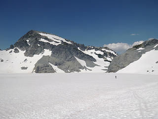 There go the waxless bases
|
| Back to top |
  
|
|
Jetlag
Member

Joined: 17 Aug 2010
Posts: 1410 | TRs | Pics
|
|
Jetlag
Member
|
Mon Sep 22, 2014 8:55 am |
|
|
BigSteve, yes, there are sections of good tread on what looks like it is going to be a cliffy brush section on the rim of the Daniel glacier basin. Also some sections of tread around a nice camp on the Eastern rim just below that area with a good water source.
Not many good sections of tread on this route just above the PCT, but the terrain is easy.
Neat picture of the 2012 ski tour across the lake. We ran into a Tacoma Mountaineers group led by Dayhike Mike just a couple weeks after that and, boy, the crossing of Pea Soup sure looked dicey!
|
| Back to top |
|
|
marydave
Musical Hikers
Joined: 11 Aug 2010
Posts: 182 | TRs | Pics
Location: Seattle |
|
marydave
Musical Hikers
|
Mon Sep 22, 2014 9:07 am |
|
|
That's a great illustration of glacial retreat in our neck of the woods.
Thanks, for posting that here, Lowell; I've enjoyed reading your articles on alpenglow.org for years.
That area is definitely on my list of future places to visit, also inspired by earlier trip reports to Jade Lake and Dip Top Gap (I've been to Deception Pass a couple of times, but always en route elsewhere).
|
| Back to top |
|
|
GaliWalker
Have camera will use

Joined: 10 Dec 2007
Posts: 4930 | TRs | Pics
Location: Pittsburgh |
|
GaliWalker
Have camera will use
|
Mon Sep 22, 2014 9:08 am |
|
|
| Jetlag wrote: | | Not many good sections of tread on this route just above the PCT, but the terrain is easy. |
Once you break out of the trees. I'm not "hardcore" like you guys so it took me a bit of effort getting past the cliffs, lower down, and through the trees, but once I'd attained the meadow at ~4500ft, directly east of Pea Soup lake, it got a lot easier. I too was able to pick up the occasional boot tread on the ridge.
Lowell_Skoog, the historical photos are great, especially the final one. Thanks!
|
| Back to top |
|
|
Ski
><((((°>

Joined: 28 May 2005
Posts: 12832 | TRs | Pics
Location: tacoma |
|
Ski
><((((°>
|
Mon Sep 22, 2014 12:44 pm |
|
|
fascinating.
I have to wonder if I am the only one who noticed the notes on the 1941 photos were written with a fountain pen using the standard "office blue" ink?
the ballpoint pen didn't come to be commonly used until over a decade later.
"I shall wear white flannel trousers, and walk upon the beach.
I have heard the mermaids singing, each to each."
"I shall wear white flannel trousers, and walk upon the beach.
I have heard the mermaids singing, each to each."
|
| Back to top |
|
|
Jetlag
Member
Joined: 17 Aug 2010
Posts: 1410 | TRs | Pics
|
|
Jetlag
Member
|
Mon Sep 22, 2014 1:23 pm |
|
|
GailWalker, it was great to go back and see your wonderful TR and photos of Pea Soup Lake, completed before I knew about this site. Congratulations on attaining your objective.
As for the tree section of the route being brushy, the lower forest from Hyas Lake up to the PCT is devoid of any real brush. You must be referring to the short bit of forest above the PCT just to the right of Daniel Ford. If you start climbing further along the PCT toward Deception Pass, this can be avoided. There IS one short section of thick brush below the lower cliff bands on the left side of the creek above the PCT, which I now remember (we found a camera there) and I think this can be also be avoided by staying high up right of the creek. Other than that - great route!
|
| Back to top |
|
|
Lowell_Skoog
Member
Joined: 29 Oct 2005
Posts: 145 | TRs | Pics
Location: Seattle, WA |
|
| Back to top |
|
|
MtnGoat
Member

Joined: 17 Dec 2001
Posts: 11992 | TRs | Pics
Location: Lyle, WA |
|
MtnGoat
Member
|
Tue Sep 23, 2014 9:41 am |
|
|
Nice thread and comparison photos. I love the old, analog days notes with annotations written on photos. Flowersniffer and I did a route from Deception pass over Lynch peak and down into the basin in about 1991, and the ice was barely touching the lake at that time. All I had for reference then was of course much older pics, and we were bummed to find we'd missed the iceberg days (by at least a decade?)
Diplomacy is the art of saying 'Nice doggie' until you can find a rock. - Will Rogers
Diplomacy is the art of saying 'Nice doggie' until you can find a rock. - Will Rogers
|
| Back to top |
|
|
Jetlag
Member
Joined: 17 Aug 2010
Posts: 1410 | TRs | Pics
|
|
Jetlag
Member
|
Tue Sep 23, 2014 10:25 am |
|
|
Thanks for giving the link to your collection, Lowell. Watson was certainly active in 1941-42, hitting the highlights of the Alpine Lakes with a vengeance!
"Since the Cascade Range was considered too large to scout in its entirety" - Classic! The entire North Cascades north of Stevens Pass had to be disregarded!
Also, good to read about Ome Daiber's rescue activity. I missed several chances to hear him speak.
My father found his experiences in the Colorado Rockies to be quite useful when descending at night from a high mountain perch into Innsbruck.
|
| Back to top |
|
|
Larry
Member

Joined: 22 Feb 2003
Posts: 1084 | TRs | Pics
Location: Kitsap |
|
Larry
Member
|
Tue Sep 23, 2014 4:19 pm |
|
|
I am always blown away (and sad) that so MUCH ice has melted in the past decade or so. These images bring home the reality. When I was a pre-teen, the glaciers in the Olympic Mountains were also much larger than now. Sometime, if I can find them, I'll post before and after pics.
One of the neatest glaciers was on the east side of Diamond Mountain, with a lot of calving going on (about 1956) and the waves would surf across the lake and make a heck of a splash on the shore. I have a fragment in my mind of sleeping at the lake and hearing these 'booming' sounds during the night.
There was also a pretty active glacier flowing down from Mount Claywood.
|
| Back to top |
|
|
reststep
Member
Joined: 17 Dec 2001
Posts: 4757 | TRs | Pics
|
|
reststep
Member
|
Tue Sep 23, 2014 4:31 pm |
|
|
Larry, did you go up Hidden Creek?
"The mountains are calling and I must go." - John Muir
"The mountains are calling and I must go." - John Muir
|
| Back to top |
|
|
peltoms
Member

Joined: 13 Jul 2006
Posts: 1760 | TRs | Pics
Location: Worcester MA |
|
peltoms
Member
|
Thu Sep 25, 2014 6:07 am |
|
|
Bill Prater took a number of pictures of the glacier in the interval as Pea Soup began to expand.
|
| Back to top |
|
|
|
|


