| Previous :: Next Topic |
| Author |
Message |
MangyMarmot
Member


Joined: 06 Apr 2012
Posts: 474 | TRs | Pics
|
After several weeks of not being able to get to the mountains, I just had to get out this weekend. I was originally just planning on Tinkham, but as I drove to the trailhead, another plan took shape. Instead of parking at he twin lakes trailhead, I drove up road 9030 all the way to where it crosses the PCT. There was nobody else there yet.
I followed the PCT South to Mirror Lake. This section is quite flat so it went by fast. The weather was good, but the top of Tinkham would not shed a small cloud.
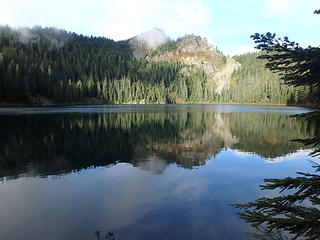 Tinkham and Mirror Lake 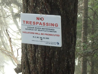 Big Brother is watching you! These signs were on every other tree. I must have passes at least 100 on Tinkham. 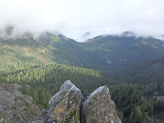 Looking back toward the car at the pass between Silver and Catherine. Both mountains are in the clouds. 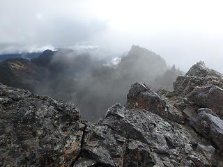 Looking East from the West peak of Tinkham 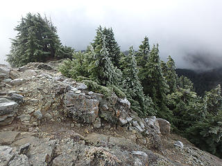 Frosty trees at the summit 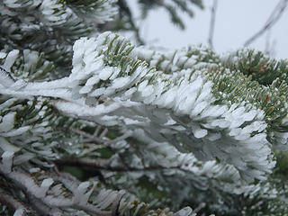 Frosted tree on Silver 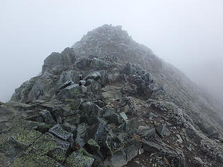 Ascending into the cloud. 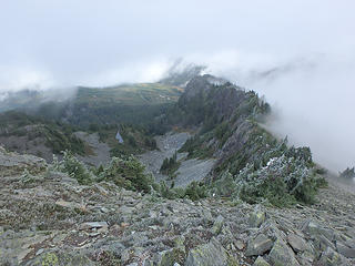 Looking North-East. The car is at the end of the ridge on the right.
|
| Back to top |
  
|
|
RichP
Member

Joined: 13 Jul 2006
Posts: 5634 | TRs | Pics
Location: here |
|
RichP
Member
|
 Mon Nov 03, 2014 11:36 pm |
|
|
I love that trail from Mirror lake to Tinkham. It's a good, short hike for newbies to a nice summit.
|
| Back to top |
|
|
MangyMarmot
Member
Joined: 06 Apr 2012
Posts: 474 | TRs | Pics
|
Yeah, I bet you get some nice views when it's not cloudy.
|
| Back to top |
|
|
joker
seeker

Joined: 12 Aug 2006
Posts: 7953 | TRs | Pics
Location: state of confusion |
|
joker
seeker
|
Tue Nov 04, 2014 11:57 pm |
|
|
Nice. Was there trail from the lake to the ridge? I recall coming down (reverse of your route up Tinkham) back in probably the late '90s and I don't recall much in the way of trail on that stretch. May have been a trail-ish up on the ridge crest itself. I do recall the signs dotted like fenceposts!
My favorite views from up there are when the clouds are shrouding the clearcuts to west and south, and there is clear sky to the east and some views to the north. That whole ridge can be a dividing line between moist and dry air.
|
| Back to top |
|
|
MangyMarmot
Member
Joined: 06 Apr 2012
Posts: 474 | TRs | Pics
|
Yes, there was a climber's trail that started at the campsites on the small ridge just South of Mirror Lake. It mostly followed the watershed signs. I lost it above the trees in a rock slope not far from the summit. There is another one on the West side going down toward Silver Peak. There were a lot of names in the summit register. It's a popular peak these days. It's in the new Goldman scrambling book.
|
| Back to top |
|
|
|
|
You cannot post new topics in this forum
You cannot reply to topics in this forum
You cannot edit your posts in this forum
You cannot delete your posts in this forum
You cannot vote in polls in this forum
|
Disclosure: As an Amazon Associate NWHikers.net earns from qualifying purchases when you use our link(s). |


