| Previous :: Next Topic |
| Author |
Message |
ranger rock
One of the boys


Joined: 14 Dec 2011
Posts: 2550 | TRs | Pics
|
The goal today was to start at the south end of the Dry Creek Trail and
hike up and over the saddle and down to the ridge top campsite. The
road to the dry creek trail is in good condition, meaning no trees or
rocks in the road but there are huge water bars that require a high
clearance vehicle to overcome.
Our hike started at ten am. I forgot how long the road section of this
trail is. Dry Creek trail used to go from The South Fork Skokomish
River to the staircase ranger station on the North Fork Skokomish. The
Shady land nature trail is actually a severed section of the Dry Creek
Trail.
I found a lot of Tetraplodon mniodes moss up there and it was in full
bloom.
ON the way back we wandered up Lebar Creek where there are clear
signs of an old but well maintained trail near the creek. I wonder if
this is the old Dry Creek Trail, maybe this is where the trail went before
it was routed up a logging road? We had our lunch on Lebar
creek.
Our hiked ended at about 6pm
Pictures later
|
| Back to top |
  
|
|
HumpnoocheeGirl
Member

Joined: 03 Feb 2011
Posts: 335 | TRs | Pics
Location: Grays Harbor |
Cool! Did you get pics of the new "old trail"?
|
| Back to top |
|
|
HumpnoocheeGirl
Member
Joined: 03 Feb 2011
Posts: 335 | TRs | Pics
Location: Grays Harbor |
| Ranger Rock wrote: | | The goal today was to start at the south end of the Dry Creek Trail and
hike up and over the saddle and down to the ridge top campsite. |
did you mean to say, the NORTH end of Dry Creek?
|
| Back to top |
|
|
HumpnoocheeGirl
Member
Joined: 03 Feb 2011
Posts: 335 | TRs | Pics
Location: Grays Harbor |
|
| Back to top |
|
|
ranger rock
One of the boys
Joined: 14 Dec 2011
Posts: 2550 | TRs | Pics
|
|
| Back to top |
|
|
ranger rock
One of the boys
Joined: 14 Dec 2011
Posts: 2550 | TRs | Pics
|
Old trail markers on the ridge
Old trail on Lebar creek Under the brush is a nice wide flat
trail.
Old cut log on old Lebar Creek trail
Our wanderings
|
| Back to top |
|
|
RodF
Member

Joined: 01 Sep 2007
Posts: 2593 | TRs | Pics
Location: Sequim WA |
|
RodF
Member
|
 Thu Jun 12, 2014 12:05 pm |
|
|
| Ranger Rock wrote: | | ON the way back we wandered up Lebar Creek where there are clear signs of an old but well maintained trail near the creek. I wonder if this is the old Dry Creek Trail, maybe this is where the trail went before it was routed up a logging road? |
Two trails on Lebar Creek are depicted on the 1955 Metsker map of T23N R5W.
In sections 19 and 30 are the Dry Creek Trail and LeBar Shelter on the upper branches of LeBar Creek, before the logging roads were built in the 1960s. (Note at the edge of the map, it appears a branch of the trail may have continued up Mount Tebo.) Dry Creek Trail originally joined the lower South Fork Skokomish Trail at Camp Comfort Shelter. Guessing you might've found this old section of the Dry Creek Trail?
In section 34 is a trail just east of lower LeBar Creek climbing north towards Prospect Ridge. The origin of this trail is shown on Metsker T22N R5W map in section 4 as just upriver of Intermount GS/Brown Creek CG. This trail is not depicted on the USGS Mount Tebo sectional or any USFS map I've seen, so it may have just been a way trail, maybe built by hunters to pack game or to some unknown mining prospect.
"of all the paths you take in life, make sure a few of them are dirt" - John Muir
"the wild is not the opposite of cultivated. It is the opposite of the captivated - Vandana Shiva
"of all the paths you take in life, make sure a few of them are dirt" - John Muir
"the wild is not the opposite of cultivated. It is the opposite of the captivated - Vandana Shiva
|
| Back to top |
|
|
HumpnoocheeGirl
Member
Joined: 03 Feb 2011
Posts: 335 | TRs | Pics
Location: Grays Harbor |
RodF, you are a walking/talking history machine! Love it! 
|
| Back to top |
|
|
ranger rock
One of the boys
Joined: 14 Dec 2011
Posts: 2550 | TRs | Pics
|
You can see on this
Where we wandered up LeBar Creek a bit and found the trail.. guessing it's the old dry creek trail or a spur campground trail..
If it's the actual dry creek trail it would be nice to know where it crossed Lebar Creek, I'd rather follow that than a logging road. Even though the road was built not much was logged past Lebar Creek where it crosses my track log.
Dry creek started at Camp Comfort and went all the way to Staircase, the Shady Land Nature trail is a severed section of the dry creek trail.
It looks like the trail went straight down the creek, but the road does not.. That area was logged though, so there would be no way to find the trail there.. Looks like the Shelter may have been in a logged area too.. although there is an old shelter up there at the 5 way intersetion.. it's fallen down, but it's a more modern one too.
Thanks Rod..
Current trail head
Older upper trail head left over from before they decommissioned the road to the trail head without converting it to trail.
There is talk of doing a proper road to trail conversion up there, it would be nice if it followed the old trail.
|
| Back to top |
|
|
RodF
Member
Joined: 01 Sep 2007
Posts: 2593 | TRs | Pics
Location: Sequim WA |
|
RodF
Member
|
Thu Jun 12, 2014 6:51 pm |
|
|
Here's a portion of the 1953 USGS Mount Tebo from the USGS Historic Topographic Map site, showing the entire Dry Creek Trail. I put a "?" at where I'm guessing you found the trail, if I read your track right? If so, you were above Dry Creek Trail, perhaps on an un-mapped spur trail that might've gone up towards Mount Tebo?
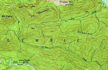 Dry Creek Trail, 1953 USFS Mount Tebo | Ranger Rock wrote: | | although there is an old shelter up there at the 5 way intersetion.. it's fallen down, but it's a more modern one too. |
I don't know where 5-way intersection is; might that be Steel Creek Shelter?
"of all the paths you take in life, make sure a few of them are dirt" - John Muir
"the wild is not the opposite of cultivated. It is the opposite of the captivated - Vandana Shiva
"of all the paths you take in life, make sure a few of them are dirt" - John Muir
"the wild is not the opposite of cultivated. It is the opposite of the captivated - Vandana Shiva
|
| Back to top |
|
|
Pyrites
Member

Joined: 16 Sep 2014
Posts: 1884 | TRs | Pics
Location: South Sound |
|
Pyrites
Member
|
Thu Jan 15, 2015 12:22 am |
|
|
I think the historical Dry Creek trail network is still up in the air. Use as a base for discussion the 1953 USGS topo provided by RodF.
http://tinyurl.com/DCUSGS1953
All the maps showing the trail are consistent from Staircase to crossing at ~1543' as shown on this map continuing up to the Dry/Le Bar divide. (Let's talk about stub to Dry Mountain later.)
The USGS then shows trail going past a large Le Bar trib, between Dry M. and hill 3949', the SSW downhill hill to Le Bar Creek, and then southerly crossing a saddle on Le Bar S. Fk. Skok divide, and connecting to the S. Fk. Skok trail upstream of Camp Comfort.
I think this is the current route, with the lower portion having remnant portions from logging and road building.
Next map is Metskers 1955 Mason County index map:
http://tinyurl.com/DCMET1955Index
When you zoom in you can see that, in addition to trail as shown on USGS map, there is a trail that drops down west side of trib to Le Bar Creek, follows trib to confluence with Le Bar Creek, crosses and turns largely westerly, crossing Le Bar S. Fk. Skok divide, and connection to the S. Fk. Skok trail downstream of Camp Comfort.
To add confusion the 1947 Metksers shows this trail, and not the trail to main basin of Le Bar as shown on the USGS:
http://tinyurl.com/DCMET1947index
I looked at an older copy of Metskers in Shelton, annotated by someone with pencil as 1941. It shows the a map consistent with the 1955, except that I believe connection to S. Fk. Skok trail is slightly farther downstream. Because of minor differences in larger scale township maps this document shows a clearer map than the 1955 series.
The direct route from the S Fk Skok to Prospect Ridge is a third trail.
RangerRock, I think you could have crossed the both the lower end of the existing and exterminated trail as shown on the USGS and the top intersection with the trail down the trib to further east. I'm eager to hear which it was.
Looking over the Metskers maps to the north and the west in the Park and the Forest I does not seem to show many stubs that were not accepted as trails at the time. Exception is Mount Lincoln way appears to continue to summit. Trails seem to be real.
Keep Calm and Carry On?
Heck No.
Stay Excited and Get Outside!
Keep Calm and Carry On?
Heck No.
Stay Excited and Get Outside!
|
| Back to top |
|
|
ranger rock
One of the boys
Joined: 14 Dec 2011
Posts: 2550 | TRs | Pics
|
Thanks for reviving this topic, I'm too groggy to get my head around your maps right now, but here is what my Delorme map showed me the other day. Look at the white line, looks like another route for the Dry Creek trail.
One thing for sure on all the old maps this that The Dry Creek Trail never took the route of the road that is now considered to be part of the trail. That road just cut off the trail, it never was the trail. The trail never switched back like that road does. I'm talking about the road where you now park to start your hike.
There was talk of converting that road to trail. I think it would be much better if they re-opened a route through the woods up Lebar Creek. Who wants to walk down an ugly old logging road?
I saw some old trail blazes on the top of Prospect ridge.
|
| Back to top |
|
|
|
|


 Lol....okay, looks like from the West end. Which would actually be the south end of the trail.....okay, I get it now.


