| Previous :: Next Topic |
| Author |
Message |
Backpacker Joe
Blind Hiker


Joined: 16 Dec 2001
Posts: 23956 | TRs | Pics
Location: Cle Elum |
I thought the road was paved beyond that point already. I guess not. Nice update.
"If destruction be our lot we must ourselves be its author and finisher. As a nation of freemen we must live through all time or die by suicide."
Abraham Lincoln
"If destruction be our lot we must ourselves be its author and finisher. As a nation of freemen we must live through all time or die by suicide."
Abraham Lincoln
|
| Back to top |
  
|
|
CascadeRambler
CascadeRambler

Joined: 05 Feb 2010
Posts: 20 | TRs | Pics
Location: CascadeRambler |
Thanks for sharing the pictures along with the update.
The Middle Fork road will likely remain closed for a week or more while repairs are designed and implemented. Today a large crack was found in the road bed in the area near MP 8.8 where the hillside has begun slumping, this may delay reopening the road even longer.
In the meantime if you want to get up to Mailbox Peak you will need to park along the SE Middle Fork road outside the roadblock at the road closed sign, just be sure not to block driveways or USPS mailboxes that way the residents won't mind.
- Ramblin the Cascade Range
- Ramblin the Cascade Range
|
| Back to top |
|
|
Dave Workman
Member

Joined: 06 Aug 2006
Posts: 3699 | TRs | Pics
Location: In the woods, by the big tree |
| iron wrote: | | thanks for the update MFK historian.
seems like a poor design if the culvert already failed. grr... |
Is it possible you are new around here?
The Middle Fork is notorious for this sort of thing. I've seen it happen before in a deluge like this. The tributary creeks literally erupt with water coming down off the ridges, and the Pratt and Taylor simply roar.
Combine that with the massive force of water coming down out of the Middle Fork into a rather narrow canyon in places,and it's the perfect terrain for flash flood conditions.
I'm not certain that anybody could design a foolproof road up there. And these so-called 100 year floods seem to be getting more frequent.
The images are impressive, but I know that spot.
"The essential American soul is hard, isolate, stoic, and a killer. It has never yet melted." - D.H. Lawrence
"The essential American soul is hard, isolate, stoic, and a killer. It has never yet melted." - D.H. Lawrence
|
| Back to top |
|
|
puzzlr
Mid Fork Rocks

Joined: 13 Feb 2007
Posts: 7220 | TRs | Pics
Location: Stuck in the middle |
|
puzzlr
Mid Fork Rocks
|
 Wed Jan 07, 2015 1:53 am |
|
|
| Dave Workman wrote: | | I've seen it happen before in a deluge like this. |
I feel lucky to have gotten in on the tail end of one of these events, but my goal is still to be there when the debris is actually moving boulders around (from a safe distance, of course)
I've been in contact with the party that was visiting Goldmyer that got stranded (comfortably) for a night. This video was taken by them at ~1:45pm on Monday just as the rain was tailing off so probably near peak creek flow. I didn't get there until almost 3pm and the water was much lower. Some earlier shots from 9am show mostly water over the road with no boulders, so a lot of the movement happened between 9am and 2pm.
And for comparison, this is what the same spot looked like after the 2009 flood which was even bigger. Photo is by Bruce Stirling.
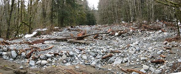 MP 9.9 creek after 2009 flood 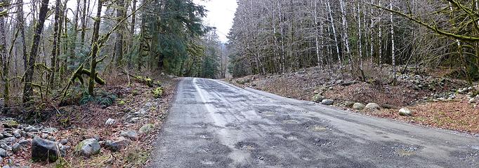 Same place in January, 2014
|
| Back to top |
|
|
Bernardo
Member

Joined: 08 Feb 2010
Posts: 2174 | TRs | Pics
Location: out and about in the world |
|
Bernardo
Member
|
Wed Jan 07, 2015 8:38 pm |
|
|
Looking forward to an update and more pictures.
|
| Back to top |
|
|
trailchick
Member

Joined: 06 Jan 2015
Posts: 6 | TRs | Pics
|
Hi there, I was part of the party that got stranded up near Dingford Creek while trying to return from Goldmyer the evening of January 4th. We encountered a washout about 3 miles from the Dingford Trailhead and were able to drive safely through it, but 500 feet later we hit another that was much too swift and deep to attempt at night. We had plenty of food and supplies and decided the safest option was to car camp and wait it out. The morning of the 5th we were surprised the washout was running much lower so we proceeded through only to be stopped by the large washout on MP 9.9 of the Middle Fork around 8:30am.
Sometime around 10:00am the volume and current of the washout exploded and it was running strong until around 1:30pm when it finally receded. It left so much debris that we still couldn't safely cross by car.
We were prepared to spend one more night and hike out in the morning when we ran into some guys from the ACI construction team checking out conditions. We also had the good fortune of meeting puzzlr, who was up there documenting the storm. With their help we forded back across the washout and got a lift back to Valley Camp. The ACI construction team confirmed that the bridge was undermined and likely dangerous to drive over, so I'm still waiting to retrieve my Jeep from the other side.
I can definitely say this was a memorable first time visit to Goldmyer! What an experience to witness this firsthand. Quite amazing the power of Mother Nature  I have quite a few pictures up here:
https://plus.google.com/photos/101103468185880220624/albums/6101805597909430593
And the whole crazy story up on my blog:
http://www.trailchick.com/2015/01/06/goldmyer-hot-springs-and-forces-of-nature/
Thanks to the ACI team and to puzzlr for giving us a lift out. It was a real pleasure meeting all of them!
I have quite a few pictures up here:
https://plus.google.com/photos/101103468185880220624/albums/6101805597909430593
And the whole crazy story up on my blog:
http://www.trailchick.com/2015/01/06/goldmyer-hot-springs-and-forces-of-nature/
Thanks to the ACI team and to puzzlr for giving us a lift out. It was a real pleasure meeting all of them!
|
| Back to top |
|
|
nordique
Member

Joined: 04 May 2008
Posts: 1086 | TRs | Pics
|
|
nordique
Member
|
Fri Jan 09, 2015 5:10 pm |
|
|
Three of my friends did Mailbox Peak yesterday and said the walk to the trailhead is not that long--but that the available parking is only adequate for five or six cars. Tomorrow, the usual Mailbox mobs will arrive at the road blockage, without having seen Trail Talk, so the parking could be a serious problem!
|
| Back to top |
|
|
zephyr
aka friendly hiker

Joined: 21 Jun 2009
Posts: 3370 | TRs | Pics
Location: West Seattle |
|
zephyr
aka friendly hiker
|
Fri Jan 09, 2015 11:03 pm |
|
|
Thanks puzzlr for continuing to update this report on the Middle Fork. Those photos from 2009 and earlier this year are a great comparison together. Adding the video from the Goldmyer group really enhances the story more. Fascinating stuff for those of us who hike the Middle Fork area.
Welcome to NWHikers, Trailchick. Thanks for sharing your adventure with us. Good luck with the jeep recovery. ~z
Edit: I just read your blog entry Trailchick. Well done! You folks made lots of smart decisions during those two days of waiting. Very good job of keeping your cool, staying safe and communicating your situation. 
|
| Back to top |
|
|
trailchick
Member
Joined: 06 Jan 2015
Posts: 6 | TRs | Pics
|
Thanks so much for the welcome! I probably should have been part of this forum a long time ago!
And thanks for the kind words. You never know when you'll be at the mercy of Mother Nature out there, huh? So it's always a great reminder to be prepared when going out. We got very lucky and it was a great learning experience and adventure for us!
The good news is that I was able to retrieve my Jeep yesterday with the help of some amazing folks at both Valley Camp and Goldmyer. We are really lucky to have such a great place like Goldmyer.
I did post a follow-up in case anyone is interested and you can see more photos on my SmugMug account.
I'd imagine it'll be a while before the road re-opens. There are several washouts that are very tough to cross even with high clearance 4x4s and the culvert bridge still requires repair before it's driveable. There is also an area of the road that is slumping and cracked and another with evidence of recent sliding.
I guess until then it'll be a nice quiet walk or bicycle ride. Thanks everyone!
|
| Back to top |
|
|
boot up
Old Not Bold Hiker

Joined: 12 Dec 2006
Posts: 4745 | TRs | Pics
Location: Bend Oregon |
|
boot up
Old Not Bold Hiker
|
Sun Jan 11, 2015 10:21 pm |
|
|
I especially like the "bump" sign. Nice shot!
|
| Back to top |
|
|
puzzlr
Mid Fork Rocks
Joined: 13 Feb 2007
Posts: 7220 | TRs | Pics
Location: Stuck in the middle |
|
puzzlr
Mid Fork Rocks
|
Mon Jan 12, 2015 1:00 am |
|
|
Thanks to trailchick we now have a picture of the slump that CascadeRambler was referring to earlier. As I suspected it's in a chronically weak section of the road just past the CCC intersection, and just before the new water crossing that was flooded. Below are shots of previous slumps in the same place. I've always wondered why it slumps here because it's right at the bottom of a 50' rock cliff and should be one of the most stable sections of the road.
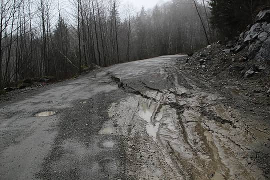 2015 (photo by trailchick) 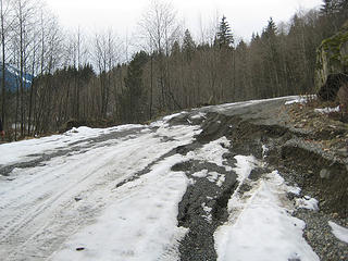 2009 (photo by Aaron Pease) 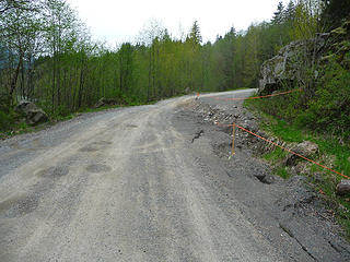 2008 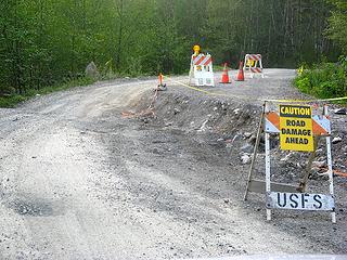 2008 (photo by Matt) 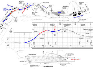 Annotated Middle Fork road plans in the area of the chronic slump by the CCC road
|
| Back to top |
|
|
CascadeRambler
CascadeRambler
Joined: 05 Feb 2010
Posts: 20 | TRs | Pics
Location: CascadeRambler |
An amazing thing happened at the "temporary" Mailbox parking area Saturday and Sunday; Saturday somehow 39 vehicles managed to park along the road without incident and on Sunday I counted 44 vehicles on my morning walk through the area, again with no apparent issues!
Oh and by the way, this included Kayakers and whitewater rafters.
I guess this just goes to show we are a pretty good bunch of folks that want to get along with everyone.
Nice job everybody!
- Ramblin the Cascade Range
- Ramblin the Cascade Range
|
| Back to top |
|
|
|
|


