| Previous :: Next Topic |
| Author |
Message |
Earthbound
Member


Joined: 25 Oct 2008
Posts: 16 | TRs | Pics
|
Myself (Doug Walsh), Scott Kindred and Andy Luks set out from Easy Pass on June 20th for a north side summit attempt on 4 peaks of the Ragged Ridge Mesachie, Katsuk, Kimtah, Cosho. We planned an aggressive 3 day itinerary, with the middle day involving summiting all 4 peaks. In retrospect, summiting all of these peaks in a single day would require perfect route-finding in complicated terrain, excellent endurance, the right conditions, and long days. We had 3 of those 4 conditions intact, but imperfect route-finding forced us to settle for just Kimtah and Cosho. Still, it was an amazing trip in stunningly beautiful country. I am surprised more people dont climb these peaks from the north side, as it is WAY prettier and the climbing is more esthetic than the south side routes. If I were to do this trip again, Id plan on 4 days. From our camp, Kimtah and Cosho make a perfect day trip for one day, and then Mesachie and Katsuk would go on another day quite well. You gotta go early in the year though. Otherwise, moat issues at Mesachie/Katsuk col could be prohibitive. Scott and Andy were both commenting how great a ski trip this would be, as all the unpleasant scree/talus we experienced (it wasnt really that bad actually) would not be an issue when snow cover is adequate.
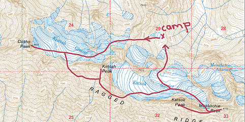 Tour de Ragged Ridge. Intended itinerary on day 2 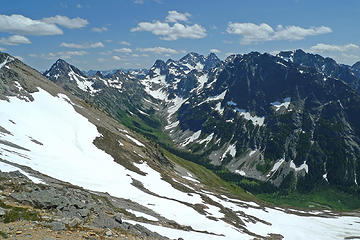 Fisher Creek from Kitling Col 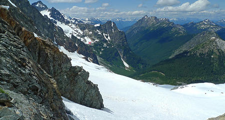 Panther Creek from Kitling Col. "X" marks our camp. 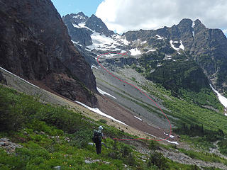 Spying the Route 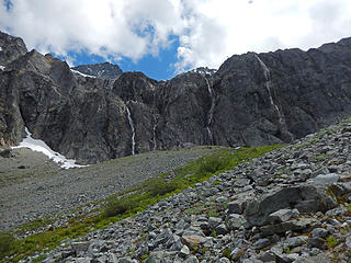 Waterfalls off Katsuk Glacier 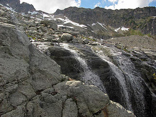 Water from Katsuk Glacier 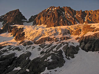 Sunset on Katsuk Glacier, with Mesachie and Katsuk visible 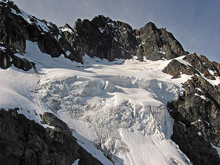 Seracs on Kimtah Glacier 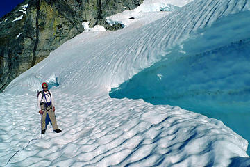 Scott below dicey snow bridge crossing. Our prints in snow behind Scott. 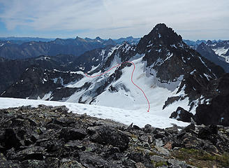 Kimtah from Cosho 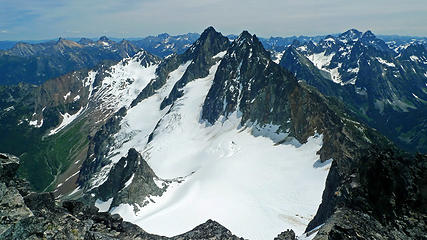 Mesachie and Katsuk from Kimtah 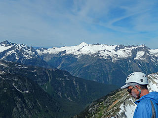 Summit of Kimtah 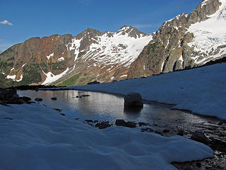 Mountain Reflections
|
| Back to top |
  
|
|
scottk
Member
Joined: 09 Jul 2013
Posts: 47 | TRs | Pics
|
|
scottk
Member
|
 Wed Jul 01, 2015 9:03 am |
|
|
Thanks for the great trip, Doug and Andy. For folks comfortable with a couple of short sections of steep snow on the Kimtah Glacier this is a much more elegant approach to climb Kimtah and Cosho in particular. It would be even more elegant on skis. The seracs and crevasses on the Kimtah glacier would be no issue on a normal snow year in June. Given that we couldn't find any trip reports that crossed over the col leading to Katsuk Glacier I'd really like to go back and see if it goes. Perhaps there's a ski trip in my future...
|
| Back to top |
|
|
Magellan
Brutally Handsome

Joined: 26 Jul 2006
Posts: 13117 | TRs | Pics
Location: Inexorable descent |
|
Magellan
Brutally Handsome
|
Wed Jul 01, 2015 9:09 am |
|
|
Sweet trip fellas.  Something to consider for the future. Something to consider for the future.
|
| Back to top |
|
|
DIYSteve
seeking hygge

Joined: 06 Mar 2007
Posts: 12655 | TRs | Pics
Location: here now |
|
DIYSteve
seeking hygge
|
Wed Jul 01, 2015 10:26 am |
|
|
Sweet
We traversed the N side glaciers on this high route in 2012, going lower than OP, and camping on the precipice of a promontory c. 1.5km NNNE of Kimtah summit. We named the spot "Camp Wow!"
|
| Back to top |
|
|
Earthbound
Member
Joined: 25 Oct 2008
Posts: 16 | TRs | Pics
|
Thanks BigSteve. Your trip report was what gave me the idea for this trip.
|
| Back to top |
|
|
DIYSteve
seeking hygge
Joined: 06 Mar 2007
Posts: 12655 | TRs | Pics
Location: here now |
|
DIYSteve
seeking hygge
|
Wed Jul 01, 2015 5:45 pm |
|
|
Cool Gotta get in there with skis one of these years
|
| Back to top |
|
|
raising3hikers
Member
Joined: 21 Sep 2007
Posts: 2344 | TRs | Pics
Location: Edmonds, Wa |
great way to do those peaks
|
| Back to top |
|
|
JoshK
Member
Joined: 13 Apr 2010
Posts: 11 | TRs | Pics
|
|
JoshK
Member
|
Tue Jul 07, 2015 12:47 am |
|
|
"Elegant" is in the eye of the beholder I suppose. Count me as the odd one who thought the long south side traverse, levitating above Fisher Creek, with Logan and Goode across the valley was sweet! Not to mention goat trails across rocky buttress, covered in cool dry-side flora. More engaging than yet another glacier walk imo.
Awesome trip though, certainly not trying to disparage! I just have to give the south side some respect, it's super beautiful and everybody always bags on it. 
|
| Back to top |
|
|
|
|
You cannot post new topics in this forum
You cannot reply to topics in this forum
You cannot edit your posts in this forum
You cannot delete your posts in this forum
You cannot vote in polls in this forum
|
Disclosure: As an Amazon Associate NWHikers.net earns from qualifying purchases when you use our link(s). |


