| Previous :: Next Topic |
| Author |
Message |
MomvsWild
Member


Joined: 08 Jun 2014
Posts: 11 | TRs | Pics
Location: Bellevue, Wa |
Larch are at their peak, so we had a wonderful trip up Mt Carne, across the high traverse and camping at upper ice lake. The next day we summited Mt Maude via S Slope and hiked out from Leroy Basin to Phelps Creek trail.
Note: Road is very bumpy to Trail head. Bring high clearance vehicles.
NO RUNNING WATER AT LEROY BASIN. If you are going up Maude this way, make sure you pump on the way in Leroy Creek trail. By the campsites/toilet the creek is dry!
|
| Back to top |
  
|
|
Gimpilator
infinity/21M

Joined: 12 Oct 2006
Posts: 1684 | TRs | Pics
Location: Edmonds, WA |
Last week, I found the creek by the Leroy campsite dry as well, however if you follow it downstream for 100 yards, there is a good amount of flowing water. In fact, I even found a trail from that spot back up to the camps.
|
| Back to top |
|
|
HitTheTrail
Member

Joined: 30 Oct 2007
Posts: 5455 | TRs | Pics
Location: 509 |
How about water sources in Carne Basin and along the high route (Box Creek and Chipmunk Creek)?
|
| Back to top |
|
|
Gimpilator
infinity/21M
Joined: 12 Oct 2006
Posts: 1684 | TRs | Pics
Location: Edmonds, WA |
Water can likely be found in Chipmunk creek if you drop a couple hundred feet below the trail, and it can definitely be found in the Box Creek meadows that the trail remnant passes through.
|
| Back to top |
|
|
wanderwild
Member

Joined: 21 Jun 2004
Posts: 333 | TRs | Pics
Location: Seattle, WA |
Here is the water in Carne Basin from this last Saturday (10/3). It is there, but just super shallow and you gotta find the best spots to filter. There's water though.
"Whatever your mountain, climb on."
"Whatever your mountain, climb on."
|
| Back to top |
|
|
Odysseus
Hammer

Joined: 29 Jun 2012
Posts: 11 | TRs | Pics
Location: Eastern Cascades |
|
Odysseus
Hammer
|
 Tue Oct 06, 2015 11:46 am |
|
|
I you camped out at Upper Ice Lakes you violated a Forest Service Closure Order. You camped inside a closed area. Fine max $5000.00 or imprisonment for not more then six months. Did you call the Forest Service to confirm conditions first?
|
| Back to top |
|
|
Gimpilator
infinity/21M
Joined: 12 Oct 2006
Posts: 1684 | TRs | Pics
Location: Edmonds, WA |
| Odysseus wrote: | | You camped inside a closed area. Fine max $5000.00 or imprisonment for not more then six months. Did you call the Forest Service to confirm conditions first? |
The following was copied from my own comment on my own trip report...
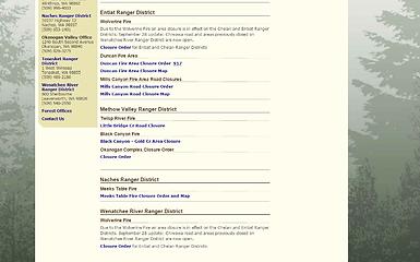
We saw the closure order from September 17, however the Ranger on the phone told us that "not everything on the website has been updated yet" and then later we saw the September 28 Wolverine Fire update posted which says, "Chiwawa Road and areas previously closed on Wenatchee River Ranger District are now open". That's kind of vague, but we saw nothing at the trailhead which indicated any closures.
 screen capture
|
| Back to top |
|
|
mbravenboer
Member
Joined: 20 Oct 2013
Posts: 1422 | TRs | Pics
Location: Seattle |
I didn't want to nitpick in the other post, so I didn't comment on it further, but since it is being discussed again here: the statement "Chiwawa Road and areas previously closed on Wenatchee River Ranger District are now open" is in principle consistent with the closure order published. The boundary of the Wenatchee River Ranger District and the Entiat District runs across the ridge. The *Wenatchee* areas are open, the Entiat area is not.
I really wish though that the FS websites would publish a clear map with their verbal description, which can be very hard to sort out.
I did find this, which appears to show the closure area in purple. I'm not sure if this is kept up to date when the closure area changes.
http://usfs.maps.arcgis.com/apps/webappviewer/index.html?id=bd6c1ad8feb541e7952fc097273f926f
If I understood all the info correct (didn't call any ranger stations to confirm), then technically you can go to Maude, but you would be exactly on the boundary of the area, so perhaps better to stay out of there.
(edit: you need to zoom in and do some other random things to see the purple closure area)
|
| Back to top |
|
|
Obi Tony Kenobi
Waterfall Crazy!

Joined: 25 Jun 2007
Posts: 1899 | TRs | Pics
Location: Marysville, WA |
| Odysseus wrote: | | I you camped out at Upper Ice Lakes you violated a Forest Service Closure Order. You camped inside a closed area. Fine max $5000.00 or imprisonment for not more then six months. Did you call the Forest Service to confirm conditions first? |
So I was another backpacker that went into the Spider Meadow area this weekend. I called the Wenatchee Ranger Station and everything was cleared. Even driving up I stopped at any signage just to make sure and on the way up Chiwawa Road read the sign posting looking for any closures up on Leroy Creek to the Ice Lakes area and there was nothing. Nothing that said anything about those areas being closed even looking at the map that was posted.
Now I didn't go up there and I know there were lots of backpackers along the ridge just by seeing their occasional headlamp across from the Spider Knob area and there is no way every single person missed the signs for closures. So the problem isn't the backpackers, it is the FOREST SERVICE by NOT MAKING it clear that the AREA is still CLOSED
Even if it is not in the Wenatchee Forest Service jurisdiction, they know very well that is a popular route up to Ice Lakes and they should be just as responsible for posting closure signs for areas accessible from their area.
I swear what is going on here on NWHikers with the self-righteous, elitist attitude?
|
| Back to top |
|
|
Opus
Wannabe

Joined: 04 Mar 2006
Posts: 3700 | TRs | Pics
Location: The big rock candy mountain |
|
Opus
Wannabe
|
Tue Oct 06, 2015 2:48 pm |
|
|
| Obi Tony Kenobi wrote: | | Now I didn't go up there and I know there were lots of backpackers along the ridge just by seeing their occasional headlamp across from the Spider Knob area and there is no way every single person missed the signs for closures. So the problem isn't the backpackers, it is the FOREST SERVICE by NOT MAKING it clear that the AREA is still CLOSED |
I did the high-route that same weekend and also camped at Ice Lakes. I checked the website first and didn't see a single sign at the trailhead or anywhere along the route indicating the lakes were still off limits. Afterwards I was informed they were closed by a ranger who had camped out in Leroy Basin and was doing the high route. Perhaps adding signage? I don't think anyone there intentionally violated the order, it was just very unclear which areas were still off limits.
|
| Back to top |
|
|
AlpineRose
Member
Joined: 08 May 2012
Posts: 1953 | TRs | Pics
|
There is nothing elitist about looking at a map of a closure area (if one exists, of course) before one's trip, then looking at a map of where you plan to go to determine if your route enters through a closed area. This is called trip planning. It is also known as plain old common sense. The Forest Service is not your mommy-daddy.
|
| Back to top |
|
|
Malachai Constant
Member

Joined: 13 Jan 2002
Posts: 16092 | TRs | Pics
Location: Back Again Like A Bad Penny |
Most of the posts here violate the no spray in trip reports policy. 
"You do not laugh when you look at the mountains, or when you look at the sea." Lafcadio Hearn
"You do not laugh when you look at the mountains, or when you look at the sea." Lafcadio Hearn
|
| Back to top |
|
|
littlebit
Member

Joined: 23 Jun 2012
Posts: 39 | TRs | Pics
Location: Winthrop WA |
Ice lakes is one of my favorite areas as is (was?) the Entiat river valley. According to the fire maps, the Wolverine fire burned a good chunk of the Entiat. How bad does it look?
|
| Back to top |
|
|
wanderwild
Member
Joined: 21 Jun 2004
Posts: 333 | TRs | Pics
Location: Seattle, WA |
I took these photos from the ridge between Carne Mountain and Mt. Maude this last Saturday. It looks pretty bad (St. Helens-esque...). I know there was already some burn in that area though, based on Google Earth imagery. Haven't personally been that far up the Entiat though, so I don't know how much worse this is now than whatever was there previously. In the last photo you can see the fire still burning below Ice Lakes, but looks like it was pretty close to going out.
"Whatever your mountain, climb on."
"Whatever your mountain, climb on."
|
| Back to top |
|
|
mbravenboer
Member
Joined: 20 Oct 2013
Posts: 1422 | TRs | Pics
Location: Seattle |
|
| Back to top |
|
|
|
|


