| Previous :: Next Topic |
| Author |
Message |
Nancyann
Member


Joined: 28 Jul 2013
Posts: 2319 | TRs | Pics
Location: Sultan Basin |
|
Nancyann
Member
|
 Sun Oct 18, 2015 6:38 pm |
|
|
Yesterday our little Motley Crew made it up to Captain Point from the abandoned Kelley Creek trail via the new awesome trail the Volunteers of America are building. (Thanks VOW!)
We did not see a clear path heading towards Johnson Ridge like I had heard about. Of course, why would it be clear when no one uses it, but has anyone done this little stretch of trail?
Also, I was looking at an old Pargeter Map which shows a trail going along Valhalla Mt. from the PCT and over to Captain Point. Anyone ever done this? It looked intriguing!
Thanks in advance for any helpful information. 
|
| Back to top |
  
|
|
Conrad
Meadow bagger

Joined: 25 Aug 2006
Posts: 2298 | TRs | Pics
Location: Moscow, ID |
|
Conrad
Meadow bagger
|
Sun Oct 18, 2015 7:08 pm |
|
|
I explored that area one day, but it was 20+ years ago and probably won't add much to what you already saw. I hiked the usual trail to Scorpion Mtn, then found the unmapped trail (advertised in the 100 Hikes book at that time) heading S toward Captain Point. It petered out quickly, but cross-country travel S on the ridge to the pretty basin just NE of Captain Point wasn't hard. From there I found more trail heading E along the ridge, but it was already sluffing badly in ~1992 in the soft steep meadow on the S side of the ridge. I followed it to a helipad on the high point ~1/2 mile E of Captain Point, where it seemed to disappear. There is a stretch of logging road along the saddle (between Captain Point and Valhalla Mtn) a bit E of where I stopped.
|
| Back to top |
|
|
Joey
verrry senior member

Joined: 05 Jun 2005
Posts: 2799 | TRs | Pics
Location: Redmond |
|
Joey
verrry senior member
|
Sun Oct 18, 2015 7:31 pm |
|
|
|
| Back to top |
|
|
Nancyann
Member
Joined: 28 Jul 2013
Posts: 2319 | TRs | Pics
Location: Sultan Basin |
|
Nancyann
Member
|
Sun Oct 18, 2015 7:36 pm |
|
|
Thanks, Conrad, that is interesting. I thought I saw the way trail heading east up the ridge at Captain Point. I wonder if the helipad was for logging? I also saw the logging road in the saddle between Valhalla and Captain Point.
We'll probably have better luck finding the way trail from the Scorpion Mt. end of it. It takes a while to get through the 1,000 blowdowns coming up from Kelley Creek. 
|
| Back to top |
|
|
Nancyann
Member
Joined: 28 Jul 2013
Posts: 2319 | TRs | Pics
Location: Sultan Basin |
|
Nancyann
Member
|
Sun Oct 18, 2015 7:45 pm |
|
|
Thanks Joey, those are great directions! I wish we had them yesterday. But then we would have had gone farther and had three hours of headlamp hiking out instead of two. Having map and compass is very important in this area and yes, we were taking careful notes where we came out on the ridge for our trip back!
|
| Back to top |
|
|
Joey
verrry senior member
Joined: 05 Jun 2005
Posts: 2799 | TRs | Pics
Location: Redmond |
|
Joey
verrry senior member
|
Sun Oct 18, 2015 7:50 pm |
|
|
| Nancyann wrote: | | We'll probably have better luck finding the way trail from the Scorpion Mt. end of it. |
Maybe not.
Coming from Scorpion I never saw any visible sign where the trail dropped off the ridge to the east. Just off the ridge crest the first ~50 feet of trail is overgrown with brush. If you are standing just below that patch of brush after snowmelt and before green up then you can just barely maybe see the faintest impression of the trail under the brush. I seem to recall seeing a switchback.
|
| Back to top |
|
|
cartman
Member
Joined: 20 Feb 2007
Posts: 2800 | TRs | Pics
Location: Fremont |
|
cartman
Member
|
Sun Oct 18, 2015 8:17 pm |
|
|
I traveled this route from Scorpion to Captain Pt. about nine yrs. ago.
The trail was very obvious coming off Scorpion and thru the meadows below to the south. Then it entered a S-trending forested ridge, where it was still obvious for a ways but with numerous blowdowns. The farther toward Captain Pt we went, the more obscure the trail became, then we lost it. To summit Captain was all off-trail.
Apparently the trail went all the way from Johnson Ridge to Scenic, but is going back to nature past Scorpion.
|
| Back to top |
|
|
Nancyann
Member
Joined: 28 Jul 2013
Posts: 2319 | TRs | Pics
Location: Sultan Basin |
|
Nancyann
Member
|
Sun Oct 18, 2015 8:48 pm |
|
|
This is even more interesting, Cartman. We came through the blowdowns from Kelley Creek yesterday, and there is flagging to help stay on course. We popped out onto the ridgetop into the lovely basin just below Captain Point that Conrad was talking about and you can see a faint way trail that goes on up the east ridge of Captain Point.
When you approached the blowdown (actually it looked more like a massive avalanche) area, there was no doubt not any flagging to show where the old trail was before it became obliterated, so maybe you missed where it went into the basin.
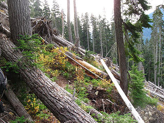 image 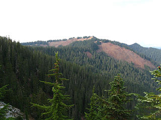 Scorpion Mt. From the abandoned trail
|
| Back to top |
|
|
Joey
verrry senior member
Joined: 05 Jun 2005
Posts: 2799 | TRs | Pics
Location: Redmond |
|
Joey
verrry senior member
|
Sun Oct 18, 2015 9:12 pm |
|
|
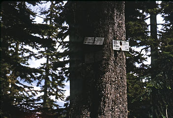
| Nancyann wrote: | | It's my understanding from reading Joey's old TR, that the trail which follows blazes runs along the right (east side) of this ridge north to Scorpion. |
The map I posted showed where there is an old USFS sign on the ridge north of Captain Point. Here is a pic.
 Sign_north_of_Captain_Point
|
| Back to top |
|
|
Nancyann
Member
Joined: 28 Jul 2013
Posts: 2319 | TRs | Pics
Location: Sultan Basin |
|
Nancyann
Member
|
Sun Oct 18, 2015 10:18 pm |
|
|
Ok! Thanks for clarifying for us.
Joey wrote: "there was a trail all along that ridge line. The east end was the crest trail"
Cartman wrote:"Apparently the trail went all the way from Johnson Ridge to Scenic"
Oh, to have those days back again. That must have been a very nice ridge ramble once upon a time.
|
| Back to top |
|
|
Dalekz
Member
Joined: 01 Mar 2002
Posts: 487 | TRs | Pics
|
|
Dalekz
Member
|
Mon Oct 19, 2015 9:12 am |
|
|
I have done the old trail going east of Captain Point toward the crest trail. It was easy to find once out of the clearcut where the road comes out at the pass east of Captain Point.
Found this trail marker along the way (dark picture)
 30 Captain point east July 1993 --022d 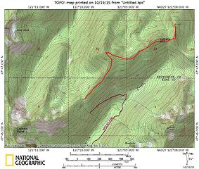 000b Captain point east
|
| Back to top |
|
|
RichP
Member

Joined: 13 Jul 2006
Posts: 5634 | TRs | Pics
Location: here |
|
RichP
Member
|
Mon Oct 19, 2015 12:08 pm |
|
|
|
| Back to top |
|
|
wolffie
Member

Joined: 14 Jul 2008
Posts: 2693 | TRs | Pics
Location: Seattle |
|
wolffie
Member
|
Mon Oct 19, 2015 12:10 pm |
|
|
| Nancyann wrote: | | 1,000 blowdowns coming up from Kelley Creek. |
Between the saddle and the avalanche area are about 60 blowdown (counting everything, even the trivial ones) with about 18 "significant" ones. Then I lost count -- I panicked, darkness coming on, looking for my corgi who disobeyed and made it through much of the avy debris on his own -- I estimate 100-120 total blowdown with maybe 25 of them "significant" and only a couple RABs (Right Awkward Buggers). It is not too hard, especially since we took out the low-hanging fruit and swamped-out the remaining RABs, and a corgi can do most of it. One or two you have to slither under. Somebody has sawn-out some of the big logs in the avvy chute, but clearing that will be a major job.
We followed the new VOW(?) trail from the west end of Iron Goat (the horseshoe tunnel). This joins an older trail that crosses Kelley Creek, a good tread, but a very short section at the junction has diverted and looks quite obscure from the east side (the old Kelley Creek Trail). Returning, I would've walked right past it in the dark, except the dog was leading -- the nose beats a headlamp any night.
Not much water in Kelley Creek; a dry-foot rockhop ford.
Wow, it would be interesting to try to follow that "North Crest Cutoff" from Captain Point all the way to the PCT. Al sniffs a project coming on...
Ooh. I remember now. We turned back at the clearing N of Captain Point, at about 5000'. Looking SSE, there looked like a clear trail coming off Captain Point down its east ridge, in open meadow just below the crest on the N side; maybe that's the cutoff.
Some people have better things to do with their lives than walking the dog. Some don't.
Some people have better things to do with their lives than walking the dog. Some don't.
|
| Back to top |
|
|
Nancyann
Member
Joined: 28 Jul 2013
Posts: 2319 | TRs | Pics
Location: Sultan Basin |
|
Nancyann
Member
|
Mon Oct 19, 2015 1:21 pm |
|
|
We'd still be up there if it wasn't for Al.
|
| Back to top |
|
|
RichP
Member
Joined: 13 Jul 2006
Posts: 5634 | TRs | Pics
Location: here |
|
RichP
Member
|
Tue Oct 20, 2015 9:21 pm |
|
|
I walked the trail from Scorpion to Captain Point today. It's in surprisingly good shape and easy to follow.
|
| Back to top |
|
|
|
|


