| Previous :: Next Topic |
| Author |
Message |
mbravenboer
Member


Joined: 20 Oct 2013
Posts: 1422 | TRs | Pics
Location: Seattle |
This day was another failed Mt Hinman attempt that turned into a beautiful plan B. I previous naively tried to get into this area in winter, which turned into a trip to Tank Lakes. Now in summer with record absence of snow, I thought this would be fairly doable. We got to the Hinman ridge above the upper La Bohn Lake, but we hit a nasty rock that my dog could not conquer. I didn't really want to drag her up and risk accidents, and after trying to find other options for a while, I decided to give up and go down to Chain Lakes as plan B. Unless I took the wrong route (which I doubt: there were a few cairns), Mt. Hinman via this route is probably not class dog, unless you can easily carry your dog, or your dog is a mountain goat (see photos of the spot below)
Back to the morning: We started at 5am at the East Fork Foss trailhead, which was already covered up for winter. I wanted to start early so that we would have enough time to make it wherever we wanted. There was a car at the trailhead, and about an hour in I saw the tent of a couple with two dogs that I met later on the way out.
We arrived at the bridge across the river after 1h45. The route up the boulder field was easier to find than in winter, but still a bit messy. The section to Jade Lake was steeper than I remenbered. It's also looong. Somehow I keep misjudging how far it is. It took me another 1h45 to reach the lake. We crossed the inlet of Jade Lake and continued to the Necklace Cabin. I made a mistake here and took the trail to Al Lake. To go deeper into the valley, you have to follow the trail that runs right by the cabin. There are many side-trails in the valley, but for the reminder it was fairly clear to me which one to follow. It took me another hour to get to the end of the valley.
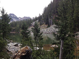 Jade Lake 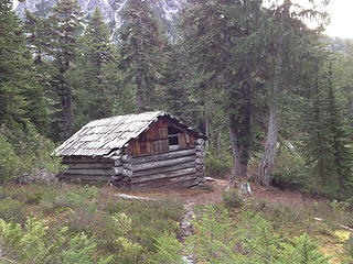 Necklace Cabin 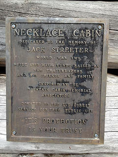 Necklace Cabin 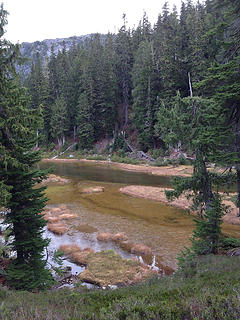 Emerald Lake 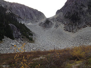 At the end of the Necklace Valley the La Bohn Gap awaits 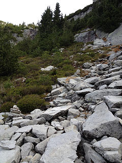 Waterfall bootpath is generously marked by cairns 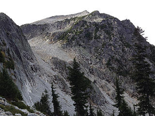 View on the snow-free La Bohn Gap and La Bohn Peak from the waterfall bootpath 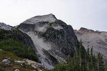 La Bohn Gap and La Bohn Peak from the outlet of the lowest La Bohn Lake 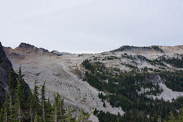 Foehn Lake, Tahl Lake, Otter Point area (hiked there last winter)  ). It took quite a bit of energy to try to find an alternative route. ). It took quite a bit of energy to try to find an alternative route.
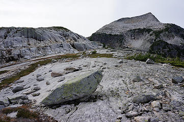 Slabs at the La Bohn Lakes 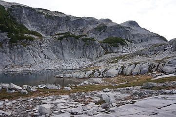 Middle La Bohn Lake 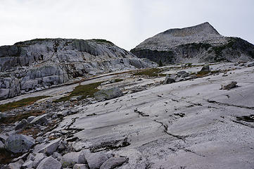 Slabs at the La Bohn Lakes 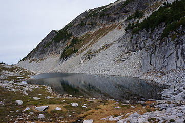 Middle La Bohn Lake 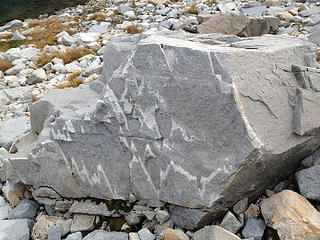 Mountain rock 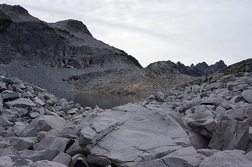 Highest La Bohn Lake 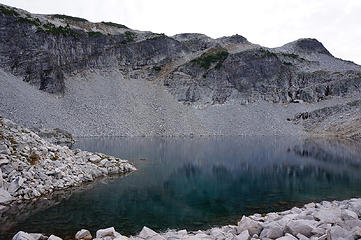 Highest La Bohn Lake 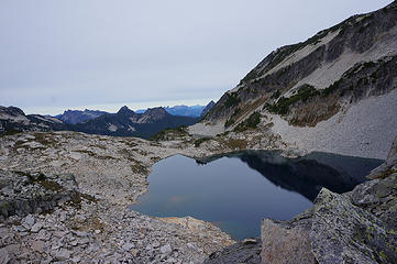 Highest La Bohn Lake 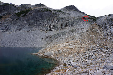 Circled in red is the point where turned around above the highest La Bohn Lake 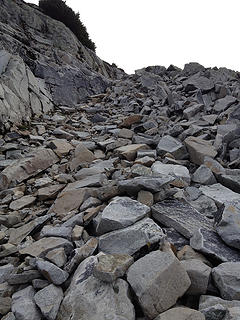 Steepish gully before the point where we turned around 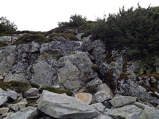 The rock does not look very steep in this photo, but this is where we got turned around. Liesl could not climb it. For humans it's relatively straightforward, though steep and exposed enough that you do not want to carry a dog up. 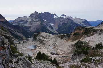 New objective: Chain Lakes, idea was to go the viewpoint in the middle to enjoy the Middle Fork Snoqualmie valley 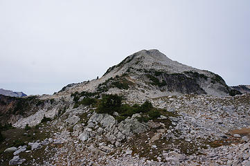 La Bohn Peak from La Bohn Gap 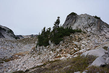 Pt 6022 from south. 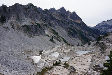 Chain Lakes, we'll get closer to the big rock on the slabs in the middle 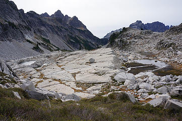 Huge slab at Chain Lakes 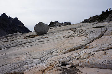 Rock determined to stay 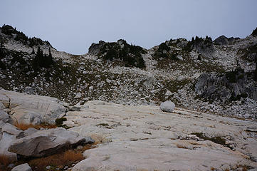 Looking back at the La Bohn Gap from Chain Lakes 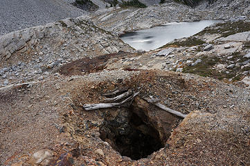 Deep mine (could not see the bottom) in the middle of the Chain Lakes 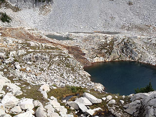 Flow of rocks from the mine 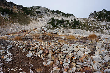 This looked initially like a designated camp-site, but there was a lot of glass and order old garbage. Probably it was the shelter of the miners? 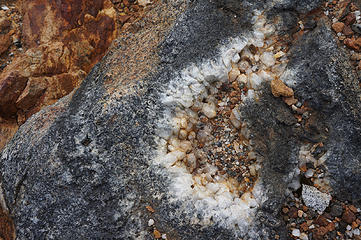 The area does have some interesting rocks. 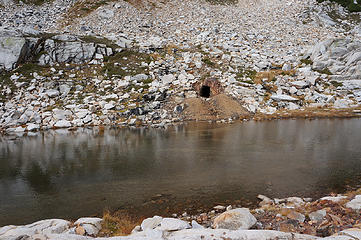 Another mine 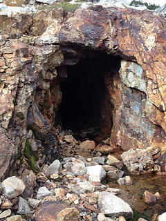 Mine, closeby 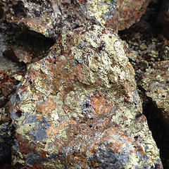 Not an expert, but this looks like gold. Do you feel feverish already? 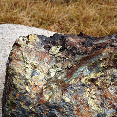 Gold? 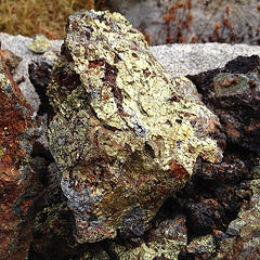 Gold? 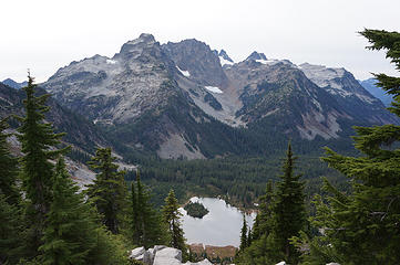 Summit Chief, Chimney Rock, Overcoat Peak, Lake Williams in foreground 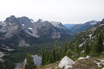 Middle Fork Snoqualmie Drainage with Lake Williams in foreground 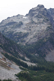 Dutch Miller Gap 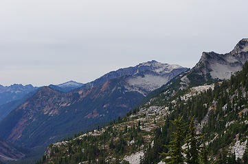 Big Snow Mtn (high peak in middle) and Tank Lakes area (right) 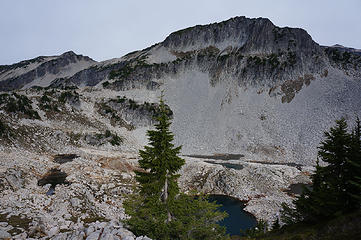 Chain Lakes looking towards Mt Hinman. Right-top is perhaps true summit of Hinman in far distance 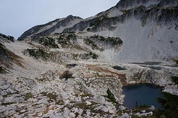 Chain Lakes 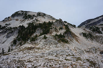 La Bohn Peak (from South) 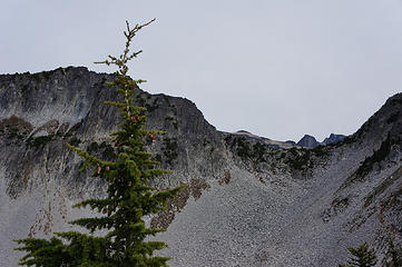 True summit of Hinman visible through the gap to Lake Rowena 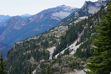 Closer view of Tank Lakes area. A traverse here might be relatively easy at 5400ft? 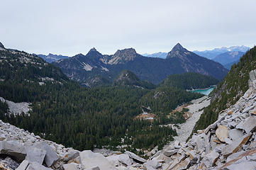 Necklace Valley from gap. Big Lake left is Locket Lake. Middle barely visible is Jade Lake, middle foreground is Opal Lake, right is first Cloudy Lake and then most showy is Lake Ilswoot. In distance is Mt. Baker and Monte Cristos with Columbia Glacier. 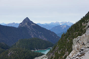 Lake Ilswoot from La Bohn Gap 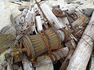 Remains in the La Bohn Gap 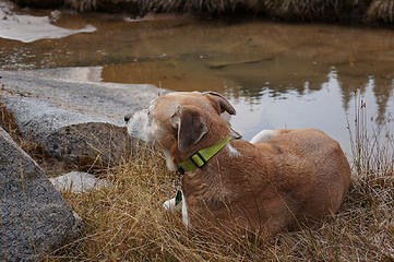 Liesl chilling out a bit during our break back in the valley.
 zimmertr zimmertr
zimmertr |
| Back to top |
  
|
|
RichP
Member

Joined: 13 Jul 2006
Posts: 5634 | TRs | Pics
Location: here |
|
RichP
Member
|
 Sat Oct 24, 2015 4:35 pm |
|
|
I believe these are the trees you mention.
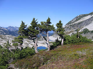 Attempt to duplicate Ed Cooper's photo of "dwarfed, wind-bent alpine zone conifers" in Beckey's guide.
|
| Back to top |
|
|
olderthanIusedtobe
Member
Joined: 05 Sep 2011
Posts: 7708 | TRs | Pics
Location: Shoreline |
There's gold in them that hills! Great, now you're going to spark a new gold rush.
Your early turn around below Hinman spared you from reaching the part that is like walking on multiple layers of dinner plates stacked on top of each other. It wasn't the most delightful experience I've had the pleasure of enjoying.
|
| Back to top |
|
|
mbravenboer
Member
Joined: 20 Oct 2013
Posts: 1422 | TRs | Pics
Location: Seattle |
| RichP wrote: | | I believe these are the trees you mention. |
Yes, exactly 
| olderthanIusedtobe wrote: | | dinner plates |
Yeah, I was curious about that. I read about the nasty rocks in the reports, and was earlier planning to do it early in the year with more snow (but that didn't work out). Until my turnaround spot the rocks weren't that bad. I assume it gets quite different when you reach the real Hinman slopes.
| olderthanIusedtobe wrote: | | Great, now you're going to spark a new gold rush. |
As long as it is a 20 mile hike roundtrip with some scrambling involved, I think we'll be okay .
I found some history information in these two great threads: https://www.nwhikers.net/forums/viewtopic.php?t=16370 and https://www.nwhikers.net/forums/viewtopic.php?t=11448 . I doesn't mention they were mining for gold though. Maybe I confused it?
I was getting curious how this worked in the past. The traces of cables in the Necklace Valley indicate what kind of infrastructure was needed beyond just the mine claim (apparently used for supplies). Was all this land basically free for anybody to abuse? Who regulated this at the time? I suppose nobody?
|
| Back to top |
|
|
mbravenboer
Member
Joined: 20 Oct 2013
Posts: 1422 | TRs | Pics
Location: Seattle |
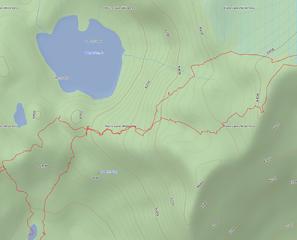
I was surprised by the obstacle I ran into, in particular because it is so popular these days (I've read several Hinman reports from this year). I went back and reviewed some reports to see if anything shows up, and the trail report of this trailrunner (Eve on WTA) was interesting. She offered a GPS track, which looks drawn, but she is quite clear about going up between the La Bohn Lakes, rather than south of the upper one.
Has somebody used this route before? The blue track is mine, the red one is hers. I wonder if I need to go back next year with or without dog .
|
| Back to top |
|
|
olderthanIusedtobe
Member
Joined: 05 Sep 2011
Posts: 7708 | TRs | Pics
Location: Shoreline |
I took your route. I eyeballed the route of the GPS track you posted. Looked like steep talus and not very inviting to me.
|
| Back to top |
|
|
puzzlr
Mid Fork Rocks

Joined: 13 Feb 2007
Posts: 7220 | TRs | Pics
Location: Stuck in the middle |
|
puzzlr
Mid Fork Rocks
|
Sun Oct 25, 2015 4:48 pm |
|
|
I took slightly different routes up and down from La Bohn Gap (originating at Williams Lake) but the same through the steeper part. There were sporadic boot tracks that helped locate a route, but it wouldn't have been hard to find without the tread.
 Hinman route From La Bohn Gap 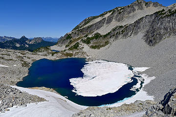 La Bohn lakes
|
| Back to top |
|
|
contour5
Member

Joined: 16 Jul 2003
Posts: 2963 | TRs | Pics
|
|
contour5
Member
|
Sun Oct 25, 2015 5:22 pm |
|
|
Very nice TR. That's a lot of walking in one day.
The trip from Williams to the Tanks is one of my favorite places...
|
| Back to top |
|
|
mbravenboer
Member
Joined: 20 Oct 2013
Posts: 1422 | TRs | Pics
Location: Seattle |
Thanks puzzlr & olderthanIusedtobe. That talus slope does not look very appealing on that photo, yes. Rather unforgiving with those cliffs below it. I'll try to make it an overnight one of the upcoming years so that I can look around with less time pressure there. Earlier in the year might be a good idea as well. I don't think Liesl is as good as climbing as the whippets, but they made it fine to the top in a June trip ( Schmidt Altitude's report).
| contour5 wrote: | | The trip from Williams to the Tanks is one of my favorite places... |
Yeah, that looked great. I'm eager to get back into that area to enjoy Tank Lakes in summer!
|
| Back to top |
|
|
OwenT
Member

Joined: 24 May 2014
Posts: 277 | TRs | Pics
Location: Moses Lake |
|
OwenT
Member
|
Wed Nov 04, 2015 3:19 pm |
|
|
That's some cool mineralization. Too bad your gold is probably pyrite or chalcopyrite.
|
| Back to top |
|
|
OwenT
Member
Joined: 24 May 2014
Posts: 277 | TRs | Pics
Location: Moses Lake |
|
OwenT
Member
|
Wed Nov 04, 2015 5:05 pm |
|
|
| Doppelganger wrote: | | What are the rules on recreational panning in that area? Assuming there is such a thing as recreational panning? |
Gold prospecting rules are usually pretty complicated, this is the one exception. Generally you can pan (talking about just pans here, no sluices, dredges, etc.) and collect minerals anywhere in a national forest, including Wilderness areas, at anytime of the year. I found that the dutch miller mine, probably that hole in the ground there, produced copper, silver, and gold. It was almost certainly lode gold (embedded in the rock), so if you're interested in finding some there then you'd need something to crush the ore pieces to fine bits then pan that. There's lots better places in WA to get easier gold though, you can pm me if you want to know more.
|
| Back to top |
|
|
mbravenboer
Member
Joined: 20 Oct 2013
Posts: 1422 | TRs | Pics
Location: Seattle |
OwenT, thanks for the info. I was hoping somebody would chime in on the gold, so I'm glad you pointed out some options. Copper ore did seem more likely given the location and copper mining history, but it seemed strange that there was no oxidation. I considered Pyrite, but I failed to see a more blocky structure.
I didn't bring any sample, but do you know how you can check what something is? Is there a specialist you can go to?
|
| Back to top |
|
|
yukon222
Member

Joined: 12 Mar 2007
Posts: 1893 | TRs | Pics
|
|
yukon222
Member
|
Thu Nov 05, 2015 12:07 pm |
|
|
| mbravenboer wrote: | | Earlier in the year might be a good idea as well. I don't think Liesl is as good as climbing as the whippets, but they made it fine to the top in a June trip ( Schmidt Altitude's report). |
Yes, when I did it with the whippets earlier in the season (late June), there was snow covering almost the entire way to the summit. At your turnaround spot with the rock area, I'm not positive but I think we traveled further to the right before ascending the ridge line. I don't remember any super steep snow covered sections, but perhaps the snow cover created easier slope angles.
Fun area - thanks for the TR!
|
| Back to top |
|
|
OwenT
Member
Joined: 24 May 2014
Posts: 277 | TRs | Pics
Location: Moses Lake |
|
OwenT
Member
|
Thu Nov 05, 2015 2:12 pm |
|
|
| mbravenboer wrote: | | do you know how you can check what something is? Is there a specialist you can go to? |
Assuming it's not gold (likely) then google "mineral flow chart" or "mineral ID chart". Something like that and you'll come up with lot's of different charts to help you narrow down what it is based on its physical properties.
| Doppelganger wrote: | | I seem to recall porcelain streaking tests, if you're lucky there might be some old plates in the garbage dump those miners left behind smile.gif Pyrite leaves black/dark streaks (due to the iron content?), while gold behaves differently... I do not recall what the behavior is, but since it's far more likely that you will see dark streaks that's probably all you need to know. Anything other than dark streaks, put it in the pack and don't lose it!
(Pure) Gold is also malleable, although this might require a hardness testing kit, or a relatively intimate familiarity with the hardness scale if you were to test by hand using whatever rough materials were available up there. Impurities may affect the results of the test, so that would be a consideration. |
These tests are easy to do. You can get closer just by looking at it too. We see that it's gold colored and it has a metallic luster. You've just narrowed it down to only a couple possibilities. The streak test is good. Porcelain is good to use but you might be able to get a streak on a white piece of paper for pyrite. Pyrite leaves a black/brown streak but gold's is just gold colored.
Hardness is something you can do just by scratching the sample with some stuff. Gold is pretty soft so you can scratch it with just about anything, pyrite however is about 6-6.5 on the Mohs hardness scale so a knife probably won't scratch it but a piece of quartz will.
If we think it's gold then try to smash it with something or cut it with a knife. Gold will just bend and squish, if it shatters or breaks though then it's not gold.
Maybe try posting your pictures and as much info about the stuff as you can on the Treasurenet Rocks & Gems forum, there's people there that know a lot more about this stuff than I do. It's a great site with forums for all your treasure hunting interests (including gold).
|
| Back to top |
|
|
OwenT
Member
Joined: 24 May 2014
Posts: 277 | TRs | Pics
Location: Moses Lake |
|
OwenT
Member
|
Thu Nov 05, 2015 3:41 pm |
|
|
| Doppelganger wrote: | | What was quartz on the scale, a perfect 7.0 right? I'm probably wrong, but where there is pyrite there is generally quartz. I've had very little success finding gold, certainly not enough to say whether you can count on quartz laying around in the same vicinity here in WA. |
Right, 7. Pretty much always quartz if there's gold. I'd agree in saying it likes pyrite too, quartz is found with lots of nice things.
|
| Back to top |
|
|
|
|
You cannot post new topics in this forum
You cannot reply to topics in this forum
You cannot edit your posts in this forum
You cannot delete your posts in this forum
You cannot vote in polls in this forum
|
Disclosure: As an Amazon Associate NWHikers.net earns from qualifying purchases when you use our link(s). |


