| Previous :: Next Topic |
| Author |
Message |
MuddyBoots
Member


Joined: 13 Nov 2015
Posts: 5 | TRs | Pics
|
It's mud season! That means it's time for the seasonal workers of the world to take their measly savings and do some traveling. I chose to head to southern Utah- my favorite place in the US, besides Washington- and soak up some vitamin D in Grand Staircase-Escalante. The drive from the Seattle-area took about 2.5 days, with an overnighter at Ancient Lakes along the Columbia River to kick things off. The sun didn't come out on the east side of the Cascades and we drove through an unexpected snowstorm near Salt Lake City causing me to think I might not ever see blue skies again. I got to see how pileups happen on the interstate, though- scary stuff- and got to put the ol' tire chains on during my sun-bound road trip. I reached Escalante the morning after the snowstorm and popped into Bryce Canyon NP to see the hoodoos dusted in snow before descending down into the canyons where temperatures were significantly warmer. The sun finally came out and it was time to take on Hole In The Rock Road, which I read horror stories about, but turned out to be fine (just the most extreme wash boarding I've ever experienced).
My boyfriend and I reached the Hurricane Wash trailhead after 30 miles of washboarding and found a parking lot of about 8 other cars and a young couple packing up their backpacks before hitting the trail. We chatted with them and remembered that it was spring break for most students. They told us they went to BSU (whatever that is) and asked "where do you guys go?" My boyfriend said, "to work."  We took the Hurricane Wash trail into Coyote Gulch, a canyon that eventually meets up with the Escalante River. I learned that this trail is actually one of the most visited areas in Escalante. Even still, I didn't see any signs of graffiti, vandalism, toilet paper flags, or LNT violations of any kind. It was really nice to see a popular place kept so pristine. I imagine whoever is willing to drive a fairly rough dirt road for thirty miles and then hike in water, is also willing to take care of the place they're in.
What is it about people disrespecting so many of the beautiful places we have here in Washington??? I think the answer has a lot to do with accessibility.
Anyway, the Coyote Gulch Trail is stunning. It was cool to see a fair amount of kids hiking around- good job parents! The hike is level the whole way except for some rocks you have to climb up and over and the Escalante River is reachable within a [long] day. We hiked in Hurricane Wash for about 5 miles and made camp at the confluence of Coyote Gulch and then dayhiked to the Escalante the next day. Spent three days, total, in the canyon but four would have been really nice. There are tons of cottonwood trees throughout that were leafing out bright green and will surely have a spectacular golden show in the fall.
I highly HIGHLY recommend this trip to anyone, especially inexperienced canyoneers. Hole In The Rock Road is also pretty fun with lots of interesting side roads. We added an extra day in the area to check out the nearby slot canyons, hit it on a Saturday, and were shocked to see how crowded it was (20-30 cars). Even still, everyone was respectful of the place and other hikers, and there was no sign of LNT violations. Impressive.
Here are some photos from the trip. There are more on my blog and I even had fun making a youtube video with some of the footage we got. Also, this is my first trip report here...HI EVERYONE!
We took the Hurricane Wash trail into Coyote Gulch, a canyon that eventually meets up with the Escalante River. I learned that this trail is actually one of the most visited areas in Escalante. Even still, I didn't see any signs of graffiti, vandalism, toilet paper flags, or LNT violations of any kind. It was really nice to see a popular place kept so pristine. I imagine whoever is willing to drive a fairly rough dirt road for thirty miles and then hike in water, is also willing to take care of the place they're in.
What is it about people disrespecting so many of the beautiful places we have here in Washington??? I think the answer has a lot to do with accessibility.
Anyway, the Coyote Gulch Trail is stunning. It was cool to see a fair amount of kids hiking around- good job parents! The hike is level the whole way except for some rocks you have to climb up and over and the Escalante River is reachable within a [long] day. We hiked in Hurricane Wash for about 5 miles and made camp at the confluence of Coyote Gulch and then dayhiked to the Escalante the next day. Spent three days, total, in the canyon but four would have been really nice. There are tons of cottonwood trees throughout that were leafing out bright green and will surely have a spectacular golden show in the fall.
I highly HIGHLY recommend this trip to anyone, especially inexperienced canyoneers. Hole In The Rock Road is also pretty fun with lots of interesting side roads. We added an extra day in the area to check out the nearby slot canyons, hit it on a Saturday, and were shocked to see how crowded it was (20-30 cars). Even still, everyone was respectful of the place and other hikers, and there was no sign of LNT violations. Impressive.
Here are some photos from the trip. There are more on my blog and I even had fun making a youtube video with some of the footage we got. Also, this is my first trip report here...HI EVERYONE!  March 20-29, 2016
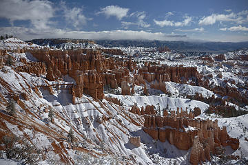 Bryce Canyon National Park, Utah 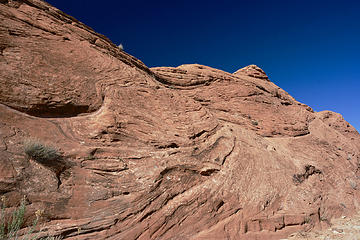 Ancient waves, Utah 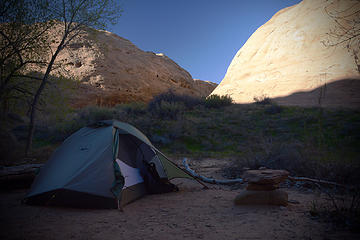 Coyote Gulch campsite, Utah 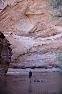 Dwarfed in Coyote Gulch, Utah 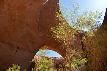 Jacob Hamblin Arch, Coyote Gulch, Utah 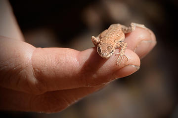 Sharing body heat after a cold swim 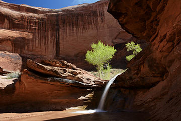 Coyote Gulch, Utah 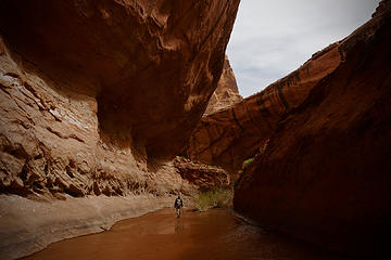 Coyote Gulch, Utah 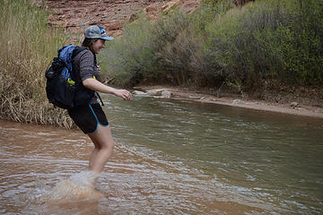 Coyote Gulch-Escalante River confluence, Utah 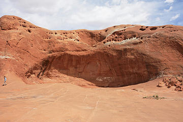 Dance Hall Rock, Utah 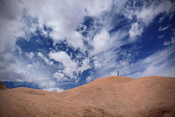 Slickrock and dramatic skies, Utah 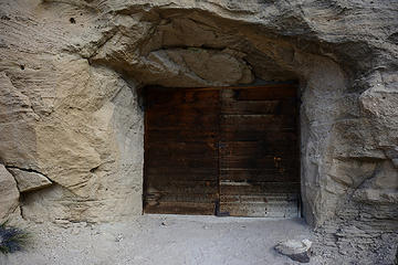 Batty Caves, Utah 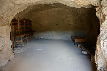 Abandoned mine, Batty Caves, Utah 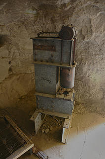 What is this? Abandoned mining area, Utah  BLM Land, Utah  Spooky Canyon, Utah 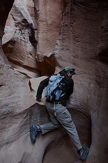 Peekaboo Canyon, Utah 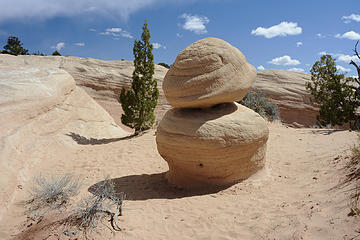 Devil's Garden, Utah 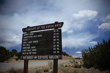 Hole In The Rock Road, Utah 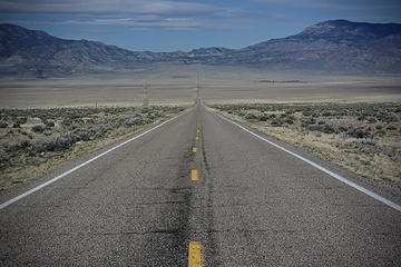 Hwy 21, Nevada 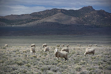 Great Basin sheep
|
| Back to top |
  
|
|
Frodo Barefoot
Member

Joined: 09 Apr 2015
Posts: 91 | TRs | Pics
|
|
| Back to top |
|
|
Sculpin
Member

Joined: 23 Apr 2015
Posts: 1383 | TRs | Pics
|
|
Sculpin
Member
|
 Tue Apr 05, 2016 3:31 pm |
|
|
Superb images! When I hiked the Escalante canyons a couple decades ago, finding the right place to start the hike was a bit challenging. And there was no one out there to ask. Now with Monument status and good signs, plus GPS, all those concerns are ancient history I suppose.
I remember a lot of poison ivy in those canyons, which typically barely causes a reaction on me, but I managed to get a small, itchy rash on my leg despite my best efforts to avoid it.
And for what its worth from a relative newbie, welcome to nwhikers!
Between every two pines is a doorway to the new world. - John Muir
Between every two pines is a doorway to the new world. - John Muir
|
| Back to top |
|
|
Brushbuffalo
Member

Joined: 17 Sep 2015
Posts: 1887 | TRs | Pics
Location: there earlier, here now, somewhere later... Bellingham in between |
Welcome to the forum, MB! Very fine TR.
In your pic. of the road sign I see the name Egypt. I drove there decades ago and hiked down to another real cool place called Scorpion Gulch.....much nicer than the name suggests!
btw, those students from BSU were most likely referring to Boise State U, just a long day's drive from Escalante (that is, sans snowy roads).
Passing rocks and trees like they were standing still
Passing rocks and trees like they were standing still
|
| Back to top |
|
|
Nancyann
Member

Joined: 28 Jul 2013
Posts: 2319 | TRs | Pics
Location: Sultan Basin |
|
Nancyann
Member
|
Tue Apr 05, 2016 10:43 pm |
|
|
Very nice first trip report! Your beautiful photos make me think this would be a great spring destination.
Your feeling that hikes which are difficult to get to don't have as much garbage because people appreciate how hard it was to get there is only partially correct. Sadly, I have seen an amazing amount of garbage left at places which are incredibly difficult to get to. It's really hard to understand why people choose to be such slobs...
I laughed when I read your comment about mud season. Up in the foothills where I live, mud season begins in September and if we are lucky, ends shortly after the Fourth of July!
Will take a look at your video when the internet is working a little better up here.
Glad you posted, and keep up the good work!
|
| Back to top |
|
|
olderthanIusedtobe
Member
Joined: 05 Sep 2011
Posts: 7709 | TRs | Pics
Location: Shoreline |
Nice first TR, thanks for sharing. Looks like a great trip.
|
| Back to top |
|
|
MuddyBoots
Member
Joined: 13 Nov 2015
Posts: 5 | TRs | Pics
|
Thanks for the warm welcome, guys.
Sculpin- I was reading about some of the more advanced canyoneering trips in the area and many of them said poison ivy is unavoidable the canyons. I think I saw some on this trail but it was still in dormancy and hadn't leafed out yet.
Brushbuffalo- There are SO many options of places to go off of Hole In The Rock!
Does anybody have any thoughts on what that machine in the old mine might be? Some kind of drill or crusher? There was no interpretive signage around the caves and I'm trying to figure it out without asking Google.
|
| Back to top |
|
|
Sculpin
Member
Joined: 23 Apr 2015
Posts: 1383 | TRs | Pics
|
|
Sculpin
Member
|
Wed Apr 06, 2016 10:57 am |
|
|
"Does anybody have any thoughts on what that machine in the old mine might be?"
I'm sure Jimbo and the other mining buffs on this site can answer that, they probably just haven't read this TR yet.
Between every two pines is a doorway to the new world. - John Muir
Between every two pines is a doorway to the new world. - John Muir
|
| Back to top |
|
|
|
|
You cannot post new topics in this forum
You cannot reply to topics in this forum
You cannot edit your posts in this forum
You cannot delete your posts in this forum
You cannot vote in polls in this forum
|
Disclosure: As an Amazon Associate NWHikers.net earns from qualifying purchases when you use our link(s). |


