| Previous :: Next Topic |
| Author |
Message |
christensent
Member


Joined: 05 Nov 2011
Posts: 658 | TRs | Pics
|
All other vehicles were parked at China Point (about 11 miles from the Daniel Trailhead). Unless you have a vehicle which you have experience floating on spring snowpacks, that's about it. Might get another two miles in a week or two, past that it's deep. I took it to a little past Scatter Creek leaving 2.5 miles of skiing to the trailhead. Didn't want to get stuck out in those meadows at the end with no winch points.
The roughly 6 flat miles from parking was a bit tedious, especially on the way out. Half a dozen stream crossings but otherwise skinned the whole way. Did anyone lose their boat?
Once past all the flat, I made a very poor decision to start up a narrow couloir hoping it'd come out at the base of the Daniel Glacier since I didn't know how people usually get up here. It turns out it actually just had a big crack full-width and was impassable. Skied back down 800 feet and found the correct route a little further up the valley
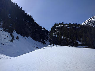 Do not go up this gully
Learning mountaineering: 10% technical knowledge, 90% learning how to eat
Learning mountaineering: 10% technical knowledge, 90% learning how to eat
|
| Back to top |
  
|
|
awilsondc
Member

Joined: 03 Apr 2016
Posts: 1324 | TRs | Pics
|
Wow. I admire your ability to do that on multiple levels... the vehicle approach, the skinning and skiing, snow camping, route finding... pretty crazy. Not many people can do that, especially solo! Great decision to turn back when you did too. Thanks for the post, always nice to know what the conditions and snow pack are like this time of year.
|
| Back to top |
|
|
RichP
Member

Joined: 13 Jul 2006
Posts: 5634 | TRs | Pics
Location: here |
|
RichP
Member
|
 Sun Apr 17, 2016 8:34 pm |
|
|
| awilsondc wrote: | | Wow. I admire your ability to do that on multiple levels... the vehicle approach, the skinning and skiing, snow camping, route finding... pretty crazy. Not many people can do that, especially solo! Great decision to turn back when you did too. Thanks for the post, always nice to know what the conditions and snow pack are like this time of year. |
+1
|
| Back to top |
|
|
mbravenboer
Member

Joined: 20 Oct 2013
Posts: 1422 | TRs | Pics
Location: Seattle |
That's dedication  Hope you a good time. Sounds like you made good decisions on the snow situation. Interesting to hear that there was still wind-loading happening. I kind of expected snow to be wet even at that elevation.
|
| Back to top |
|
|
Kat
Turtle Hiker
Joined: 05 Oct 2003
Posts: 2560 | TRs | Pics
|
|
Kat
Turtle Hiker
|
Mon Apr 18, 2016 4:43 am |
|
|
How was Scatter Creek, any pics? I'm interested in just how much it roars or is undercut during snow melt, but obviously you got thru it...
|
| Back to top |
|
|
christensent
Member
Joined: 05 Nov 2011
Posts: 658 | TRs | Pics
|
Scatter creek was maybe 3" deep, surprising.
Most creek crossings have nice ramps because of the snowmobile use in the winter.
Learning mountaineering: 10% technical knowledge, 90% learning how to eat
Learning mountaineering: 10% technical knowledge, 90% learning how to eat
|
| Back to top |
|
|
Kat
Turtle Hiker
Joined: 05 Oct 2003
Posts: 2560 | TRs | Pics
|
|
Kat
Turtle Hiker
|
Mon Apr 18, 2016 7:22 am |
|
|
Wow, not what I expected at all - thanks for the pic. re: snowmobiles - they're still out there for spring riding, I'll bet that snowmobilers were a good portion of the folks parked at China Point and they didn't expect jeep ruts this early.
|
| Back to top |
|
|
DIYSteve
seeking hygge

Joined: 06 Mar 2007
Posts: 12655 | TRs | Pics
Location: here now |
|
DIYSteve
seeking hygge
|
Mon Apr 18, 2016 7:57 am |
|
|
|
| Back to top |
|
|
christensent
Member
Joined: 05 Nov 2011
Posts: 658 | TRs | Pics
|
| BigSteve wrote: | | You ascended The Chasm? |
Most of it, but literally 100 feet below the big opening into sunshine there was a snow bridge that was not an acceptable risk.
The whole thing wasn't really an acceptable risk and I shouldn't have been in there at all.
Learning mountaineering: 10% technical knowledge, 90% learning how to eat
Learning mountaineering: 10% technical knowledge, 90% learning how to eat
|
| Back to top |
|
|
DIYSteve
seeking hygge
Joined: 06 Mar 2007
Posts: 12655 | TRs | Pics
Location: here now |
|
DIYSteve
seeking hygge
|
Mon Apr 18, 2016 8:41 am |
|
|
| christensent wrote: | | The whole thing wasn't really an acceptable risk and I shouldn't have been in there at all. |
There is a route from Hyas Lake to the saddle on the Pea Soup/Daniel Glacier divide. See the descent route in this TR. I'm not surprised to hear about chitty snowpack up high. This too shall pass.
|
| Back to top |
|
|
puzzlr
Mid Fork Rocks

Joined: 13 Feb 2007
Posts: 7220 | TRs | Pics
Location: Stuck in the middle |
|
puzzlr
Mid Fork Rocks
|
Mon Apr 18, 2016 11:17 am |
|
|
Very interesting early season trip. I'm impressed by your stamina and your vehicle!
|
| Back to top |
|
|
GaliWalker
Have camera will use

Joined: 10 Dec 2007
Posts: 4929 | TRs | Pics
Location: Pittsburgh |
|
GaliWalker
Have camera will use
|
Mon Apr 18, 2016 11:42 am |
|
|
| BigSteve wrote: | | There is a route from Hyas Lake to the saddle on the Pea Soup/Daniel Glacier divide. See the descent route in this TR. |
Isn't that the route he took, or something close to it?
|
| Back to top |
|
|
DIYSteve
seeking hygge
Joined: 06 Mar 2007
Posts: 12655 | TRs | Pics
Location: here now |
|
DIYSteve
seeking hygge
|
Mon Apr 18, 2016 12:07 pm |
|
|
| GaliWalker wrote: | | Isn't that the route he took, or something close to it? |
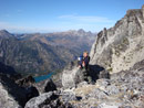
No. It appears that OP went up The Chasm. The route Randy and I descended was N of that. If ascending that route, start near the bottom of The Chasm, then work NW to a basin (c. 4400'), then S to the rib just N of The Chasm, then follow the rib W then WNW towards the saddle above Pea Soup. From the saddle, it's an easy contour/traverse over to the Daniel Glacier.
ETA: The Chasm has been ascended to the Daniel Glacier and then skied in earlier season conditions.
|
| Back to top |
|
|
GaliWalker
Have camera will use
Joined: 10 Dec 2007
Posts: 4929 | TRs | Pics
Location: Pittsburgh |
|
GaliWalker
Have camera will use
|
Mon Apr 18, 2016 12:34 pm |
|
|
BigSteve, I've been up that route to Pea Soup lake and some of the OP's photos look awfully like mine. Here is why I think he went up that route, and not up the chasm:
| christensent wrote: | | I made a very poor decision to start up a narrow couloir hoping it'd come out at the base of the Daniel Glacier since I didn't know how people usually get up here. It turns out it actually just had a big crack full-width and was impassable. Skied back down 800 feet and found the correct route a little further up the valley |
|
| Back to top |
|
|
DIYSteve
seeking hygge
Joined: 06 Mar 2007
Posts: 12655 | TRs | Pics
Location: here now |
|
DIYSteve
seeking hygge
|
Mon Apr 18, 2016 12:54 pm |
|
|
|
| Back to top |
|
|
|
|


