| Previous :: Next Topic |
| Author |
Message |
Earthbound
Member


Joined: 25 Oct 2008
Posts: 16 | TRs | Pics
|
This one was a long time coming. When I walked the Continental Divide Trail (CDT) in 2005, I was fairly disappointed in the route through the Wind River Range in Wyoming. The Winds run from SE to NW for approximately 100 miles, with the Continental Divide cresting the range for its entire length, forming what may be the most remote mountain range located in the most sparsely populated state in the lower 48. The southwest shoulder of the Winds is characterized by a massive, broad alpine plateau that stands at around 10,000 ft. and is dominated by meadows and lakes. The CDT runs mostly through this plateau as it makes its way through the Winds very pretty country, but not the kind of rugged alpine terrain that one would expect for the CDT through these mountains. I remember walking the CDT through these parklands and looking north at the mountains, wishing the trail was routed there instead. I vowed to return some day and walk a route through the Winds that was more fitting for the CDT a route that stayed closer to the divide, or at least in the mountains.
In the 11 years since I walked through these mountains, many seem to have had the same idea as me. A number of people have published their own versions of the Wind River High Route Alan Dixon, Dan McCoy, Andrew Shurka, etc. Ive been refining my route off and on for the last year or so, looking at other peoples routes and combing through various guidebooks. I settled on a route that felt like it took in the best of the range: http://caltopo.com/m/7MF9 My friend Joel Podgorski, who I knew from my days living in Boulder, CO, flew in from Switzerland and we met in Lander, WY on August 3rd, 2016. The first thing we did was to set up the car shuttle, leaving one car at the Glacier Trailhead (AKA Trail Lake Ranch). We spent the night comfortably camping in the Lander City Park, where free camping is allowed. The following morning, we drove the second car up to Worthen Meadows Trailhead for the start of our hike on the Stough Creek Basin Trail.
All in all, the trip was a great success. We completed 85% of my route, only being forced off the final high divide traverse due to bad weather.
Day 1: We trudged up the trail out of Worthen Meadows burdened with 10 days worth of food on the Stough Creek Basin Trail. 10 days of food, we thought, would allow ample time to complete the route, while allowing for a few side trips and potential days spent in our tents due to bad weather. This all sounded good on paper, but the reality of a 10 day pack was a bit harsh once on our backs. Travel was slow. Day 1 was dominated by occasional views of Wind River Peak the southernmost 13er in the range, and our objective as our first side trip.
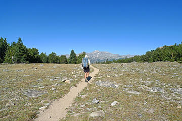 First View of Wind River Peak 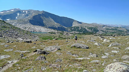 Ice Lakes Basin 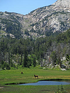 Elk at a small Tarn on Ice Lakes Trail 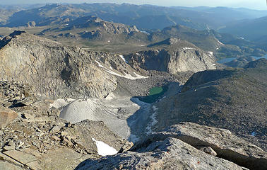 Wind River Peak Glacier 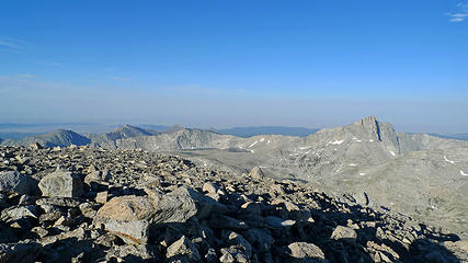 Temple Peak and Frozen Lakes 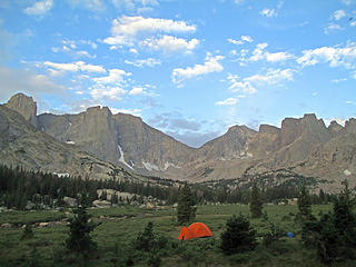 Cirque of the Towers 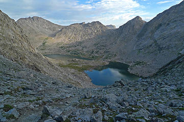 Texas and Barren Lakes from Texas Pass 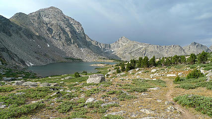 Billy's Lake 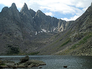 Shadow Lake 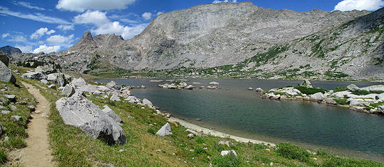 Pyramid Lake 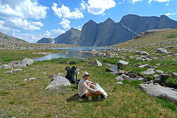 Joel at unnamed Lake in upper East Fork Drainage 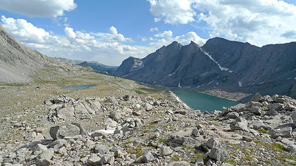 Upper East Fork Drainage 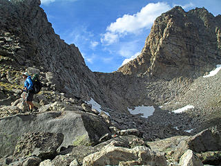 Raid Peak Pass 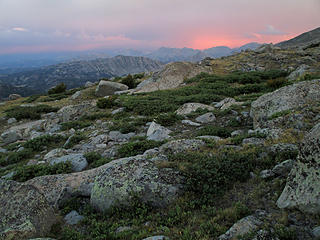 Ominous clouds from camp 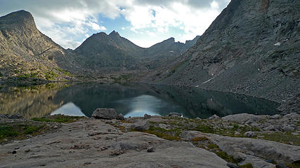 Bonneville Lake 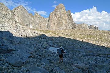 Bonneville Lake Pass 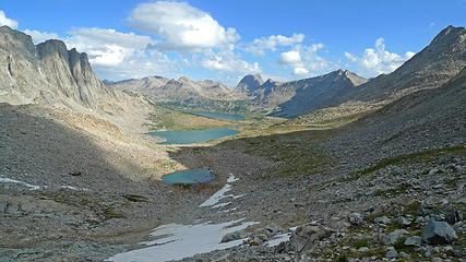 Middle Fork Dranage 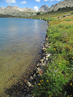 Shores of Lee Lake 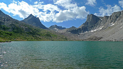 Lee Lake Lunch Spot 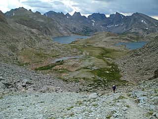 Approaching Photographic Pass 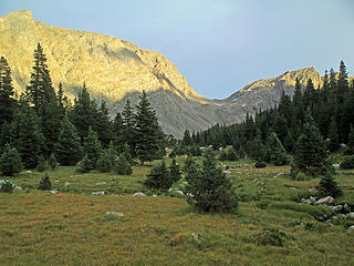 Photographic Pass from near our camp 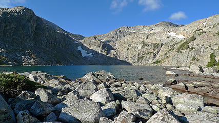 Lake 10,563 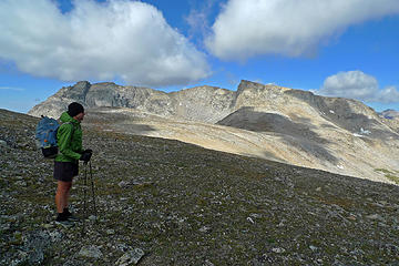 Europe Peak 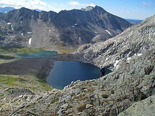 Europe Canyon 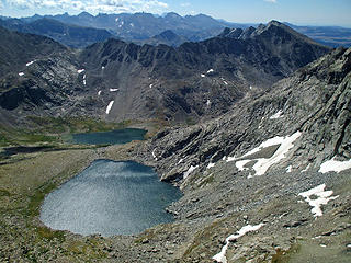 Looking SE from Europe Peak 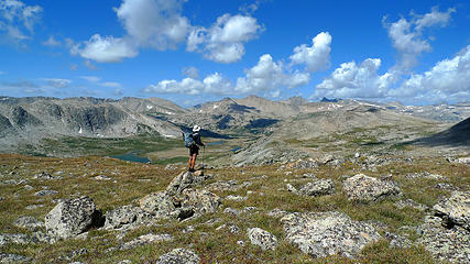 Joel on the Divide 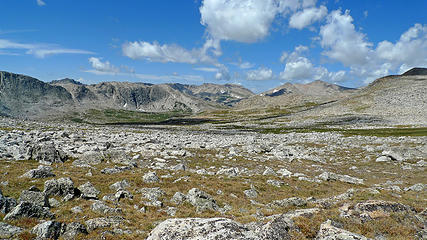 Alaska-like Continental Divide 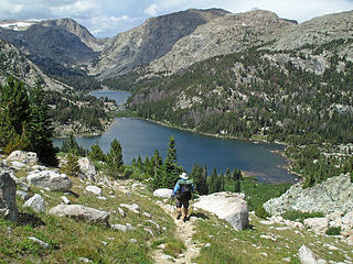 . 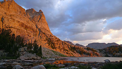 Morning at Camp Lake 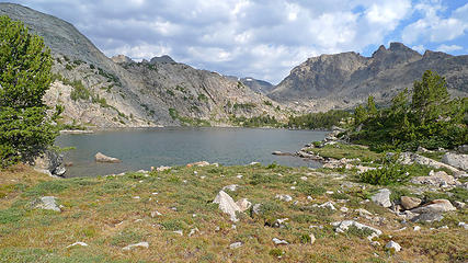 Talus Lake 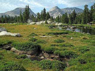 Parklands at the head of Bull Lake Creek 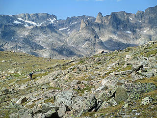 Goat Friendly High Route View 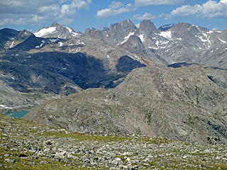 Goat Friendly High Route View 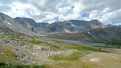 Descending into Shangra La 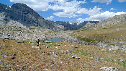 Shangra La Lakes 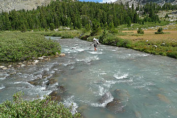 Crossing Knifepoint Creek 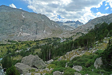 Knifepoint Creek and Glacier 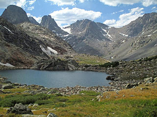 Tarn above North Fork Bull Lake Creek 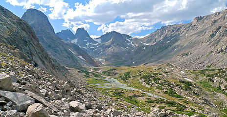 Upper Reaches of North Fork Bull Lake Creek 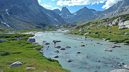 Crossing North Fork of Bull Lake Creek 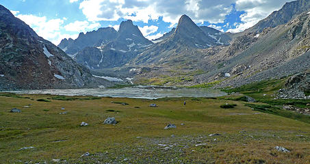 Helen Glacier Outflow 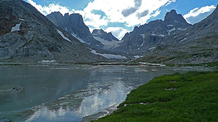 Helen Glacier Outflow 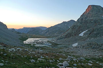 Sunrise from just above our camp 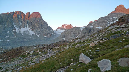 Morning Light as we begin climb to Blaurock Pass 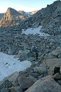 Blaurock Boulder 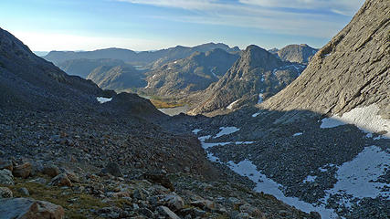 From whence we had come,
from near top of Blaurock Pass 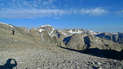 Gannet Peak from Blaurock Pass 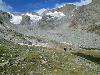 Gannet Peak on Descent from Blaurock Pass 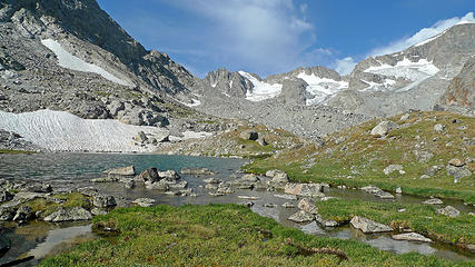 Elk Lake 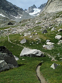 Glacier Trail 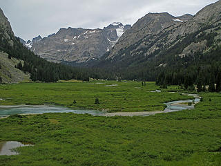 Gannet Peak from Floyd Wilson Meadows 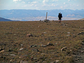 Cresting out on Goat Flat on the trail out
|
| Back to top |
  
|
|
awilsondc
Member

Joined: 03 Apr 2016
Posts: 1324 | TRs | Pics
|
|
| Back to top |
|
|
RichP
Member

Joined: 13 Jul 2006
Posts: 5634 | TRs | Pics
Location: here |
|
RichP
Member
|
 Sat Sep 03, 2016 5:04 pm |
|
|
Bravo! Superb report on a special part of the world.
|
| Back to top |
|
|
Distel32
Member
Joined: 03 Jun 2014
Posts: 961 | TRs | Pics
Location: Edmonds, WA |
|
Distel32
Member
|
Sat Sep 03, 2016 5:41 pm |
|
|
 currently our number one choice for our fall trip. Thanks for posting. currently our number one choice for our fall trip. Thanks for posting.
|
| Back to top |
|
|
MLHSN
What goes here?????

Joined: 09 Sep 2007
Posts: 1069 | TRs | Pics
Location: Wenatchee |
|
MLHSN
What goes here?????
|
Sat Sep 03, 2016 8:11 pm |
|
|
Thanks for the report! Always wanted to visit the Wind River Range.
|
| Back to top |
|
|
Cascade Dan
Member

Joined: 24 Sep 2003
Posts: 35 | TRs | Pics
Location: Seattle, WA |
Nice report, we have hiked all of those routes over the 20 years except for Stough Creek Drainage. You did quite well, some tough sections, esp Blaurock.
|
| Back to top |
|
|
cefire
Member

Joined: 03 Feb 2010
Posts: 523 | TRs | Pics
|
|
cefire
Member
|
Sun Sep 04, 2016 8:31 pm |
|
|
|
| Back to top |
|
|
Jim Dockery
Member

Joined: 12 Sep 2007
Posts: 3092 | TRs | Pics
Location: Lake Stevens |
Most excellent!
|
| Back to top |
|
|
Snowdog
Member

Joined: 21 Jul 2006
Posts: 1028 | TRs | Pics
Location: on (& off) the beaten path |
|
Snowdog
Member
|
Mon Sep 05, 2016 1:00 pm |
|
|
Really nice TR! I've been reading some blogs of other trips in the Winds- yours did not disappoint!
'we don't have time for a shortcut'
'we don't have time for a shortcut'
|
| Back to top |
|
|
Bedivere
Why Do Witches Burn?

Joined: 25 Jul 2008
Posts: 7464 | TRs | Pics
Location: The Hermitage |
|
Bedivere
Why Do Witches Burn?
|
Mon Sep 05, 2016 2:09 pm |
|
|
Thanks much for this thorough and most excellent report!
I'm planning to head there for a week in '18 and this is great beta.
|
| Back to top |
|
|
Stefan
Member

Joined: 17 Dec 2001
Posts: 5093 | TRs | Pics
|
|
Stefan
Member
|
Mon Sep 05, 2016 2:32 pm |
|
|
I totally agree with you. The Winds are most fabulous at the lake level looking at the mountains!
|
| Back to top |
|
|
Anish
Member
Joined: 07 Sep 2014
Posts: 79 | TRs | Pics
|
|
Anish
Member
|
Mon Sep 05, 2016 2:50 pm |
|
|
Great report Doug! Makes me miss that area very much. Sounds like an incredibly scenic and challenging trip. Definitely on my list.
"Our way is not soft grass. It's a mountain path with lots of rocks. But it goes upwards, forward, toward the sun." -Ruth Westheimer
"Our way is not soft grass. It's a mountain path with lots of rocks. But it goes upwards, forward, toward the sun." -Ruth Westheimer
|
| Back to top |
|
|
Magellan
Brutally Handsome

Joined: 26 Jul 2006
Posts: 13116 | TRs | Pics
Location: Inexorable descent |
|
Magellan
Brutally Handsome
|
Mon Sep 05, 2016 3:38 pm |
|
|
Trip report of the year! Thanks for taking the time to write it up.
|
| Back to top |
|
|
Jaberwock
Member
Joined: 30 Jan 2013
Posts: 722 | TRs | Pics
Location: Bellingham |
WHoa!!! I'm headed there next week!
|
| Back to top |
|
|
Earthbound
Member
Joined: 25 Oct 2008
Posts: 16 | TRs | Pics
|
Thanks for the kind words everyone. It was an amazing trip. Needless to say, I'm going back next year to explore that northern section we missed, and climb Gannet. 
|
| Back to top |
|
|
|
|
You cannot post new topics in this forum
You cannot reply to topics in this forum
You cannot edit your posts in this forum
You cannot delete your posts in this forum
You cannot vote in polls in this forum
|
Disclosure: As an Amazon Associate NWHikers.net earns from qualifying purchases when you use our link(s). |


