| Previous :: Next Topic |
| Author |
Message |
Trailcat
Member


Joined: 12 Mar 2016
Posts: 28 | TRs | Pics
|
|
Trailcat
Member
|
 Sun Sep 11, 2016 8:28 pm |
|
|
High Chiwaukum Traverse September 2-6, 2016
Big McWaukum Peak
Big Chiwaukum Peak
Ladies Peak
Unsettled weather over Labor Day Weekend sent many of us scrambling for alternative trips. Eileen and I ended up doing a high alpine traverse through the Chiwuakum Mountains, hoping for better conditions. We have both spent several decades exploring the many nooks and crannies of the Chiwuakums, and this traverse served as a way to connect some of our favorite locations, such as Larch Lake, Grace Lakes, Ewing Basin, and the High Meadows of the Scottish Lakes. It also gave us access to the five principal summits of the Chiwaukum crest: Big McWaukum Peak (7423), Deadhorse Peak (7534), Big Chiwaukum Peak (8081), Snowgrass Mountain (7993), and Ladies Peak (7708). Along the way, we were able to tuck in the three peaks that we hadnt both climbed before.
Day 1: Trailhead to Lake Ethel
Our trip started by stashing mountain bikes at the Whitepine Creek TH, then driving over to the Lake Ethel TH. We headed up the well-maintained trail in the late afternoon. It was cool, windy, and a bit rainy during our 5-mile hike to Lake Ethel. We found a spacious and spotlessly clean campsite nestled in deep forest near the lake shore.
Day 2: Lake Ethel to Larch Lake
Our second day began with partly clear skies and morning sun on the lake. This gave us some hope that the weather was improving, but it turned out to be a false hope.
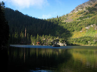 21.LakeEthel 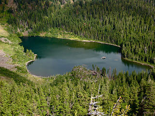 21.LakeEthelFromEthelEileenSaddle 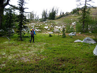 21.WalkingThruHighMeadow 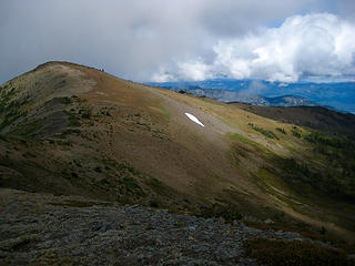 21.MtBaldyFromMcWaukumPass 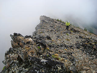 21.HeadingUpBigMcWaukumPeak 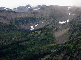 21.LarchLake&CupLakeFromMcWaukumPass 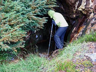 21.EileenAtEwingMine 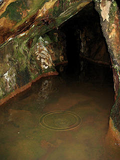 21.EwingMineShaft 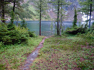 21.LarchLake 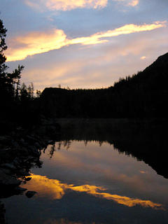 21.MorningSunOnLarchLake 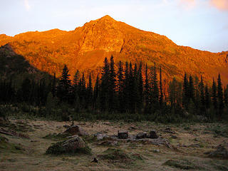 21.AlpenglowOnDeadhorsePeak 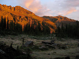 21.AlpenglowOnBigMcWaukumPeak 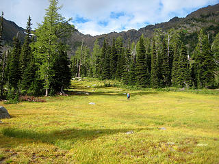 21.HeadingForCupLake 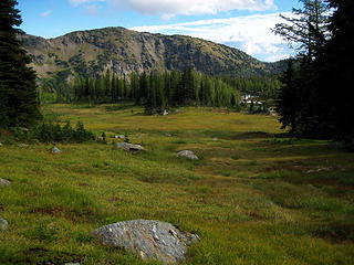 21.LarchLakeMeadow 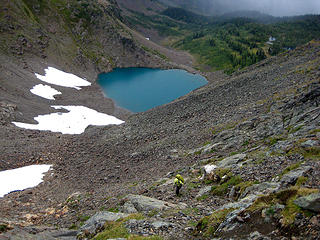 21.ClimbingAboveCupLake 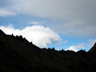 21.GendarmesAtDeadhorsePass 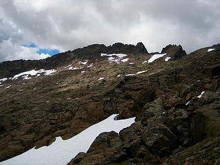 21.BigChiwaukumPeakFromCupLakeSaddle 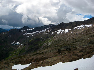 21.LadiesPeak&SnowgrassMtnFromCupLkSaddle 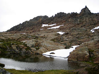 21.BigChiwaukumPeakAboveTarn 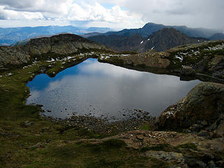 21.TarnBelowBigChiwaukumPeak 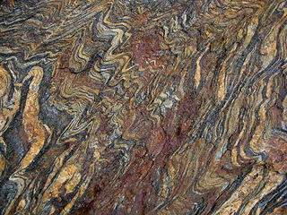 21.ChiwaukumSchistTexture 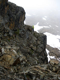 21.BelayingAcrossExposedLedge 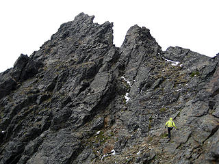 21.ScramblingToBigChiwaukumSummit 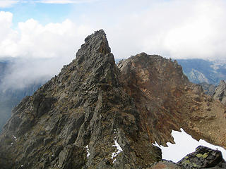 21.BigChiwaukumSummitPinnacle 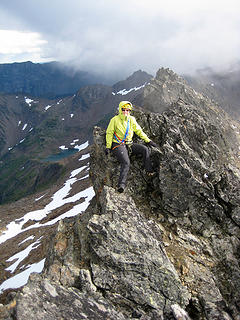 21.EileenOnBigChiwaukumPeak 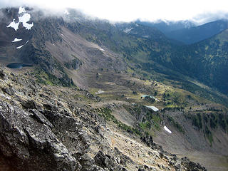 21.GraceLakesFromBigChiwaukumPeak 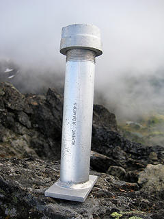 21.BigChiwaukumPkSummitRegister 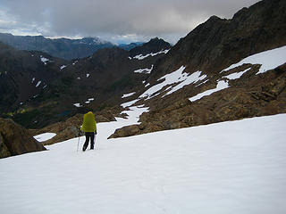 21.SnowRampBelowBigChiwaukumPeak 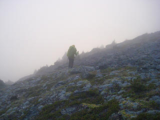 21.DuskDescentFromSnowaukumPass 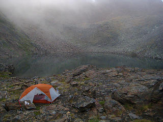 21.CampAtUpperGraceLake 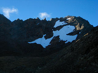 21.SnowgrassMtnFromUpperGraceLake 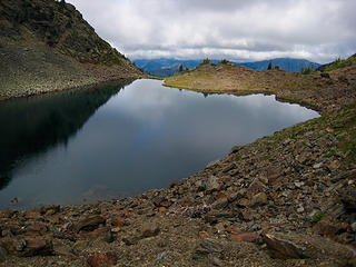 21.UpperGraceLake 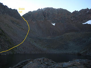 21.AscentRouteToGraceCol 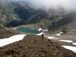 21.TraversingAboveLakeCharles  21.CrossingOverLakeCharlesPass 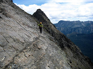 21.LedgeAtLakeCharlesPass 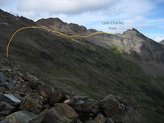 21.DescentRouteFromLakeCharlesPass 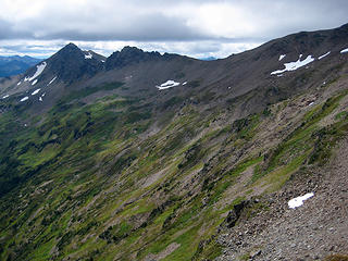 21.LadiesPeakFromLakeCharlesPass 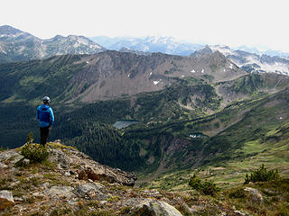 21.LakeFlora&LakeBrigham 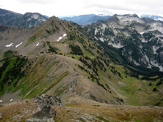 21.LadiesPassFromLadiesPeak 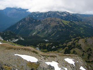 21.LkMargaret&LkMaryFromLadiesPeak 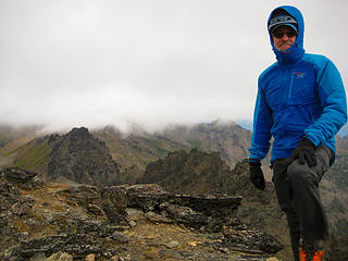 21.WindySummitOfLadiesPeak 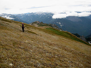 21.DescendingLadiesPeak 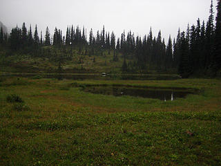 21.LakeMary 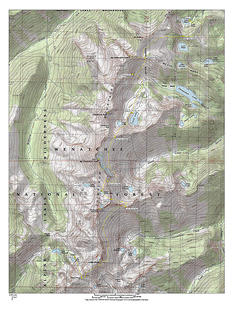 21.HighChiwaukumTraverseMap
|
| Back to top |
  
|
|
Gimpilator
infinity/21M

Joined: 12 Oct 2006
Posts: 1684 | TRs | Pics
Location: Edmonds, WA |
Very cool traverse! The peak you refer to as Big McWaukum Peak is more commonly known as Middle Chiwaukum, but not officially named, so call it whatever you like. 
|
| Back to top |
|
|
Distel32
Member

Joined: 03 Jun 2014
Posts: 961 | TRs | Pics
Location: Edmonds, WA |
|
Distel32
Member
|
Sun Sep 11, 2016 8:55 pm |
|
|
R3H and I were looking at the slabs on the east of Big C and thinking they would be fun to traverse. Thanks for confirming that.
|
| Back to top |
|
|
Brushbuffalo
Member

Joined: 17 Sep 2015
Posts: 1887 | TRs | Pics
Location: there earlier, here now, somewhere later... Bellingham in between |
| Trailcat wrote: | The Chiwaukum schist here exhibits incredibly artistic textures, with convoluted bands of colorful minerals.
21.ChiwaukumSchistTexture |
That's gorgeous, particularly to a geologist! My eyes are practically stuck to my tablet screen.

Passing rocks and trees like they were standing still
Passing rocks and trees like they were standing still
|
| Back to top |
|
|
Kenji
Member
Joined: 18 May 2010
Posts: 320 | TRs | Pics
Location: Seattle |
|
Kenji
Member
|
Mon Sep 12, 2016 9:47 pm |
|
|
Quite a trip!!
|
| Back to top |
|
|
GaliWalker
Have camera will use

Joined: 10 Dec 2007
Posts: 4931 | TRs | Pics
Location: Pittsburgh |
|
GaliWalker
Have camera will use
|
Tue Sep 13, 2016 6:33 am |
|
|
Wow! What a cool trip.
|
| Back to top |
|
|
Randito
Snarky Member

Joined: 27 Jul 2008
Posts: 9513 | TRs | Pics
Location: Bellevue at the moment. |
|
Randito
Snarky Member
|
Tue Sep 13, 2016 6:41 am |
|
|
Nice!
|
| Back to top |
|
|
Ringangleclaw
Member
Joined: 01 Sep 2010
Posts: 1559 | TRs | Pics
|
That would make a killer bong
|
| Back to top |
|
|
ChinookPass
Member

Joined: 21 Aug 2009
Posts: 145 | TRs | Pics
|
Great trip! Thanks for posting.
|
| Back to top |
|
|
wildernessed
viewbagger

Joined: 31 Oct 2004
Posts: 9275 | TRs | Pics
Location: Wenatchee |
Living in the Anthropocene
Living in the Anthropocene
|
| Back to top |
|
|
Magellan
Brutally Handsome

Joined: 26 Jul 2006
Posts: 13117 | TRs | Pics
Location: Inexorable descent |
|
Magellan
Brutally Handsome
|
Wed Sep 14, 2016 12:27 pm |
|
|
Thanks for taking the time to write it up. I have not seem one of the roamers tubes before.
|
| Back to top |
|
|
Taxx
Member
|
|
Taxx
Member
|
Wed Sep 14, 2016 12:50 pm |
|
|
|
| Back to top |
|
|
ree
Member

Joined: 29 Jun 2004
Posts: 4399 | TRs | Pics
|
|
ree
Member
|
Wed Sep 14, 2016 12:58 pm |
|
|
|
| Back to top |
|
|
Kim Brown
Member
Joined: 13 Jul 2009
Posts: 6900 | TRs | Pics
|
Nice to see a trailcat report again.
Agree with the Buffalo; beautiful rock.
"..living on the east side of the Sierra world be ideal - except for harsher winters and the chance of apocalyptic fires burning the whole area."
Bosterson, NWHiker's marketing expert
"..living on the east side of the Sierra world be ideal - except for harsher winters and the chance of apocalyptic fires burning the whole area."
Bosterson, NWHiker's marketing expert
|
| Back to top |
|
|
Trailcat
Member
Joined: 12 Mar 2016
Posts: 28 | TRs | Pics
|
|
Trailcat
Member
|
Wed Sep 14, 2016 9:19 pm |
|
|
I received an email from James Aga, one the the most intrepid explorers of the Scottish Lakes region. He is in the small group of people who have probed into Ewing Mine, and he supplies these interesting details about the mine:
"The gold mine ends in about 50-60 feet. I didn't have high boots but, you know, curiosity drowned the cat. A flash picture at the end shows lots of sparkly rock(quartz maybe?). In the 70's, some horse packers who were camped in Ewing Basin invited me in for coffee (it was pouring), and they told me about the mine, which I'd never noticed in spite of many visits to Ewing Basin. They said that "as soon as you get far enough in to lose the light, the shaft goes straight down" (that was wrong). They also told me it was originally mined in the 1890's and re worked during the 1930's. They also said that the miners packed in from the Ellensburg side over Deadhorse pass from the West. They also said there was a cabin around Larch Lake which we (Eileen and I) searched for any such remnants but found none.
I've never been able to find any historical or mining records or who/how Deadhorse Pass got named and put on every usgs map. The miner's story about packing in from that side seems plausible given the horrible trail that goes up Chiwaukum Creek and given that, although the pass isn't horrible, one can easily imagine a pack horse tripping and leaving a skeleton behind for many years."
|
| Back to top |
|
|
|
|
You cannot post new topics in this forum
You cannot reply to topics in this forum
You cannot edit your posts in this forum
You cannot delete your posts in this forum
You cannot vote in polls in this forum
|
Disclosure: As an Amazon Associate NWHikers.net earns from qualifying purchases when you use our link(s). |


