| Previous :: Next Topic |
| Author |
Message |
Brushbuffalo
Member


Joined: 17 Sep 2015
Posts: 1887 | TRs | Pics
Location: there earlier, here now, somewhere later... Bellingham in between |
Here are a few pictures captured on my "field check" on the Ridley Creek and Park Butte trails, hiked on September 26. Be sure to check out jdk610's blog for some beautiful pictures from her fine run of all of the major trails there, also done on Sept. 26th.
More detail will be available in book form when Dave Tucker releases his new book on geology of the Mount Baker area. Watch for it!
Middle Fork of the Nooksack. Virtually all of the surface sediment here was deposited by a debris flow on May 31, 2013. Much more detail here.
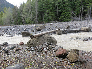 Bridge rests on debris deposited in the 2013 debris flow 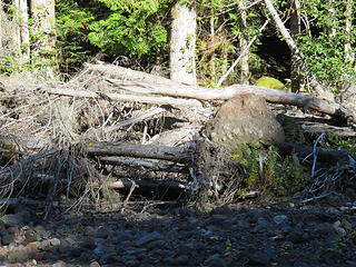 Trees knocked over by the 2013 debris flow 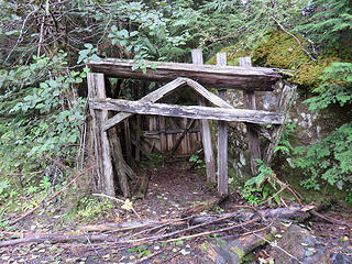 Rumor is that this was built to shelter judges during the 1911-13 Mt. Baker marathons. Not likely, as such a shelter would have been wiped out in the large 1927 glacier outburst flood from the Deming Glacier. 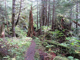 Poor picture of house-size boulders, now looming in the forest, carried by the Deming Glacier in the latest Pleistocene (deposited about 12,600 years ago) 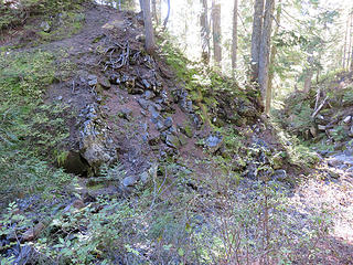 Only lava flow crossed by Ridley Creek trail. 43,000 yrs. old (old for Mt. Baker itself but relatively young in the Mount Baker Volcanic Field) 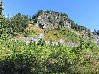 Trail from Mazama Park to Cathedral Pass (on right) switchbacks below Cathedral Crag, a single thick basaltic andesite flow some 330,000 years old. A flow of this composition that thick would have been due to ponded lava. Trail is barely visible in this view, but it is good! 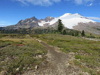 Mount Baker and the older remnants of the Black Buttes volcano (note the strata).Colfax Peak (center) and Lincoln Peak (left). View from Tarn Plateau 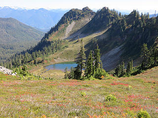 Survey Point (non-volcanic) and Pocket Lake, a classic small tarn. Looking east from Tarn Plateau, 200,000 year old andesite (I coined 'Tarn Plateau' in my MS thesis, and it has stuck in the geologic literature  ) 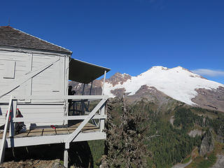 My favorite lookout 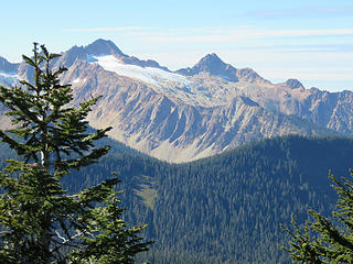 North and South (left) Sisters, a large slice of the mantle. Composed of olivine-rich dunite and peridotite. Its glaciers are barely surviving. ![Receding Easton (center) and Squak Glaciers(right) from Park Butte. [url=https://mbvrc.wordpress.com/baker-facts/1912-2012-historic-photos-document-100-years-of-changes-at-mount-baker/]compare 1912[/url]. Portions of Deming (far left) and Talum (far right) also show. From Park Butte.](https://cloud.nwhikers.net/29453592374_320x240.jpg) Receding Easton (center) and Squak Glaciers(right) from Park Butte. compare 1912. Portions of Deming (far left) and Talum (far right) also show. From Park Butte. 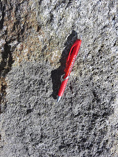 Pre-Mt. Baker basalt, rare in the Mt. Baker volcanic field. Contains green olivine crystals. I had the good fortune to first document this rock in 1976 near Park Butte, but it is much older than I had assumed (about 716,000 years old!), among the oldest lavas to be erupted outside of the Kulshan caldera, and the oldest you will find along a trail in the MBVF. 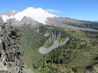 Note the trail in lower center connecting Mazama Park to Cathedral Pass. The trail from Mazama Park to Baker Pass is north of this (closer to Mt. Baker)
Passing rocks and trees like they were standing still
Passing rocks and trees like they were standing still
|
| Back to top |
  
|
|
mbravenboer
Member

Joined: 20 Oct 2013
Posts: 1422 | TRs | Pics
Location: Seattle |
Very interesting! I love that post about the debris flow.
|
| Back to top |
|
|
Sculpin
Member

Joined: 23 Apr 2015
Posts: 1383 | TRs | Pics
|
|
Sculpin
Member
|
 Mon Oct 03, 2016 12:54 pm |
|
|
| Brushbuffalo wrote: | | North and South (left) Sisters, a large slice of the mantle. Composed of olivine-rich dunite and peridotite. |
Just read a couple posts on the Elbow Lake route that accesses Sister Divide, so I will be heading up there next season. I'm interested in plant edaphic specialization on ultramafics, so have been looking for a good route up there even though I have heard there is not much of that on the Sisters. Wondering if you know: is this exposure of mantle rock part of an ophiolitic sequence or did it get emplaced some other way?
Between every two pines is a doorway to the new world. - John Muir
Between every two pines is a doorway to the new world. - John Muir
|
| Back to top |
|
|
puzzlr
Mid Fork Rocks

Joined: 13 Feb 2007
Posts: 7220 | TRs | Pics
Location: Stuck in the middle |
|
puzzlr
Mid Fork Rocks
|
Mon Oct 03, 2016 1:12 pm |
|
|
Thanks for telling us what you see when you look at these landscapes. It's very interesting.
|
| Back to top |
|
|
Brushbuffalo
Member
Joined: 17 Sep 2015
Posts: 1887 | TRs | Pics
Location: there earlier, here now, somewhere later... Bellingham in between |
| Sculpin wrote: | | this exposure of mantle rock part of an ophiolitic sequence or did it get emplaced some other way? |
Good question!
The Twin Sisters Range as viewed from Park Butte just might be the finest view anywhere on Earth of a large chunk of the mantle. The Twin Sisters rock was formed 5 to 10 miles below the crust, probably proto-Pacific Ocean far from North America's present location. The huge slab was somehow incorporated into the Bell Pass Melange when tectonic plates collided and was subducted along with the associated ocean crust, then was thrust upward along high-angle faults and exposed by erosion.
That's the short answer. Sorry, don't have the energy to give the long answer, being retired and all!  I don't believe it is considered to be part of an ophiolitic complex such as we can see at Fidalgo and Cypress Islands, at least not a classic ophiolite with ultramafics, gabbro, pillow basalts, chert, and mudstone.
Phew!
For more details, I recommend Geology of the North Cascades by Tabor and Haugerud.
I don't believe it is considered to be part of an ophiolitic complex such as we can see at Fidalgo and Cypress Islands, at least not a classic ophiolite with ultramafics, gabbro, pillow basalts, chert, and mudstone.
Phew!
For more details, I recommend Geology of the North Cascades by Tabor and Haugerud.
Passing rocks and trees like they were standing still
Passing rocks and trees like they were standing still
|
| Back to top |
|
|
contour5
Member

Joined: 16 Jul 2003
Posts: 2963 | TRs | Pics
|
|
contour5
Member
|
Mon Oct 03, 2016 8:46 pm |
|
|
Excellent post! Very much appreciate your taking the time to put this one together.
|
| Back to top |
|
|
Brushbuffalo
Member
Joined: 17 Sep 2015
Posts: 1887 | TRs | Pics
Location: there earlier, here now, somewhere later... Bellingham in between |
| contour5 wrote: | | Excellent post! Very much appreciate your taking the time to put this one together. |
Thanks. I hope my sometimes-unconventional approach to trip reports is helpful and not annoying with too much information. Of course like any other TR, a person can read 'em or not! 
Passing rocks and trees like they were standing still
Passing rocks and trees like they were standing still
|
| Back to top |
|
|
Pyrites
Member
Joined: 16 Sep 2014
Posts: 1884 | TRs | Pics
Location: South Sound |
|
Pyrites
Member
|
Mon Oct 03, 2016 9:35 pm |
|
|
Are you kidding? Class A report. Better than "I went somewhere. It rained."
Keep Calm and Carry On?
Heck No.
Stay Excited and Get Outside!
Keep Calm and Carry On?
Heck No.
Stay Excited and Get Outside!
|
| Back to top |
|
|
HitTheTrail
Member

Joined: 30 Oct 2007
Posts: 5460 | TRs | Pics
Location: 509 |
Great post. Rather unique but very informative in a specialized sort of way.  Keep it up for other areas of geologic interest.
This is a bit off topic, but do any of you guys (or gals) know anything about the specific lithology of the Jurassic Ingalls Terrane (Jis on geologic maps). It looks to me to weather sort of like limestone and looks like a calcareous sandstone or sandy limestone. When I google the term they describe it as nothing like that. They are saying it is ultramafic. Up around Lake Caroline and Mt. Cashmere it is light brown and grussy looking. In fact the slide that came down into Eight Mile Lake are from those rocks and they are light brown. I don't get it. Keep it up for other areas of geologic interest.
This is a bit off topic, but do any of you guys (or gals) know anything about the specific lithology of the Jurassic Ingalls Terrane (Jis on geologic maps). It looks to me to weather sort of like limestone and looks like a calcareous sandstone or sandy limestone. When I google the term they describe it as nothing like that. They are saying it is ultramafic. Up around Lake Caroline and Mt. Cashmere it is light brown and grussy looking. In fact the slide that came down into Eight Mile Lake are from those rocks and they are light brown. I don't get it.
|
| Back to top |
|
|
Anish
Member
Joined: 07 Sep 2014
Posts: 79 | TRs | Pics
|
|
Anish
Member
|
Tue Oct 04, 2016 3:54 pm |
|
|
Great stuff! Park Butte is also my favorite lookout. Thanks for all the information.
"Our way is not soft grass. It's a mountain path with lots of rocks. But it goes upwards, forward, toward the sun." -Ruth Westheimer
"Our way is not soft grass. It's a mountain path with lots of rocks. But it goes upwards, forward, toward the sun." -Ruth Westheimer
|
| Back to top |
|
|
Brushbuffalo
Member
Joined: 17 Sep 2015
Posts: 1887 | TRs | Pics
Location: there earlier, here now, somewhere later... Bellingham in between |
HitTheTrail, I recall those brown rocks when descending on the trail after climbing Cashmere last year. They appeared to be ultramafic such as we see at the Twin Sisters and Ingalls Peak, as well as other more isolated places. Even though the rocks when freshly exposed are various tones of green, they weather to a rust color when oxidized. If peridotite rather than dunite (which is 90% or more olivine and usually Mg-rich green olivine), then pyroxene varieties such as enstatite and diopside are more abundant, giving the peridotite a brownish or grayish color even before oxidizing.
I haven't answered your specific question about the Ingalls terrane, however. [ note, gentle readers, that is not a misspelling of terrain, as in landforms. "Terrane" refers to an assemblage of rocks of vastly different place of origin than where found today. This is plate tectonics in action].
Passing rocks and trees like they were standing still
Passing rocks and trees like they were standing still
|
| Back to top |
|
|
HitTheTrail
Member
Joined: 30 Oct 2007
Posts: 5460 | TRs | Pics
Location: 509 |
Yeah, if the official geologic map says so and you say so they must be ultramafic. I was just thrown off by the color and the fact that they weather similar to the way some calcareous rocks weather. Guess I needed to look at them in thin section under a petscope. Thanks.
|
| Back to top |
|
|
Brockton
Member
Joined: 02 Aug 2012
Posts: 266 | TRs | Pics
Location: West Seattle |
|
Brockton
Member
|
Tue Oct 04, 2016 8:58 pm |
|
|
Brushbuffalo - That was great, thanks. I'm always interested to learn more about local geology. Even if I don't understand everything, it's fun to read your geological notes along with the stunning photos. I'd love to see more reports like that. Thanks!
|
| Back to top |
|
|
Sculpin
Member
Joined: 23 Apr 2015
Posts: 1383 | TRs | Pics
|
|
Sculpin
Member
|
Wed Oct 05, 2016 7:49 am |
|
|
| Brushbuffalo wrote: | | I don't believe it is considered to be part of an ophiolitic complex such as we can see at Fidalgo and Cypress Islands, at least not a classic ophiolite with ultramafics, gabbro, pillow basalts, chert, and mudstone. |
Thanks for taking the time to respond. I will report back next season whether I find any of this stuff, assuming I find a way across the river.
Me, I'm going to suck up any geology info that gets posted!
Between every two pines is a doorway to the new world. - John Muir
Between every two pines is a doorway to the new world. - John Muir
|
| Back to top |
|
|
Brushbuffalo
Member
Joined: 17 Sep 2015
Posts: 1887 | TRs | Pics
Location: there earlier, here now, somewhere later... Bellingham in between |
| Sculpin wrote: | | I will report back next season whether I find any of this stuff, assuming I find a way across the river. |
That little log bridge is the key to a safe river crossing. How long it will last is unknowable, but it's been two years so far.
Passing rocks and trees like they were standing still
Passing rocks and trees like they were standing still
|
| Back to top |
|
|
|
|


![Receding Easton (center) and Squak Glaciers(right) from Park Butte. [url=https://mbvrc.wordpress.com/baker-facts/1912-2012-historic-photos-document-100-years-of-changes-at-mount-baker/]compare 1912[/url]. Portions of Deming (far left) and Talum (far right) also show. From Park Butte.](https://cloud.nwhikers.net/29453592374_04e1da3509_h.jpg#1600x1200+https://farm9.staticflickr.com/8655/29453592374_d4fdaa572e_o.jpg#2048x1536+144d098abd_k.jpg#2048x1536+04e1da3509_h.jpg#1600x1200+805f338f07_b.jpg#1024x768)

