| Previous :: Next Topic |
| Author |
Message |
whitebark
Member


Joined: 08 Jul 2005
Posts: 1864 | TRs | Pics
Location: Seattle |
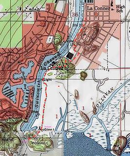
My usual Sunday hiking buddies were not particularly ambitious on this grey, rainy day, so we decided to resurrect an old Footsore guidebook hike (Footsore 3 first edition page 129, starting in La Conner. After parking at the north end of La Conner's cute downtown, near the Nasty Jacks antique store, we walked south down the main street. It was pretty sleepy in La Conner and many of the shops were closed. But the Calico Cupboard bakery was open at the south end, and if the weather got too nasty we could always bail out and and get something to eat there. As it was only drizzling, we continued south on various streets to Pioneer Park near the Swinomish channel bridge. Short but nice trails led us up and over the forested headland, under the bridge, through a collection of picnic shelters, and back down to the waterfront.
The paved road heading along the Swinomish Channel soon ended at a gate signed "No Trespassing, entry by permission only". But locals seemed to ignore this sign completely and have for years, so we walked around the gate and continued south on the waterfront road which was surround by fields and marshes, pleasantly rural. In a half mile, the road reached a boat yard with an incredible collection of derelict vessels lying about everywhere, rotting away in the rain. I should have taken some pictures of this strangely picturesque place.
We walked past the boatyard and finally reached the rocky upland of McGlinn Island, which is an island only in name, as it is connected by land to La Conner. McGlinn is a real land ownership oddity - it is the property of the US Forest Service! I have no idea how that happened. The boat yard road eventually turned into a well used hiking trail which crossed over the saddle on the island and ended at a small picturesque beach next to the entrance of the Swinomish Channel.
While we were here, we heard quite a few amazingly loud gun blasts (shotguns?) coming from the marshes to the east. I think maybe there was a goose hunting season going on - it may be more tranquil here after Feb 1 when the goose season ends.
Side trails tempted us to explore more of the island, but the rain was increasing, so after a quick lunch we turned around and headed back to La Conner the way we came. To fight the cold rain we unleashed our ultimate weapon, a thermos full of "Gluhwein" (German hot spiced wine), which we sipped in one of the Pioneer Park picnic shelters. Suddenly the weather seemed a whole lot nicer after a cup of that! Back in La Conner, we stopped at the Calico Cupboard enjoyed some espresso drinks and pastries. Now that was more like it.
Hiking route:
 laconner
|
| Back to top |
  
|
|
PorcupinePhobia
Murse

Joined: 04 Mar 2012
Posts: 1002 | TRs | Pics
Location: Hwy20 |
funny to see my home town on a TR!  We refer to that area just as "Hole in the Wall" because you can walk the jetty(?) out to the fish way (hole in the jetty...) and then on to Goat Island.
A favorite high school drinking haunt. Good memories.
It seems the shooting over by Ika Island is always going on, no matter what time of year. There is a nice cabin over there that sees some helo traffic in the summer.
I wasn't aware the beach area was owned by the FS. I thought it was owned by the Chamberlyns.
We refer to that area just as "Hole in the Wall" because you can walk the jetty(?) out to the fish way (hole in the jetty...) and then on to Goat Island.
A favorite high school drinking haunt. Good memories.
It seems the shooting over by Ika Island is always going on, no matter what time of year. There is a nice cabin over there that sees some helo traffic in the summer.
I wasn't aware the beach area was owned by the FS. I thought it was owned by the Chamberlyns.
|
| Back to top |
|
|
Brushbuffalo
Member

Joined: 17 Sep 2015
Posts: 1887 | TRs | Pics
Location: there earlier, here now, somewhere later... Bellingham in between |
Thanks for posting on this gem of a town.
Did you notice the approximately 87,000 (😉) logs in the flat to the east of your path to the faux-island? They get deposited during " king tides" or flood events.
Yes, odd that USFS has land there. Anyone know the score there? Anatoli? Porcupine Phobia?
Passing rocks and trees like they were standing still
Passing rocks and trees like they were standing still
|
| Back to top |
|
|
whitebark
Member

Joined: 08 Jul 2005
Posts: 1864 | TRs | Pics
Location: Seattle |
| PorcupinePhobia wrote: | | We refer to that area just as "Hole in the Wall" because you can walk the jetty(?) out to the fish way (hole in the jetty...) and then on to Goat Island. |
So one can walk the jetty from McGlinn all the way to Goat Island? That would be fun! I'm guessing that this can be done only at low tide (to get past the hole in the wall).
|
| Back to top |
|
|
IanB
Vegetable Belayer

Joined: 21 Jul 2010
Posts: 1061 | TRs | Pics
Location: gone whuljin' |
|
IanB
Vegetable Belayer
|
 Tue Jan 10, 2017 11:27 pm |
|
|
Thanks for posting this.  Have always wanted to check this one out...
"Forget gaining a little knowledge about a lot and strive to learn a lot about a little." - Harvey Manning
"Forget gaining a little knowledge about a lot and strive to learn a lot about a little." - Harvey Manning
|
| Back to top |
|
|
PorcupinePhobia
Murse
Joined: 04 Mar 2012
Posts: 1002 | TRs | Pics
Location: Hwy20 |
Easier at low tide, the gap isn't much but still definitely getting wet if tide is above about 4 ft. The river running high seems to have an effect as well. Either way much more fun in the summer. It is common to have a logjam bridge tho.
There is decent camping at the flat on goat where the old pier was, and up at the very cool old Fort Whitney
|
| Back to top |
|
|
|
|


