| Previous :: Next Topic |
| Author |
Message |
Matt
Tea, Earl Grey, Hot


Joined: 30 Jan 2007
Posts: 4307 | TRs | Pics
Location: Shoreline |
|
Matt
Tea, Earl Grey, Hot
|
 Sun Mar 05, 2017 1:21 am |
|
|
Date: 2/11/2017
Destination: Burley Mtn (5403 feet, 903P) via Trout Creek Road and northwest ridge
Party: Matt, Yana, Dave Creeden
FYI, this is the Burley Mtn 5403 located north of Townsend Mtn in Snohomish County, not the Burley Mtn 5304 lookout in Lewis County.
For several years, Yana has been suggesting a winter trip to Burley, but I always balked at the long approach via Trout Creek. This winter, after months of minor peaks or repeats, I wanted to try a more challenging trip and agreed to it. We committed all day to trying it, but ended up falling short with a 16.5 hour round trip.
Short version: The Trout Creek road had some blowdown and washouts, but was in surprisingly good shape. Fording the north fork Trout Creek was steep and wet. Burley's west ridge ran well up to 4800 feet. The final ridge to the summit looked great in the distance. But the narrow section in between had too many impassable steep outcrops.
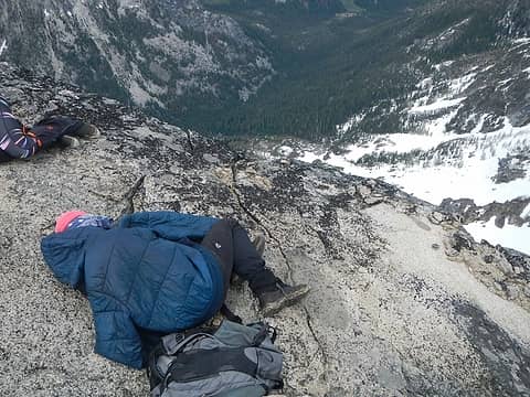
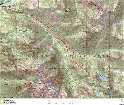 Burley GPS Track 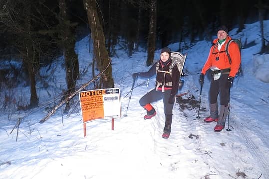 Start of the Trout Creek Road 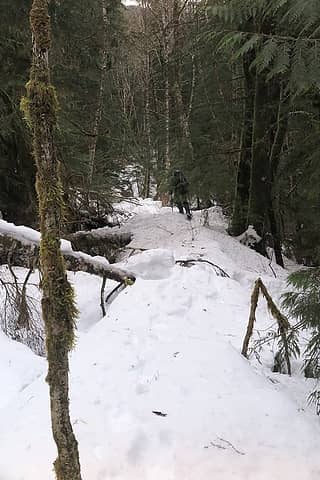 Dave hiking on the road 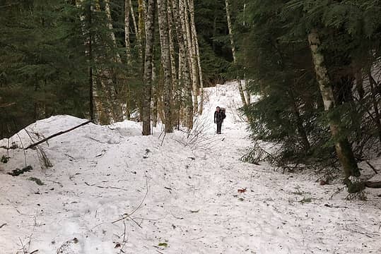 Yana hiking on the road 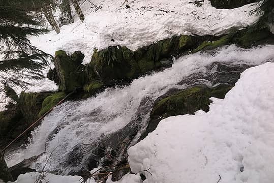 A steep creek crossing 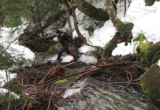 Yana crossing a side creek 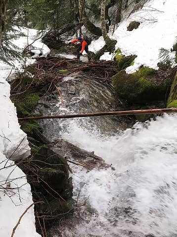 Dave crossing a side creek 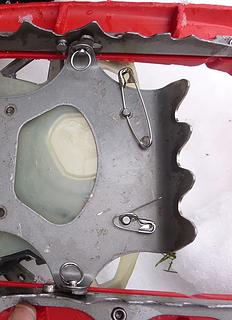 = Yana's photo of my first snowshoe repair. 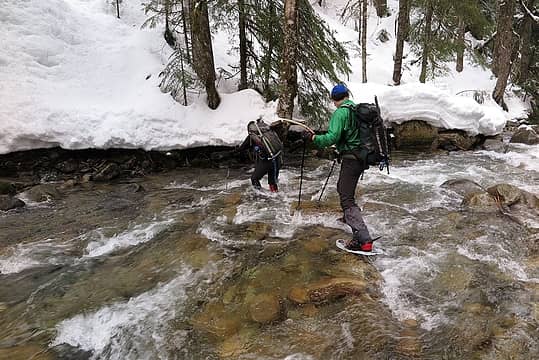 Snowshoe crossing of Trout Creek 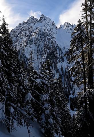 North face of Gunn Peak 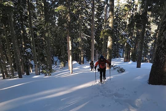 Hiking up the ridge 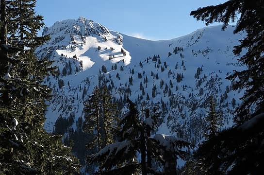 Townsend comes into view 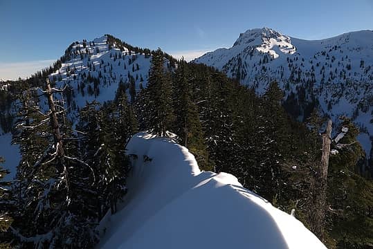 Narrow crest at 4780 feet, looking ahead to Burley's summit, with Townsend on the right 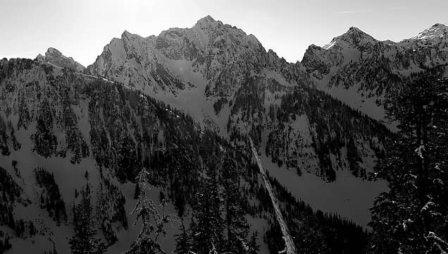 The tip of Baring, Merchant Peak, and Wing 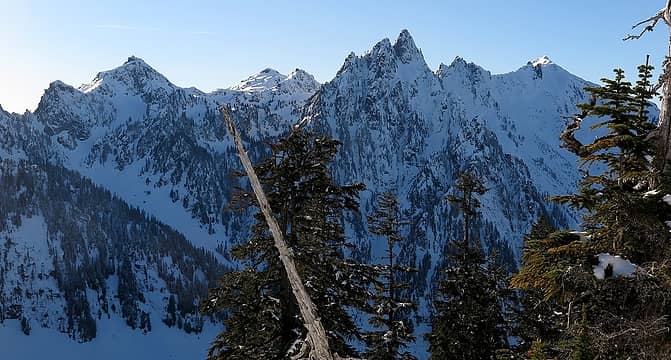 Wing, Tailgunner, Gunn & Gunnshy, all showing their steep northeast faces 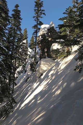 Examples of the impassable rock outcrops 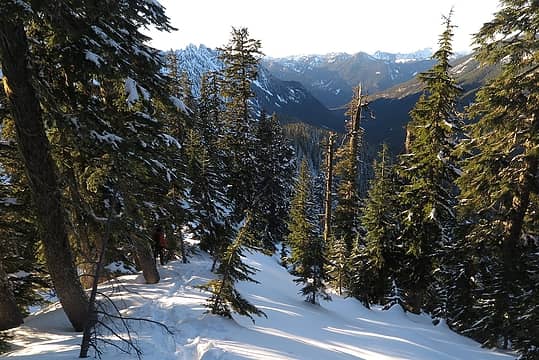 Hiking back down Burley's northwest ridge 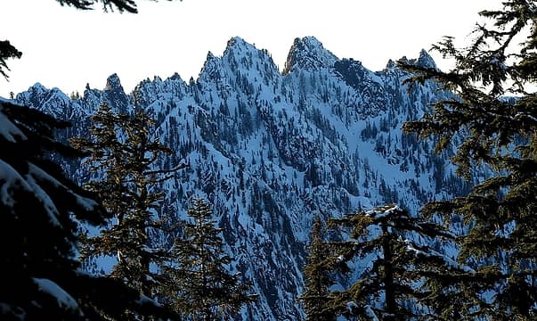 View of Jumpoff Ridge 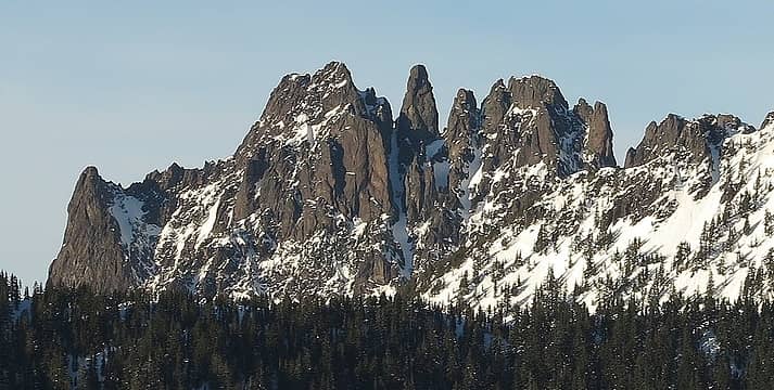 View of Spire Mountain 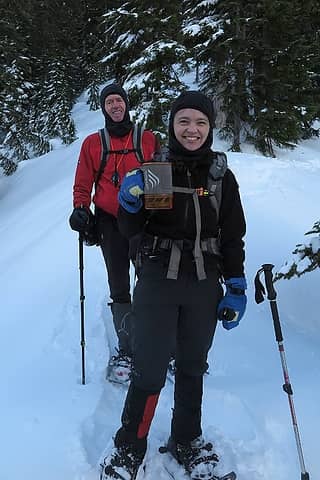 Yana hiking with her coffee stove 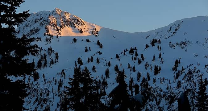 Evening light on Townsend 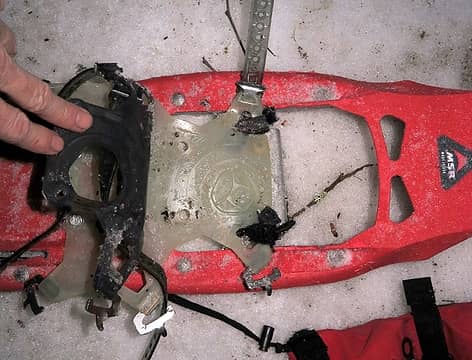 Final snowshoe repair of the day 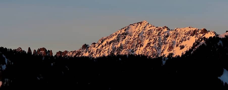 Alpenglow on Spire Benchmark 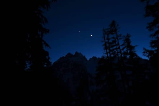 Stars appearing above Gunn Peak 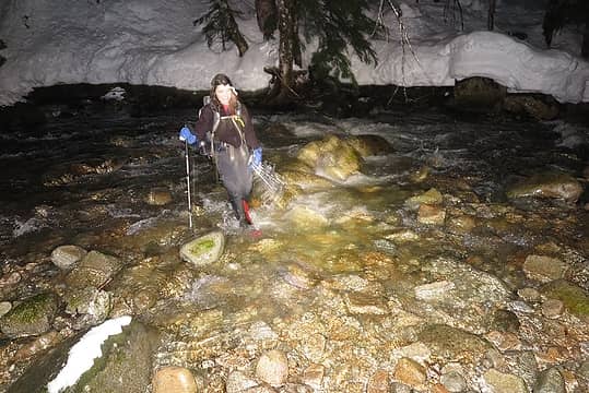 Night crossing of Trout Creek 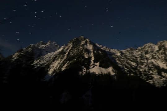 Moonlight on Merchant & Gunn, or Gunn & Gunnshy, I'm not sure
As beacons mountains burned at evening. J.R.R. Tolkien
As beacons mountains burned at evening. J.R.R. Tolkien
|
| Back to top |
  
|
|
RichP
Member

Joined: 13 Jul 2006
Posts: 5634 | TRs | Pics
Location: here |
|
RichP
Member
|
Sun Mar 05, 2017 6:57 am |
|
|
You guys sure got your exercise for the day. They don't call it Burley for nothin.' 
|
| Back to top |
|
|
Redwic
Unlisted Free Agent

Joined: 23 Feb 2009
Posts: 3292 | TRs | Pics
Location: Going to the Prom(inence) |
|
Redwic
Unlisted Free Agent
|
Sun Mar 05, 2017 7:15 am |
|
|
60 pounds lighter but not 60 points brighter.
|
| Back to top |
|
|
Distel32
Member

Joined: 03 Jun 2014
Posts: 961 | TRs | Pics
Location: Edmonds, WA |
|
Distel32
Member
|
Sun Mar 05, 2017 7:45 am |
|
|
|
| Back to top |
|
|
Brushbuffalo
Member

Joined: 17 Sep 2015
Posts: 1887 | TRs | Pics
Location: there earlier, here now, somewhere later... Bellingham in between |
Fine effort, you three.
I agree about service from MSR. They are tops for an equipment issue, as is OR. Some people say that good gear doesn't need a bombproof warranty. To them I would say they need to get out and work it more intensively ...maybe cross a few creeks with snowshoes on, etc. ☺
Passing rocks and trees like they were standing still
Passing rocks and trees like they were standing still
|
| Back to top |
|
|
Justus S.
Member
Joined: 17 Nov 2004
Posts: 1298 | TRs | Pics
Location: WA |
Nice Effort! Years back my brother and I did a winter scouting hike and made it to the flat /marsh at 3500ft below the lake. Been wanting to go back and make a serious attempt at getting to the Lake and Burley ever since. Glad to hear the road hike is still reasonable.
|
| Back to top |
|
|
zephyr
aka friendly hiker

Joined: 21 Jun 2009
Posts: 3370 | TRs | Pics
Location: West Seattle |
|
zephyr
aka friendly hiker
|
Sun Mar 05, 2017 1:47 pm |
|
|
| Matt wrote: | Yana crossing a side creek |
| Matt wrote: | Snowshoe crossing of Trout Creek |
That's some skillful snowshoeing there. Brrrrr.
Yes, the MSR folks are amazing for on the spot repairs. Matt, you might also start packing along some zip ties. They are good in a pinch. ~z
|
| Back to top |
|
|
Michael Lewis
Taking a nap
Joined: 27 Apr 2009
Posts: 629 | TRs | Pics
Location: Lynnwood, WA (for now) |
| Quote: | | It was already 3pm, but I was hopeful we could make the summit in another hour or so, for maybe a 16 hour day overall. |
Determination!
|
| Back to top |
|
|
puzzlr
Mid Fork Rocks

Joined: 13 Feb 2007
Posts: 7220 | TRs | Pics
Location: Stuck in the middle |
|
puzzlr
Mid Fork Rocks
|
Sun Mar 05, 2017 10:22 pm |
|
|
Wow! A huge effort. Too bad you weren't rewarded with the summit. I really enjoyed reading this report and following along on the map.
|
| Back to top |
|
|
mbravenboer
Member
Joined: 20 Oct 2013
Posts: 1422 | TRs | Pics
Location: Seattle |
 Great report! I love stubborn borderline stupid trips! Great report! I love stubborn borderline stupid trips!  . It does look like going via Sunset lake would perhaps work better yeah. . It does look like going via Sunset lake would perhaps work better yeah.
|
| Back to top |
|
|
Backpacker Joe
Blind Hiker

Joined: 16 Dec 2001
Posts: 23956 | TRs | Pics
Location: Cle Elum |
Nice effort guys. Is that road passable in the summer time? I was wondering whether it would be a good jump off for a Sunset lake trip?
Thanks.
"If destruction be our lot we must ourselves be its author and finisher. As a nation of freemen we must live through all time or die by suicide."
Abraham Lincoln
"If destruction be our lot we must ourselves be its author and finisher. As a nation of freemen we must live through all time or die by suicide."
Abraham Lincoln
|
| Back to top |
|
|
Stefan
Member

Joined: 17 Dec 2001
Posts: 5093 | TRs | Pics
|
|
Stefan
Member
|
Mon Mar 06, 2017 11:13 am |
|
|
Ditto with the effort. I am impressed.
|
| Back to top |
|
|
Nancyann
Member
Joined: 28 Jul 2013
Posts: 2319 | TRs | Pics
Location: Sultan Basin |
|
Nancyann
Member
|
Mon Mar 06, 2017 1:39 pm |
|
|
Backpacker Joe, the road is passable in the summer until you get a couple of miles up, then a major brush fest after that. This is probably the least worst time to go up as far as Matt and friends did. Great trip report, Matt. Beautiful area that very few people see.
|
| Back to top |
|
|
Steve Erickson
Member
Joined: 13 Jun 2005
Posts: 210 | TRs | Pics
Location: Next door to my neighbors |
I have hiked that road twice on my way into Sunset Lake but it was many years ago. Once off the road and over the creek, we side hilled most of the way toward the outlet from Sunset Lake. Prior to reaching the lake, you will pass by the old man made dam that was built to regulate the water in the lake and use for the mining operation below. Other than a long trip through a lot of brushy areas, did not run into any difficult areas that required any technical knowledge. The last time I hiked up to Burley Mountain was from the road off of Jacks Pass that was returned to "nature" several years ago. I believe if you wanted to get to Burley, this would be a much shorter route that what you chose. Otherwise your shortest option would be off of the trail that leads up Paradise Meadows, skirting Eagle Lake, and up and over Townsend.
|
| Back to top |
|
|
Yana
Hater

Joined: 04 Jun 2004
Posts: 4212 | TRs | Pics
Location: Out Hating |
|
Yana
Hater
|
Mon Mar 06, 2017 2:39 pm |
|
|
| Steve Erickson wrote: | | The last time I hiked up to Burley Mountain was from the road off of Jacks Pass that was returned to "nature" several years ago. I believe if you wanted to get to Burley, this would be a much shorter route that what you chose. |
Not this time of year (at least this year), it wouldn't! ;-)
I've actually been quite a ways up Burley from the Beckler River side, starting on a road that spurs off the Beckler River Road way before Jack's Pass. That was a few years ago - many of the roads up there were in surprisingly good shape.
BPJ - road would be fine without snow. Some of the blowdowns would be annoying, but there aren't that many of them. The crux is crossing Trout Creek at the 'end' of the road. I wouldn't go until the spring snow melt is good and done.
PLAY SAFE! SKI ONLY IN CLOCKWISE DIRECTION! LET'S ALL HAVE FUN TOGETHER!
PLAY SAFE! SKI ONLY IN CLOCKWISE DIRECTION! LET'S ALL HAVE FUN TOGETHER!
|
| Back to top |
|
|
|
|
You cannot post new topics in this forum
You cannot reply to topics in this forum
You cannot edit your posts in this forum
You cannot delete your posts in this forum
You cannot vote in polls in this forum
|
Disclosure: As an Amazon Associate NWHikers.net earns from qualifying purchases when you use our link(s). |


