| Previous :: Next Topic |
| Author |
Message |
RichP
Member


Joined: 13 Jul 2006
Posts: 5634 | TRs | Pics
Location: here |
|
RichP
Member
|
 Mon May 01, 2017 7:23 am |
|
|
With a rainy forecast for almost everywhere, we headed over to the sunny side to check on the flowers. From Ellensburg we took the Umptanum Rd and Wenas Rd over 3127' Ellensburg Pass and dropped down to the pastoral Wenas Valley to find Black Canyon Rd which is in pretty bad shape the last mile. You'll need good clearance and some patience to make it to the end of Black Canyon Rd which is 1.3 miles in length. Alternately, you can park at the wildlife gate and walk the last mile to the trailhead if you have a low slung vehicle.
The hiking is pleasant on an old roadbed up the meandering canyon before it joins another road system after 1.5 miles where we took a right at a fork. After the fork this is ORV territory but we saw no vehicles and only one other hiker on a sunny Sunday.
Balsamroot is nearing its peak and many other flowers are in various stages of bloom. Lots of grass widows, yellow bells and spring beauties are in the pine forest higher up. Lupine should begin to bloom within a week on the lower slopes of the ridges.
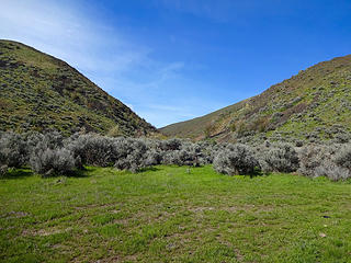 The entry to Black Canyon. 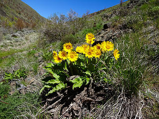 Balsamroot. 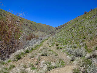 The trail is an old road. 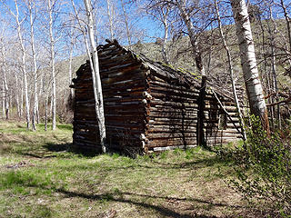 An old cabin along the way. 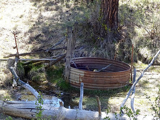 Spring on roadside. 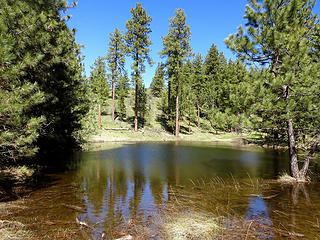 A small pond in the pine forest section. 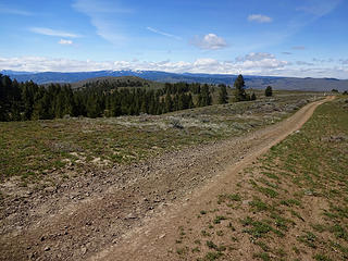 Umtanum Ridge. 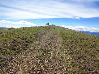 Rattler Benchmark, the highpoint of Umtanum Ridge. 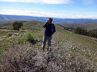 Mucho viento! 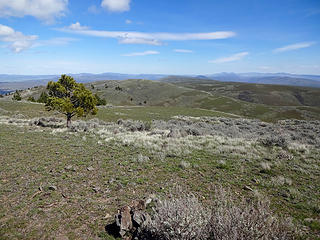 Looking east from Rattler Benchmark, 4224.' 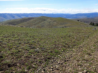 We followed the ridge down from Rattler Benchmark. 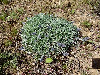 Lupine ready to bloom. 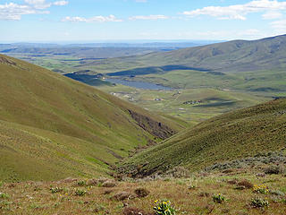 Spud Canyon and Wenas lake. 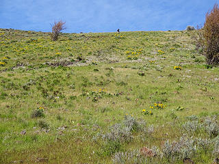 The bottom of the ridge that runs between Black and Spud Canyons. 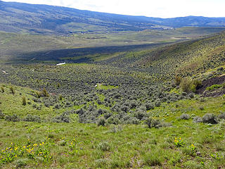 Back to the car at the mouth of Black Canyon to close the loop.
|
| Back to top |
  
|
|
Brushbuffalo
Member

Joined: 17 Sep 2015
Posts: 1887 | TRs | Pics
Location: there earlier, here now, somewhere later... Bellingham in between |
Nice! I love that ridge.  It looks like the flowers are blooming much more than just one week ago.
Passing rocks and trees like they were standing still
Passing rocks and trees like they were standing still
|
| Back to top |
|
|
wildernessed
viewbagger

Joined: 31 Oct 2004
Posts: 9275 | TRs | Pics
Location: Wenatchee |
Nice. There is a loop in "Best Desert Hikes Wa." that has two ridges running parallel and you can connect them on the top. I thought it was Hardy and Black Canyon loop ?
Living in the Anthropocene
Living in the Anthropocene
|
| Back to top |
|
|
RichP
Member
Joined: 13 Jul 2006
Posts: 5634 | TRs | Pics
Location: here |
|
RichP
Member
|
Tue May 02, 2017 5:30 am |
|
|
| wildernessed wrote: | | Nice. There is a loop in "Best Desert Hikes Wa." that has two ridges running parallel and you can connect them on the top. I thought it was Hardy and Black Canyon loop ? |
That right, Rob. It's across the valley on Cleman Mtn though. The gate to Hardy Canyon is almost directly across the road from the turnoff to Black Canyon. That should be open now since we are past May 1 which is when the wildlife closure season ends for this area.
The hike is called "Hardy and Big Burn Canyon Loop" in that book, I believe.
If you are feeling energetic, you can hike the ridge road all the way to the summit of Cleman from either canyon. That's a 20 mile round trip though and would qualify as an overnighter for us geezers, at least in my case. Lingering snow on the ridge top makes now a perfect time for this. I spied some sweet camp spots on my recent trip up there from the Naches side.
|
| Back to top |
|
|
flatsqwerl
Member

Joined: 23 Feb 2010
Posts: 1049 | TRs | Pics
Location: tacoma |
Those east side hills look so inviting when they are green. 
|
| Back to top |
|
|
wildernessed
viewbagger
Joined: 31 Oct 2004
Posts: 9275 | TRs | Pics
Location: Wenatchee |
| RichP wrote: | | If you are feeling energetic, you can hike the ridge road all the way to the summit of Cleman from either canyon. That's a 20 mile round trip though and would qualify as an overnighter for us geezers, at least in my case. Lingering snow on the ridge top makes now a perfect time for this. I spied some sweet camp spots on my recent trip up there from the Naches side. |
Thanks Rich a camp on top would be nice if you could melt some snow for water but time seems to be short for that trip now, eh ?
Living in the Anthropocene
Living in the Anthropocene
|
| Back to top |
|
|
RichP
Member
Joined: 13 Jul 2006
Posts: 5634 | TRs | Pics
Location: here |
|
RichP
Member
|
Tue May 02, 2017 7:17 am |
|
|
| wildernessed wrote: | | Thanks Rich a camp on top would be nice if you could melt some snow for water but time seems to be short for that trip now, eh ? |
You could be right about that but there are some springs to be found just below the ridge in some of the canyons. Check the map and you'll see them marked.
I'd be interested if you'd like to try this.
|
| Back to top |
|
|
feldychi
Member

Joined: 23 Jun 2010
Posts: 113 | TRs | Pics
|
|
feldychi
Member
|
Sun Apr 01, 2018 7:13 pm |
|
|
Hi there,
Thanks for your trip report. I am looking for something for the end of April to take a 13 year old on a first backpack. I love eastern WA and think we could do some version of this. Can you give more details on where the water is located? It has been years since I've been in Black Canyon.
Thanks,
Carrie
|
| Back to top |
|
|
RichP
Member
Joined: 13 Jul 2006
Posts: 5634 | TRs | Pics
Location: here |
|
RichP
Member
|
Sun Apr 01, 2018 7:32 pm |
|
|
| feldychi wrote: | | Can you give more details on where the water is located? |
The spring is located in the green area of the map in the upper canyon. I couldn't give you a pinpoint location, but it's where the pine forest begins and is right beside the road and hard to miss.
|
| Back to top |
|
|
feldychi
Member
Joined: 23 Jun 2010
Posts: 113 | TRs | Pics
|
|
feldychi
Member
|
Sun Apr 01, 2018 7:38 pm |
|
|
Thank you. Is this the Yakima DNR map? I don't have it....need to get it!
Thanks
|
| Back to top |
|
|
RichP
Member
Joined: 13 Jul 2006
Posts: 5634 | TRs | Pics
Location: here |
|
RichP
Member
|
Sun Apr 01, 2018 7:41 pm |
|
|
| feldychi wrote: | | Is this the Yakima DNR map? |
I'm not sure about that. I think you can print from CalTopo though.
|
| Back to top |
|
|
feldychi
Member
Joined: 23 Jun 2010
Posts: 113 | TRs | Pics
|
|
feldychi
Member
|
Thu Apr 12, 2018 8:26 am |
|
|
Thanks. Got the maps.
One last question......Does anyone have a suggestion for car camping the night before we start somewhere on the way to the TH. We are coming from Seattle and will be arriving in the evening. Or, even is there enough room to car camp at the TH?
Thanks, Carrie
|
| Back to top |
|
|
Mountainfisherman
Member
Joined: 26 May 2010
Posts: 123 | TRs | Pics
|
There is room to car camp at the TH although sometimes it unfortunately serves as a garbage dump. Seem to remember some yard waste there when we hiked it back in March-but you can find a place to camp there or off the road to the TH. Keep a look out for ticks.
|
| Back to top |
|
|
Schroder
Member

Joined: 26 Oct 2007
Posts: 6722 | TRs | Pics
Location: on the beach |
|
Schroder
Member
|
Fri Apr 13, 2018 4:07 pm |
|
|
There's a really nice campground about 5 miles from there up Wenas Creek (Auduban Rd). Do NOT go down Maloy Rd. The old guy in the first house will confront anyone driving down "his road".
|
| Back to top |
|
|
Mountainfisherman
Member
Joined: 26 May 2010
Posts: 123 | TRs | Pics
|
That campground, locally known as Cascade Park won't be open until May 1st. On the Maloy Road deal, the state was able to strike a deal with area landowners for access and have developed a camping area past the private land-some relatively nice outhouses as well. Again, that access closed to May 1.
|
| Back to top |
|
|
|
|


