| Previous :: Next Topic |
| Author |
Message |
raising3hikers
Member


Joined: 21 Sep 2007
Posts: 2344 | TRs | Pics
Location: Edmonds, Wa |
I drove up through Canada, then back down the Silver Skagit road to Ross Lake on Friday night. I wanted to camp near the Lake Hozomeen TH so I could get an early start on Saturday. Btw, The road is in great shape. I saw a familiar vehicle in the parking lot and left a note. Hey Wood!
On Saturday, I started hiking the Lake Hozomeen trail by 5:30am. The short portion of the trail that I followed was in good shape, only a couple of down trees. After 1.5 miles, I headed off trail to make a straight shot up towards the Hozomeen's, staying climbers left of the creek draining the S/Sw Pks. At first, the forest was easy enough to go through with minimal brush. I made decent time gaining elevation. Near the 4400' level, many more down logs and brush was encountered. At 5k, I started the short traverse to the basin I needed to get into to start climbing. The traverse was slow, lots of rock outcrops and steep side hilling but it went without too much of a problem. Finally, in the basin, I grabbed some water at the bottom of the snowfield 5400'.
I put crampons on for the next few hundred feet of snow, then the snow stopped and it was another 1000' of slabs and ledges to gain the S/SW Hozomeen saddle. The further up this basin, the steeper it got but despite the exposure, it wasn't too bad. I heard and saw a rock slide from the SW peak as I went up.
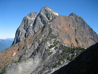 North Hozomeen 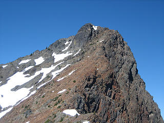 SW Hozomeen 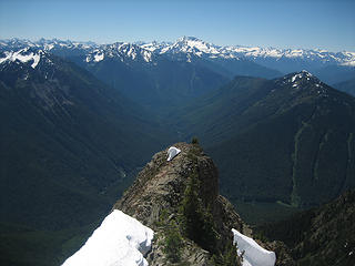 view to the south, Lightning creek drainage  looking up at South Hozomeen 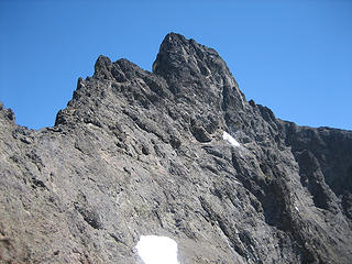 the final ridge to the summit 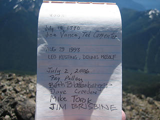 summit register from 1990 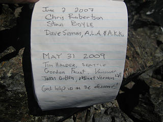 next page 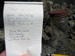 last page 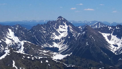 Castle Pk 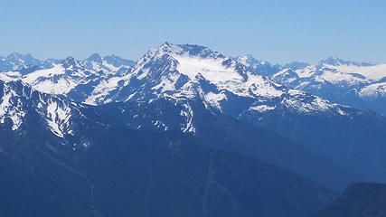 Jack Mtn 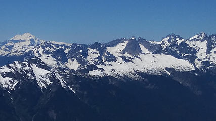 Baker to Spickard 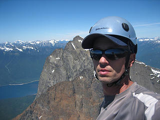 summit shot 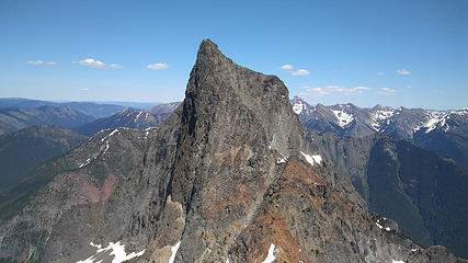 South Hozomeen from the Sw peak 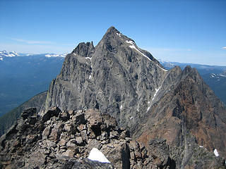 N Hozomeen 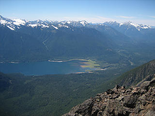 looking towards the North end of Ross Lake 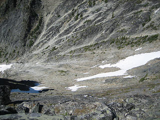 looking down the big rocky basin that I went up and have to go back down 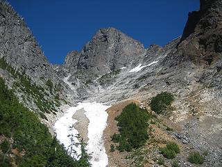 last look at S Hozo
|
| Back to top |
  
|
|
Tom_Sjolseth
Born Yesterday

Joined: 30 May 2007
Posts: 2652 | TRs | Pics
Location: Right here. |
Nice little dayhike jaunt! Thanks for the great memories with that register shot.
|
| Back to top |
|
|
RichP
Member

Joined: 13 Jul 2006
Posts: 5633 | TRs | Pics
Location: here |
|
RichP
Member
|
 Sun Jun 25, 2017 6:04 pm |
|
|
| raising3hikers wrote: | | It was hot, the mosquitos were out and it seemed like the brush was way worse than on the way up. I was poked with sharp, dead sticks while slipping on slick duff and branches. Sweat poured off of me as I was out of water by the time I reached the creek crossing at 2360'. |
You make it sound so fun.  Great work on getting that one. Great work on getting that one.
|
| Back to top |
|
|
Fletcher
Member

Joined: 29 Jul 2009
Posts: 1870 | TRs | Pics
Location: kirkland |
|
Fletcher
Member
|
Sun Jun 25, 2017 6:19 pm |
|
|
Really cool. It sounds gnarly up there. Is the entire crux pitch unprotectable? Maybe not bother bringing gear if so?
|
| Back to top |
|
|
raising3hikers
Member
Joined: 21 Sep 2007
Posts: 2344 | TRs | Pics
Location: Edmonds, Wa |
| Fletcher wrote: | | Really cool. It sounds gnarly up there. Is the entire crux pitch unprotectable? Maybe not bother bringing gear if so? |
I didn't see anything that I could place anything. It was a go since the big ledge was only a short distance beneath me. the pitch is only 12'-15' with the hardest part near the start. the holds and angle get better near the top. I would have brought a shorter rope for the rappel, my 60m was way too much
|
| Back to top |
|
|
awilsondc
Member

Joined: 03 Apr 2016
Posts: 1324 | TRs | Pics
|
|
| Back to top |
|
|
mbravenboer
Member
Joined: 20 Oct 2013
Posts: 1422 | TRs | Pics
Location: Seattle |
Love that photo of the view into the lightning creek drainage!
I think my healthy fear of heights will prevent me from ever achieving this unfortunately  . .
|
| Back to top |
|
|
iron
Member

Joined: 10 Aug 2008
Posts: 6392 | TRs | Pics
Location: southeast kootenays |
|
iron
Member
|
Sun Jun 25, 2017 9:31 pm |
|
|
yeah, after you told me you were car camping, i knew this would turn into a daytrip. moral of the story: any trip under 30 miles or 14000ft is fair game for your daytrips with an alpine start. time to sell your camping gear!
looks like the route up jack is still possibly in. can barely make out angel wing. really cool view of snowfield group.
most important question? is it on the DNR list?
|
| Back to top |
|
|
Stefan
Member

Joined: 17 Dec 2001
Posts: 5091 | TRs | Pics
|
|
Stefan
Member
|
Sun Jun 25, 2017 9:58 pm |
|
|
Dude. You are starting to defile intimidating climbs!
|
| Back to top |
|
|
puzzlr
Mid Fork Rocks

Joined: 13 Feb 2007
Posts: 7220 | TRs | Pics
Location: Stuck in the middle |
|
puzzlr
Mid Fork Rocks
|
Mon Jun 26, 2017 1:03 am |
|
|
Congrats -- your register photos prove how rarely this is climbed, and we can all see why. 
|
| Back to top |
|
|
wildernessed
viewbagger

Joined: 31 Oct 2004
Posts: 9275 | TRs | Pics
Location: Wenatchee |

Living in the Anthropocene
Living in the Anthropocene
|
| Back to top |
|
|
Distel32
Member
Joined: 03 Jun 2014
Posts: 961 | TRs | Pics
Location: Edmonds, WA |
|
Distel32
Member
|
Mon Jun 26, 2017 8:13 pm |
|
|
|
| Back to top |
|
|
Mesahchie Mark
A Lerxst

Joined: 10 May 2005
Posts: 700 | TRs | Pics
Location: In Wonderland |
Well done!
|
| Back to top |
|
|
Dave Creeden
Member
Joined: 04 Sep 2007
Posts: 99 | TRs | Pics
|
What a beast! First you solo Lincoln Peak and now SE Hozomeen Peak (along with SW peak on the same day). Mike T. and I still have one up one you though, in that we climbed Lincoln Peak and South Hozomeen on consecutive weekends - so there!
In early July 2006 when our group climbed South Hozomeen it was extremely dry, so we had to claw out a spot on a slope for our bivy sacks at about 6,500 feet, near a trickle of water in the gully.
On the descent, once our group reached the ledges on upper west side of South Hozomeen, I took off ahead of the rest of the group to get down to the obscure location in the gulley next to our bivy site, before it got dark. It was like a live firing range as I descended, as fellow climbing partners unavoidably kicked loose debris, with pebbles whistling by me and occasionally striking my pack back and helmet.
I led the 15 foot, 5.6 section and your right, there is no place to place protection.
After I belayed Beth and then Fay through this section, they continued on to the summit block as I belayed Mike and Jim up. Beth had nearly reached the top of the gulley just below summit, when Fay began to ascent the gulley. Beth kicked loose a small rock, which struck the crown of Fay's helmet. So yea, there is plenty of loose rock on South Hozomeen. It's just not as big a problem when climbing solo.
Someone asked if South Hozomeen is on the DNR list. Not only is it on the list, it is a flip of a coin on whether South Hozomeen or SE Mox is at the top of the list. Nooksack Tower could very well rank first on the DNR list, but I haven't climbed it so I can only go by its reputation.
Did you see any pitons, from Fred's first ascent? We came across 2 or 3 pitons.
|
| Back to top |
|
|
raising3hikers
Member
Joined: 21 Sep 2007
Posts: 2344 | TRs | Pics
Location: Edmonds, Wa |
dave, thanks for your quick story of your trip up there, it's quite the memorable mountain for sure! I did ask a couple people if they were interested in climbing with me but wasn't too worried going solo because that way it eliminates the rock fall risk kicked by a partner as your group found out. I saw 1 piton on my way down, didn't see it on the way up as I must have scrambled a slightly different way.
I can't quite say i'd never climb S Hozo again, but now having done it, I don't have a good reason to go back. Most peaks are on my DNR list because there's always something else new to climb. For some odd reason, I enjoyed the upper part of the mountain. maybe because leading up to the trip I had thought it would be much worse but ended up being easier than I expected. I guess it's good to set the bar low sometimes so it's easy to be pleasantly surprised:) The views weren't bad either
|
| Back to top |
|
|
|
|


