| Previous :: Next Topic |
| Author |
Message |
Klapton
Member


Joined: 21 Dec 2006
Posts: 940 | TRs | Pics
|
|
Klapton
Member
|
 Mon Sep 10, 2007 7:48 pm |
|
|
MLS listing #27111550
Snohomish County parcel #10010000003000
Real Estate Listing
Snohomish County Parcel Data says, "SEC 27 TWP 29 RGE 11 ID-25) MONTE CRISTO MINING DIST INDEPENDENCE 1776 LODE DES AS SURVEY 175."
This article (among others) says...
| Quote: | | In 1874, the first prospectors staked claims on both forks of Silver Creek in Western Washington. But the mother lode was just over the next hill. In early summer, Joseph Pearsall spotted a promising peak that looked like galena, which usually contained silver. He collected some samples and gave them to his friend Frank Peabody, who had them assayed in Seattle.
The samples were promising enough that their friend MacDonald Wilmans gave them a $150 grubstake. The first claim they called Independence of 1776. |
And it can be YOURS for $40,000!
The realtor I contacted about it said the only structures that could be built there would have to be related to the mining claim. Of course, if you were going to mine there, you would need to have a lovely log cabin with PV and wind power and satellite internet, right?
Of course... I asked about structures in an email BEFORE I found out where it actually was (used the county parcel mapper online once I had the parcel number). This online map tool for permit info has more bells and whistles than the other parcel search map. Clickie the link, and search for that parcel number above... (not recommended for dial up folks, and you must be patient and only check one box at a time, etc. I recommend turning off the elevation shading, and turn on the contours!)
This first picture... It's not the view FROM the property... It's the view OF the property!
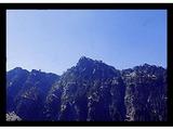   

|
| Back to top |
  
|
|
Snowbrushy
Member

Joined: 23 Jul 2003
Posts: 6670 | TRs | Pics
Location: South Sound |
Hmmm, I'm thinking...
Does anyone know if there is a level cabin site at the parcel?
(Edit): Actually, I think that Jake should buy it. 
Oh Pilot of the storm who leaves no trace Like thoughts inside a dream Heed the path that led me to that place Yellow desert stream.
Oh Pilot of the storm who leaves no trace Like thoughts inside a dream Heed the path that led me to that place Yellow desert stream.
|
| Back to top |
|
|
Klapton
Member
Joined: 21 Dec 2006
Posts: 940 | TRs | Pics
|
|
Klapton
Member
|
Tue Sep 11, 2007 10:25 am |
|
|
I don't know about this site in particular. I didn't find any historical pictures of THIS one in particular. The "Comet" mine, atop the same peak somwhere had several structures perched precariously on the mountain. They ran a cable-bucket down the mountain to transfer supplies up, and ore out. They had a bunkhouse, a cookhouse, and an outhouse up there.
Currently the gated road to Monte Cristo is out, so you'ld have to pack in your tools and materials for about 4 miles to the town site BEFORE climbing 2700 feet almost straight up with it, hehe.
|
| Back to top |
|
|
hyak.net
Member

Joined: 18 Dec 2003
Posts: 143 | TRs | Pics
Location: Hyak, WA |
|
hyak.net
Member
|
Tue Sep 11, 2007 12:34 pm |
|
|
| Klapton wrote: | | I don't know about this site in particular. I didn't find any historical pictures of THIS one in particular. The "Comet" mine, atop the same peak somwhere had several structures perched precariously on the mountain. They ran a cable-bucket down the mountain to transfer supplies up, and ore out. They had a bunkhouse, a cookhouse, and an outhouse up there.
Currently the gated road to Monte Cristo is out, so you'ld have to pack in your tools and materials for about 4 miles to the town site BEFORE climbing 2700 feet almost straight up with it, hehe. |
I wonder if it could be accessed with a dual-sport motorcycle?
|
| Back to top |
|
|
Klapton
Member
Joined: 21 Dec 2006
Posts: 940 | TRs | Pics
|
|
Klapton
Member
|
Tue Sep 11, 2007 2:56 pm |
|
|
|
| Back to top |
|
|
Jake
Member
Joined: 13 Jun 2004
Posts: 257 | TRs | Pics
Location: monroe, Wa. |
|
Jake
Member
|
Tue Sep 11, 2007 5:49 pm |
|
|
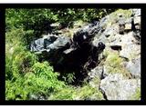
The mine is the Independence of 1776 (76 mine for short). Not only nothing level there that could be built on without avalanche danger, but it may be on the hit list for a clean up which would involve the owners finances.
Two mines in 76 Gulch are said to be on the hit list and I would assume that would be one of them.
|
| Back to top |
|
|
Snowbrushy
Member
Joined: 23 Jul 2003
Posts: 6670 | TRs | Pics
Location: South Sound |
| Jake wrote: | | The mine is the Independence of 1776 |
Jake, I've always thought that you should be the Moderator here on NWHikers History Forum.
Oh Pilot of the storm who leaves no trace Like thoughts inside a dream Heed the path that led me to that place Yellow desert stream.
Oh Pilot of the storm who leaves no trace Like thoughts inside a dream Heed the path that led me to that place Yellow desert stream.
|
| Back to top |
|
|
Jake
Member
Joined: 13 Jun 2004
Posts: 257 | TRs | Pics
Location: monroe, Wa. |
|
Jake
Member
|
Tue Sep 11, 2007 7:28 pm |
|
|
Thanks, but no thanks Snowbrushy. I have plenty to do here. Seldom even get time to check the site out any more.
|
| Back to top |
|
|
Snowbrushy
Member
Joined: 23 Jul 2003
Posts: 6670 | TRs | Pics
Location: South Sound |
Your contributions are always something that I look forward to, Jake. Your work is wonderful and will be loved for generations to come!
Oh Pilot of the storm who leaves no trace Like thoughts inside a dream Heed the path that led me to that place Yellow desert stream.
Oh Pilot of the storm who leaves no trace Like thoughts inside a dream Heed the path that led me to that place Yellow desert stream.
|
| Back to top |
|
|
marionthegoat
That's a trail ??

Joined: 29 May 2007
Posts: 240 | TRs | Pics
Location: Ferndale, WA |
Probably no future for this hole in the ground.... Gold recently hit $700 per troy ounce, but the Monte Cristo and neighboring districts to the south are predominantly silver, which continues to poke along at about $12 per oz. Takes a lot of metal at that price to pay for costs of development, cleanup, permits, logistics, red tape, etc. Add the rather inacessible location and short operating season, and you've got a historically interesting place which I doubt anyone wants to develop for profit. 
|
| Back to top |
|
|
Jimbo
Member

Joined: 14 Feb 2005
Posts: 1558 | TRs | Pics
Location: Arlington |
|
Jimbo
Member
|
Tue Sep 18, 2007 7:24 am |
|
|
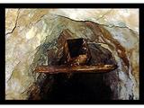
Hey Jake, that adit don't look anything like the one's we did up there..
Guns only have two enemies; rust and politicians
Guns only have two enemies; rust and politicians
|
| Back to top |
|
|
Jake
Member
Joined: 13 Jun 2004
Posts: 257 | TRs | Pics
Location: monroe, Wa. |
|
Jake
Member
|
Tue Sep 18, 2007 12:59 pm |
|
|
That be it Jimbo. The Independence of 1776 Mine.
Forget buying it. Someone is going to have to puke out some big bucks for site cleanup. Could go into the six figure range. You don't want to be the one holding the paper on it when that time comes.
Pictures can be deceiving. It's the same one you, 2DRX, and I believe H.Hound were in.
|
| Back to top |
|
|
H. Hound
Member

Joined: 09 May 2003
Posts: 1205 | TRs | Pics
Location: Exit 32 |
|
H. Hound
Member
|
Tue Sep 18, 2007 2:32 pm |
|
|
Ya, the X-Man ever did a report on that one.
76 gulch is a lovely walk in the fall.
|
| Back to top |
|
|
Jeepasaurusrex
Member

Joined: 05 Oct 2004
Posts: 1079 | TRs | Pics
Location: Arlington, WA |
I remember hiking into the Sherridan mine when I was a kid. A friend of ours owned it. I also remember hiking over that saddle between the two peaks to the lakes beyond it. GREAT trout fishing!.
"I would like to see things from your point of view, but I cannot get my head that far up my butt"
"I would like to see things from your point of view, but I cannot get my head that far up my butt"
|
| Back to top |
|
|
Mine Explorer
Member

Joined: 19 Aug 2012
Posts: 175 | TRs | Pics
|
|
| Back to top |
|
|
|
|


