| Previous :: Next Topic |
| Author |
Message |
wildernessed
viewbagger


Joined: 31 Oct 2004
Posts: 9275 | TRs | Pics
Location: Wenatchee |
Location : West of Twisp beginning at the War Creek TH
Maps : GTM - Buttermilk Butte, TOPO (outdated)
Stats : 16 mi., 6400' r/t
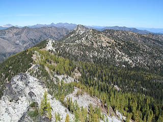
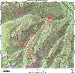 Black Ridge - Snowshoe Ridge - Lake via SF War Creek 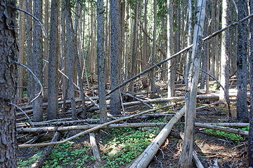 This picture pretty much sums up the terrain of the entire trip. 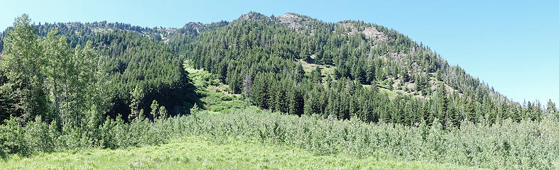 Lower Black Ridge from below. 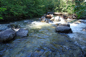 War Creek crossing. 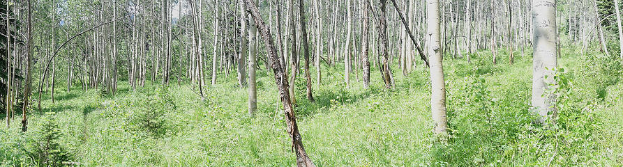 Aspen grove in one of the meadows above South Fork of War Creek. 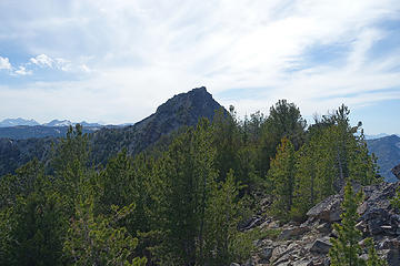 Once on Black Ridges crest. 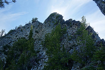 Final summit route to Black Ridges highpoint. 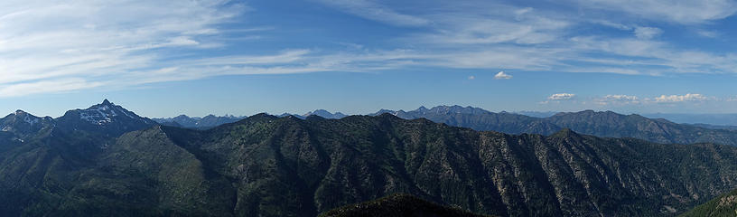 Camels Hump to Canyon Creek Ridge. 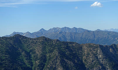 Abernathy's, Gardner Ridge, Storey and more from near Black ridge's summit. 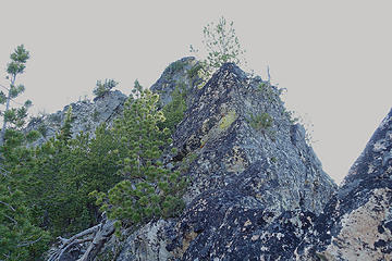 Lower section of Black Ridge's summit ridge. 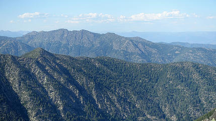 Midnight Mountain 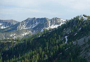 Sun Mountain from Black Ridge. 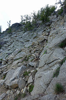 Midway up Black Ridges summit from the East the fist dirty gully. 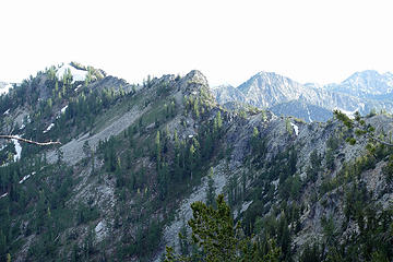 Black Ridge between Black Ridges summit heading South towards Sun Mountain. 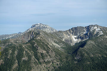 4 labels Oval and Snowshoe Ridge with the basins of Upper and Lower Snowshoe Lakes. 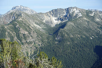 Lower Snowshoe lake below Snowshoe Ridge. 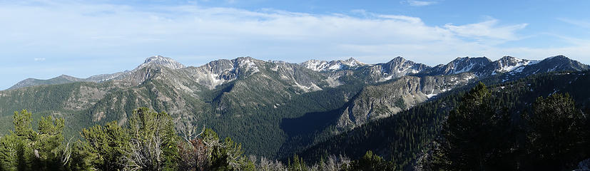 Overlapping ridges and peaks. Buttermilk Ridge, Snowshoe Ridge,Sawtooth Ridge, Black Ridge. 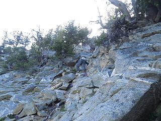 Early gully up Black Ridges summit. This topped out and dropped down to a very steep gully so I took pictures below the summit. 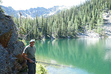 Steve resting his arm and catching his breath. 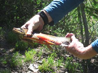 Even though I dirtied him up a bit good color and size, 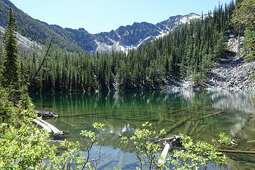 Lower Snowshoe Lake. Never forget. 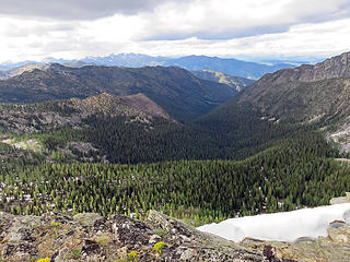 South Fork of War Creek drainage between Snowshoe and Black Ridges.
Living in the Anthropocene
Living in the Anthropocene
|
| Back to top |
  
|
|
raising3hikers
Member

Joined: 21 Sep 2007
Posts: 2344 | TRs | Pics
Location: Edmonds, Wa |
you guys are quite the fisherman or just know where they're hungry 
|
| Back to top |
|
|
Abert
Member
Joined: 02 Sep 2010
Posts: 588 | TRs | Pics
Location: Sequim |
|
Abert
Member
|
 Sun Jul 09, 2017 5:40 pm |
|
|
Black Ridge from Sun Mountain and Snowshoe. Farther than I had the time (or energy) for. And that was without the heat.
 Black Ridge 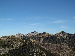 Black Ridge
|
| Back to top |
|
|
wildernessed
viewbagger
Joined: 31 Oct 2004
Posts: 9275 | TRs | Pics
Location: Wenatchee |
| Abert wrote: | | Black Ridge from Sun Mountain and Snowshoe. |
Nice shots !
Living in the Anthropocene
Living in the Anthropocene
|
| Back to top |
|
|
HitTheTrail
Member

Joined: 30 Oct 2007
Posts: 5460 | TRs | Pics
Location: 509 |
Wow! By wow I mean I am glad I went on an easy hike with Leafguy instead. for the effort and perseverance.
|
| Back to top |
|
|
RichP
Member

Joined: 13 Jul 2006
Posts: 5634 | TRs | Pics
Location: here |
|
RichP
Member
|
Sun Jul 09, 2017 7:17 pm |
|
|
Steve is a veritable encyclopedia of knowledge about old and abandoned trails. He should write a book.
|
| Back to top |
|
|
sooperfly
Member

Joined: 04 May 2003
Posts: 1234 | TRs | Pics
Location: North Central Wa. |
Thanks for report, good to see the fishies doing well! - Jackchinook and I planted it in 2011.
Oh, and by the way, those are westslope cutthroat, not rainbows.  Here's a pic from that September day trip. Your weather looked a lot nicer!
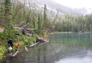 planting-fish
|
| Back to top |
|
|
wildernessed
viewbagger
Joined: 31 Oct 2004
Posts: 9275 | TRs | Pics
Location: Wenatchee |
| RichP wrote: | | Steve is a veritable encyclopedia of knowledge about old and abandoned trails. He should write a book. |
Yes he has always been the exploring type when I hear the word "recon" I know we will eventually end up somewhere farther than we imagined a new and different place.
Living in the Anthropocene
Living in the Anthropocene
|
| Back to top |
|
|
wildernessed
viewbagger
Joined: 31 Oct 2004
Posts: 9275 | TRs | Pics
Location: Wenatchee |
| sooperfly wrote: | | Thanks for report, good to see the fishies doing well! - Jackchinook and I planted it in 2011.
Oh, and by the way, those are westslope cutthroat, not rainbows. |
Thanks there are various sizes so they are reproducing i told Steve during our ascent there was a reason you came over the top. 
Living in the Anthropocene
Living in the Anthropocene
|
| Back to top |
|
|
Get Out and Go
Member

Joined: 13 Nov 2004
Posts: 2128 | TRs | Pics
Location: Leavenworth |
I'm exhausted just reading the TR. I had to re-hydrate with a beer and take a nap afterwards. 
"These are the places you will find me hiding'...These are the places I will always go."
(Down in the Valley by The Head and The Heart)
"Sometimes you're happy. Sometimes you cry.
Half of me is ocean. Half of me is sky."
(Thanks, Tom Petty)
"These are the places you will find me hiding'...These are the places I will always go."
(Down in the Valley by The Head and The Heart)
"Sometimes you're happy. Sometimes you cry.
Half of me is ocean. Half of me is sky."
(Thanks, Tom Petty)
|
| Back to top |
|
|
wildernessed
viewbagger
Joined: 31 Oct 2004
Posts: 9275 | TRs | Pics
Location: Wenatchee |
| Get Out and Go wrote: | | I'm exhausted just reading the TR. I had to re-hydrate with a beer and take a nap afterwards. |
Yeah those trips are catching up with me, my mind wants to do things a younger and healthier body once did hot days are my kryptonite with the medicine I take I cycle through periods where I just want to run vs. hike / backpack.
Living in the Anthropocene
Living in the Anthropocene
|
| Back to top |
|
|
iron
Member

Joined: 10 Aug 2008
Posts: 6392 | TRs | Pics
Location: southeast kootenays |
|
iron
Member
|
Tue Jul 11, 2017 8:59 am |
|
|
the forest travel looked enjoyable.
|
| Back to top |
|
|
wildernessed
viewbagger
Joined: 31 Oct 2004
Posts: 9275 | TRs | Pics
Location: Wenatchee |
| iron wrote: | | the forest travel looked enjoyable. |
And then there is your genre of hiker / backpacker / peakbagger / mountaineer you guys eat that stuff up. I took several pics because it was just an incredible mess, when that place finally burns it might last through the winter.
Living in the Anthropocene
Living in the Anthropocene
|
| Back to top |
|
|
wildernessed
viewbagger
Joined: 31 Oct 2004
Posts: 9275 | TRs | Pics
Location: Wenatchee |
Another interesting part to this trip is the trail keeps heading up the drainage and we didn't know why it would we didn't see any old trails on the maps going that far so while we followed it through all the blow down why it was going our way when it was time for us to head up into the basin we took the route we planned arcing up the path of least resistance into the basin we camped at. Along the way we ran into a series of switchbacks and figured the trail eventually turned upward and switch backed up into the basin and onto the ridge. There was no advantage to following the obstructed trail vs heading off trail. Steve figured it was the route up to the Black Ridge Lookout removed in 1952.
Living in the Anthropocene
Living in the Anthropocene
|
| Back to top |
|
|
wildernessed
viewbagger
Joined: 31 Oct 2004
Posts: 9275 | TRs | Pics
Location: Wenatchee |
| Abert wrote: | Black Ridge from Sun Mountain and Snowshoe. Farther than I had the time (or energy) for. And that was without the heat.
Black Ridge Black Ridge |
In hind site Sun was just up the drainage but we expended our energy on our primary objectives and at the time the terrain and heat didn't make it appealing. I think from a low point on Snowshoe Ridge just before Battle you could drop down then side hill over to Sun maybe looping over Sawtooth Ridge at Eagle Pass and around back via Tuckaway, Gray, and Upper Eagle to your original TH.
Living in the Anthropocene
Living in the Anthropocene
|
| Back to top |
|
|
|
|


