| Previous :: Next Topic |
| Author |
Message |
puzzlr
Mid Fork Rocks


Joined: 13 Feb 2007
Posts: 7220 | TRs | Pics
Location: Stuck in the middle |
|
puzzlr
Mid Fork Rocks
|
 Thu Jun 25, 2015 12:55 am |
|
|
I just got back from a climb up Summit Chief and the PCT just below Vista Tarns goes through a snag forest from a relatively recent burn. I assumed this was part of the 2009 Lemah Meadows burn that closed the PCT for a year, but it's not. The PCT segment climbing Escondido Ridge was part of the detour route at that time. I found lots of online references to the 2009 Lemah Fire, but none for the burn high on Escondido Ridge. Does anyone remember this or can provide a link to a contemporary account?
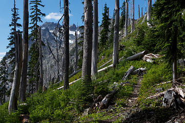 Escondido burn 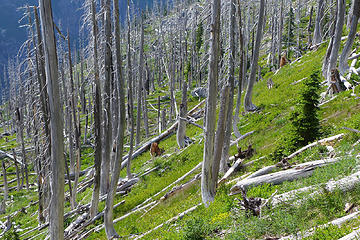 Escondido burn 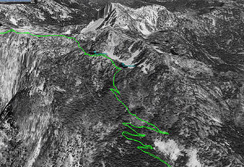 1 label Escondido Ridge below Vista Tarns was not burnt out in 1998 imagery 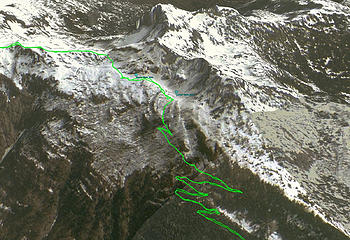 1 label Escondido Ridge below Vista Tarns IS burnt out in 2003 imagery 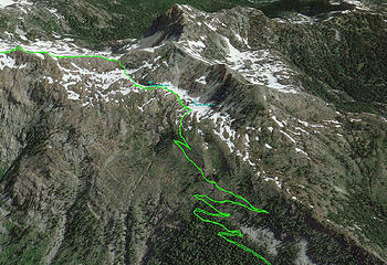 1 label Most recent 2014 imagery of Escondido Ridge showing burnt area.
|
| Back to top |
  
|
|
monorail
Member

Joined: 06 May 2012
Posts: 267 | TRs | Pics
|
|
monorail
Member
|
Thu Jun 25, 2015 7:39 am |
|
|
My impression is that it burned in 1994, but I don't know how to account for the google image. I hiked that section of the PCT in 2004, and there were lots of wildflowers and new life among the blackened snags--- not all that different from your recent photos, actually. Regrowth happens very slowly at that altitude/snowpack, so what I saw seemed consistent with a fire 10 years earlier (but I'm not an expert on these things). And I think several guidebooks referred to a fire in 1994.
Is it possible that the historical google image has the wrong date? Or maybe the dark areas that look like forest are actually something else, like blackened debris on the ground?
Whenever it happened, that recovery area is one of the most beautiful places I've ever seen--- the contrast of wildflowers and new greenery against the blackened snags is really breathtaking.
|
| Back to top |
|
|
gb
Member
Joined: 01 Jul 2010
Posts: 6310 | TRs | Pics
|
|
gb
Member
|
Thu Jun 25, 2015 7:50 am |
|
|
You are correct that that fire (and many others) were in mid-summer, 1994. I visited the ridge line of Summit Chief and the lakes below in late August of 1995 with a friend and her 3 mo. old Golden Retriever. We were surprised by the burn which was so very hot that it completely burnt out the meadow and followed the roots of trees at the top of the ridge.
History of 1994 fires in Leavenworth
If I recall the idiot who stared the Icicle Fire by burning brush was later prosecuted. The price exacted from his hide could not have been near enough for the devastation the fool caused.
|
| Back to top |
|
|
Randito
Snarky Member

Joined: 27 Jul 2008
Posts: 9513 | TRs | Pics
Location: Bellevue at the moment. |
|
Randito
Snarky Member
|
Thu Jun 25, 2015 8:28 am |
|
|
FWIW:I hiked that section in 2001 and it was burned then.
|
| Back to top |
|
|
puzzlr
Mid Fork Rocks
Joined: 13 Feb 2007
Posts: 7220 | TRs | Pics
Location: Stuck in the middle |
|
puzzlr
Mid Fork Rocks
|
Fri Jun 26, 2015 12:21 am |
|
|
| monorail wrote: | | Is it possible that the historical google image has the wrong date? |
I'm quite sure the date is correct. Some of the same imagery is available in the DOQ dataset at http://earthexplorer.usgs.gov/ and the date Google Earth shows agrees with the metadata there.
I also wonder about the dark area -- it doesn't look quite the same as the parts that didn't burn.
|
| Back to top |
|
|
Mark Griffith
(Embrace yourself)

Joined: 14 Mar 2005
Posts: 853 | TRs | Pics
Location: Issaquah |
I was up in the Waptus burn area this past weekend and was struck wondering again when this fire occurred. Google book cache results mention a 1929 fire but I can't see any details about it.
Curious I ended up paying to search through the Seattle PI archives
http://nl.newsbank.com/nl-search/we/Archives/?p_product=HA-SE&p_theme=histpaper&p_action=keyword
and found no reference to a 1929 fire but did find mention of 1936 fire in a "blind" area of the Waptus river and a 30 acre fire in Pete Lake...
Anyone have any more info on the Waptus Burn?
|
| Back to top |
|
|
Chico
Member

Joined: 30 Nov 2012
Posts: 2500 | TRs | Pics
Location: Lacey |
|
Chico
Member
|
Mon Oct 02, 2017 10:43 pm |
|
|
I was on a fire heading in to Pete Lake in 1979. Nothing real recent heading in to Waptus that I recall. The "Waptus Burn" was in 1929 regardless of what the PI has.
|
| Back to top |
|
|
Billoutwest
Member
Joined: 01 Aug 2011
Posts: 260 | TRs | Pics
Location: Redmond Oregon |
| gb wrote: | | You are correct that that fire (and many others) were in mid-summer, 1994. I visited the ridge line of Summit Chief and the lakes below in late August of 1995 with a friend and her 3 mo. old Golden Retriever. We were surprised by the burn which was so very hot that it completely burnt out the meadow and followed the roots of trees at the top of the ridge. |
I was up in that general area in the fall of 1974 working on BARE rehab projects.
Not up on that ridge but there was a huge fire event that year.
One thought is that ridge may have burned twice.
Fires come in multi event cycles typically.
Growth
Insect or disease
Perhaps drought sponsored
First Large Fire
Second Large Fire
Growth
That is a somewhat common forest fire rotation.
Not everything burns in the first fire.
A good portion of what burns in the first fire is killed and adds to the destruction of the second fire.
I say destruction because fires with large woody debris on the ground have the soils 'nuked' and recovery at elevation is beyond our lifetimes.
=====
anyway
Don't be afraid to look for multiple fire 6 - 10 years apart for what you see today.
|
| Back to top |
|
|
|
|


