| Previous :: Next Topic |
| Author |
Message |
Abert
Member


Joined: 02 Sep 2010
Posts: 588 | TRs | Pics
Location: Sequim |
|
Abert
Member
|
 Tue Nov 28, 2017 5:43 pm |
|
|
So where is the highest point of the mountain? Bivouac.com, Peakbagger and some trip reports on this site say it's in Canada. ListsofJohn says it's in the US. The maps (the ones that I've seen, at least) and the new Andrew Kirmse prominence database say it's in the US.
|
| Back to top |
  
|
|
Randito
Snarky Member

Joined: 27 Jul 2008
Posts: 9514 | TRs | Pics
Location: Bellevue at the moment. |
|
Randito
Snarky Member
|
Tue Nov 28, 2017 7:30 pm |
|
|
Not sure why there is confusion:
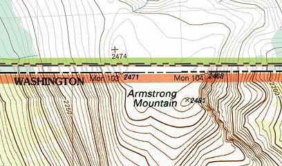 Armstrong | Quote: | | The main summit is in the US |
There is some babbling about summit cairns -- but those don't really count a the height of the mountain eh? -- I mean if the height can be changed by building cairns -- it's flat.
Besides wandering around in the flattish, tundraish summit region is kinda fun and CBP didn't seem to care about us wandering over and back in the area around Monument 104 when we were up there in 2011
|
| Back to top |
|
|
Stefan
Member

Joined: 17 Dec 2001
Posts: 5093 | TRs | Pics
|
|
Stefan
Member
|
Wed Nov 29, 2017 1:35 pm |
|
|
I agree too that Canada point is higher when you are there.
|
| Back to top |
|
|
Gimpilator
infinity/21M

Joined: 12 Oct 2006
Posts: 1684 | TRs | Pics
Location: Edmonds, WA |
When in doubt, better to do both. Lots of peaks have nearly equal height summits, but far apart. I can think of a handful in WA and many more around the country. You'll feel better not leaving any doubt.
|
| Back to top |
|
|
raising3hikers
Member
Joined: 21 Sep 2007
Posts: 2344 | TRs | Pics
Location: Edmonds, Wa |
| Stefan wrote: | | I agree too that Canada point is higher when you are there. |

|
| Back to top |
|
|
mike
Member
Joined: 09 Jul 2004
Posts: 6401 | TRs | Pics
Location: SJIsl |
|
mike
Member
|
Wed Nov 29, 2017 7:20 pm |
|
|
|
| Back to top |
|
|
cartman
Member
Joined: 20 Feb 2007
Posts: 2800 | TRs | Pics
Location: Fremont |
|
cartman
Member
|
Thu Nov 30, 2017 9:59 am |
|
|
Having been there and making certain I went to the highest point, the summit is in Canada about 100 yards north of the pylon. It's a short class 2/3 scramble up a rocky bit. I wandered around the very broad summit plateau just to confirm there was nothing higher from any other perspective, and there isn't. The map Randyhiker references is wrong.
|
| Back to top |
|
|
DIYSteve
seeking hygge

Joined: 06 Mar 2007
Posts: 12655 | TRs | Pics
Location: here now |
|
DIYSteve
seeking hygge
|
Thu Nov 30, 2017 10:27 am |
|
|
Maybe the U.S. map elevation is incorrect (too high) or maybe the Canadian map elevation mark is incorrect (too low). More likely, both are incorrect. Surveying on the Z axis in wilderness is an imprecise exercise. Marking high points to single digits (meters or feet) is deceptive precision because there's no way surveying methods used to make these maps accurately resolve to 1 meter (or in the case of most U.S. maps, 1 foot) on the Z axis.
The Canadian and U.S. respective elevation marks resulted from reference to two different control points. Surveyors and we attorneys who handle boundary line disputes have seen lots of this (although usually on XY axis), e.g., adjacent lots, each a part of different contiguous plats, each surveyed with reference to different control points. (Sometimes they manifest in an overlap, while other times they result in a "no mans land.")
This is a good reminder that elevation markings are only as good as the control points and limits of measurement methods used to determine elevation.
|
| Back to top |
|
|
BigBrunyon
Member
Joined: 19 Mar 2015
Posts: 1459 | TRs | Pics
Location: the fitness gyms!! |
US is higher in my book! US is always higher when theres a dispute!!!!
|
| Back to top |
|
|
Randito
Snarky Member
Joined: 27 Jul 2008
Posts: 9514 | TRs | Pics
Location: Bellevue at the moment. |
|
Randito
Snarky Member
|
Thu Nov 30, 2017 2:50 pm |
|
|
If GPS measurements indeed show the Canuck high point higher, #45 could call in an air strike and ensure that the US is always #1. What could go wrong?
|
| Back to top |
|
|
ale_capone
Member
Joined: 22 Sep 2009
Posts: 720 | TRs | Pics
|
Speaking of monuments, and which is really the tallest..
The new cascadian monolith in Seattle.. tallest building?
|
| Back to top |
|
|
Cyclopath
Faster than light

Joined: 20 Mar 2012
Posts: 7758 | TRs | Pics
Location: Seattle |
|
Cyclopath
Faster than light
|
Fri Dec 01, 2017 9:34 am |
|
|
| RandyHiker wrote: | | I mean if the height can be changed by building cairns -- it's flat. |
Huh? Am I misunderstanding something here? You could build a 10 foot cairn on the top of Everest and it would be 10 feet higher.
|
| Back to top |
|
|
RichP
Member

Joined: 13 Jul 2006
Posts: 5634 | TRs | Pics
Location: here |
|
RichP
Member
|
Fri Dec 01, 2017 9:54 am |
|
|
|
| Back to top |
|
|
pcg
Member
Joined: 09 Jun 2012
Posts: 334 | TRs | Pics
|
|
pcg
Member
|
Fri Dec 01, 2017 10:30 am |
|
|
I've never wandered across the border, but have wondered.. Is there an established protocol for legally doing so in the backcountry?
|
| Back to top |
|
|
RichP
Member
Joined: 13 Jul 2006
Posts: 5634 | TRs | Pics
Location: here |
|
RichP
Member
|
Fri Dec 01, 2017 11:17 am |
|
|
| pcg wrote: | | I've never wandered across the border, but have wondered.. Is there an established protocol for legally doing so in the backcountry? |
I'm not sure about that. How do PCT hikers do this legally?
|
| Back to top |
|
|
|
|


