| Previous :: Next Topic |
| Author |
Message |
jdk610
Member


Joined: 21 Aug 2012
Posts: 330 | TRs | Pics
|
|
jdk610
Member
|
 Thu Jan 25, 2018 8:04 pm |
|
|
It's been awhile since I've written any trip reports, and that's primarily because the broken ankle was preventing me from taking many trips... but yesterday, I was able to get out for a 6.5 mile route along Granite Creek, in the newly "remodeled" Middle Fork Snoqualmie Natural Resources Conservation Area, and I figured it might be worth posting the route and a few pictures.
As many of you know, the Middle Fork area has changed a lot in recent years - going from a kinda sketchy pothole-ridden road to a freshly paved scenic drive with a multitude of shiny new trailheads. Normally I'm not a fan of pavement, and I have mixed feelings about development in general. However, my understanding is that in this case, paving the Middle Fork Rd was actually better for the health of the Middle Fork Snoqualmie river, because the pavement reduced a lot of the silty run-off that was associated with the former gravel road. I'm assuming they used pervious pavement or similar technology. (I'd welcome confirmation or correction of this information, if you're in the know!)
Anyway, two of the somewhat new trails/trailheads are the Granite Creek Connector trail and the Granite Creek trail. Both of these trails used to be logging roads at one point in time, and have since been slowly converted to single track.
I made a loop of the area by parking at the new Granite Creek trailhead (plenty of parking plus pit toilets), and then running the Middle Fork Snoqualmie Rd back towards the Granite Creek Connector trailhead. This was about 2.3 miles on pavement, which wasn't too bad.
Pros of the running the road: The terrain is even and smooth (if you're rehabbing a broken ankle, this matters). It's definitely runnable (not that I'm running for 2.3 miles with no walk breaks yet...). The views from the road are actually pretty nice (see below). And it's a great opportunity to scout the middle middle if you're into boating (not that I'm skilled enough to run that stretch of river myself, yet).
Cons: It's a road, and there aren't huge shoulders. But at 9 am on a drizzly Wednesday morning, I only saw two vehicles on the road, and both slowed down and gave me plenty of room as they passed.
Parked at the Granite Creek trailhead. Ran the Middle Fork Rd towards Granite Creek Connector trail access. Then took Granite Creek Connector trail to Granite Creek trail, hung a left, and descended back to my car.
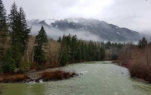 View of the Middle Fork Snoqualmie river (at approx 1500 cfs), from the Middle Fork Rd 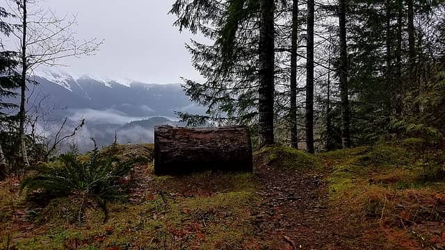 One of several places to stop and enjoy the view along the Granite Creek Connector trail. 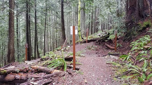 Junction of Granite Creek Connector and Granite Creek trail. You won't miss it! 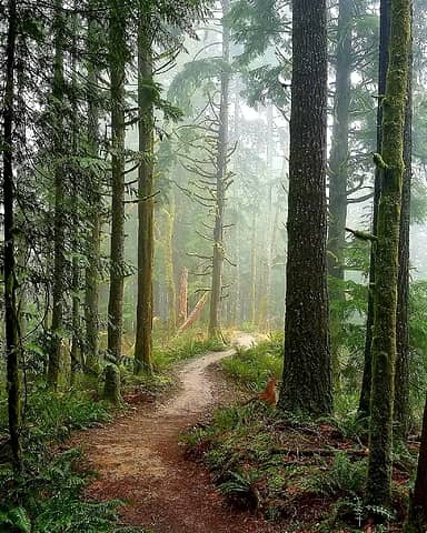 Descending the Granite Creek trail back to my car 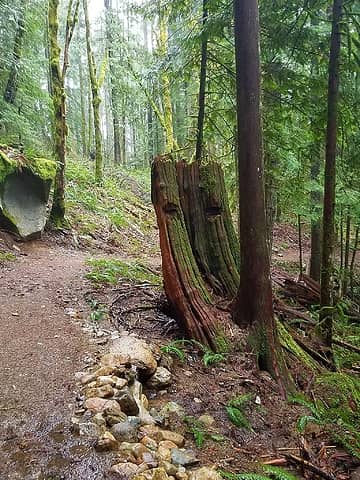 Stoned stump
|
| Back to top |
  
|
|
Nancyann
Member

Joined: 28 Jul 2013
Posts: 2318 | TRs | Pics
Location: Sultan Basin |
|
Nancyann
Member
|
Thu Jan 25, 2018 9:49 pm |
|
|
It's so great to see that you are starting to get back out on the trail again, jdk610! This looks like a pleasant loop trip, even on a rainy day. Your photo of the trail winding through the forest is really lovely!
I know what you mean about how breaking a bone can be very humbling. When I broke my femur a few years ago, I still had to somehow get out and feed my horses several times a day, pushing a walker. 
|
| Back to top |
|
|
puzzlr
Mid Fork Rocks

Joined: 13 Feb 2007
Posts: 7220 | TRs | Pics
Location: Stuck in the middle |
|
puzzlr
Mid Fork Rocks
|
Fri Jan 26, 2018 1:26 am |
|
|
| jdk610 wrote: | Descending the Granite Creek trail back to my car |
That's a spectacular photo. In thumbnail size it looks like a painting.
One of the original newsletters had this answer for "Why Pave The Road?"
| Quote: | Project objectives include:
- Improve road safety for current and future travelers
- Reduce road maintenance costs
- Provide safe access for recreational, emergency and law enforcement use that is consistent with Agency Plans
- Maintain and preserve the residential character of the couplet area
- Preserve the natural habitat and the visual and water quality
- Improve fish passage and reduce sedimentation of the river
- Minimize off road vehicle use within riparian and sensitive areas
- Complete improvements in a reasonable and cost effective manner.
- Improve the recreation infrastructure
|
Preserve the "water quality" might include silt, but what ran off the road is a tiny fraction of what the river erodes from clay banks all along the lower valley. The water doesn't have to get too high before it turns gray.
They don't list it as an objective because it's not, but besides the smooth ride, the most obvious benefit is bushes and trees along the road stay green all summer. Before they'd be covered in brown road dust by mid July.
|
| Back to top |
|
|
jdk610
Member
Joined: 21 Aug 2012
Posts: 330 | TRs | Pics
|
|
jdk610
Member
|
Fri Jan 26, 2018 8:37 am |
|
|
| Nancyann wrote: | | When I broke my femur a few years ago, I still had to somehow get out and feed my horses several times a day, pushing a walker. |
Damn, lady. That's tough! Your horses are lucky to have you.  puzzlr, thanks for posting that list. I was hoping you'd chime in!
I was thinking that "Improve fish passage and reduce sedimentation of the river" sums it up nicely.
Any idea if they plan to do usage studies of the area before/after paving the road? Would love to see how usage of the Middle Fork NRCA increases, and would be interested to see if surrounding trails (Si, e.g.) become less busy, maintain, or continue to increase...
puzzlr, thanks for posting that list. I was hoping you'd chime in!
I was thinking that "Improve fish passage and reduce sedimentation of the river" sums it up nicely.
Any idea if they plan to do usage studies of the area before/after paving the road? Would love to see how usage of the Middle Fork NRCA increases, and would be interested to see if surrounding trails (Si, e.g.) become less busy, maintain, or continue to increase...
|
| Back to top |
|
|
Sculpin
Member

Joined: 23 Apr 2015
Posts: 1384 | TRs | Pics
|
|
Sculpin
Member
|
Fri Jan 26, 2018 11:19 am |
|
|
This is the broken ankle you suffered on your way over Little Giant Pass. Good to hear that you are back on the trail!
Since I don't do snow sports anymore, I have just been staying home when it rains in the winter. But it always rains in the winter. And. Staying. Home. Is. Driving. Me. Nuts!
So maybe I should go check out this Granite Creek Trail.
Between every two pines is a doorway to the new world. - John Muir
Between every two pines is a doorway to the new world. - John Muir
|
| Back to top |
|
|
Windstorm
Member
Joined: 16 Dec 2014
Posts: 288 | TRs | Pics
|
| jdk610 wrote: | | I'm assuming they used pervious pavement or similar technology. |
I suspect they didn't use pervious pavement. It's more expensive and, depending on the product, isn't always suitable for heavy vehicles that can run on Forest Service roads. The plans call for "Superpave Pavement," but I don't know enough about asphalt to know exactly what that is.
Also, from the Environmental Assessment | Quote: | | "The preferred alternative would not create any new impervious surface as the existing graveled roadway is so compacted that it acts as impervious surface, and there would be a slight reduction (approximately 1.6 acres) in the roadway surface area." |
Since the old gravel road was already considered impervious, there's no real incentive to use pervious pavement because there's essentially no change in volume of runoff.
(Thanks puzzlr for posting useful documents on your website!)
|
| Back to top |
|
|
jdk610
Member
Joined: 21 Aug 2012
Posts: 330 | TRs | Pics
|
|
jdk610
Member
|
Fri Jan 26, 2018 1:24 pm |
|
|
Windstorm, great info, thanks.
Sculpin, yep, that's the ankle!
|
| Back to top |
|
|
|
|
You cannot post new topics in this forum
You cannot reply to topics in this forum
You cannot edit your posts in this forum
You cannot delete your posts in this forum
You cannot vote in polls in this forum
|
Disclosure: As an Amazon Associate NWHikers.net earns from qualifying purchases when you use our link(s). |


