| Previous :: Next Topic |
| Author |
Message |
Bootpathguy
Member


Joined: 18 Jun 2015
Posts: 1791 | TRs | Pics
Location: United States |
Northwest of Glacier Peak
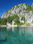
Anybody know the time span between this CalTopo ( Gmap4 ) map & this Google Earth Image
Interesting that CalTopo maps a portion of the exposed / open water of Milk Lake.
Is this typical?
Other examples?
Also, I'd love to see some recent images of this lake
Thanks
Experience is what'cha get, when you get what'cha don't want
Experience is what'cha get, when you get what'cha don't want
|
| Back to top |
  
|
|
Bootpathguy
Member
Joined: 18 Jun 2015
Posts: 1791 | TRs | Pics
Location: United States |
| Jeff wrote: | | I've slept on the colonial glacier in May and came back in July and it was a large lake. |
Ha! I was just looking at that. Unlike "Milk" it's a unnamed lake. I suppose it'll be named "Colonial Lake"
Thanks Jeff
Experience is what'cha get, when you get what'cha don't want
Experience is what'cha get, when you get what'cha don't want
|
| Back to top |
|
|
MyFootHurts
Huge Member

Joined: 22 Nov 2011
Posts: 912 | TRs | Pics
Location: Kekistan |
That's the google maps terrain layer. It does weird things like that around water and rivers.
It shows the Mid Fork as a a long narrow lake upstream of the Dingford trailhead for example.
Its just a mapping quirk. It has nothing to do with glacier melt and global warming if that's what you're getting at.
|
| Back to top |
|
|
iron
Member

Joined: 10 Aug 2008
Posts: 6392 | TRs | Pics
Location: southeast kootenays |
|
iron
Member
|
 Tue Jan 30, 2018 1:17 am |
|
|
i think there are other examples of this up by challenger or the chilliwacks. i forget. it's been awhile.
|
| Back to top |
|
|
Tom
Admin
Joined: 15 Dec 2001
Posts: 17854 | TRs | Pics
|
|
Tom
Admin
|
Tue Jan 30, 2018 1:55 am |
|
|
| Bootpathguy wrote: | | Also, I'd love to see some recent images of this lake |
8+ years ago
|
| Back to top |
|
|
Matt
Tea, Earl Grey, Hot

Joined: 30 Jan 2007
Posts: 4307 | TRs | Pics
Location: Shoreline |
|
Matt
Tea, Earl Grey, Hot
|
Tue Jan 30, 2018 9:16 am |
|
|
Very cool, Tom. I've looked at that lake on Google Earth and wanted to visit it sometime.
As beacons mountains burned at evening. J.R.R. Tolkien
As beacons mountains burned at evening. J.R.R. Tolkien
|
| Back to top |
|
|
JPH
Member

Joined: 14 Feb 2008
Posts: 808 | TRs | Pics
|
|
JPH
Member
|
Tue Jan 30, 2018 10:05 am |
|
|
| MyFootHurts wrote: | | Its just a mapping quirk. It has nothing to do with glacier melt and global warming if that's what you're getting at. |
Or its a copy of the USGS map that shows the Milk Lake Glacier from yesteryear. So maybe it does have to do with glacier melt
or maybe thats just a mapping quirk also
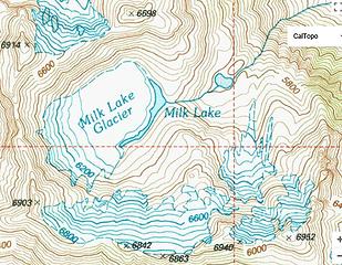 MLG
|
| Back to top |
|
|
Bootpathguy
Member
Joined: 18 Jun 2015
Posts: 1791 | TRs | Pics
Location: United States |
| Tom wrote: | | Bootpathguy wrote: | | Also, I'd love to see some recent images of this lake |
8+ years ago |
Thanks Tim. Wow. 8 years ago
ETA "Tom". Not Tim. Spell check likes Tim more than Tom. Alphabetical order I suppose

Experience is what'cha get, when you get what'cha don't want
Experience is what'cha get, when you get what'cha don't want
|
| Back to top |
|
|
MtnGoat
Member

Joined: 17 Dec 2001
Posts: 11992 | TRs | Pics
Location: Lyle, WA |
|
MtnGoat
Member
|
Tue Jan 30, 2018 7:16 pm |
|
|
Go on Google E and page through the pics at different dates. That will give you an idea of what's going on.
Diplomacy is the art of saying 'Nice doggie' until you can find a rock. - Will Rogers
Diplomacy is the art of saying 'Nice doggie' until you can find a rock. - Will Rogers
|
| Back to top |
|
|
borank
Lake dork
Joined: 16 Dec 2001
Posts: 640 | TRs | Pics
Location: Evert |
|
borank
Lake dork
|
Wed Jan 31, 2018 9:52 pm |
|
|
Milk Lk in '09
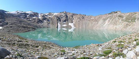 Milk Glacier Lake 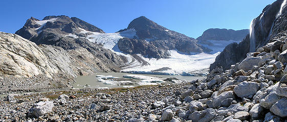 Colonial Lk
|
| Back to top |
|
|
iron
Member
Joined: 10 Aug 2008
Posts: 6392 | TRs | Pics
Location: southeast kootenays |
|
iron
Member
|
Wed Jan 31, 2018 10:44 pm |
|
|
| JPH wrote: | Or its a copy of the USGS map that shows the Milk Lake Glacier from yesteryear. So maybe it does have to do with glacier melt
or maybe thats just a mapping quirk also
MLG |
yeah, the areas around glacier peak seem to have these kind of mapping oddities. like when you look over at indian head peak or black mountain and you're like, hmm. unlikely to be permanent snowfields. maybe things did seem permanent when the maps were made.
|
| Back to top |
|
|
borank
Lake dork
Joined: 16 Dec 2001
Posts: 640 | TRs | Pics
Location: Evert |
|
borank
Lake dork
|
Thu Feb 01, 2018 12:54 am |
|
|
Check out John Scurlock's pics link from this earlier thread.
There's a pic of Colonial Lk from a decade ago that shows much less open water than my recent pic. There are dozens of lakes emerging from under the ice. Check out the White River Glacier lakes, or Borealis lake (N of Tricouni Pk).
Back in the mid '80s I spoke with a couple USGS field monitors at South Cascade Lk. Per their info, the terminus of S Cascade Glacier was at the outlet of the lake around 1910. By the mid 1960s the glacier had receded to a point exposing the entire lake. At the time of our conversation in the '80s the terminus was well up the hill above the lake and they said the glacier was receding 15 meters per year - which would amount to a quarter mile more between the '80s and now.
Most of the USGS quads are based of the 7.5' maps charted in the 60s, so yes, a few things have changed.
|
| Back to top |
|
|
rubywrangler
Member

Joined: 04 Aug 2015
Posts: 511 | TRs | Pics
|
|
| Back to top |
|
|
Sore Feet
Member

Joined: 16 Dec 2001
Posts: 6307 | TRs | Pics
Location: Out There, Somewhere |
| JPH wrote: | | Or its a copy of the USGS map that shows the Milk Lake Glacier from yesteryear. So maybe it does have to do with glacier melt
or maybe thats just a mapping quirk also
|
The Google Maps terrain data is likely derived from the USGS Topos, so considering that the most recent revision of the Lime Mountain quadrangle (1999) still shows the glacier and just the sliver of the lake, that's almost certainly why it appears as such on Google Maps.
|
| Back to top |
|
|
|
|


