| Previous :: Next Topic |
| Author |
Message |
Pribbs
Member


Joined: 13 Aug 2010
Posts: 179 | TRs | Pics
Location: Sammamish, WA |
|
Pribbs
Member
|
 Fri Mar 16, 2018 7:58 pm |
|
|
Here is the GPS track I refer to in my trip report. (On the way down I forgot to un-pause my watch after a break at the cabin and didn't resume it until about 500 feet below the cabin)
http://www.movescount.com/moves/move206288690
We started at the new Granite Lakes parking lot and the new trail that goes up from that lot. That trail is very nice with a wide smooth tread and some benches at some viewpoints. At 1.5 miles the trail meets the Granite Lakes trail. We hung a left and began to reach patchy snow at around 1900 feet just before the bridge over the creek. The snow began to get more consistent but in the morning it was firm enough to walk on with just boots. If you don't have mountaineering boots, microspikes could be nice to wear.
At 3100 feet 3.6 miles in we reached the Thompson Lake/Granite Lakes junction. On most days this is probably where snowshoes are needed. But we were able to go a bit higher in just boots. We stayed left at this junction and continued on to about 3500 feet/4 miles before we put on the snowshoes. At 4.8 miles/3950 feet we reached the un-signed junction where the trail to Thompson Lake went straight (right). But we continued up the road to the left higher up the mountain. We followed the road to 5.5 miles/4470 feet, and then we left the road and went straight up 1/4 a mile/500 feet of gain to the cabin. The cabin is pretty nice; well-built!
We pushed on up the ridge a short bit more to the summit of Thompson Point 6 miles from the TH, which is the SW peak of Revolution Peak.
From there, I stayed behind while the rest of my party continued on the ridge toward Revolution Peak. I returned to the cabin to wait for them but it didn't seem like long before they returned. Their progress was too slow on the ridge to Revolution and they turned around not too far from Thompson Point. So probably Revolution is a good spring ascent when snow is firmer and days are longer.
We descended the hill the same way we came up. The snow was softer so we kept snowshoes on until about 2500 feet in elevation on the way out. So about 4300 feet of gain and 12 1/4 miles round trip.
|
| Back to top |
  
|
|
Pribbs
Member
Joined: 13 Aug 2010
Posts: 179 | TRs | Pics
Location: Sammamish, WA |
|
Pribbs
Member
|
Sat Mar 17, 2018 4:12 pm |
|
|
Discover Pass. Nice new lot with restrooms and plenty of parking.
|
| Back to top |
|
|
Just_Some_Hiker
Member

Joined: 02 Jan 2013
Posts: 691 | TRs | Pics
Location: Snoqualmie, WA |
Is that person wearing a helmet?
|
| Back to top |
|
|
Pribbs
Member
Joined: 13 Aug 2010
Posts: 179 | TRs | Pics
Location: Sammamish, WA |
|
Pribbs
Member
|
Sat Mar 17, 2018 6:44 pm |
|
|
Yeah we took a short break at the cabin and some people put on helmets because we were expecting some steep drop offs on the ridge to Revolution.
|
| Back to top |
|
|
lopper
off-route

Joined: 22 Jan 2002
Posts: 845 | TRs | Pics
|
|
lopper
off-route
|
Sat Mar 17, 2018 8:14 pm |
|
|
Thanks for posting the images from your bluebird day up there.
We especially like the ones showing the back side of Kaleetan and Caroline...."nobody goes there".
Here is a beargrass-routfinding picture of son #1, taken during a 1985 Thompson incursion.
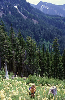 85Thomp2
|
| Back to top |
|
|
|
|


