| Previous :: Next Topic |
| Author |
Message |
christensent
Member


Joined: 05 Nov 2011
Posts: 658 | TRs | Pics
|
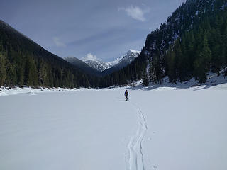
The plan: Leave the city at 6am, drive up the road, skin the easy 2.5 miles of forest to Slide Lake and up the valley, then go up the snowfields and summit mid afternoon.
What actually happened: Leave the city at 6am, hit snow on the road 13 miles before the trailhead and spend 3.5 hours driving the road (currently blocked to typical vehicles by deep snow, downed trees, washouts, and boulders) to within 1 mile of the trailhead where we just said screw it and started skinning. After going the last mile of road, we proceeded to skin at about 0.5-0.75MPH through horrific boulder fields and dense forest with a light 1-2 foot snowpack. Got to Slide Lake and proceeded another 0.75 miles on the other side. We realized we'd have to skin the entire exit and it'd probably take even longer than the approach. It was already 2:30pm at this point. With the fact that we wouldn't summit until probably 7pm at the earliest and left the overnight gear where we parked, we made the sad call to bail out before even getting near tree line. Not a single turn was had at any point on the trip despite skiing about 8 miles round trip.
So basically posting this TR since there's no reference online about what happens when you try to ski Slide Lake and beyond. Essentially, don't do it. There is a reason you've never seen a trip report for it.
 "How does it feel out there?" "Intellectually, it feels like I probably shouldn't be here"
Learning mountaineering: 10% technical knowledge, 90% learning how to eat
Learning mountaineering: 10% technical knowledge, 90% learning how to eat
|
| Back to top |
  
|
|
kitya
Fortune Cookie

Joined: 15 Mar 2010
Posts: 842 | TRs | Pics
Location: Duvall, WA |
|
kitya
Fortune Cookie
|
 Sun Apr 01, 2018 11:28 am |
|
|
Is it ilabot creek road? is it usually drivable in a normal car in summer?
|
| Back to top |
|
|
christensent
Member
Joined: 05 Nov 2011
Posts: 658 | TRs | Pics
|
| kitya wrote: | | Is it ilabot creek road? is it usually drivable in a normal car in summer? |
Yes that is the road. As far as I know, yes it is usually in good condition. It suffered a washout this winter which the forest service says can be navigated with a 4x4 using extreme caution, although it was under so much snow we didn't even see that washout described (I think I know where it was, the road got very narrow).
Learning mountaineering: 10% technical knowledge, 90% learning how to eat
Learning mountaineering: 10% technical knowledge, 90% learning how to eat
|
| Back to top |
|
|
wildernessed
viewbagger

Joined: 31 Oct 2004
Posts: 9275 | TRs | Pics
Location: Wenatchee |
 WOW that is an ambitious plan ! WOW that is an ambitious plan !
Living in the Anthropocene
Living in the Anthropocene
|
| Back to top |
|
|
Bootpathguy
Member

Joined: 18 Jun 2015
Posts: 1790 | TRs | Pics
Location: United States |
Cascade River Road approach not feasible this time of year?
Experience is what'cha get, when you get what'cha don't want
Experience is what'cha get, when you get what'cha don't want
|
| Back to top |
|
|
flatsqwerl
Member

Joined: 23 Feb 2010
Posts: 1049 | TRs | Pics
Location: tacoma |
this is a fun summer route.
|
| Back to top |
|
|
HermitThrush
Member
Joined: 14 Jan 2016
Posts: 384 | TRs | Pics
Location: Brainerd Lakes Area, MN |
Fun day with the jeep though I see. So it wasn't a total wash. Good times!
|
| Back to top |
|
|
fourteen410
Member

Joined: 23 May 2008
Posts: 2629 | TRs | Pics
|
| christensent wrote: | | It suffered a washout this winter |
Any idea how many miles in?
Slide Lake does look much nicer with snow.
|
| Back to top |
|
|
christensent
Member
Joined: 05 Nov 2011
Posts: 658 | TRs | Pics
|
| Bootpathguy wrote: | | Cascade River Road approach not feasible this time of year? |
Probably an easier drive. I think that route starts around 1200ft elevation which would require a significant amount of booting. I don't accept doing boot-based ski trips until late April at the earliest.
| fourteen410 wrote: | | christensent wrote: | | It suffered a washout this winter |
Any idea how many miles in?
Slide Lake does look much nicer with snow. |
Something very approximately along the lines of 11 miles in, 8 miles to go I forget the exact numbers.
Learning mountaineering: 10% technical knowledge, 90% learning how to eat
Learning mountaineering: 10% technical knowledge, 90% learning how to eat
|
| Back to top |
|
|
Schroder
Member

Joined: 26 Oct 2007
Posts: 6722 | TRs | Pics
Location: on the beach |
|
Schroder
Member
|
Sun Apr 01, 2018 3:33 pm |
|
|
Was your plan to ascend via the 4300' basin SW of Enjar Lake? I've come down that way in the summer and it's very steep. I imagine lots of avalanches on that side right now.
|
| Back to top |
|
|
christensent
Member
Joined: 05 Nov 2011
Posts: 658 | TRs | Pics
|
| Schroder wrote: | | Was your plan to ascend via the 4300' basin SW of Enjar Lake? I've come down that way in the summer and it's very steep. I imagine lots of avalanches on that side right now. |
Yes, although we were going to skirt out climbers right/west of the direct basin climb which I agree looks extremely steep and maybe cliffy. I believe bypassing out west is just a fairly gentle forest climbing although we didn't even get far enough to see it!
Learning mountaineering: 10% technical knowledge, 90% learning how to eat
Learning mountaineering: 10% technical knowledge, 90% learning how to eat
|
| Back to top |
|
|
Stefan-K
Member

Joined: 10 Aug 2009
Posts: 522 | TRs | Pics
Location: seattle |
|
Stefan-K
Member
|
Sun Apr 01, 2018 11:38 pm |
|
|
I'd say you did well for March 31st... you got pretty far.
ambitious for sure, even with this seasons meager low elev. snowpack... I can see the rationale...seems like after Dec. the lower elevation temps never stayed low for long.
It's funny tho when people shovel stats my way trying to convince me of some trip that'll have us all back in town by lets say 5, my mind glazes over like some unruly cascadian mountain range that could give a flying F about stats but is full of wild and unknown twists and turns... that's where the fun starts
|
| Back to top |
|
|
Schroder
Member
Joined: 26 Oct 2007
Posts: 6722 | TRs | Pics
Location: on the beach |
|
Schroder
Member
|
Mon Apr 02, 2018 7:41 am |
|
|
| christensent wrote: | | I believe bypassing out west is just a fairly gentle forest climbing |
It looks that way on the map but it isn't. It's probably pretty good when there's firm snow though. I came down it in August.
|
| Back to top |
|
|
cartman
Member
Joined: 20 Feb 2007
Posts: 2800 | TRs | Pics
Location: Fremont |
|
cartman
Member
|
Mon Apr 02, 2018 7:22 pm |
|
|
| christensent wrote: | | There is a reason you've never seen a trip report for it. |
Yep, I've been on routes with no TR for a certain time of year and found out the hard way just why that was. 
|
| Back to top |
|
|
mbravenboer
Member
Joined: 20 Oct 2013
Posts: 1422 | TRs | Pics
Location: Seattle |
That's a remarkable attempt  . .
|
| Back to top |
|
|
|
|


