| Previous :: Next Topic |
| Author |
Message |
kitya
Fortune Cookie


Joined: 15 Mar 2010
Posts: 842 | TRs | Pics
Location: Duvall, WA |
|
kitya
Fortune Cookie
|
 Mon May 28, 2018 7:40 am |
|
|
By now, I think, over the years I climbed most of the well-known Teanaway peaks (Jocker, Penguin, Jester, Riddler, Iron Bear, Navaho, Tarzan, Teanaway, Earl, Bills, Iron, Jolly, Ingalls, Fortune, Bean, Hawkins, Esmeralda, Yellow Hill, Elbow, Hex, probably more, it is hard to remember all the peaks!), so now it was time to scramble (pun intended) for some of the less obvious. On Saturday me and Cookie drove the NF-9703 forest road to its end and parked at the Miller/Iron Bear trailhead at a leisure late morning (8:30). The road has many smaller potholes, but is overall in one of the best conditions Ive ever seen it (or any forest road), helped by the really dry May. Miller Peak trail is also in great shape. There are a few creek crossings (nothing major, but feet can get wet) and a few downed trees and several very small patches of snow, but overall it is nice, smooth, no nonsense trail that quickly (but not too quickly) switchbacks to the summit of Miller Peak. I guess by now Miller peak season is over and we met no people on the trail. Miller Peak is not very high and doesnt have much of a view, except to the eastern foothills of Wenatchee mountains and Mount Rainier.
On a sunny day Teanaway open country can be a miserably hot place to be, but it can also be really windy and we had strong cold winds all day, making it much nicer to be outside.
From Miller summit we took off trail and followed the obvious bumpy ridge (also the border between Kittitas and Chelan counties) to another minor summit Freedom peak. There supposedly is (or was) a county line trail following the ridge, but we found no evidence of it. Regardless, it is mostly easy going, with sometimes patches of down trees, loose rock, a bit of snow and some rocky gendarmes to cross.
Freedom peak is also sometimes known as Little Navaho (see: https://www.summitpost.org/mountain/623906) and the best part of it is how pointy this little summit is. Unfortunately, rock is very loose and at this time there is already not enough snow to make a snowy ascent. It took a bit of time to find a way to scramble to the top, but nothing too bad.
After Freedom Peak we continued on the same county line ridge, dropping down to a col between Freedom and Navaho. One can perhaps traverse right from the col to the Three Brothers ridge, but traversing loose rock and some waterfalls looked sketchy and we climbed way up on Navaho ridge, before dropping down to the basin between Navaho and Three Brothers. This basin is still mostly snow covered and supports a family of ground squirrels.
From the basin it was again a quite tedious way up to Three Brothers west summit through more loose rock, some veggie belays and almost completely no snow.
Three Brothers is a curious mountain (see: https://www.summitpost.org/three-brothers/509019). It is actually third highest mountain in Teanaway range and first most prominent (1743 feet of prominence!). It is also the most remote of Teanaway area and thus quite rarely climbed. Even more annoyingly it not really one mountain, but three different quite isolated peaks. I was originally thinking about making it through all three (or two), which is possible, but adds quite a bit of time and effort. It is a true wilderness experience up there, but not much of a payoff, the views from Three Brothers are about the same or worse as from other closer peaks. Unless you are a botanist.
Anyway, since Im lazy, for now I went just a little bit past West Summit (passing the highest point of the mountain, so that technically I can say we were on it) and turned back to the Navaho-Three Brothers basin. From that basin I climbed another steep snowy ridge to Navaho peak.
We have been to both Navaho peak and Earl peak with Cookie in years before, so Navaho was not really that interesting to climb again (I usually try not to go to the same peak twice) but making it a loop is always more interesting that coming back the same way. Also helps keep dog entertained, otherwise she starts protesting and stalling once we come close to the car, if we take the same way down.
As one might expect we met first people of the day on Navaho peak and it was a zoo. Literally dozens of people, this time of year Navaho is a new mount Si. However by the time we got there it was already getting into afternoon and all these people camped around Navaho or in the Earl peak basin. We quickly passed them and the took now empty Stafford creek trail (best condition trail ever) down to the road. Great advantage of Stafford creek trail is also its gentle grade, which can be boring on the way up, but nice relief on the way down. There were many mosquitoes at the lower end of the trail due to proximity to water, so we participated somewhat involuntarily in a blood drive for them.
From the end of the trail it was a mile road walk to the car, making it a 22 miles round trip, with about 7450 feet gain over 4 Teanaway peaks longish, but not tiresome day of dog walking.
TL/DR: Forest road to Miller trailhead is in good condition, connecting Miller to Navaho via Freedom makes for a nice easy straightforward ridge walk/scramble, Three Brothers is a good side trip (for no reason, the views from Three Brothers west are not really better), but visiting each of Three Brothers will require several more hours. Little snow, but balsamroot, calypso orchids, paintbrushes and other flowers are abundant.
https://connect.garmin.com/modern/activity/2731202362
|
| Back to top |
  
|
|
RichP
Member

Joined: 13 Jul 2006
Posts: 5634 | TRs | Pics
Location: here |
|
RichP
Member
|
Mon May 28, 2018 8:52 am |
|
|
| kitya wrote: | | making it a 22 miles round trip, with about 7450 feet gain over 4 Teanaway peaks longish, but not tiresome day of dog walking. |
You are a strong dog walker. That's a fabulous loop.
|
| Back to top |
|
|
kitya
Fortune Cookie
Joined: 15 Mar 2010
Posts: 842 | TRs | Pics
Location: Duvall, WA |
|
kitya
Fortune Cookie
|
Mon May 28, 2018 10:13 am |
|
|
| RichP wrote: | | You are a strong dog walker. That's a fabulous loop. |
Dog does all the work  And she loves loops! And she loves loops!
|
| Back to top |
|
|
Walkinaround
Member

Joined: 11 Jun 2016
Posts: 66 | TRs | Pics
|
|
| Back to top |
|
|
kitya
Fortune Cookie
Joined: 15 Mar 2010
Posts: 842 | TRs | Pics
Location: Duvall, WA |
|
kitya
Fortune Cookie
|
Mon May 28, 2018 11:54 am |
|
|
| irierootsnw wrote: | | Funny, I did this exact same loop with a buddy yesterday, the same order of peaks and same traverse from miller to freedom and so on.
Also, we saw fresh bear tracks in the snow between miller and freedom along the ridge in the morning, looked to be less than 24hrs old otherwise I think they would have melted away with the heat. Ill try to post a pic later.
Was going to post a TR but you saved me the hassle! It is awesome out there right now. |
Wow! This is quite a coincidence! This loop is becoming popular! Lucky for you to see the bear prints! Please post photos of it (and more)!
Did you manage to get to the other Brother summits? I wonder if Middle or East Brother have different views!
|
| Back to top |
|
|
Walkinaround
Member
Joined: 11 Jun 2016
Posts: 66 | TRs | Pics
|
|
| Back to top |
|
|
JimK
Member

Joined: 07 Feb 2002
Posts: 5606 | TRs | Pics
Location: Ballard |
|
JimK
Member
|
Mon May 28, 2018 1:45 pm |
|
|
Adding to the coincidence, we were the three guys irierootsnw and his friend saw on the Navaho ridge above the saddle and again on the way down.
|
| Back to top |
|
|
Walkinaround
Member
Joined: 11 Jun 2016
Posts: 66 | TRs | Pics
|
|
| Back to top |
|
|
JimK
Member
Joined: 07 Feb 2002
Posts: 5606 | TRs | Pics
Location: Ballard |
|
JimK
Member
|
Mon May 28, 2018 2:00 pm |
|
|
You were talking to John who goes by Slood on this site. I was one of the others, the guy with the bright green backpack.
|
| Back to top |
|
|
Joey
verrry senior member

Joined: 05 Jun 2005
Posts: 2799 | TRs | Pics
Location: Redmond |
|
Joey
verrry senior member
|
Mon May 28, 2018 3:24 pm |
|
|
| kitya wrote: | | From Miller summit we took off trail and followed the obvious bumpy ridge (also the border between Kittitas and Chelan counties) to another minor summit Freedom peak. There supposedly is (or was) a county line trail following the ridge, but we found no evidence of it. |
For anyone that would like to find this portion of the County Line trail here is my 2008 TR. Note the link to a pdf map.
https://www.nwhikers.net/forums/viewtopic.php?t=7968513
|
| Back to top |
|
|
raising3hikers
Member
Joined: 21 Sep 2007
Posts: 2344 | TRs | Pics
Location: Edmonds, Wa |
nice job connecting all those peaks on the loop 
|
| Back to top |
|
|
kitya
Fortune Cookie
Joined: 15 Mar 2010
Posts: 842 | TRs | Pics
Location: Duvall, WA |
|
kitya
Fortune Cookie
|
Mon May 28, 2018 7:43 pm |
|
|
| irierootsnw wrote: | | Sorry they are upside down for some reason. Pretty small prints so maybe a small mother or cub? There was only this one set that I could see. It was hot out and the snow was slush already at this time, so these must have been quite recent, that morning or previous night?
Didnt go for the middle and east brother, although I went to the eastern edge of west brother to look at the route over and it looked do-able, but who knows what I couldnt see from that vantage point. |
Wow! Cool bear tracks! Must be recent, yeah! I also went to the eastern edge of west brother, but decided we don't have enough time to go further - I have another hungry pet waiting at home.
| Joey wrote: | | For anyone that would like to find this portion of the County Line trail here is my 2008 TR. Note the link to a pdf map. |
That is quite a detective work you did on the trail, Joey. Interesting! At some point on your photos the trail looks so faint, it is hard to tell if it is even official human trail or some wildlife trail instead. Deer make quite good trails too (but they usually don't lead anywhere nice). And your report was 10 years ago, will trail like this even survive for 10 more years to still be there now?
I also found a couple of white posts with concrete piers on the ridge between little and big navaho. They were not stashed though, just laying on the ridge in weird positions directly on some rock. Very weird posts.
There also was one hunting campsite with a huge pile of chopped wood covered by a tarp. Sad.
I've hiked other section of county line trail before (near Lake Ann/Esmeralda) and there the trail is much more of a real trail, very visible and looked maintained.
|
| Back to top |
|
|
Joey
verrry senior member
Joined: 05 Jun 2005
Posts: 2799 | TRs | Pics
Location: Redmond |
|
Joey
verrry senior member
|
Mon May 28, 2018 7:49 pm |
|
|
| kitya wrote: | | I also found a couple of white posts with concrete piers on the ridge between little and big navaho. They were not stashed though, just laying on the ridge in weird positions directly on some rock. Very weird posts. |
My theory is that there was a little-publicized border war between the two counties. Casualties were light. A truce was signed with a provision that posts were to be set to mark the line. Alas, at that point funding ran out.
|
| Back to top |
|
|
slood
Daffy Hiker

Joined: 28 Nov 2005
Posts: 235 | TRs | Pics
Location: Kent, WA |
|
slood
Daffy Hiker
|
Mon May 28, 2018 8:01 pm |
|
|
| JimK wrote: | | You were talking to John who goes by Slood on this site. I was one of the others, the guy with the bright green backpack. |
Jim, dont confuse the man. You werent carrying your bright green pack yesterday. 
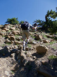 Gary & Jim climbing to the saddle between Navaho Peak and Little Navaho (aka Freedom Peak).
|
| Back to top |
|
|
kitya
Fortune Cookie
Joined: 15 Mar 2010
Posts: 842 | TRs | Pics
Location: Duvall, WA |
|
kitya
Fortune Cookie
|
Mon May 28, 2018 8:03 pm |
|
|
| Joey wrote: | | My theory is that there was a little-publicized border war between the two counties. Casualties were light. A truce was signed with a provision that posts were to be set to mark the line. Alas, at that point funding ran out |
Well I don't have any other theory and I like yours! However maybe a road was planned?
|
| Back to top |
|
|
|
|
You cannot post new topics in this forum
You cannot reply to topics in this forum
You cannot edit your posts in this forum
You cannot delete your posts in this forum
You cannot vote in polls in this forum
|
Disclosure: As an Amazon Associate NWHikers.net earns from qualifying purchases when you use our link(s). |


