| Previous :: Next Topic |
| Author |
Message |
rubywrangler
Member


Joined: 04 Aug 2015
Posts: 511 | TRs | Pics
|
A friend and I had planned a midweek trip to the Chelan Sawtooths but she couldn't escape from work. Not wanting to make the long drive from Seattle alone, but also not wanting to miss out on what looked to be a perfect forecast ahead of an impending storm, I headed for Clark Mountain. I had been thinking about doing a loop over Luahna to B. Butte but wasn't feeling that excited about a) lugging my full pack over two peaks or b) a solo, late season glacier crossing (with dog). I brought crampons & ice axe, intending to decide about the loop later based on timing and how the Pilz was looking. These ended up being dead weight.
Ruby and I arrived at the roadblock on White River Road at about 11:30am Tuesday. A quad pulled in right behind me, paused until I began to unpack, and then turned around and sped away. Maybe making sure I wasn't going to drive through the closure? Creepy, anyway. We hoofed it up the road, only to find a Ford Escape parked at the trailhead. Well, at least they had their NW forest pass on display(?) A USFS status report at the trailhead noted that the Boulder Pass trail has been brushed out all the way to the Napeequa this year.
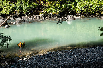
After stopping to ogle (me) and sip (Ruby) the river's milky blue-green water we continued up the White River trail. The river is so pretty, and the forest has lots of huge cedars and firs to keep you entertained. Including a bear-face tree. Lots of spiderwebs in the brushy sections though.
We made quick time to the Boulder Pass trail junction, where I proceeded to soak both shoes in a rock-hopping failure getting to lunch spot on a sunny gravel bar in the river.  After lunch, we started up the soft trail. More spiderwebs. The upper Boulder Creek crossing is easily passable but has deep, wet mud between branches of the creek. I slipped into this muck on the way down. Entering the basin the trail becomes brushy, and then intermittently muddy, as it heads toward the pass. After lunch, we started up the soft trail. More spiderwebs. The upper Boulder Creek crossing is easily passable but has deep, wet mud between branches of the creek. I slipped into this muck on the way down. Entering the basin the trail becomes brushy, and then intermittently muddy, as it heads toward the pass.
 white river 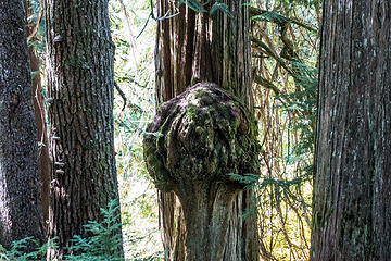 bear face tree 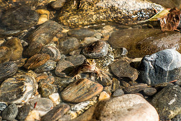 frog in the river 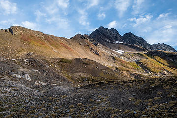 heading to the notch 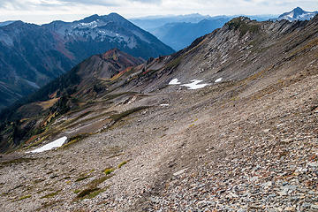 climbers path 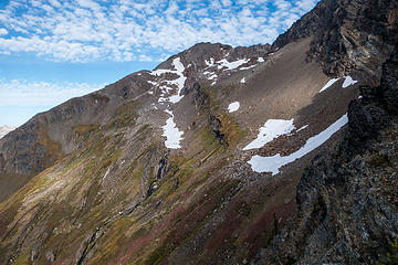 first summit sighting 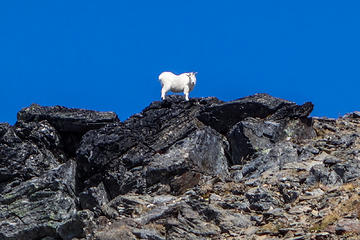 gatekeeper 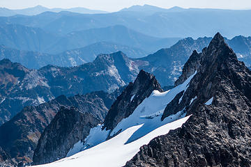 looking southwest from the summit 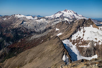 glacier + luahna 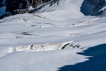 walrus 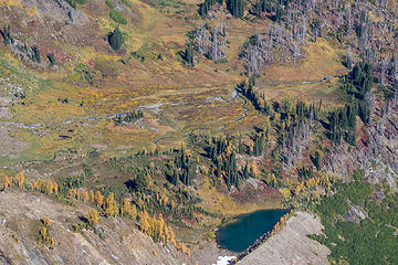 butte-eeful 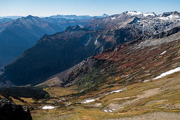 thunder basin 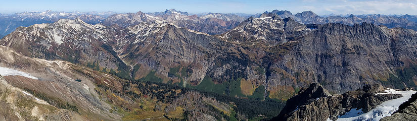 across the napeequa 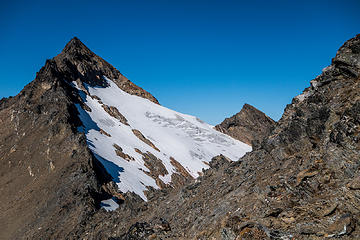 luahna from just below pt 7970 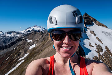 rare selfie 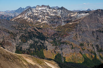 louis creek larches 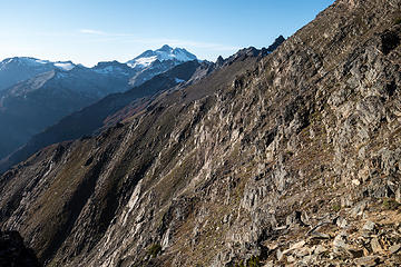 we crossed that? 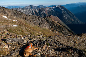 crash 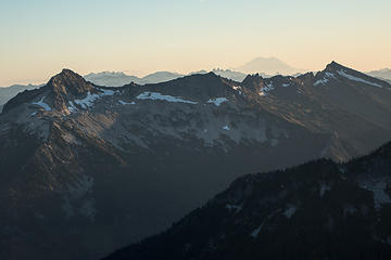 david, jonathan, whittier 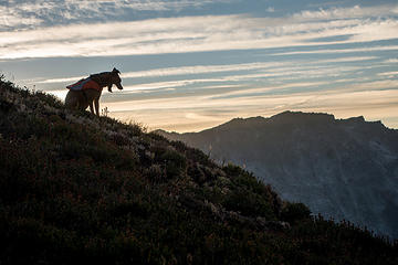 yawn 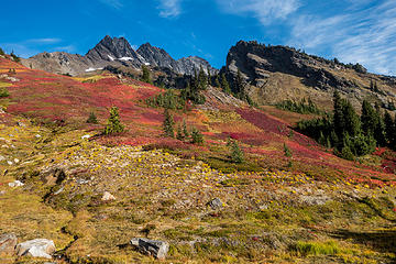 fall colors 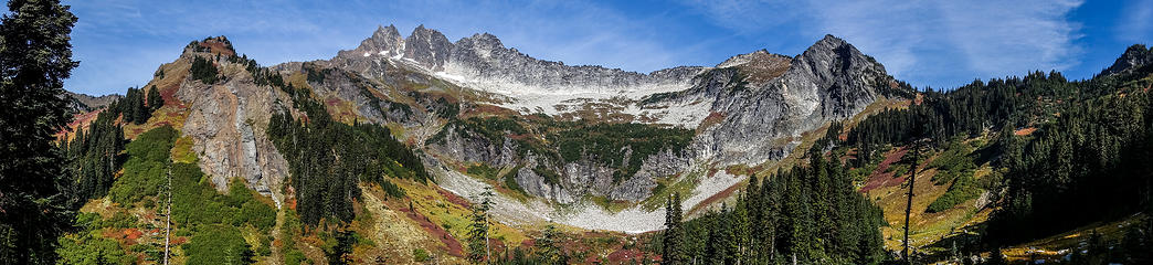 basin pano
|
| Back to top |
  
|
|
ale_capone
Member

Joined: 22 Sep 2009
Posts: 720 | TRs | Pics
|
Why not the Shepherds' trail? Had to be more then just one.
|
| Back to top |
|
|
Sculpin
Member

Joined: 23 Apr 2015
Posts: 1384 | TRs | Pics
|
|
Sculpin
Member
|
 Wed Oct 05, 2016 6:46 am |
|
|
| rubywrangler wrote: | fall colors |
This image pretty much sums up why some of us migrate to the high country in summer.
Excellent TR! I am so doing this next fall! 
Between every two pines is a doorway to the new world. - John Muir
Between every two pines is a doorway to the new world. - John Muir
|
| Back to top |
|
|
Gimpilator
infinity/21M

Joined: 12 Oct 2006
Posts: 1684 | TRs | Pics
Location: Edmonds, WA |
Nice solo trip! My group also hoped for Luahna and possibly Buck, but we only got Clark.
|
| Back to top |
|
|
Brushbuffalo
Member

Joined: 17 Sep 2015
Posts: 1887 | TRs | Pics
Location: there earlier, here now, somewhere later... Bellingham in between |
Your pictures are stunning, especially the extras on the link. Thanks!
Ruby is quite the climber. So are you!
Passing rocks and trees like they were standing still
Passing rocks and trees like they were standing still
|
| Back to top |
|
|
RichP
Member

Joined: 13 Jul 2006
Posts: 5634 | TRs | Pics
Location: here |
|
RichP
Member
|
Wed Oct 05, 2016 8:18 am |
|
|
Had you gone on to Luahna and dropped down to Thunder Ck on the way out, you would have experienced one of the most mind numbing bushwhacks the area has to offer.  Great photos
|
| Back to top |
|
|
silence
Member

Joined: 25 Apr 2005
Posts: 4420 | TRs | Pics
|
|
silence
Member
|
Wed Oct 05, 2016 8:34 am |
|
|
PHOTOS
FILMS
Keep a good head and always carry a light bulb. Bob Dylan
|
| Back to top |
|
|
Nancyann
Member
Joined: 28 Jul 2013
Posts: 2318 | TRs | Pics
Location: Sultan Basin |
|
Nancyann
Member
|
Wed Oct 05, 2016 9:18 am |
|
|
Great trip report and pictures, rubywrangler, including many beautiful ones on your Flickr link! Nice to see the fall colors still looking good up there.
I wonder if they will ever fix that road, the damage looks similar to the Tunnel Creek PCT access road, only you can still drive up that one.
|
| Back to top |
|
|
wildernessed
viewbagger

Joined: 31 Oct 2004
Posts: 9275 | TRs | Pics
Location: Wenatchee |
Living in the Anthropocene
Living in the Anthropocene
|
| Back to top |
|
|
ChinookPass
Member

Joined: 21 Aug 2009
Posts: 145 | TRs | Pics
|
Cool. Thanks for posting this.
|
| Back to top |
|
|
joker
seeker

Joined: 12 Aug 2006
Posts: 7953 | TRs | Pics
Location: state of confusion |
|
joker
seeker
|
Wed Oct 05, 2016 12:52 pm |
|
|
Great trip! Thanks for sharing. Ruby is a good sport!!
|
| Back to top |
|
|
Kenji
Member
Joined: 18 May 2010
Posts: 320 | TRs | Pics
Location: Seattle |
|
Kenji
Member
|
Wed Oct 05, 2016 1:40 pm |
|
|
Nice colors!! Thanks for TR
|
| Back to top |
|
|
iron
Member

Joined: 10 Aug 2008
Posts: 6392 | TRs | Pics
Location: southeast kootenays |
|
iron
Member
|
Wed Oct 05, 2016 2:41 pm |
|
|
| rubywrangler wrote: | | My willingness to get up at or before sunrise decreases proportionally with the morning temperature |
my partners generally have issues with this 
|
| Back to top |
|
|
Brushbuffalo
Member
Joined: 17 Sep 2015
Posts: 1887 | TRs | Pics
Location: there earlier, here now, somewhere later... Bellingham in between |
| iron wrote: | | rubywrangler wrote: | | My willingness to get up at or before sunrise decreases proportionally with the morning temperature |
my partners generally have issues with this |
True in the Cascades. SO TRUE in Alaska....makes me cold just thinking about it!
Brrrr!
Passing rocks and trees like they were standing still
Passing rocks and trees like they were standing still
|
| Back to top |
|
|
Distel32
Member
Joined: 03 Jun 2014
Posts: 961 | TRs | Pics
Location: Edmonds, WA |
|
Distel32
Member
|
Wed Oct 05, 2016 3:24 pm |
|
|
|
| Back to top |
|
|
|
|


