| Previous :: Next Topic |
| Author |
Message |
Jordan
y


Joined: 22 Feb 2008
Posts: 561 | TRs | Pics
Location: shoreline |
|
Jordan
y
|
 Mon Aug 13, 2018 9:50 pm |
|
|
| Alpine Pedestrian wrote: | | There's a long list of trail closures effective 8/12/18 - Buck Creek, Chiwawa River, Phelps Creek, Leroy Basin, Carne Mtn, Little Giant, Rock Creek, Old Gib, Estes Butte, Basalt Peak,and Schafer Lake with a requirement to Exit Immediately. Here's the link to the notice:
https://www.facebook.com/cougarcreekfire/posts/1885655285064469 |
Damn.
|
| Back to top |
  
|
|
Jordan
y
Joined: 22 Feb 2008
Posts: 561 | TRs | Pics
Location: shoreline |
|
Jordan
y
|
Mon Aug 13, 2018 10:39 pm |
|
|
Isn't there a way into buck creek pass from the Suiattle river?
|
| Back to top |
|
|
AlpineRose
Member

Joined: 08 May 2012
Posts: 1953 | TRs | Pics
|
I don't think you understand, Jordan. The "exit immediately" means the areas listed, regardless of how you enter.
|
| Back to top |
|
|
Jordan
y
Joined: 22 Feb 2008
Posts: 561 | TRs | Pics
Location: shoreline |
|
Jordan
y
|
Tue Aug 14, 2018 1:50 am |
|
|
| AlpineRose wrote: | | I don't think you understand, Jordan. The "exit immediately" means the areas listed, regardless of how you enter. |
Actually, Alpine Rose, you dont quite understand how the trail systems work or where I am going. Doesnt say anything about suiattle river trail, buck creek PASS trail, miners ridge trail, PCT south of suiattle pass, flower dome trail, or liberty cap trail. So tell me again AR what dont I understand about it? Obviously you have not been to this area before. Wasnt planning on coming in the suiattle side then dropping way into the phelps creek or buck creek basins. You know there are other trails up there. Duh
|
| Back to top |
|
|
treeswarper
Alleged Sockpuppet!
Joined: 25 Dec 2006
Posts: 11279 | TRs | Pics
Location: Don't move here |
|
treeswarper
Alleged Sockpuppet!
|
Tue Aug 14, 2018 5:58 am |
|
|
Another smoke reported last night in the Okanogan Highlands. We shall see if all the work pays off. That area has been logged and has had prescribed fire here and there so may not be as volatile as wilderness areas.
What's especially fun about sock puppets is that you can make each one unique and individual, so that they each have special characters. And they don't have to be humananimals and aliens are great possibilities
What's especially fun about sock puppets is that you can make each one unique and individual, so that they each have special characters. And they don't have to be humananimals and aliens are great possibilities
|
| Back to top |
|
|
Jake Robinson
Member
Joined: 02 Aug 2016
Posts: 521 | TRs | Pics
|
Not a great day to be in the Enchantments
|
| Back to top |
|
|
Nancyann
Member
Joined: 28 Jul 2013
Posts: 2319 | TRs | Pics
Location: Sultan Basin |
|
Nancyann
Member
|
Tue Aug 14, 2018 1:31 pm |
|
|
Here is a picture from yesterday at about 4700 feet on a ridge above the Mountain Loop Highway. This was taken looking west. The haze was so thick looking east into the Monte Cristo Range and north towards the Glacier Peak Wilderness that I didnt even bother taking a photo. We could barely see the outline of the closest peak to us. We are postponing a planned backpacking trip until we can actually see where we are going.
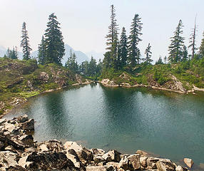 8/13/18
|
| Back to top |
|
|
coldrain108
Thundering Herd

Joined: 05 Aug 2010
Posts: 1858 | TRs | Pics
Location: somewhere over the rainbow |
Hurricane Ridge?  
Since I have no expectations of forgiveness, I don't do it in the first place. That loop hole needs to be closed to everyone.
Since I have no expectations of forgiveness, I don't do it in the first place. That loop hole needs to be closed to everyone.
|
| Back to top |
|
|
ranger rock
One of the boys

Joined: 14 Dec 2011
Posts: 2550 | TRs | Pics
|
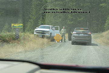
I took a media tour of the Maple Fire yesterday. Fire is 35% contained and is moving slowly. It is burning in the underbrush. Fire will be contained to North, South and West. Fire will be allowed to burn to the east until it goes out.
Lena Lake trail, Hamma Hamma Cabin and all the campgrounds should be safe. Even Jefferson Ridge does not look too bad at the moment.. just a few patches of torched trees.
They have done some backburning and were able to save most of the trees and burn just the underbrush in the back burn area. A sprinkler line has been set up above and to the South of Elk Lakes.
http://mosswalks.blogspot.com/2018/08/maple-fire-media-tour.html More pictures on my blog.
 All rights reserved. Media outlets may purchase these. 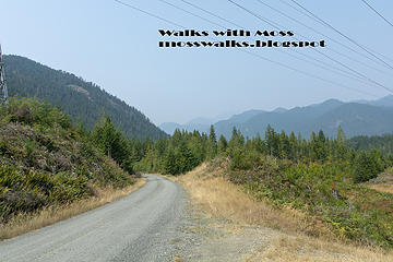 All rights reserved. Media outlets may purchase these.  All rights reserved. Media outlets may purchase these. 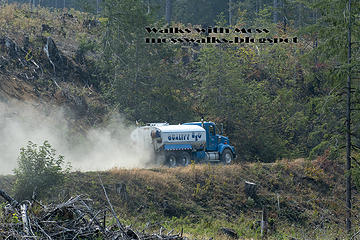 All rights reserved. Media outlets may purchase these. 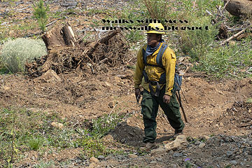 All rights reserved. Media outlets may purchase these. 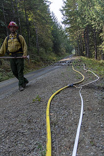 All rights reserved. Media outlets may purchase these. 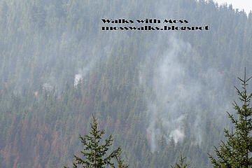 All rights reserved. Media outlets may purchase these. 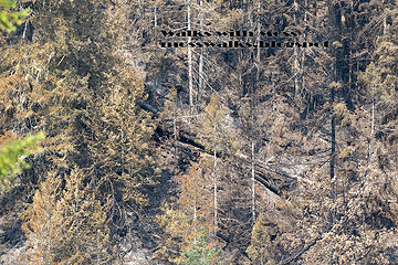 All rights reserved. Media outlets may purchase these. 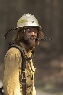 All rights reserved. Media outlets may purchase these. 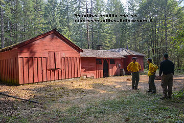 All rights reserved. Media outlets may purchase these. 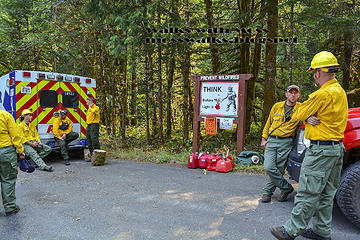 All rights reserved. Media outlets may purchase these.
|
| Back to top |
|
|
MtnGoat
Member

Joined: 17 Dec 2001
Posts: 11992 | TRs | Pics
Location: Lyle, WA |
|
MtnGoat
Member
|
Thu Aug 16, 2018 4:28 pm |
|
|
Diplomacy is the art of saying 'Nice doggie' until you can find a rock. - Will Rogers
Diplomacy is the art of saying 'Nice doggie' until you can find a rock. - Will Rogers
|
| Back to top |
|
|
wildernessed
viewbagger

Joined: 31 Oct 2004
Posts: 9275 | TRs | Pics
Location: Wenatchee |
Dry tstorms passed through the Wenatchee area this a.m. not enough to wake me up but it woke up my wife and got the dogs fired up. On radar heading NNE through Chelan - Pateros.
Living in the Anthropocene
Living in the Anthropocene
|
| Back to top |
|
|
Joey
verrry senior member

Joined: 05 Jun 2005
Posts: 2799 | TRs | Pics
Location: Redmond |
|
Joey
verrry senior member
|
Fri Aug 17, 2018 8:30 am |
|
|
|
| Back to top |
|
|
gb
Member
Joined: 01 Jul 2010
Posts: 6310 | TRs | Pics
|
|
gb
Member
|
Fri Aug 17, 2018 8:37 am |
|
|
| wildernessed wrote: | | Dry tstorms passed through the Wenatchee area this a.m. not enough to wake me up but it woke up my wife and got the dogs fired up. On radar heading NNE through Chelan - Pateros. |
Modeling and NWS thought that such activity would be just in NE Oregon and perhaps in the Blue Mountains. I could see this essentially a train of showers and thunderstorms moving up along the Sierra Crest yesterday morning and then into Eastern Oregon late in the day. God, I hope it didn't hit the Cascades.
Up to 48 hour view of recent lightning
It seems certain there would be a multitude of new starts in Eastern Northeastern Oregon and likely the Blues. Nevada also got lit up yesterday.
There is another risk Monday-Tuesday-Wednesday as another more or less dry trough is likely to develop just SW of Astoria. It could rain at the end of the period but by then it would be too late to stop any fires that might develop.
|
| Back to top |
|
|
MtnGoat
Member
Joined: 17 Dec 2001
Posts: 11992 | TRs | Pics
Location: Lyle, WA |
|
MtnGoat
Member
|
Fri Aug 17, 2018 8:53 am |
|
|
this sucks. We were planning on spending Labor day up on the Entiat/Chumstick ridge area
Diplomacy is the art of saying 'Nice doggie' until you can find a rock. - Will Rogers
Diplomacy is the art of saying 'Nice doggie' until you can find a rock. - Will Rogers
|
| Back to top |
|
|
mbravenboer
Member
Joined: 20 Oct 2013
Posts: 1422 | TRs | Pics
Location: Seattle |
|
| Back to top |
|
|
|
|


