| Previous :: Next Topic |
| Author |
Message |
User-Name
Member


Joined: 10 Aug 2010
Posts: 312 | TRs | Pics
Location: bellevue |
Hooked up with Erick on Mercer Island at 6:30 AM yesterday, but driving to the North Cascades takes a couple hours and multiple coffee stops, so our boots didn't touch trail till 10:08 AM, not exactly an 'alpine start,' but the day would be a long one and I kinda remembered stuffing a lamp in the pack...heh. To the pix....
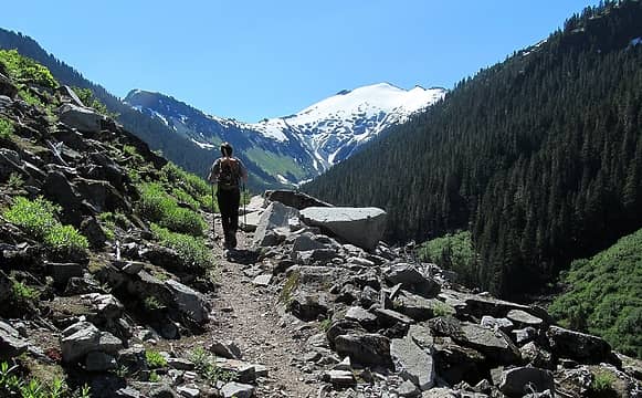 The approach trail to Hannigan Pass is open, airy, and keeps the first target in view--very nice. 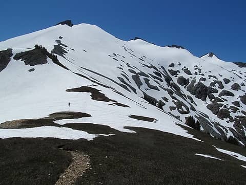 Snow was fantastic all day. Erick, starting up. If you zoom and squint, you can just make out the party of two near the summit ridge. 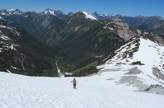 Spectacular, relaxed booting, with our approach valley below. 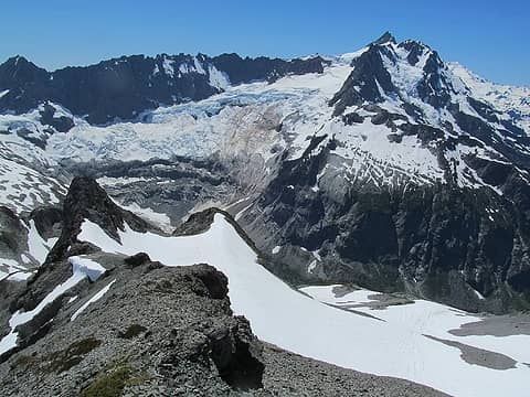 Shuksan from Ruth. 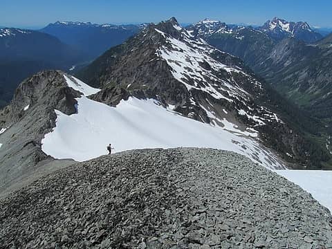 Dropping down from Ruth, enjoying the well-groomed scree ski runs. 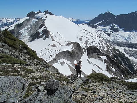 Target #2: The N.W. Summit of Icy, the larger central tower. 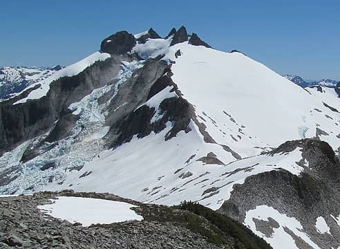 Icy's magnificent Spillway Glacier. 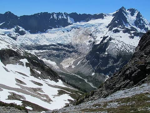 Dropping down toward the connecting ridge, the valley below Shuksan opens up. 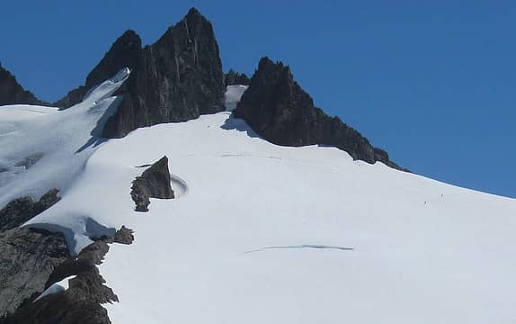 A party of two--the only others we encountered on Icy--descends the route, staying high above the large, mid-slope crevasse. We chatted briefly, getting some useful info for the summit climb. 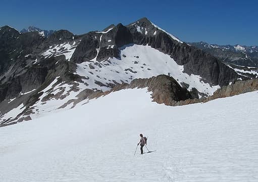 Glancing back at Ruth as we start up the glacier toward Icy. 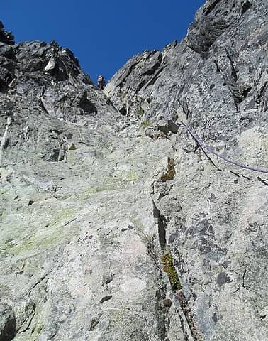 The final gully, rated class 4 by the guidebook, was a slabby, sandy, exposed affair, so we decided to pitch it out with my half-rope and a few runners from the bottom of Erick's pack. 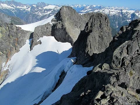 The complex summit, from near the top of the N.W. tower. 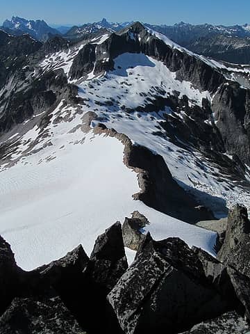 Ruth, from the summit of Icy. 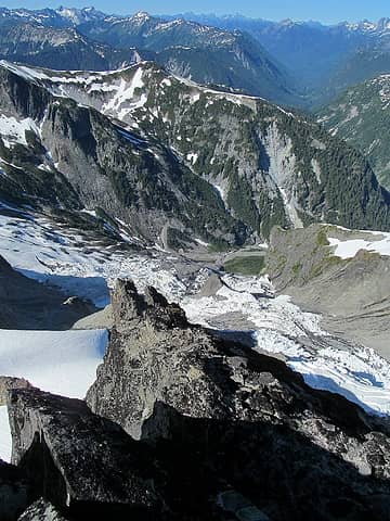 Spillway Glacier and beyond. 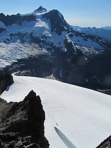 That gaper crevasse, as seen from the top. 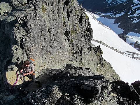 Since we had the gear, and since a downclimb from the summit would have taken at least a couple years off our lives, we set up for a series of quick abseils using existing rap stations. 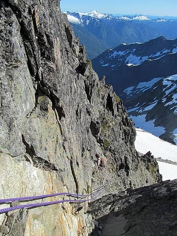 The rope really sped things up. 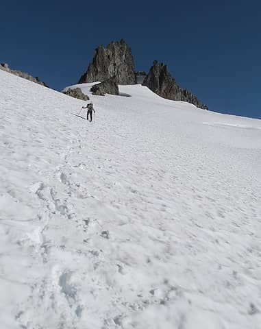 Dropping from the towers for the sprint back up to Ruth. 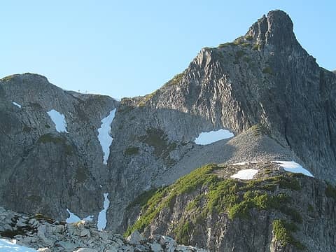 A party of campers hanging out at the col below Ruth. The return up to the col is a relaxed scramble just right of the snow finger. 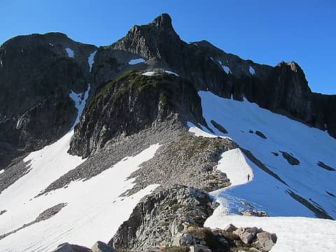 Erick, cruising up to the start of the col scramble--this bit goes quick. 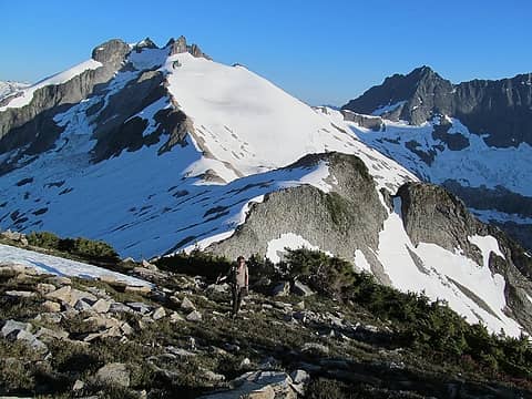 Lengthening shadows kept us moving quickly. 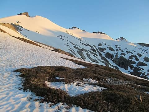 We avoided re-climbing Ruth, moving instead through a gap in rocks just above the col, then traversing back to pick up our original ascent tracks. Once back down, the only remaining problem is a horrible, deteriorating root ladder that takes you back to the approach trail. We were on lamp for the last few miles to finish up a FANTASTIC day in the hills!
|
| Back to top |
  
|
|
neek
Member

Joined: 12 Sep 2011
Posts: 2337 | TRs | Pics
Location: Seattle, WA |
|
neek
Member
|
 Sun Jul 15, 2018 12:22 pm |
|
|
you've been talking about this one for a while, great to see it happen!
|
| Back to top |
|
|
radka
Member

Joined: 28 Mar 2010
Posts: 57 | TRs | Pics
|
|
radka
Member
|
Sun Jul 15, 2018 6:53 pm |
|
|
|
| Back to top |
|
|
User-Name
Member
Joined: 10 Aug 2010
Posts: 312 | TRs | Pics
Location: bellevue |
|
| Back to top |
|
|
iron
Member

Joined: 10 Aug 2008
Posts: 6392 | TRs | Pics
Location: southeast kootenays |
|
iron
Member
|
Sun Jul 15, 2018 10:15 pm |
|
|
|
| Back to top |
|
|
Brushbuffalo
Member

Joined: 17 Sep 2015
Posts: 1887 | TRs | Pics
Location: there earlier, here now, somewhere later... Bellingham in between |
That's a lot of ground to cover in a day. I have only climbed Icy from Nooksack Cirque, a stiff haul up from that deep hole and nowhere nearly as scenic as your and Radka's pictures show the traverse to be.
| User-Name wrote: | Icy's magnificent Spillway Glacier. |
The Spillway Glacier has shrunk considerably in the past few decades. I wish I could easily post a picture of what it looked like in the late 1960s, but all I have are 35 mm slides that haven't been scanned. It filled the slope where it now wastes away.
Passing rocks and trees like they were standing still
Passing rocks and trees like they were standing still
|
| Back to top |
|
|
Distel32
Member
Joined: 03 Jun 2014
Posts: 961 | TRs | Pics
Location: Edmonds, WA |
|
Distel32
Member
|
Mon Jul 16, 2018 7:24 am |
|
|
|
| Back to top |
|
|
User-Name
Member
Joined: 10 Aug 2010
Posts: 312 | TRs | Pics
Location: bellevue |
| iron wrote: | | no true summit of icy? |
Yeah, I think the book said one of the other towers was a few feet higher but tougher to access, so the cost / benefit ratio favored the N.W. summit. To be honest, we didn't expect even the "standard" route to be as sketchy as we found it, and I was glad we happened to bring enough gear to protect it.
|
| Back to top |
|
|
User-Name
Member
Joined: 10 Aug 2010
Posts: 312 | TRs | Pics
Location: bellevue |
| Brushbuffalo wrote: | | The Spillway Glacier has shrunk considerably in the past few decades. .... It filled the slope where it now wastes away. |
That would be really cool to see. It was a jaw-dropper on Saturday; I can only imagine what it must have been like half a century ago. Thanks! 
|
| Back to top |
|
|
DIYSteve
seeking hygge

Joined: 06 Mar 2007
Posts: 12655 | TRs | Pics
Location: here now |
|
DIYSteve
seeking hygge
|
Mon Jul 16, 2018 9:08 am |
|
|
It's a cool route. AFAICT most parties tag only the NW peak, which is depicted 10 feet lower on the map. When we did it 10-12 years ago, a Mountaineers group tagged to NW peak and called it good.
I would rate the rock low 5th with a few mid-5th moves.
I'm surprised to hear there was a rap runner bird nest. We saw no slings. We set up our own rap stations (working cooperatively with the Mounties, which may have been a Mounties no no?)
|
| Back to top |
|
|
iron
Member
Joined: 10 Aug 2008
Posts: 6392 | TRs | Pics
Location: southeast kootenays |
|
iron
Member
|
Mon Jul 16, 2018 9:15 am |
|
|
| User-Name wrote: | | iron wrote: | | no true summit of icy? |
Yeah, I think the book said one of the other towers was a few feet higher but tougher to access, so the cost / benefit ratio favored the N.W. summit. To be honest, we didn't expect even the "standard" route to be as sketchy as we found it, and I was glad we happened to bring enough gear to protect it. |
true summit is in a different location:
https://www.nwhikers.net/forums/viewtopic.php?t=8012882
http://www.peakbagger.com/peak.aspx?pid=1629
only about .15 miles away as the crow flies, but about 1/2 mile each way to walk to it.
|
| Back to top |
|
|
radka
Member
Joined: 28 Mar 2010
Posts: 57 | TRs | Pics
|
|
radka
Member
|
Mon Jul 16, 2018 11:36 am |
|
|
|
| Back to top |
|
|
|
|


