| Previous :: Next Topic |
| Author |
Message |
kitya
Fortune Cookie


Joined: 15 Mar 2010
Posts: 842 | TRs | Pics
Location: Duvall, WA |
|
kitya
Fortune Cookie
|
 Tue Aug 14, 2018 3:28 pm |
|
|
Unlike the name suggests Mac Peak is not next to PC Peak. A few days ago I learned about Deception Lakes and FR 6830 from an excellent trip report by Nancyann (https://www.nwhikers.net/forums/viewtopic.php?t=8027879). Finding a short day trip idea from the west side of US HWY 2 always makes me really happy, since this area is closest to my home and involves less driving. After doing some more research about possible nice places to visit that might not be too crowded, I stumbled on Mac Peak, which was an easy choice, because Mac Peak is the highest mountain in the general vicinity. Since we finally had a weekend with the break from horrible summer weather we have, I was feeling extremely happy heading up HWY 2 in what seems like a first heavy rain in a long time.
Gradually my hopes for a short drive were dashed. Drive on FR 6830 is not for the faint of heart. This road is insanely long (20+ miles) and one is guaranteed to question his/her sanity on this road. For all 20 miles this road is marked by exactly one sign a tiny metal sign 6830 that strategically placed as so to be invisible from the turn off (the road is the second unsigned turn off from Beckler river road). And that is it. The road is not particularly bad. Any car can make it. There are potholes here and there, but mostly the surface is good. It is just long. Very-very long. Gradually it gets narrower. You will pass many equally unsigned stub roads branching left and right. They are easy to dismiss as they are usually very overgrown. Finally, at about mile 6 or 7, I got to an unsigned intersection where both roads look almost equally major. In fact, the right road (6830) looks less maintained there. The right roads goes down, while more inviting (but wrong) road goes up to Sawyer Mountain. I head down and driving conditions also went down from there.
After the intersection 6830 gets more and more narrow and more and more and more overgrown. It is not possible not to scratch paint on brush. Potholes start to look deeper. There is grass in the middle that looks way taller than average sedan clearance. And in 15 miles like that there is hardly any place to turn around, so getting to meet oncoming traffic would not be fun. Well, since it was rainy and I was driving through a dense cloud I couldnt see more than 5 feet in front of the car anyway. I didnt see a wooden cross that some reports indicate exist on this road. But I saw a grouse, so that was cool.
Finally, I got to a very-very sad looking trailhead with really no parking except squeezing by road side for maybe 1-2 cars, and, even more sadly, clearly human poop next to the register.
Mosquitoes attacked us as soon as we got out of the car, so I quickly (in fact as quick as I could) dropped down Fisher creek trail to the Deception creek trail intersection and then realized that I forgot my map back in the car, so I had to hike back up again and grab the map.
The forest there is beautiful. Big trees. Lots of water. It was very wet with the rain and all. Quite cold (I was happy I brought layer). A bit overgrown trail in places, but mostly perfect conditions.
Lots of mushrooms. Many different boletes. Many corals. I found my very first Chicken of the woods mushroom and it was so beautiful, I couldnt dare to cut it and bring it home to eat 😊I did eat a couple of nicer boletes though. Mirabilis was really tasty and not wormy, which is very rare this time of year. Some woody chanterelles and many other mushrooms I dont really know.
Fording Fisher creek was easy, though right next to it we stumbled into a couple of campers with a couple of very angry big off-leash dogs who immediately attacked Cookie. Thankfully I was able to grab her up in time and protect her. This place seems to be popular with campers for some reason, as we also so them on the way back at the same spot. But we didnt see any other people anywhere else.
Deception creek ford was a bit wetter, but also not hard. A couple of miles on deception creek trail to the PCT intersection are very pleasant and mellow.
Once we got off trail, as previous trip reports indicate, we immediately found the first tarn. Unfortunately, we also found what appears to be mosquito headquarters of North America. Lets just say it is very clear that mosquitoes are not endangered species. Cookie was attacked so much, she freaked out and started trying to pull and run in random directions hoping to shake of the bugs. In all the confusion we never found the animal trail (maybe we used a wrong gully or path is no longer there) and instead we pushed through very steep, very wet and very eye pocking brush up, using veggie belays. Finally, we got to a nice open meadow and an avalanche gully that we took up to the ridge.
After the rain, this place is beautiful. Lake Clarice across the valley looks amazing. There are several smaller lakes and tarns on the sides. I couldnt take many photos because of mosquitoes and rain though. Through the clouds it is hard to say where Mount Daniel glaciers end and clouds begin. It looks really big and mystical. Cathedral Rock looks like a magical hat.
Mosquitoes continued to follow us like a black cloud. Lots of very wet marmots up there. They look beautiful too, but oh my, I felt so sad for them. They sure have patience of a Buddha to be able to just sit on the rock with biting mosquitoes biting them everywhere, including eyes. Natural world is so amazing, but also so cruel. I wanted to ask all mosquitoes to come bite me instead. At least I only have to endure it for a day. Marmot spends months with them.
When you startle a marmot taking a shower this happens:
Lots of marmot, deer or maybe goat poop everywhere and even a bear took a dump right before the summit.
There is a bunch of snow on steep sides, especially near to the gully that leads to Square lake (that is not square by hourglass shaped) and lake Wolverine. These lakes and Talus lake are very pretty too. Unfortunately, no snow on the route. I would not recommend this route for any sunny day no place to cool down.
I found the register on the summit. Usually I dont care about registers, but this one is special, very nwhikeresque. I could recognize many names of people I have never met, but certainly read trip reports from. Looks like since 2012 still only 4 pages are used.
2012 - 2 visits.
So first visit recorded is Sept 8 2012 Eric Willhite (http://www.willhiteweb.com/) I guess he installed the register and made it popular. Sept 12 2012 BarbE and Ragman climbed it too.
2013 - 4 visits.
Next year was 2013 very popular, Bryan K and Adam Walker (Gimpilator) and Natasha Walkev climbed it on Jul 09 2013. Jul 16, Aug 31, and September 20th 2013 visits completed the list for 2013, for the whooping 4 groups reaching the summit.
2014 - 2 visits.
Jul 11 and Oct 19 2014 are the two groups who reached summit in 2014.
2015 - 2 visits.
RichP and Ortiz? reached summit on July 3, 2015. Mike Ferguson on Aug 8 (Or 9?) or 2015. I guess it was a multi-day trip where he forgot the track of time.
2016 - 1 visit.
John Porter (onehikeaweek) on 7 aug 206.
2017 - 0 visits.
I found from the reports that mbravenboer was probably there in winter maybe?
2018 - 3 visits (including mine).
I wonder if 2018 will turn out the most popular year yet.
We walked down a different route on the ridge and then down to Deception lakes completing it in a loop. This was a long way of steep wet slippery rocks, insane angry bugs and pocky brush. Finally between two Deception lakes we forded another creek and found the horse camp and a nice trail back.
Interestingly, after the mosquito headquarters in the bushes, it feels like Deception lakes and PCT doesnt have bugs at all. That seems strange. If I was a bug, I would go to the trail and bite hikers and not marmots. Seems more fair, and also hikers have more blood. Dont know why mosquitoes dont do that.
The trip ended up being 17.41 mi and 5,148 ft gain, but this includes an extra 500 feet and a mile when I was going back to the car to pick up the map.
https://connect.garmin.com/modern/activity/2928317500
Very pretty place. But drive back and the traffic are horrible. I don't know who the senator is and I don't endorse him, and I also don't know from this poster all over hwy 2 if he is for or against traffic (or maybe if he is not re-elected he personally will try to make traffic even worse?), but I think it is a brave idea to strongly associate your name with traffic jams. I applaud that.
|
| Back to top |
  
|
|
olderthanIusedtobe
Member

Joined: 05 Sep 2011
Posts: 7709 | TRs | Pics
Location: Shoreline |
Great series of marmot shots!  They do look a bit bedraggled. I admire those critters. Spend almost half their life asleep buried under big piles of snow. Have to eat like crazy when they are awake, but still find plenty of time for lounging around, and a bit of play fighting. They do look a bit bedraggled. I admire those critters. Spend almost half their life asleep buried under big piles of snow. Have to eat like crazy when they are awake, but still find plenty of time for lounging around, and a bit of play fighting.
|
| Back to top |
|
|
kitya
Fortune Cookie
Joined: 15 Mar 2010
Posts: 842 | TRs | Pics
Location: Duvall, WA |
|
kitya
Fortune Cookie
|
Tue Aug 14, 2018 5:03 pm |
|
|
| Eric Willhite wrote: | | So just before I placed that register, the previous register disappeared. I guess it was a NWHikers "traveling summit register" and nobody knows what happened to it. It died on Mac Peak, placed in Aug 2011 This Trip Report. When I posted my report the following summer, people were asking about it and I nor anyone after me found anything up there. |
Well, thank you for the current register. It is a fun one. Also thank you for the excellent directions on your webpage and a map - I would not have found this peak without these.
|
| Back to top |
|
|
kitya
Fortune Cookie
Joined: 15 Mar 2010
Posts: 842 | TRs | Pics
Location: Duvall, WA |
|
kitya
Fortune Cookie
|
Tue Aug 14, 2018 5:04 pm |
|
|
| olderthanIusedtobe wrote: | | Great series of marmot shots! They do look a bit bedraggled. I admire those critters. Spend almost half their life asleep buried under big piles of snow. Have to eat like crazy when they are awake, but still find plenty of time for lounging around, and a bit of play fighting. |
They are amazing. Also very wet and bitten by bugs. Poor marmots! Also, as with all other rodents, they are very genetically and evolutionary close to us!
|
| Back to top |
|
|
Nancyann
Member
Joined: 28 Jul 2013
Posts: 2319 | TRs | Pics
Location: Sultan Basin |
|
Nancyann
Member
|
Tue Aug 14, 2018 5:35 pm |
|
|
Great marmot photos, Kitya! It sounds like your experience on F.S. Road 6830 was similar to ours. After all, I did describe it as a very long and paint-scratchy road.  Here is a photo of the cross you were talking about.
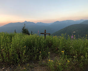 Memorial site
|
| Back to top |
|
|
kitya
Fortune Cookie
Joined: 15 Mar 2010
Posts: 842 | TRs | Pics
Location: Duvall, WA |
|
kitya
Fortune Cookie
|
Tue Aug 14, 2018 5:38 pm |
|
|
| Nancyann wrote: | | Great marmot photos, Kitya! It sounds like your experience on F.S. Road 6830 was similar to ours. After all, I did describe it as a very long and paint-scratchy road. |
Yep! I remember that! Sadly I didn't take your advice too seriously. I underestimated how long and paint-scratchy it is. It took me 1+ hours to drive this forest road each way. I definitely do not wish to drive it again any time soon 
|
| Back to top |
|
|
Nancyann
Member
Joined: 28 Jul 2013
Posts: 2319 | TRs | Pics
Location: Sultan Basin |
|
Nancyann
Member
|
Tue Aug 14, 2018 5:42 pm |
|
|
One hour is how long it took us as well. My biggest worry was that we would meet another vehicle along the way, and have to back down the road for several miles.
|
| Back to top |
|
|
kitya
Fortune Cookie
Joined: 15 Mar 2010
Posts: 842 | TRs | Pics
Location: Duvall, WA |
|
kitya
Fortune Cookie
|
Tue Aug 14, 2018 5:48 pm |
|
|
| Nancyann wrote: | | One hour is how long it took us as well. My biggest worry was that we would meet another vehicle along the way, and have to back down the road for several miles. |
Yeah, that would be bad! I was driving in a complete fog, so I was also thinking that if oncoming car happens, I might need to get a cross for myself too 
|
| Back to top |
|
|
Mike Collins
Member
Joined: 18 Dec 2001
Posts: 3097 | TRs | Pics
|
It is fitting to have brought your dog with you on an ascent of Mac Peak. The peak is one of two Cascade mountains that I know of which are named after dogs. Albert "Hal" Sylvester's dog was named "Mac" and this peak honors him. Does anyone know one other WA peak named after a dog? Hint...It was Lage Wernstedt's dog.
Double hint...The peak Wernstedt named after his dog is close to the peak he named to honor his wife.
|
| Back to top |
|
|
Bootpathguy
Member
Joined: 18 Jun 2015
Posts: 1791 | TRs | Pics
Location: United States |
Nice to see those 2 lakes from a different vantage
Experience is what'cha get, when you get what'cha don't want
Experience is what'cha get, when you get what'cha don't want
|
| Back to top |
|
|
Jake Robinson
Member
Joined: 02 Aug 2016
Posts: 521 | TRs | Pics
|
Mike, I was just reading about Mr. Wernstedt and I believe the mountain you're referring to is located near Castle Peak, but I won't give it away so others can guess.
He's an interesting figure in the early exploration of the Cascades and not many people seem to know about him. His bio is worth a read.
|
| Back to top |
|
|
kitya
Fortune Cookie
Joined: 15 Mar 2010
Posts: 842 | TRs | Pics
Location: Duvall, WA |
|
kitya
Fortune Cookie
|
Tue Aug 14, 2018 7:05 pm |
|
|
| Mike Collins wrote: | | It is fitting to have brought your dog with you on an ascent of Mac Peak. The peak is one of two Cascade mountains that I know of which are named after dogs. Albert "Hal" Sylvester's dog was named "Mac" and this peak honors him. Does anyone know one other WA peak named after a dog? Hint...It was Lage Wernstedt's dog.
Double hint...The peak Wernstedt named after his dog is close to the peak he named to honor his wife. |
I certainly didn't bring my dog. She brought me. I'm just an attachment to her leash!
Hm... Redwick on https://www.summitpost.org/mac-peak/544268 writes:
"According to local library archives, Mac Peak was named by Forest Ranger John S. Brender in honor of the first name of an early employee of the Okanogan National Forest. However, some reports claim Mac Peak was named by A.H. Sylvester, first Forest Supervisor of Wenatchee National Forest, in honor of a dog named Mac but those reports have been unverified."
According to wikipedia https://en.wikipedia.org/wiki/Albert_Hale_Sylvester A.H. Sylvester named another peak after his dog, Klone peak - "He even named Klone Peak after his dog Klone.[6]". So unless he had more than one dog, I don't get how both Mac and Klone could be named by him after a dog.
Sadly I first time heard about Lage Wernstedt from you. But I cheated a little bit and found out this is Jocker mountain in north cascades you are talking about.
|
| Back to top |
|
|
kitya
Fortune Cookie
Joined: 15 Mar 2010
Posts: 842 | TRs | Pics
Location: Duvall, WA |
|
kitya
Fortune Cookie
|
Tue Aug 14, 2018 7:07 pm |
|
|
| Bootpathguy wrote: | | Nice to see those 2 lakes from a different vantage |
What is your vantage Lee?
|
| Back to top |
|
|
mbravenboer
Member
Joined: 20 Oct 2013
Posts: 1422 | TRs | Pics
Location: Seattle |
|
| Back to top |
|
|
kitya
Fortune Cookie
Joined: 15 Mar 2010
Posts: 842 | TRs | Pics
Location: Duvall, WA |
|
kitya
Fortune Cookie
|
Tue Aug 14, 2018 8:47 pm |
|
|
Well you sure had fun anyway and it was beautiful. Summit is not a big deal. Oh, how I miss winter already!!!
|
| Back to top |
|
|
|
|
You cannot post new topics in this forum
You cannot reply to topics in this forum
You cannot edit your posts in this forum
You cannot delete your posts in this forum
You cannot vote in polls in this forum
|
Disclosure: As an Amazon Associate NWHikers.net earns from qualifying purchases when you use our link(s). |


