| Previous :: Next Topic |
| Author |
Message |
KarlK
Member


Joined: 18 Jun 2009
Posts: 584 | TRs | Pics
|
|
KarlK
Member
|
 Fri Aug 10, 2018 1:00 pm |
|
|
I had expected to get a wildland fire assignment through Team Rubicon's Wildland Fire Program by August 5, but hadn't yet gotten one. That put the kibosh on my ability to commit to the mandatory 14+ day obligation. Maybe they think that at age 66 I'm too old a duck.
Hah! I did the 36 hour wildland fire school in Boise in early May, and to qualify, you've gotta do a 3 mile pack test with a 45# pack in 45 minutes or less. I was the first among the ~80 participants across the finish line at 37:14, and would have done it in 35 min or so, but they won't let you jog; averaging 4.8 mph while walking with a 45# pack is super inefficient. In any event, I guess that all Cody Dispatch knows is that I did qualify. And am 66.
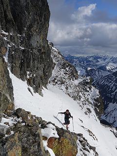
So, I decided to have another go at Mt. Prophet in the N Cascades starting on Aug 6. Doug McKeever, Chuck Spiekerman and I had previously made an attempt on June 19-21 (https://www.nwhikers.net/forums/viewtopic.php?t=8027408), but were thwarted by a route finding misunderstanding (which turned out to be a good thing owing to the onset of a severe T-storm).
I opted for the SE ridge route, which starts from where the Big Beaver trail crosses 39 mile creek at ~1800' some 12.6 miles from the Ross Lake trailhead. It was notably hot, but I comfortably though sweatily averaged just over 3mph with my "old school" too-much-stuff pack.
The initial third or so of the SE ridge involves steep but fairly open forest, and featured one particuarly annoying section of packed dirt at ~3800' that obliged the use of my ice axe pick per Chouinard's "Piolet Juron Terre" technique.
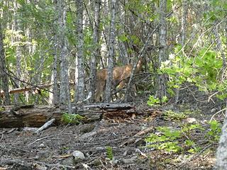 Deer at ~2500' on SE ridge, Aug 6 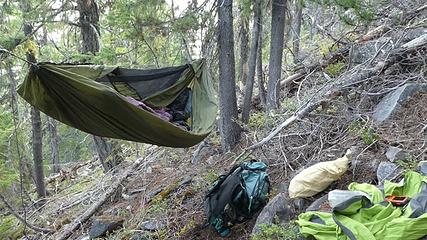 Camp @ 4120', Aug 6, 2018 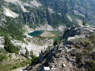 Maise Lake, 5450', Aug 7, 2018 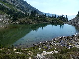 Maise Lake. It's got fish! 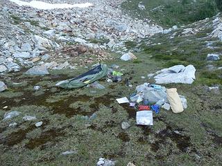 Bivvy @ 6200', Aug 7, 2018 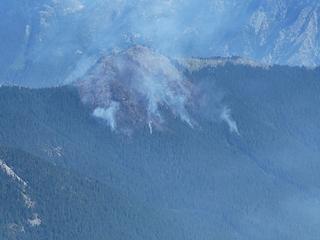 Smokes in Arctic Creek, Aug 8 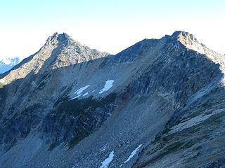 Prophet (L), False Prophet, Aug 8 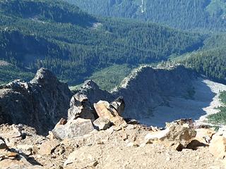 Jacob's Ladder, Aug 8, 2018 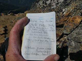 Fay Pullen Abides 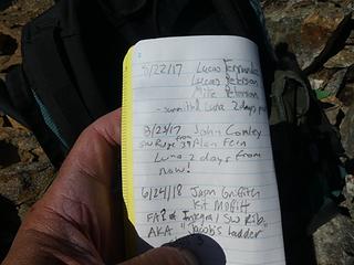 P 2 of register 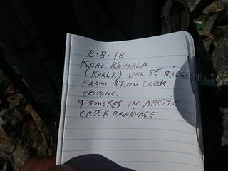 7th recorded ascent since Fay P's in 2014 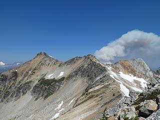 Growing plume from Arctic Cr. fire, Aug 8, 2018 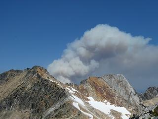 Plume zoom 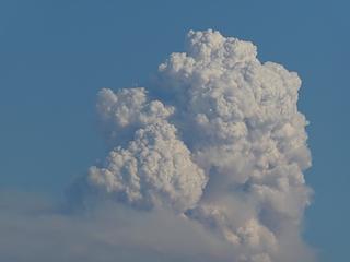 Pyrocumulus Zoomulus, Aug 8
|
| Back to top |
  
|
|
flatsqwerl
Member
Joined: 23 Feb 2010
Posts: 1051 | TRs | Pics
Location: tacoma |
Although I am not hammock camper, I love the way you can hang from trees comfortably on crappy non-flat terrain!
|
| Back to top |
|
|
Josh Journey
a.k.a Josh Lewis
Joined: 01 Nov 2007
Posts: 4836 | TRs | Pics
|
Got to see the Arctic Creek fire just two miles or less away from the Redoubt col. Saw it double in size within a short time span. What I don't understand is how it's 4 separate fires right next to each other. Lightning striking the ridge over and over? Also good to know the big flammagenitus cloud is near the head of the Twisp river.
Also alarming was the fact that there were two other fires nearby, one near Chilliwhack lake that is gaining momentum.
|
| Back to top |
|
|
KarlK
Member
Joined: 18 Jun 2009
Posts: 584 | TRs | Pics
|
|
KarlK
Member
|
Fri Aug 10, 2018 5:55 pm |
|
|
Josh, I'm no expert, but fire school 101 did make it clear that fire behavior is complex and treacherous stuff. You can get spotting, which is when an initial fire causes new starts via sparks or embers carried aloft.
Also, I think that a "single" lightning strike can impact multiple points on the ground owing to bifurcation of the electrical path.
In addition, burning debris often rolls down hill and causes new starts.
One of the instructors talked at some length about new starts caused by "flaming bunnies." Maybe there's a "flaming marmots" analog to this.
My chief Team Rubicon mentor, Dick Schaertl, a seasoned wildland firefighter and woodsman among many other things, talked of flaming elk and deer bounding out of a fire and starting new ones. Dick's the guy who talked me into going to fire school.
The flaming critter factor is likely far afield from the cause of the multiple Arctic Creek fires, but does emphasize the multiplicity of ways that fires can spread.
|
| Back to top |
|
|
KarlK
Member
Joined: 18 Jun 2009
Posts: 584 | TRs | Pics
|
|
KarlK
Member
|
Fri Aug 10, 2018 6:15 pm |
|
|
|
| Back to top |
|
|
HitTheTrail
Member

Joined: 30 Oct 2007
Posts: 5460 | TRs | Pics
Location: 509 |
Interesting TR 
| flatsqwerl wrote: | | Although I am not hammock camper, I love the way you can hang from trees comfortably on crappy non-flat terrain! |
That is one of the big advantages of a hammock, and did you notice he used it on the ground when above treeline also. In my opinion they offer more options than a tent. Keeping TR comments positive is a good thing, but that looks like a scary flat hang angle to me. The flatter the angle gets from 30* the more stress you are putting on your suspension. At some level of flat the whole thing can fail and you are on your butt. If you are very high off the ground or above rocks that is not a good thing!
|
| Back to top |
|
|
KarlK
Member
Joined: 18 Jun 2009
Posts: 584 | TRs | Pics
|
|
KarlK
Member
|
Fri Aug 10, 2018 7:20 pm |
|
|
HitTheTrail -- You're correct about that and I'm well aware of the physics here (same stuff as with climbing anchors). The picture makes it look like the angle from horizontal was quite shallow, but that's because my Warbonnet Blackbird has a ridge line cord that keeps the netting properly positioned and when the hammock is properly set up, that ridge line is horizontal. If you look closely, you'll see that the far suspension point is well off the ground, and likewise with the other tree; the loaded hang angle was just fine. Been sleeping in hammocks since, oh about 1968, and definitely take the angle of the dangle into account.
|
| Back to top |
|
|
Josh Journey
a.k.a Josh Lewis
Joined: 01 Nov 2007
Posts: 4836 | TRs | Pics
|
Thanks Karl for the explanation. That's a substantial distance between each fire, but the rolling theory is my favorite one. Regarding 1968; used a 1968 Quad topo to get back to the Redoubt col which was superior to most modern beta.
As for the incoming storm according to NOAA regarding Darrington:
| Quote: | | A chance of showers, then showers and possibly a thunderstorm after 11am. High near 71. Light and variable wind. Chance of precipitation is 80%. New rainfall amounts between a quarter and half of an inch possible. |
Precipitation fluctuates based on location, however it seems possible the rain may alleviate some of the incoming damage. May some of the fires get put out from this.
|
| Back to top |
|
|
KarlK
Member
Joined: 18 Jun 2009
Posts: 584 | TRs | Pics
|
|
KarlK
Member
|
Fri Aug 10, 2018 10:59 pm |
|
|
Josh, I sure agree about the superiority of the older quad topos for navigation. One of my (many) pet peeves is how crappy the compressed green trails maps are for off-trail navigation, or for that matter, for an awful lot of on-trail navigation given how many trails that are listed as "maintained" are actually in lousy shape or worse, especially in the Pasayten and Glacier Peak areas. I basically consider green trails maps to be a menace except for the standard hikes close to Seattle.
As to the potential for T-storms and rain, I hope you're correct, but my attention is on the dramatic temperature change in the forecast, which, if the onshore flow happens rapidly could well increase convective available potential energy (CAPE) to levels that strongly favor T-storms development. We shall see. Fuel moisture is at record and near-record lows. It doesn't take much to set this stuff off, and once off, it can go to the races exponentially.
|
| Back to top |
|
|
DIYSteve
seeking hygge

Joined: 06 Mar 2007
Posts: 12655 | TRs | Pics
Location: here now |
|
DIYSteve
seeking hygge
|
Sat Aug 11, 2018 11:06 am |
|
|
Cool You did that solo? That's some lonely terrain.
| KarlK wrote: | | and featured one particuarly annoying section of packed dirt at ~3800' that obliged the use of my ice axe pick per Chouinard's "Piolet Juron Terre" technique. |
I recall that patch. We did the SE ridge a few years ago, intending to climb Prophet, but got hammered by a huge storm with lightning and crazy winds, pinning us down in our tents for 36 hours in a high cirque a bit NE of Pt. 6690. We were forced to retreat when the rain backed off to steady but not torrential. We saw lots of bear scat on the SE ridge route.
|
| Back to top |
|
|
KarlK
Member
Joined: 18 Jun 2009
Posts: 584 | TRs | Pics
|
|
KarlK
Member
|
Sat Aug 11, 2018 11:49 am |
|
|
DIYSteve, yup did it solo, and lonely it is. Save for two deer about 1000 or 1500' up the ridge, I saw no other ground-bound wildlife; no marmots or other small mammals. Only saw a few birds.
And not for a lack of looking -- I spent a fair amount of time scanning for wildlife with my Zeiss 8x30 binos and nada. The place seemed eerily vacant and made me acutely aware of how puny I really am. That's a good thing to periodically remind yourself of.
I think I camped in the same place you mentioned; very flat, very comfy, just padded around in stocking feet. The right hand dot in the picture is where I camped; the left hand dot is where Doug & Chuck and I stopped earlier this year. Only about 0.6 miles apart. Point 6690 the intersection of the three ridge crests up and to the left of right-hand dot.
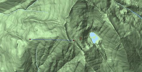 Screen Shot 2018-08-10 at 9.47.53 PM
|
| Back to top |
|
|
Brian Curtis
Trail Blazer/HiLaker

Joined: 16 Dec 2001
Posts: 1696 | TRs | Pics
Location: Silverdale, WA |
FWIW, that lake is generally called Firn Lake.
that elitist from silverdale wanted to tell me that all carnes are bad--Studebaker Hoch
that elitist from silverdale wanted to tell me that all carnes are bad--Studebaker Hoch
|
| Back to top |
|
|
KarlK
Member
Joined: 18 Jun 2009
Posts: 584 | TRs | Pics
|
|
KarlK
Member
|
Sun Aug 12, 2018 7:50 pm |
|
|
Thanks Brian, I'm happy to know this. It seem highly unlikely that Maisy (whose name I spelled incorrectly) will put up any objections.
|
| Back to top |
|
|
awilsondc
Member

Joined: 03 Apr 2016
Posts: 1324 | TRs | Pics
|
|
| Back to top |
|
|
KarlK
Member
Joined: 18 Jun 2009
Posts: 584 | TRs | Pics
|
|
KarlK
Member
|
Sat Aug 25, 2018 10:09 pm |
|
|
The fire I got pictures of in Arctic Creek is now named the 'Arctic Jim' fire and has grown to 642 acres as of August 24.
The last fire in Arctic Creek (2012 I think I remember) was the 'Arctic Dan' fire, named for the lookout on Desolation peak.
So I imagine that the current lookout is a fellow named Jim.
|
| Back to top |
|
|
|
|
You cannot post new topics in this forum
You cannot reply to topics in this forum
You cannot edit your posts in this forum
You cannot delete your posts in this forum
You cannot vote in polls in this forum
|
Disclosure: As an Amazon Associate NWHikers.net earns from qualifying purchases when you use our link(s). |


 That's hard to do without jogging... I mean really hard. I hope I can be anywhere near that fast when I reach that age. Super impressive! Fun read too. Keep it up!