| Previous :: Next Topic |
| Author |
Message |
Brushbuffalo
Member


Joined: 17 Sep 2015
Posts: 1887 | TRs | Pics
Location: there earlier, here now, somewhere later... Bellingham in between |
Update added for August 22, 2020 ( scroll down)
On August 17 the smoke had cleared quite a bit, so I did a nice little hike/jog in my "backyard," the North Fork of the Nooksack area: up the popular Excelsior Pass trail, east along the scenic above-timberline High Divide trail to Welcome Pass, then down the steep Welcome Pass trail to its trailhead, continuing down along a gravel road to my stashed bike, and finally 5 miles west on the highway to the starting point and the truck.
The flowers are past their prime, with only some blooming paintbrush, mountain valerian, and arnica close to Welcome Pass. The peak of berries and the fall color are a month away. However, there were very few bugs, a first for this summer, with only a few annoying horse flies to pester me. There is water on both ends of this route, but along High Divide on this late season there is running water only in a large flat meadow at the halfway point (you have to search for it) and 1/4 mile west of Welcome Pass in a shallow clear pond. All three trails are in excellent condition, with a total of five small trees down, all easy step-overs.
I encountered five people in three different groups as I descended Welcome Pass trail. Although they were climbing up in mid-day, the continual forest all the way to the pass makes for a shaded hike even on this south-facing steep mountainside. Now that the Shuksan Lake trail is abandoned, this is the steepest trail in the Mount Baker district. Starting from the trailhead and climbing, the initial half mile or so is deceptively mild, being on an old logging road. But then the work starts! When descending, it is so steep that although I tried to run down it like I have on past occasions, the necessity of braking results in more of an awkward trot than a run......I swear this trail is steeper than it was when I first did it 51 years ago!  About the sackungen! (sackung is singular, sackungen pl.). About 1/2 mile west of Welcome Pass on High Divide, as the trail descends and turns slightly more eastward, you will notice that the trail follows a linear trench that holds the contour for about 1/4 mile. There is a treed lip on the downhill side of the trench that rises 15 or 20' above the trench base. I recall this from previous trips on this route but this time figured out that this trench is a sackung, about which I have reported from at least one previous trip elsewhere. This is a feature associated with massive downslope movement, although in this case it seems to be inactive and probably has been for many centuries. When returning home I looked at Google Earth imagery and it is apparent that the trail follows one of several parallel sackungen in this vicinity, suggesting a large prehistoric landslide had occurred. Sure enough, the geologic map of the Mount Baker area shows a landslide here, so it was known and mapped by earlier investigators (our geology with the USGS in 1967 was concerned mainly with bedrock geology, not surficial materials, so we either missed it or passed over its significance in the larger geologic picture).
The trail distance is about 11.9 miles and it took a little less than five hours. Although I don't precisely quantify such things (pardon), there is about 5,000 or 6,000' of climbing. I had stashed a bike so that I could pedal the Mount Baker Highway back to my truck rather than running the busy paved highway (recommended if you don't do a car ferry).
By the way, the Excelsior Pass trailhead is right on the highway, while the Welcome Pass trailhead is at the end of a mildly brushy gravel road with a couple of deep holes....negotiable with most 2-wd cars unless they are low clearance (there were two trucks and one Subaru there when I came down, but not a single Prius!)
About the sackungen! (sackung is singular, sackungen pl.). About 1/2 mile west of Welcome Pass on High Divide, as the trail descends and turns slightly more eastward, you will notice that the trail follows a linear trench that holds the contour for about 1/4 mile. There is a treed lip on the downhill side of the trench that rises 15 or 20' above the trench base. I recall this from previous trips on this route but this time figured out that this trench is a sackung, about which I have reported from at least one previous trip elsewhere. This is a feature associated with massive downslope movement, although in this case it seems to be inactive and probably has been for many centuries. When returning home I looked at Google Earth imagery and it is apparent that the trail follows one of several parallel sackungen in this vicinity, suggesting a large prehistoric landslide had occurred. Sure enough, the geologic map of the Mount Baker area shows a landslide here, so it was known and mapped by earlier investigators (our geology with the USGS in 1967 was concerned mainly with bedrock geology, not surficial materials, so we either missed it or passed over its significance in the larger geologic picture).
The trail distance is about 11.9 miles and it took a little less than five hours. Although I don't precisely quantify such things (pardon), there is about 5,000 or 6,000' of climbing. I had stashed a bike so that I could pedal the Mount Baker Highway back to my truck rather than running the busy paved highway (recommended if you don't do a car ferry).
By the way, the Excelsior Pass trailhead is right on the highway, while the Welcome Pass trailhead is at the end of a mildly brushy gravel road with a couple of deep holes....negotiable with most 2-wd cars unless they are low clearance (there were two trucks and one Subaru there when I came down, but not a single Prius!)
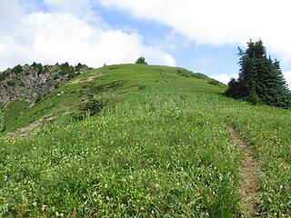 View south from near Excelsior Pass to Excelsior Peak 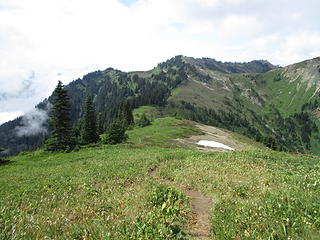 Looking back to Excelsior Pass on alternate path, which climbs to Excelsior Peak and its site of a former lookout. 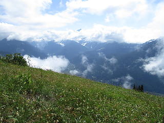 N.Fork Nooksack Valley 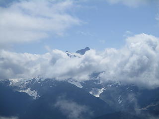 Shuksan peaks out 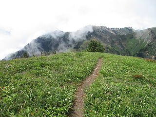 Open meadows near Excelsior Pass 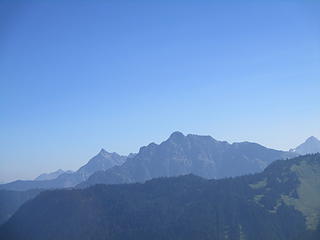 Canadian Border Peak (left), Tomyhoi, Larrabee 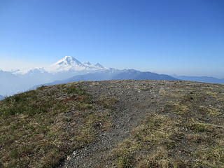 Excelsior Peak, site of former lookout groundhouse 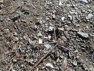 Meager remnants of the lookout 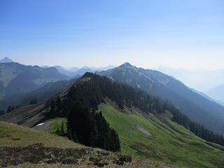 East along the High Divide from Excelsior Peak 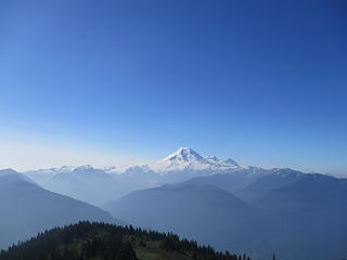 Clearest sky in about two weeks! 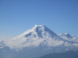 Baker zoomed, but unfortunately in one day the view was of smoke again 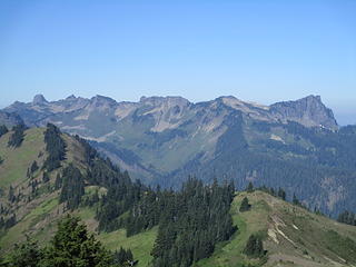 Church Mountain (left) to Bearpaw 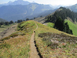 High Divide Trail has few obstacles....good thing, when one is gawking at views like this!  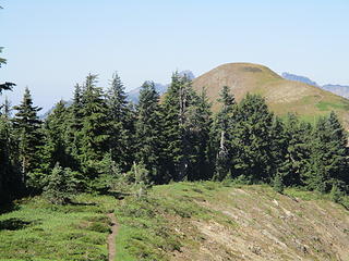 Bald knob is Excelsior Peak 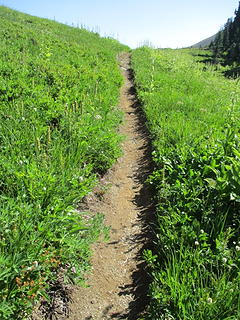 Flowers had peaked already.  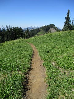 Smooth going! 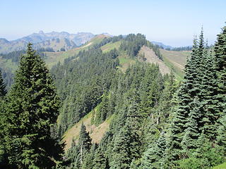 View back west along High Divide, with bald Excelsior visible in center and Church-Bearpaw in distance.  A few flowers remain in bloom 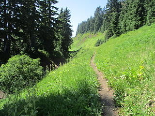 The trail parallels one of the sackungen. About 1/4 mile west of Welcome Pass. 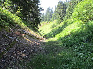 The best view of this particular sackung. Looking west, up-slope is on right. 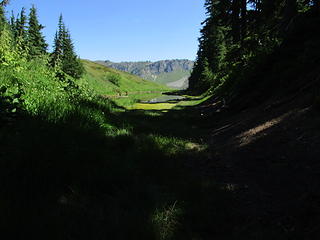 Another view, but shading makes it less obvious. Looking east. 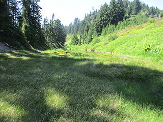 Look closely and you'll see a shallow pond in the sackung. Looking west. I am assuming it holds water for the remainder of the season. 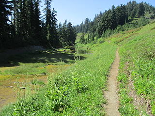 Another view where the trail parallels the sackung. Pond is beyond the tall false hellebore in center. 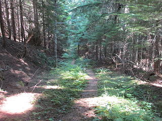 The easy part of the Welcome Pass trail, where the present access road used to continue as a logging road. 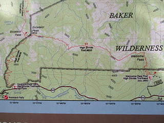 Trails. Excelsior Pass on left (west), Welcome Pass on right, High Divide trail connecting them. Mount Baker Highway is the black line at bottom. The Forest Service calls the whole route the High Divide Trail, but locally we break it down to the three segments for descriptive purposes. 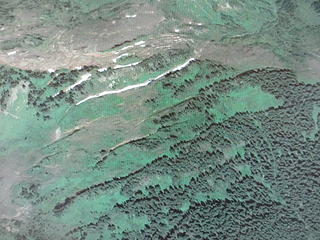 Sackungen from air as marked by linear bands of trees and prominent snow bands. Google Earth image, looking north and upslope. 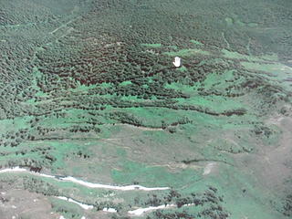 Same but looking downslope and south. (note the hand-shaped snowbank.... actually I just took a picture directly from the monitor and the cursor is a photo-bomber!)
Passing rocks and trees like they were standing still
Passing rocks and trees like they were standing still
|
| Back to top |
  
|
|
Sore Feet
Member

Joined: 16 Dec 2001
Posts: 6307 | TRs | Pics
Location: Out There, Somewhere |
Man, the difference a day makes. I went up there yesterday with the intent of doing Welcome Pass, and you couldn't see the Sisters from Highway 9, Shuksan from 542, or Baker from literally anywhere because the smoke was so thick. Easily the worst I've ever seen it.
|
| Back to top |
|
|
olderthanIusedtobe
Member

Joined: 05 Sep 2011
Posts: 7708 | TRs | Pics
Location: Shoreline |
I missed you by a day Brushbuffalo! Did Excelsior Pass, east along High Divide to Welcome Pass and then back out the way I came in.
As Sore Feet mentioned the haze was pretty nasty. Couldn't see anything.
There were a few berries to be had. The bears have been eating them because I saw several piles of very purple scat along the trail.
|
| Back to top |
|
|
AlpineRose
Member
Joined: 08 May 2012
Posts: 1953 | TRs | Pics
|
We once traversed the High Divide on a two day traverse from Yellow Aster Butte to Church Mt. I remember that sackung! Camped on the divide about halfway along. The only time I used that bivy I'm trying to give away on the Trading Post. Fun times.
|
| Back to top |
|
|
Brushbuffalo
Member
Joined: 17 Sep 2015
Posts: 1887 | TRs | Pics
Location: there earlier, here now, somewhere later... Bellingham in between |
Passing rocks and trees like they were standing still
|
| Back to top |
|
|
raising3hikers
Member
Joined: 21 Sep 2007
Posts: 2344 | TRs | Pics
Location: Edmonds, Wa |
those bright green meadows and blue skies are something to savor right now! glad you got a good weather august hike in 
|
| Back to top |
|
|
zephyr
aka friendly hiker

Joined: 21 Jun 2009
Posts: 3370 | TRs | Pics
Location: West Seattle |
|
zephyr
aka friendly hiker
|
 Sun Aug 19, 2018 9:34 pm |
|
|
| Brushbuffalo wrote: | | I recall this from previous trips on this route but this time figured out that this trench is a sackung, |
Thanks for the geology lesson. I have not heard of these before. I must have missed your prior report on these formations. I just now found this page from Colorado School of Mines. You might like their diagrams. Very interesting that this is from being glaciated. I will have to start looking for these on ridges. ~z
|
| Back to top |
|
|
Brushbuffalo
Member
Joined: 17 Sep 2015
Posts: 1887 | TRs | Pics
Location: there earlier, here now, somewhere later... Bellingham in between |
Zephyr, the cross-sectional sketch (figure 3) in your link is a good one for what I believe is the explanation for the topography in the Welcome Pass vicinity. Glaciation as a factor in formation of sackungen is due to release of lateral pressure by ice after deglaciation.
Thanks for the comment.
Passing rocks and trees like they were standing still
Passing rocks and trees like they were standing still
|
| Back to top |
|
|
olderthanIusedtobe
Member
Joined: 05 Sep 2011
Posts: 7708 | TRs | Pics
Location: Shoreline |
|
| Back to top |
|
|
Brushbuffalo
Member
Joined: 17 Sep 2015
Posts: 1887 | TRs | Pics
Location: there earlier, here now, somewhere later... Bellingham in between |
| olderthanIusedtobe wrote: | | the trail from Excelsior Pass back to the trailhead got significantly longer on the way back, even though it was all down hill |
It often seems longer on the return on the Excelsior trail, probably due to fatigue, decreased enthusiasm, and several eroded rocky trenches that you virtually skipped up hours earlier.
[quote="olderthanIusedtobe"]Strangely it seemed like a lot more uphill going from Welcome back to Excelsior than I realized.
Your senses didn't deceive. Excelsior Pass is about 300 feet higher than Welcome Pass.
| olderthanIusedtobe wrote: | | Do you know about this feature? It was within the first mile or two, right beside the trail. I didn't see it going up but couldn't miss it on the way down.
|
This is a boulder cave in a prehistoric rockfall area. I have never climbed down it ( I'm claustrophobic underground), but a friend did and reported he went down about 20 feet.
The log is recent, not being present last year. It might have been placed to assist a spelunker, or just for the heck of it to get an idea of depth.
There could be other exposed entrances in the area but none immediately adjacent to the trail.
For orientation, Older's picture is looking straight down and for scale , the log is about 6-7" wide if I recall correctly.
Passing rocks and trees like they were standing still
Passing rocks and trees like they were standing still
|
| Back to top |
|
|
olderthanIusedtobe
Member
Joined: 05 Sep 2011
Posts: 7708 | TRs | Pics
Location: Shoreline |
Cool, thanks. I figured I could see between 10-15 feet down the hole, it was too dark to see how far it continued beyond that point. It looked intriguing but I didn't give any serious consideration to descending. Opening was big enough to fit in but not a wide space, probably would've made me feel a bit claustrophobic as well.
|
| Back to top |
|
|
Brushbuffalo
Member
Joined: 17 Sep 2015
Posts: 1887 | TRs | Pics
Location: there earlier, here now, somewhere later... Bellingham in between |
| Brushbuffalo wrote: | | The flowers are past their prime, with only some blooming paintbrush, mountain valerian, and arnica close to Welcome Pass. The peak of berries and the fall color are a month away. |
Update: the trip described above occurred on August 17, 2018. On August 22, 2020 we (seven accomplished ultrarunners, two dogs, and me) repeated the trip but doubled the fun as a ' yo- yo'......up from the trailhead to Welcome Pass, west on High Divide, down from Excelsior Pass to the highway for refueling, then repeat in reverse direction back to Welcome Pass and down that super steep soft path to the trailhead.
22.6 miles r.t. according to GT map, 8,000' ascent, same descent. Time about 9 hours with lots of walking and breaks.
Unlike this same time two years ago, the flowers are glorious, at or just slightly past peak bloom. In general during this August I have experienced some of the best alpine and subalpine floral displays in my recent memory. We had a wonderful day enjoying the show, the mountain views, and the companionship...young people move much faster than this old geezer.
Passing rocks and trees like they were standing still
Passing rocks and trees like they were standing still
|
| Back to top |
|
|
Eric Hansen
Member
Joined: 23 Mar 2015
Posts: 866 | TRs | Pics
Location: Wisconsin |
West of Welcome Pass, as the meadows open up (tent site tad south of trail) look upslope (north) for a tarn that is long and immense. Maybe one of your sackungen? High Divide is good medicine.
|
| Back to top |
|
|
John_B
Member
Joined: 15 Nov 2014
Posts: 50 | TRs | Pics
|
|
John_B
Member
|
Sun Aug 23, 2020 9:09 pm |
|
|
Thanks for the update BB. I remember hiking this 7 or 8 years ago and wondering what was going on with that landform. It's all clear now.
|
| Back to top |
|
|
Brushbuffalo
Member
Joined: 17 Sep 2015
Posts: 1887 | TRs | Pics
Location: there earlier, here now, somewhere later... Bellingham in between |
Yep, all those skinny ponds and depressions are in sackungen. Interesting geomorphology.
Passing rocks and trees like they were standing still
Passing rocks and trees like they were standing still
|
| Back to top |
|
|
|
|
You cannot post new topics in this forum
You cannot reply to topics in this forum
You cannot edit your posts in this forum
You cannot delete your posts in this forum
You cannot vote in polls in this forum
|
Disclosure: As an Amazon Associate NWHikers.net earns from qualifying purchases when you use our link(s). |


 Masochistic? Is there any doubt....
The Excelsior Pass trail is never as steep, and your way allows the pedestrian to stay above timberline for the entire way from Excelsior to Welcome and back to Excelsior. Plus the transpo is a cinch!
I'm going to repeat it by your better version in a few weeks when the color and/or berries are peaking.
Masochistic? Is there any doubt....
The Excelsior Pass trail is never as steep, and your way allows the pedestrian to stay above timberline for the entire way from Excelsior to Welcome and back to Excelsior. Plus the transpo is a cinch!
I'm going to repeat it by your better version in a few weeks when the color and/or berries are peaking. 