Forum Index > Trip Reports > Tradition Peak (aka Rustic Peak) 7747' - the route with no difficulties
 Reply to topic
Previous :: Next Topic
Author Message
Prosit
Member
Member


Joined: 08 May 2011
Posts: 130 | TRs | Pics
Prosit
Member
PostThu Aug 16, 2018 9:12 pm 
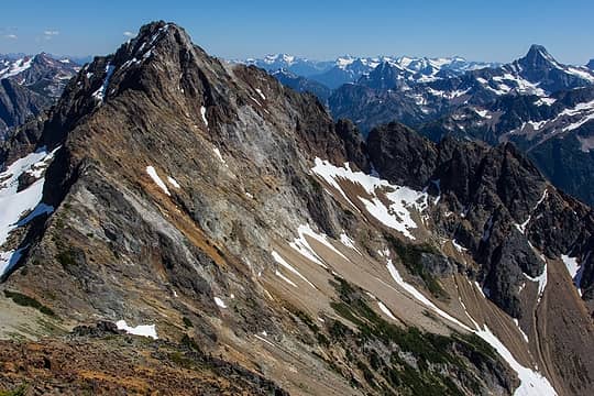
Rustic Peak is the high point of Rusted Ridge, which divides Redoubt Creek from Pass Creek on the north side of the Little Beaver Valley. It has great local relief rising a full vertical mile in one leap from Little Beaver Creek, and more than 4,000’ from Redoubt Creek. Some sources have this mountain as being Tradition Peak. I don’t know the history behind either of these names, but if you do please chime in. Beckey has it as Rustic, and this is likely the name that most people would recognize. I’ve thought about climbing this mountain for quite some time. My first view of it was in 1991, when I did the nice traverse between Whatcom Pass and Mt Redoubt for the first time. I did variations on that same route in subsequent years, working it into larger trips, and twice bivying on the summit of Old Rust, the 7523’ mountain just northwest of Rustic. Rustic is a prominent mountain, and I’ve had good views of it from Prophet Ridge, Eiley-Wiley and even Luna Peak. With each viewing I’ve become more impressed with the mountain, and with its position high above the Little Beaver Valley. Despite its prominence though, it is fairly isolated, and shows its most difficult faces to the north and west, which are the sides most people would notice it from. One day while looking northeast from the nice ridge that juts out over Little Beaver Valley from lower East Lake, I looked up at Rustic and the features of its long south slope. On the map I could see a small lake and Point 6545 above it. It seemed like an ideal camp and viewpoint, and probably just a very nice place to be.
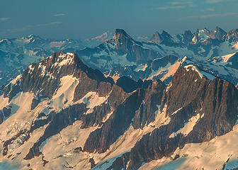
The north side of Rusted Ridge (Rustic on the left, Old Rust on the right)
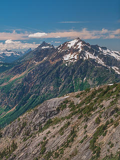
Rustic's south face from Prophet Ridge
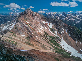
Rustic's NW ridge and west face from Old Rust
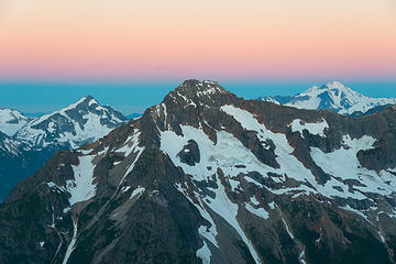
Rustic's north glacier from Tranquility Gendarme
In researching the peak, I thought that the standard approach route (crossing the notch in the East Ridge from the small north glacier) might be difficult depending upon snow conditions. But another approach done by Roper and Lucke ascending the north side of a stream draining from Rustic’s south basin to Redoubt Creek seemed promising, even for a late season climb. Beckey’s description of this route ended with the eye catching phrase “no difficulties” and that sounded good to me. Many, many years later when I briefly asked John about this route, his immediate, visceral response was “that was just awful”. He was talking about the brush in Redoubt Creek of course, but by then it was too late, I was already hooked. In 2013 I viewed Rustic from the Ridge of Gendarmes (RoG) and got a good look at the Roper-Lucke approach route, as well as another route on that side of the mountain I had long wondered about. Redoubt Creek itself also started revealing its secrets and became a less imposing barrier in my mind. The time seemed right, and I made my first attempt on Rustic in 2016. My approach was up the south side of Redoubt Creek, and was influenced by a view I had had in 2013 from the other side of the valley that showed a well-positioned ramp that might shortcut the route up the side-stream drainage toward Rustic’s south basin. The way from Little Beaver Creek up into the Redoubt hanging valley turned out to be open forest on the south side, as it is on the north side. Once I hit the first brush slopes, there was no visibility of the route ahead, so I took my best guess and plunged in. The first section went exceptionally well as I hit a fern corridor after only about 30 feet of alder and was able to ascend and then traverse through these ferns into the next section of tall timber. But starting with the next section of brush, there are no more corridors of timber to target on this slope. It is all just brush and boulder fields. Heading into this second brush section didn’t go so well. Later in the day, when I could begin to see the patterns of this brushy slope, I realized that I had chosen perhaps its worst section to begin my passage. Nonetheless, with patience and perseverance I made gradual progress and learned what I could about this terrain that I would have to come back through on my way out.
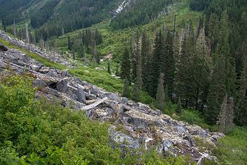
Through the brush to the first boulder field
Eventually I reached the high entrance of the ramp I had been targeting, but it sure looked different up close. Instead of a reasonably level, traversable ramp, I saw a steeply angled, irregular slope covered in soft-stemmed vegetation and with considerable exposure higher up. Still, I thought I’d at least give it a try because it had the potential to shorten the route considerably. I had to round a miniature buttress and climb up a slabby step to get up there, but all of this was covered in chest high, soft vegetation and as a bonus, the rock was wet with a trickling seep of water. I made a creative start but it was difficult and the terrain I could see ahead of me was sure to be even harder. After a little more investigating, it became apparent that I would have to give up the idea of using the ramp. Later when I was able to view it from the other side, I was glad I did, because there are some nearly vertical sections of it around the corner – it just doesn’t go. My option now was to descend to the river and look for the original route up the north side of the side-stream from there.
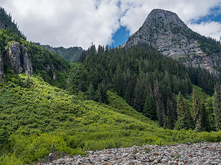
The side-stream step
From the river, once north of the side-stream, the view is of a wide brush slope that goes up into steep trees. At first glance the entire slope seems plausible, though steep higher up; and this is also what I had seen in 2013 from the other side of the valley. The map showed a band of cliffs hidden in those trees, but I couldn’t see them, nor had I been able to see them from across the valley. The map suggested that the most climbable contours were on a rib right next to the stream, so that is what I went for. Once I started up, I could begin to see where the cliffs were. The brushy slope went from an easy fireweed clearing to more difficult alder, but it didn’t get steep until I reached the small conifers on the rib. The rib forms a cliff on the stream side immediately, and drops increasingly steeply to the other side as you ascend. I was able to climb a fair ways up it, but when I reached the area where I was even with the cliff band off to my right, I hit a section of steep slabs covered in dense, large diameter krumholtz. I tried for quite a while to figure out a way up this. There was no way I was going to be able to climb it with a pack on, but I did have a short section of cord that I might be able to pull my pack up with behind me. The best I was able to do was to find a place where I could put my back against the needle-covered slab, reach as high as I could to grab branches and try to pull myself up through small gaps under the trees, shimmying my back up the slab and using only the tree branches for purchase. But I wasn’t able to pull this off for the entire height of what I had to climb and there were no foot-holds so I was climbing and hanging from my hands only. It seemed like had I been able to climb 20 more feet, I would have been over the crux, but it didn’t work. There was no option to traverse off the rib to try a variation on the route, and there were visible cliffs all the way across what I could see in any case. Reluctantly, I began to descend back down to the river. At the river, I had some food and relaxed. It was getting late now and my major efforts for this day were over. I took an easy walk upriver along sandbars to get a better view of the upper valley, but then returned to my pack. There is a small forested area near the confluence of the side-stream and Redoubt Creek, and in this forest I found a very nice campsite next to a stream. I set up camp as my thoughts drifted to what I might do the next day.
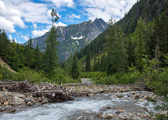
Revelations from the Redoubt Valley
There was another route on this side of the mountain I’d been curious about for many years. This is the broad, very steep ridge that ascends from the lip of Redoubt Creek’s hanging valley and becomes the southern containment wall of the side-stream drainage I had just failed to ascend into. I hadn’t found any information on this ridge, but could see that rough areas were indicated on the map, not to mention that it might not even be possible to get onto it, given the cliffs around its steep footings. I’m partial to ridge routes though, and this seemed like an elegant, original solution if it did go. Views I’d had from the RoG in 2013 confirmed the rough areas were significant, but those views weren’t conclusive about its viability. I would have to go there to find out. Now I had my chance, and this I decided, is what I would set out to explore the following day. In the morning I slept in, and eventually rose well refreshed. I took my time, enjoying a brilliant blue sky, vivid green flora and dazzlingly bright rock all around me in this very wild valley. In due time, I was ready to begin my way back out through the brush. I’d learned quite a bit on the way in, and took some variations on the way out that were much better. It was still a slow route, requiring ample patience, but I was in the right frame of mind for it, and thought it went well. I used a photograph I’d taken from the CoG in 2013 to select a route for getting up onto the ridge I now wanted to explore. All routes looked iffy, but I took an educated guess and began to climb. As luck would have it, my route went right up to the corner of a cliff band and there was a very small passage there that I was able to get up through. Very steep trees followed, but their denseness and small trunks meant I had lots of good hand and foot holds on those trees to make the climb doable and safe. Without those trees, I probably wouldn’t have been able to climb it. In time the slope angle began to ease and the trees began to open up. In a few hours, I was on heather in attractive parkland heading up the ridge. It felt great to be up into the views again and I felt encouraged. When I reached Point 5521 however, I encountered the first of the rough areas. Just above, there is a notch in the ridge and a vertical wall to surmount. I dropped my pack and went to explore but found no viable route I could take to get around or above it. There is an exposed, narrow, vegetated ramp that traverses one side of that wall and could be a route, but it would be tricky, and I didn’t have gear to protect it. This would be my second attempt at reaching Rustic that would be stopped short during this trip, but the silver lining this time was that point 5521 is a tremendous viewpoint. On the way up, I had noticed a fortunate, water-filled pothole a few hundred feet down the ridge from where I was, and this provided an ample water source. I decided to camp on the ridge for the night. In late afternoon, clouds came in quickly from the southwest, and it became clear that a broad storm front was approaching. My camp was well protected and I love cloud views, so I enjoyed this, and happily snapped photos as the sky moved light around the landscape. Toward evening there were times when sunlight got through to high clouds that would reflect that sunlight back down onto the eastern, shaded sides of mountain slopes. It’s a beautiful lighting effect. The sunset was wonderful, and the rain held off until it was over, but when it finally came, it came hard. It rained most of the night, but stopped a few hours before sunrise.
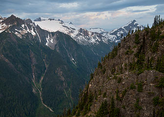
Mt Challenger and Whatcom Peak
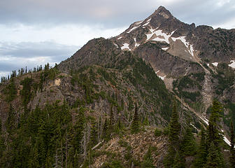
The upper southeast ridge to Rustic Peak
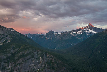
Clouds and light over Beaver Pass
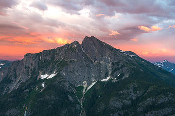
Revelations in appropriate light
There was some sunrise color that seeped through from the northeastern horizon, but it was a mostly dark morning. Views were good though as the clouds stayed above most of the nearby peaks. Mt Redoubt came in and out of clouds and it wasn’t clear if the storm would move on or double down on this day. Unhurriedly, I packed up camp and spent some of the morning just looking around at the fine views. Eventually, it started to rain again and I started heading back down the ridge in full raingear for the wet brush and trees I would slither through on my descent. I hiked out and ended the trip from there.
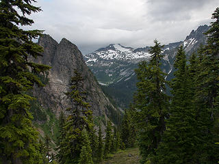
Morning clouds and rain over Mt Redoubt
As you may have guessed, I’ve recently made a second attempt at Rustic in 2018. When I had descended down to the river after my first failed attempt to ascend the rib next to the side-stream, I spent some time studying the map and walking up and down the river to get different view angles of the whole slope in the area of that side-stream. One thing that struck me was that there were no waterfalls in that side-stream as it passed through the elevation where the cliff band was. It appeared to cascade down at a pretty steady angle. It occurred to me that if one were to simply ascend the streambed that might be the most gradual route on the entire slope. The other thing I noticed is that far to climber’s right of where the cliff band contours end, there were some brush choked slide paths that ascended much higher into forest. No cliffs were visible here, and the map suggested that though it was steep up high under those trees, it didn’t necessarily indicate cliffs the way it did with the lower cliff band, so maybe it would go. The brush went up a long ways there however, and the thought of climbing through that brush wasn’t attractive. By the time of my 2018 attempt, I had convinced myself through studying photos that I’d taken, that the streambed would go, and so I set out to climb it. To aid my effort, I took along some water sandals that have much more structure than my normal Teva’s. I also took a pair of thick neoprene socks, which I’ve used for years on trips where a significant ford or river walk was anticipated. I like them a lot. Retracing my previous route to the second section of brush in Redoubt Creek’s hanging valley, I decided to try a new option. I knew that there were significant sandbars along the Redoubt for much of its length. I had good water wading footwear with me. I decided to descend to the Redoubt and see if I could make my way up along the river itself. At the point where you hit the river here, there are some large-boulder rapids, some log jams, and little in the way of sandbars, so I bashed and clawed my way up through the brush right along the river. Twice I went into the streambed for very short sections before climbing back into the brush again, but after only about half an hour of this very thick brush, I hit a small forest grove right on the river that marks the start of a consistent stretch of sandbars and gently graded riverbed going up the valley. I was able to walk up the river all the way to the side-stream with little trouble, and indeed with real pleasure. It’s a beautiful, wonderful little section of river to walk up. This is definitely the best way to go up the Redoubt, but you need to be able to walk right in the river for extended stretches. My experience this early August was that the deepest pools were only knee deep, and the strength of current was not an issue. It was really fun, especially on a warm, sunny day.
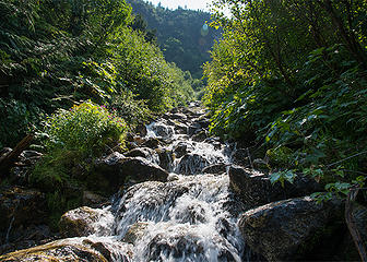
Heading up the side-stream
From my previous trip, I also knew the most efficient and brushless way to get into the side-stream. Once there, I began carefully climbing upstream. The gradient was fine, but what I hadn’t anticipated was just how slippery the rocks would be. I knew my water sandals to have superior gripping ability on anything wet or dry, but all bets were off if the wet rock was covered with slimy algae, and this is what I found in this streambed. I continued to ascend, but found I had to go slow and take great care not to slip. Eventually, I opted to climb into the brush on the right side for a while before returning to the stream when that brush blanked into a rock wall. After some more streambed ascending, I climbed into brush on the left side to avoid a steeper section in the streambed. Here I began to have some trouble. I made a couple forays up, only to descend back and try again at a different distance from the streambed. It became pretty steep and I looked for ways to make the streambed work again. After a fair amount of consideration, I came to the conclusion that I would be pushing my luck to press on with the super-slippery route I’d chosen. With the size of the river boulders increasing and the grade steepening, I decided that it would be unsafe. Once again, Rustic would be turning me around to descend back to the river. As I descended, I felt a little dejected for a short time, but soon had to laugh at how consistently the mountain had been fending off my advances. Just for fun, I anthropomorphized a bit and had what I thought was a persuasive, if one-sided conversation. But despite another failure, I found my mood becoming light again. I noticed some small yellow flowers along the streambed and saw a bee fly to one and grasp it to harvest its sweetness. The stem bent almost all the way to the ground under the bee’s weight. The bee was unfazed and flew to the next one, repeating its bungee-jump acrobatics. There was brilliant green moss that formed a flowing pattern on a big rock almost like the script of some exotic, logographic language. Two orange butterflies crossed in front of me, chasing one another in semi-circles before rising away from the stream, up and over the brush. For all of the convenience and certainty of having established beta for a particular climb, there is still something to be said for setting out on one where the way isn’t clear and you have to rely upon your own imperfect intuition. Certainly you get to know the mountain better; and it may teach you a thing or two along the way. The one remaining route I could think of was the high brushy slide paths that run up to the right of the lower cliff band. I had had a slight revulsion at the thought of climbing them when I first saw them, because I assumed that they would be climbing through brush-hell at a steep angle, probably with inconsistent, rocky talus under foot. Now I began preparing myself mentally for one last try.
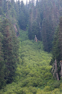
Looking up at the middle section of the first brush gully
The sandbars on the river change every year and where I remembered there being a small log jam in 2016, this year there was a flat, sandy spot perfect for my tent. I pitched it there, right out in the open of the riverbed and had nice views for the evening. Right next to my camp was a lonely stand of cottonwoods stranded in the middle of the wide riverbed, with a perfect branch to hang my food from, and under it, a water-eroded, smooth trunk-log that curved to form a fine place to sit and cook dinner. I felt a nice sense of ease that evening. I felt relaxed. Perhaps it was the wide open views I had, not unlike being up high where you can see forever. Maybe it was knowing that I had tried my best to find a route I could climb here. But maybe too it was just familiarity. I’d been into this river valley three times now in recent years, and on each trip had learned more about it. It was beginning to feel like an old friend. In the morning, I arose and packed up early to get a jump on what I expected to be a very warm day. I headed upstream to the place where I could begin the climb. I wandered through some minor lowland brush in a dry river channel and made my way through a barrier wall of alder onto a very old section of larger-rock talus strewn with the dissolving remains of what must have once been very large trees. Above this I headed into the brush, but almost immediately, I was surprised. As soon as I stepped off of that talus, my feet were on soft but cohesive soil and not rocks. Ahead of me, tall Bracken ferns led upslope amidst slide alder trees that were spaced in such a way as to present no real barrier to my passage. I followed the ferns up and they just continued. Underfoot, the soil was perfect footing. I felt almost giddy. If not for the time I had to spend parting the head-high ferns so I could see where I was going, I would have been able to march right up the slope. There were denser sections of alder, but the open sections and fern corridors offered easy ways around them. There are two forest islands in this brush section and I decided to make my way right, into the smaller one to see what the route looked like in the forest. It was wide open and inviting, so I continued up to its high point, where I again entered ferns and well-spaced slide alder on soft soil. I headed up to the toe of the next forest area just above. Upon entering that forest, I continued up, eventually moving right into and across another minor vegetable gully and out onto an adjacent forest corridor, then gradually angled back higher up to eventually reach the original, ridged, forest corridor again. Some of this forested terrain got very steep and that is what led me to angle in one direction or the other. It was sometimes arduous climbing, but it was safe and steady. Once I got back to the original forested ridge, it was all very steep terrain, but with plenty to hold onto. I looked across to the other side of the ridge and could see the top of the brush slide path blanking into a cliff wall that had been hidden in the trees. This meant of course that following that slide path all the way to its top would actually have been a dead end. I had gotten lucky this time by going into the forest. I had imagined that eventually I would reach a ridge crest angling down toward where the side-stream reaches its upper basin, which was now well below my current elevation, but unseen. But above me I saw only increasingly steep terrain. Above and to the right I could see steep dirt paths going up through channels in a cliff band like Swiss cheese and it didn’t look appealing. But up and to the left I saw more forest that looked like it might be angling around as if it was going around a corner. I ascended another 50-60 feet here. A 30 foot leftward traverse on steep forest duff appeared to be the last obstacle. This short section was a little touchy, as it was steep and exposed, but the soil was soft enough to actually kick shallow footholds and I self-belayed the short parts where I couldn’t reach a tree with my ice axe pick. As soon as I got across, I could see around the corner and knew I was at the crest of the basin. From here, I traversed easily southeast through forest until I reached the bottom of a large boulder field descending from point 6232 and its slightly lower neighbor and then traversed that talus field into the basin proper at around 4500-4600’. The ascent from there up to the small snow lake at 6420’ was straightforward. There is a steeper middle section followed by a snow basin that is more moderate. The little snow headwall at the top is a moderate walk-up.
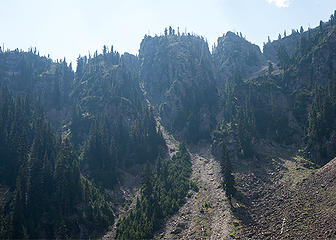
Looking up from the side-stream basin, at notches in the southeast ridge
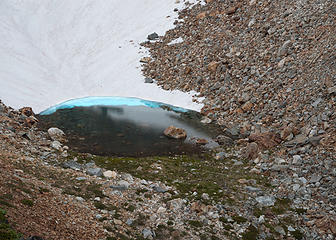
Small lake in the south basin
That little lake is a pretty sight. Mostly melted out, it was bounded on its east side by attractive green grass and heather. The water was crystal clear and the rocks under the water were very colorful, along with the water itself. I found a large meadow on Point 6545 that made for a very nice high camp. The views from here are really something, especially toward Challenger, Whatcom and the upper Little Beaver Valley. After all of those attempts, I had finally made it up to this fine area. It felt great. Of course, there was one more thing on my mind. Looking up at Rustic from here, you see a cliff band that runs all the way around the basin, except for one steepening funnel of scree at its northeast edge. At the top of that scree, there is a snowfield with a wind-formed crest that makes climbing across it to gain the upper slopes steeper than it would otherwise be. I also knew from distant views and photos that there was a deeply eroded dike that cut vertically down through the basin. I could only see the top of it from where I was, but in order to climb from the scree-snow area to the summit, you’d also have to climb above and around that eroded dike, and though it was no Perfect Impasse, it didn’t look particularly easy. In the evening light, I did not see another way through the cliffs. I decided not to worry about this for now, and instead, spent the late afternoon and evening on Pt 6545 enjoying the great views. My plan would be to give the summit a try in the morning.
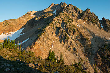
Morning view of Rustic from Pt 6545 - ramp is at far left, notch of standard route on far right with remnant snow
In the morning light, I immediately saw what I’d completely missed the day before – a ramp angling up and left from the basin snowfield up through the left side of the lower cliffs. My spirits rose and I started up to check it out. The ramp went very well, though it was steep in places and I did use my ice axe on some of the heather. From the top of the ramp I was at the base of easy talus slopes heading up the mountain. Angling right avoided a lower angle cliff band on the upper mountain and angling back left to a col in the southwest ridge at an area of very dark red rock set me up for the final scramble up the ridge to the summit. Forest fire smoke was an issue throughout this trip, but I had started the climb early enough in the day to give myself a shot at some views of the neighboring peaks from the summit. I did get some good views, but by late morning those views had dissolved into a nebulous haze, and I began heading back down to my camp.
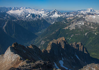
Summit view to the southwest
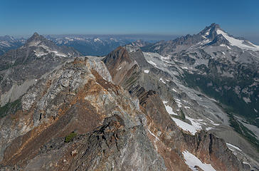
Summit view to the northwest
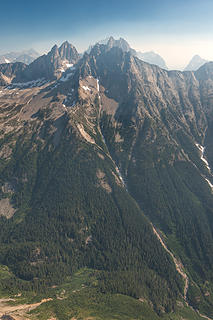
Summit view of Mox Peaks
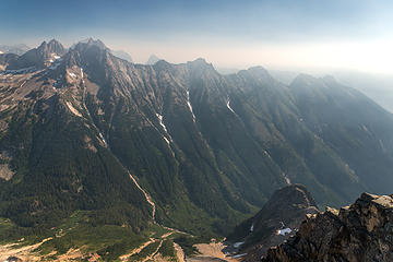
Smoke coming in over the Ridge of Gendarmes
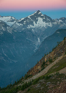
Despite the smoke, I was enamored enough with the location that I decided to spend another night there hoping for the smoke to clear out for the next morning’s sunrise, if not for the coming sunset. Despite the effort required, I might well return here someday, for views without smoke. There is another route from the East Lakes/Pass Creek side that I might try. I’ve wanted to go back there again as well. So many fine places; so many fun routes… no difficulties that I can recall.
Whatcom Peak
Whatcom Peak
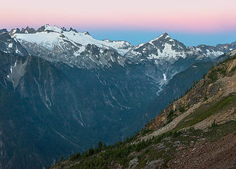
Sunrise view up valley

Back to top Reply to topic Reply with quote Send private message
awilsondc
Member
Member


Joined: 03 Apr 2016
Posts: 1324 | TRs | Pics
awilsondc
Member
PostThu Aug 16, 2018 9:21 pm 
Way to make an appearance Prosit! WOW! First TR in 2 years, and it's a dandy! I'm only a quarter through right now, but... pretty bad ass. Thanks for posting! up.gif up.gif up.gif up.gif Edit: I finished reading, and it didn't disappoint! Your memory is incredible, and your descriptions rich with detail. I felt like I was right there with you. I particularly enjoyed this passage - "But despite another failure, I found my mood becoming light again. I noticed some small yellow flowers along the streambed and saw a bee fly to one and grasp it to harvest its sweetness. The stem bent almost all the way to the ground under the bee’s weight. The bee was unfazed and flew to the next one, repeating its bungee-jump acrobatics. There was brilliant green moss that formed a flowing pattern on a big rock almost like the script of some exotic, logographic language. Two orange butterflies crossed in front of me, chasing one another in semi-circles before rising away from the stream, up and over the brush. For all of the convenience and certainty of having established beta for a particular climb, there is still something to be said for setting out on one where the way isn’t clear and you have to rely upon your own imperfect intuition. Certainly you get to know the mountain better; and it may teach you a thing or two along the way." Not many people go on these kind of adventures anymore, or take the time to write it up like you did. Thank you!

Back to top Reply to topic Reply with quote Send private message
Matt
Tea, Earl Grey, Hot


Joined: 30 Jan 2007
Posts: 4308 | TRs | Pics
Location: Shoreline
Matt
Tea, Earl Grey, Hot
PostThu Aug 16, 2018 10:04 pm 
Great report and storytelling. Thank you for including all the details along the way; it really gives a feel for the difficulty of the area and your persistence finding a way through it. I've been curious about this peak for a long time, thinking about approaching from Bear Lake. I'll have to go back over your report with a map in hand to figure out how you approached it.

“As beacons mountains burned at evening.” J.R.R. Tolkien
Back to top Reply to topic Reply with quote Send private message
Gimpilator
infinity/21M


Joined: 12 Oct 2006
Posts: 1684 | TRs | Pics
Location: Edmonds, WA
Gimpilator
infinity/21M
PostThu Aug 16, 2018 10:04 pm 
Pretty amazing. I had wondered if we would see any more from you. I took an interest in this peak after seeing it from Elephant Butte. I have looked into routes and even asked some very experienced people what they know about it. I never expected to see a trip report. Bravo!

Back to top Reply to topic Reply with quote Send private message
puzzlr
Mid Fork Rocks


Joined: 13 Feb 2007
Posts: 7220 | TRs | Pics
Location: Stuck in the middle
puzzlr
Mid Fork Rocks
PostThu Aug 16, 2018 10:16 pm 
I admire the persistence and your description of discovering the route. It takes a lot of energy but the reward is satisfaction of doing a hard thing. Thanks for writing it up in detail -- I enjoyed reading the whole thing.

Back to top Reply to topic Reply with quote Send private message
iron
Member
Member


Joined: 10 Aug 2008
Posts: 6392 | TRs | Pics
Location: southeast kootenays
iron
Member
PostThu Aug 16, 2018 10:36 pm 
good stuff. i'm sure the rhino will enjoy seeing this TR. this has to be one of the least climbed peaks in the state. our views of it from cave lake said: meh, i'd rather not. we should've, but that's another story. great persistence and attitude. i wish i had your level of both of those!
tradition from old rust (NW)

Back to top Reply to topic Reply with quote Send private message
Distel32
Member
Member


Joined: 03 Jun 2014
Posts: 961 | TRs | Pics
Location: Edmonds, WA
Distel32
Member
PostFri Aug 17, 2018 6:58 am 
up.gif

Back to top Reply to topic Reply with quote Send private message
RichP
Member
Member


Joined: 13 Jul 2006
Posts: 5634 | TRs | Pics
Location: here
RichP
Member
PostFri Aug 17, 2018 7:50 am 
I enjoyed your report immensely. So much so that I read it twice.

Back to top Reply to topic Reply with quote Send private message
raising3hikers
Member
Member


Joined: 21 Sep 2007
Posts: 2344 | TRs | Pics
Location: Edmonds, Wa
raising3hikers
Member
PostFri Aug 17, 2018 5:48 pm 
nicely done and I really enjoyed reading your TR! I took a few pics of it on my redoubt high route trip a few years ago and it's been on my mind ever since. thanks again for the inspiring report up.gif

Eric Eames
Back to top Reply to topic Reply with quote Send private message
Stefan
Member
Member


Joined: 17 Dec 2001
Posts: 5093 | TRs | Pics
Stefan
Member
PostSat Aug 18, 2018 12:50 pm 
Awesome. So did you carry your gargantuan photo setup this time?

Art is an adventure.
Back to top Reply to topic Reply with quote Send private message
Prosit
Member
Member


Joined: 08 May 2011
Posts: 130 | TRs | Pics
Prosit
Member
PostSun Aug 19, 2018 5:39 pm 
Stefan wrote:
So did you carry your gargantuan photo setup this time?
Hi Stefan - I am carrying the same setup you witnessed. I've received some information about the naming of this peak as follows: "Tradition Peak was the name applied 40 years ago in 1978 by the 2A party (the 1964 FA party offered no name) to commemorate the traditions Washington climbers have established in the mountains of the North Cascades; like your tradition of summit camps, of climbing friends traditionally going out together week after week or year after year, of climbers traditionally returning to their favorite mountain-top haunts." It looks like "Rustic" may have been a Fred invention. I've edited the title of this post slightly to put the Tradition name more forward. The Rustic name is still probably best known simply because it is the name in the CAG, and the CAG is the best known guide. Thanks very much for all of your comments.

Back to top Reply to topic Reply with quote Send private message
   All times are GMT - 8 Hours
 Reply to topic
Forum Index > Trip Reports > Tradition Peak (aka Rustic Peak) 7747' - the route with no difficulties
  Happy Birthday theCougAbides!
Jump to:   
Search this topic:

You cannot post new topics in this forum
You cannot reply to topics in this forum
You cannot edit your posts in this forum
You cannot delete your posts in this forum
You cannot vote in polls in this forum