| Previous :: Next Topic |
| Author |
Message |
Noheaperture
Nohea

Joined: 25 Aug 2018
Posts: 130 | TRs | Pics
Location: Issaquah |
So Ive been in Seattle for 10 months from Hawaii and have spent the entire summer bagging as many alpine lakes with my 1 year old golden retriever to cancel out the idea of my first brutal winter here (I know, I need to toughen up. Haha) Shes done everything with me along the I-90 from dip top gap, robin lakes, the wildcats and we did a quick overnighter up to thunder mountain last week.
I want to do a 3 day trip to Spade and explore some of the amazing tarns up above around Venus and circle. I was wondering how manageable the ascent would be with my dog to get to Venus from spade? I have great route finding skills and am an Eagle Scout (if that honestly means anything still, idk...) but havent found much info regarding the trek even through some deep web searches. Tips and suggestions in any manner would be great.
|
| Back to top |
  
|
|
olderthanIusedtobe
Member

Joined: 05 Sep 2011
Posts: 7722 | TRs | Pics
Location: Shoreline |
There is a huge slab between Spade and Venus that looks steep from below. It's just to climber's right of the drainage between the 2 lakes. Walking up it is non-technical, really fun I thought. I'm not sure how dogs do on angled slabs though. Are their pads + toe nails comparable to a vibram type of sole on a boot?
Here's a picture of the slab from Spade. I went Circle>Venus>Spade and then back again.
There is some cruddy talus/scree between Venus and Circle, kind of tedious.
|
| Back to top |
|
|
Tom
Admin
Joined: 15 Dec 2001
Posts: 17857 | TRs | Pics
|
|
Tom
Admin
|
 Sat Aug 25, 2018 12:24 pm |
|
|
The slab is polished rock so should be easy on dog pads. Not sure about the rest of the XC route as far as dog pad impact. Since you indicated you had good routefinding skills you might want to consider looping out via Deadhead and Vicente. My suggestion would be Cathedral TH > Squaw > Peggys > Circle > Venus > Spade > Deadhead > Vicente > Deep > PCT > Squaw > Cathedral TH. Doable in 3 days. We did a similar loop as a long overnight.
|
| Back to top |
|
|
Randito
Snarky Member

Joined: 27 Jul 2008
Posts: 9513 | TRs | Pics
Location: Bellevue at the moment. |
|
Randito
Snarky Member
|
Sat Aug 25, 2018 12:41 pm |
|
|
Depends a lot on the dog and what sort of shape they are in.
My current dog used to hike/scramble some pretty gnarly terrain -- but she is 15 now and has arthritis and a number of other issues. We hiked to Robin Lake several years ago when she wasn't as limited -- but she needed a lot of more "boosts" on the section right above from Tuck Lake with it's steep "trail" than from years earlier. Up on the "slabby" section a little higher she was back into "What's the hold up slow human" mode.
Anyway if your unsure about their agility -- I recommend getting harness for your dog and some rope so that you can help them up and down steeper sections without having to carry them in your arms.
|
| Back to top |
|
|
jupsal
Member
Joined: 20 Aug 2017
Posts: 49 | TRs | Pics
|
|
jupsal
Member
|
Sat Aug 25, 2018 1:13 pm |
|
|
| Tom wrote: | | My suggestion would be Cathedral TH > Squaw > Peggys > Circle > Venus > Spade > Deadhead > Vicente > Deep > PCT > Squaw > Cathedral TH. |
I did the first part of this exact suggestion last month. I would think it might be tough from Circle to Venus for a dog. I had to cross some ice that I wouldn't have been totally comfortable doing without an ice axe. FWIW I have also never hiked with a dog, so I don't know how tough something like that would be for them.
|
| Back to top |
|
|
AlpineRose
Member
Joined: 08 May 2012
Posts: 1953 | TRs | Pics
|
Dogs vary in their climbing abilities. You will have to find out what your dog can do.
Watch Biscuit the Climbing Dog send it.
|
| Back to top |
|
|
joker
seeker

Joined: 12 Aug 2006
Posts: 7953 | TRs | Pics
Location: state of confusion |
|
joker
seeker
|
Sat Aug 25, 2018 2:09 pm |
|
|
The problem with Tom's suggestion is that if the terrain between all the lakes is too tough for the dog, you won't see Spade or Venus at all. If you would prefer to see Circle above the others, I guess that would be OK. But if you'd rather see just Spade, then coming up from Waptus would give you that and you could see from there how far you want to take the pup.
|
| Back to top |
|
|
Tom
Admin
Joined: 15 Dec 2001
Posts: 17857 | TRs | Pics
|
|
Tom
Admin
|
Sat Aug 25, 2018 2:38 pm |
|
|
Hmm, well the route I suggested may be too tough for a dog, but you'll definitely see all the lakes. I wouldn't recommend the route we did (up Daniel then scrambling down to Venus). I did the long slog to Waptus and up to Spade and Venus when I was much younger. Wouldn't recommend it for the investment required.
|
| Back to top |
|
|
joker
seeker
Joined: 12 Aug 2006
Posts: 7953 | TRs | Pics
Location: state of confusion |
|
joker
seeker
|
Sat Aug 25, 2018 4:21 pm |
|
|
You're making me miss the days when it was a pretty reasonable day one to go up and over DMG to get there...
|
| Back to top |
|
|
Noheaperture
Nohea
Joined: 25 Aug 2018
Posts: 130 | TRs | Pics
Location: Issaquah |
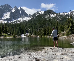
Thanks for the sound advice everyone! This community is awesome! I feel she will be totally fine, I just didnt want to hike 15 miles in through Waptus and find out the climb above spade was all above class 2. My main goal is to get to these gems and camp nearby on my second night after a stay at spade. Have any experience getting to these tarns when you did your hike? Its been my dream through the summer to get here. Absolute buckelist spot for me.
 Epic Venus tarn 1 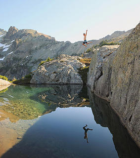 Ultra epic Venus tarn side angle
|
| Back to top |
|
|
olderthanIusedtobe
Member
Joined: 05 Sep 2011
Posts: 7722 | TRs | Pics
Location: Shoreline |
Getting up above Venus to the tarns is a bit tricky. Several dead ends. Just weaving back and forth along benches and ledges. It goes, might have to do some trial and error. Eventually it opens up and gets fairly easy. I think the tarns themselves should be easy enough to find once you are around the right elevation.
|
| Back to top |
|
|
AlpineRose
Member
Joined: 08 May 2012
Posts: 1953 | TRs | Pics
|
|
| Back to top |
|
|
Tom
Admin
Joined: 15 Dec 2001
Posts: 17857 | TRs | Pics
|
|
Tom
Admin
|
Sat Aug 25, 2018 9:22 pm |
|
|
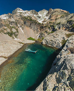
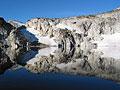
I'm sure that tarn takes a nice picture from the right angle but there are probably more comfortable and scenic spots to camp (albeit not between Venus and Circle).
I'm guessing this is the tarn. Might dry up or turn stagnant later in the season.
Here's a view of the terrain from Randy's 2008 TR:
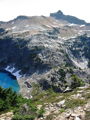 1 label Route passes just left of The Citadel. Venus at left.
|
| Back to top |
|
|
Noheaperture
Nohea
Joined: 25 Aug 2018
Posts: 130 | TRs | Pics
Location: Issaquah |
Absolutely blown away by that place. Ill be heading up there next week so hopefully a great trip report and shots to come. Thanks everybody!
|
| Back to top |
|
|
|
|


