| Previous :: Next Topic |
| Author |
Message |
Exmoor
Member


Joined: 20 Mar 2013
Posts: 89 | TRs | Pics
Location: Snohomish |
|
Exmoor
Member
|
 Thu Aug 23, 2018 4:26 pm |
|
|
I'm headed up to the base of Glacier Peak early next week, mostly in search of high altitude bird species. In my research I came across a map of the Glacier Peak Meadows Trail, which I'd never heard of. Someone did post a screenshot of a map (attached, sorry I don't recall whose post it was for credit) with a trail. Since this is the only map I've seen of this trail I was curious if anyone had any information on it? Is it established and fairly easy to find from the east side?
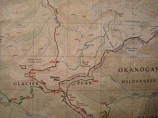 GlacierPeakMeadowsTrail
|
| Back to top |
  
|
|
yukon222
Member

Joined: 12 Mar 2007
Posts: 1893 | TRs | Pics
|
|
yukon222
Member
|
Thu Aug 23, 2018 4:51 pm |
|
|
I'm not familiar with that trail, but I think the pic below might be of those meadows. I took it from the top of White Mountain during "The Painted Traverse" trip. Looking South from the peak, it is in the general correct direction of your meadows. Lush area even though we were there on September 1st, 2012.
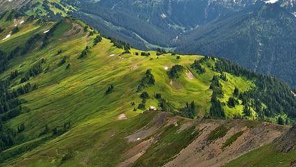 DSF_2497 - Ridge Ramblin'
|
| Back to top |
|
|
gmjbs
Member
Joined: 24 Jul 2017
Posts: 4 | TRs | Pics
Location: Seattle |
|
gmjbs
Member
|
Thu Aug 23, 2018 5:00 pm |
|
|
Access from the east I think is from what's known as the Foam Creek Trail, which also provides access to the pretty cool White Chuck Basin.
There's a good report with descriptions, pictures, etc. of access from that side in the trip report here https://www.nwhikers.net/forums/viewtopic.php?t=8012725
|
| Back to top |
|
|
neek
Member

Joined: 12 Sep 2011
Posts: 2337 | TRs | Pics
Location: Seattle, WA |
|
neek
Member
|
Thu Aug 23, 2018 5:15 pm |
|
|
Huh, aerial maps do show trail remnants along that path, starting about 1/4 mile down the outlet stream of Lake 6443 and meeting the PCT at 5500 ft as your map shows. Seems like a fun adventure for someone with good wilderness navigation skills and ability to handle rough terrain.
|
| Back to top |
|
|
olderthanIusedtobe
Member
Joined: 05 Sep 2011
Posts: 7709 | TRs | Pics
Location: Shoreline |
|
| Back to top |
|
|
Exmoor
Member
Joined: 20 Mar 2013
Posts: 89 | TRs | Pics
Location: Snohomish |
|
Exmoor
Member
|
Thu Aug 23, 2018 5:35 pm |
|
|
Thanks, I hadn't seen that report. From their GPS track at the bottom it looks like they went on the south side of the White Chuck Mountain/ridge, rather than the north side that I'm looking at. Still nice to see photos to help me judge what the habitat looks like up there.
| olderthanIusedtobe wrote: | | I've passed through there. Bits and pieces of a boot path but not much. Terrain is easy enough to navigate through though. Follows a really cool outlet with a series of waterfalls. Some pics in this TR of mine.
https://www.nwhikers.net/forums/viewtopic.php?t=8012397 |
Thanks for the info. That trip report and photos are very helpful. I'm thinking I'll go in to the basin the traditional way (Foam Creek) and hopefully exit the same way you did. Nice to know its navigable.
|
| Back to top |
|
|
braincloud
Summit Seeker
Joined: 30 Jul 2008
Posts: 186 | TRs | Pics
Location: The crooked path |
| yukon222 wrote: | I'm not familiar with that trail, but I think the pic below might be of those meadows. I took it from the top of White Mountain during "The Painted Traverse" trip. Looking South from the peak, it is in the general correct direction of your meadows. Lush area even though we were there on September 1st, 2012.
DSF_2497 - Ridge Ramblin' |
That's White Pass (camping area in that bowl on the right) and the PCT running SE along the ridgeline through the center. From that view, the Glacier Meadow trail would be behind you and to the left at about 8 o'clock.
Can't speak as to whether there is a defined trail in the basin as every time I've been in there, it's been still covered in snow ...
|
| Back to top |
|
|
D.B. Cooper
Member

Joined: 26 Oct 2003
Posts: 45 | TRs | Pics
Location: Lake Stevens, WA |
I was in that area around 2003 I believe. I camped North of the site of the old shelter on the map. Visited the Cinder Cone in the morning then crossed over the PCT and headed up to Lake 6443.
I was probably on the route of your trail starting at around the 6000' contour. I don't recall ever noticing a trail. But like previously mentioned the whole area is pretty wide open so no trail needed.
|
| Back to top |
|
|
Jordan
y

Joined: 22 Feb 2008
Posts: 561 | TRs | Pics
Location: shoreline |
|
Jordan
y
|
Thu Aug 23, 2018 7:41 pm |
|
|
The trail is there, stay to the right of that lake just where it shows on the map. I went through a couple years ago. It was easy enough to follow. My 14 year old son made it no problem.
|
| Back to top |
|
|
mbravenboer
Member
Joined: 20 Oct 2013
Posts: 1422 | TRs | Pics
Location: Seattle |
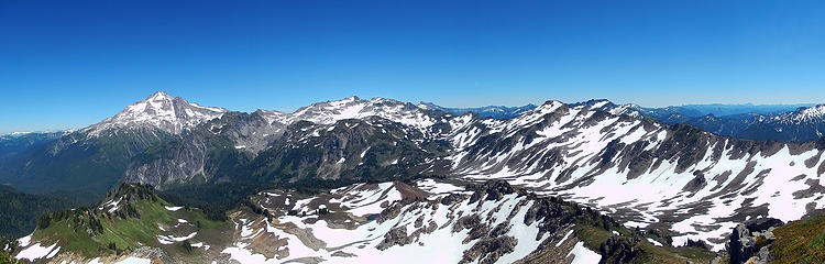
This is a big panorama from White Mountain. If you download it and zoom into the creek then you can see a bootpath there.
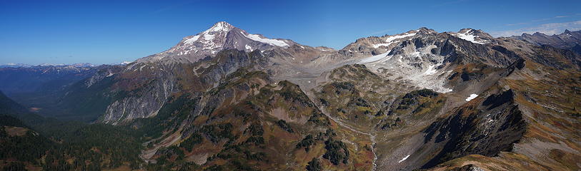 Glacier Peak and the White Chuck Glacier 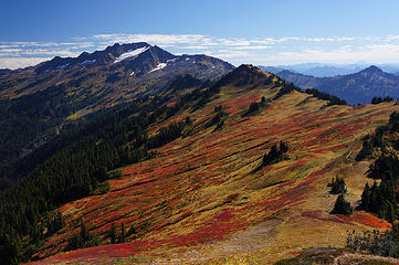 White Pass with Indian Head Peak in the background 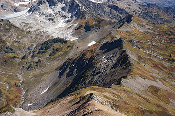 Foam ridge from White Mountain
|
| Back to top |
|
|
contour5
Member

Joined: 16 Jul 2003
Posts: 2963 | TRs | Pics
|
|
contour5
Member
|
Fri Aug 24, 2018 9:09 pm |
|
|
Easiest access would be N. Fork Sauk trail. White Pass to Red Pass, then down the PCT to intersect the drainage that leads up into the meadowy basin. Or you could go from White Pass to Foam Creek Pass and drop down to the lower basin. Actually, Foam Creek might be easier... you could make a superdiscombobulating micro-loop by going in one way and out the other!
A larger loop is possible by entering/exiting through Lost Creek Ridge or Pilot Ridge. These loops both add a relatively insignificant number of miles while providing twice the experiential cartographology, compared to a simple in-and-out.
 WC-Cinder-Cone
|
| Back to top |
|
|
olderthanIusedtobe
Member
Joined: 05 Sep 2011
Posts: 7709 | TRs | Pics
Location: Shoreline |
| contour5 wrote: | | asiest access would be N. Fork Sauk trail. White Pass to Red Pass, then down the PCT to intersect the drainage that leads up into the meadowy basin. Or you could go from White Pass to Foam Creek Pass and drop down to the lower basin. Actually, Foam Creek might be easier... you could make a superdiscombobulating micro-loop by going in one way and out the other! |
That's exactly what I did. Fun loop, I highly recommend.
|
| Back to top |
|
|
Exmoor
Member
Joined: 20 Mar 2013
Posts: 89 | TRs | Pics
Location: Snohomish |
|
Exmoor
Member
|
Fri Aug 24, 2018 11:26 pm |
|
|
| mbravenboer wrote: | This is a big panorama from White Mountain. If you download it and zoom into the creek then you can see a bootpath there.
Glacier Peak and the White Chuck Glacier |
This photo is both especially beautiful and extremely helpful to me since it gives me an idea of habitat and terrain down there. Thank you!
| contour5 wrote: | WC-Cinder-Cone |
This photo is very helpful as well.
It's been pretty difficult for me to pin down some of the topography around there. All the Google Earth images taken recently have been earlier in the year when everything is still covered in snow.
My main goals are Gray-Crowned Rosy-Finch, White-Tailed Ptarmigan, and Horned Lark. There's a few other species that are possible on the trip, but if I pick up all three of those I'll come home very happy. I'm doing what birders call a "big year" in Snohomish county this year, where I'm trying to see as many species of birds in the county as possible. For this reason the Sauk entrance makes the most sense, since it keeps me in the county except for the few miles of Foam Ridge where you cross into Chelan County. The east-west county borders pretty much explicitly follow the crest of the cascades and there are a number of species that are fairly common east of the crest, but are rarely, if ever, recorded west of it.
Beyond my own personal goals, this area has intrigued me for several years. Although it sees a ton of hiker and climber traffic, very few people that I'm aware of have ever entered this area with the priority of recording bird species and numbers seen there.
|
| Back to top |
|
|
olderthanIusedtobe
Member
Joined: 05 Sep 2011
Posts: 7709 | TRs | Pics
Location: Shoreline |
That sounds cool, good luck with your Big Year.
|
| Back to top |
|
|
Brushwork
Food truck
Joined: 18 Aug 2018
Posts: 508 | TRs | Pics
Location: Washington |
|
Brushwork
Food truck
|
Sat Aug 25, 2018 10:39 pm |
|
|
I don't know if this matters but for what it's worth... the area of White chuck glacier basin and adjacent "basin" to the south (while cool) has very few trees. In fact vegetation in general. A few trees on the ridges. But mostly rock.
The area nearer to Red Pass, including the low valley between RP & WCGB has much more vegetation. I would think those valleys would be worth checking for birds. A bunch of willow there.
Good luck!
When I grow up I wanna play.
When I grow up I wanna play.
|
| Back to top |
|
|
|
|


