| Previous :: Next Topic |
| Author |
Message |
rubywrangler
Member


Joined: 04 Aug 2015
Posts: 511 | TRs | Pics
|
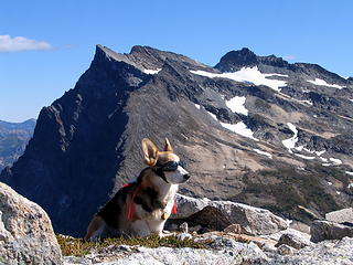
I had been wanting to visit L. creek basin in larch season since gazing upon it from the summit of Clark a couple years ago. But when the stars (ie weather, schedule, health) aligned this year, I had major anxiety about it for some reason. Maybe because the last time I dabbled in Routes and Rocks I ended up on crutches. Possibly because trip reports made the LC High Route sound horrendous and not doable for meanderers like Ruby and me in the limited daylight of October. Ruby's been slowing down this year and I was concerned it would be too much for her. I postponed the trip twice trying to scrounge up a partner, but everyone I know who would be up for a trip like this is either out of PTO or injured. So in the end I made a pretty detailed plan, with many options and contingencies, and went solo (plus dog). Well, it turns out my anxiety was a total waste of energy.
After spending a second night in Leavenworth instead of sleeping at the trailhead (bad decision - another hour of daylight would have been nice), Ruby and I set out from the LGP trailhead around 9:30am Friday. We reached the pass at 12:30 and LC falls at 4. I had figured that if we got to the base of the falls by 4, we could probably get to the top of the falls by sunset, IF we didn't have any routefinding issues. And if things started to go south by 5, we should turn around and head for the R&R red dot camp a bit further up the Napeequa valley. Fortunately we had minimal issues and were able to easily follow the route described by wolffie and Steve in some old posts on this site. We arrived the R&R red dot camp at 6400' at 6:10pm - almost exactly sunset.
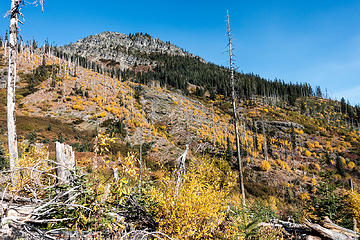 colors along the little giant trail 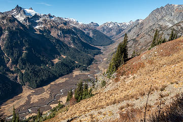 napeequa valley 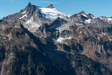 clark 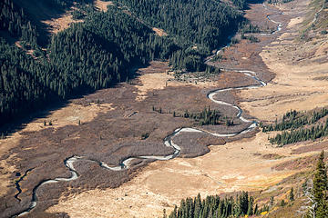 snakey napeequa 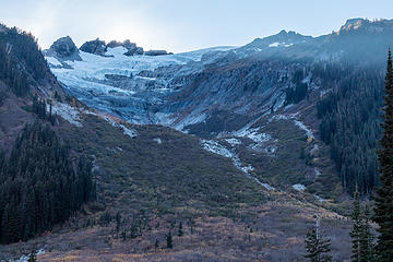 clark 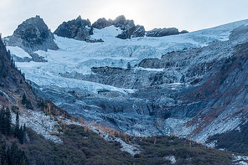 walrus glacier 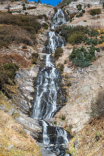 l. creek falls 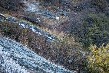 goats across the falls, climbed about 600-700 ft so far 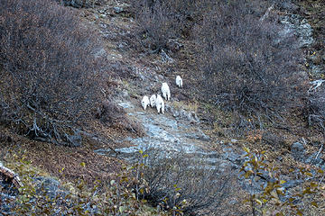 retreat! 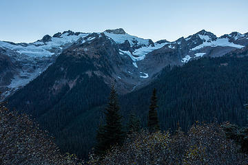 losing light, climbing higher 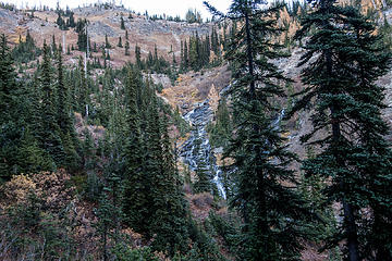 middle falls 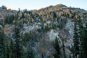 going up there somewhere 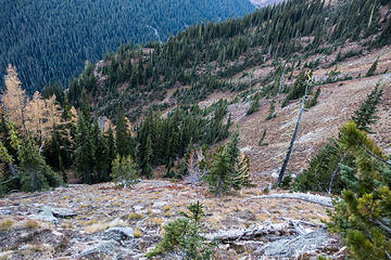 we came up climbers left and then around, a bit lower down 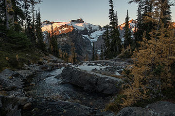 clark 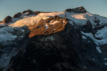 clark at sunrise 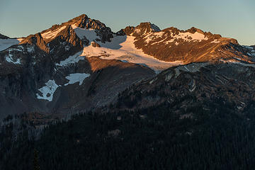 luahna 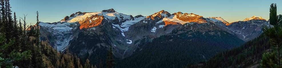 sunrise pano 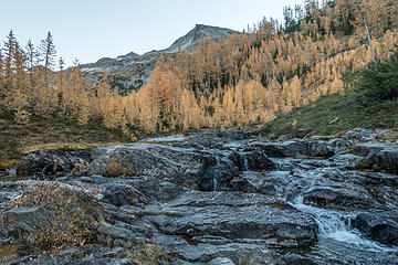 looking upstream into l. basin 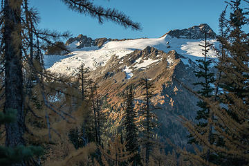 clark 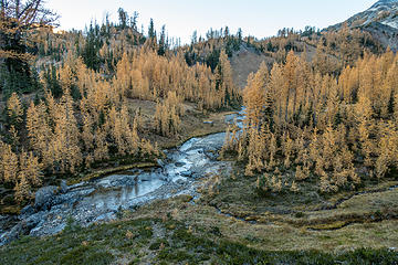 l creek 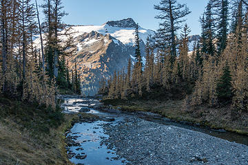 clark & creek 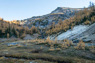 l. creek basin 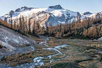 basin & clark 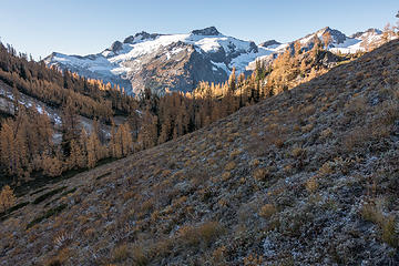 views on the way to the pumice plateau 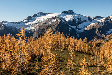 OMG 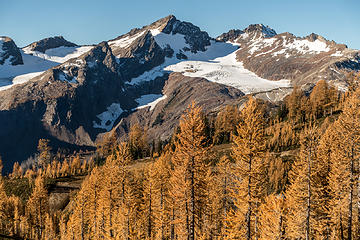 OMG2 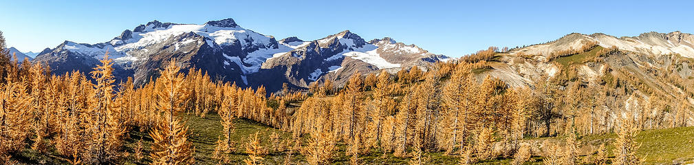 larchy pano 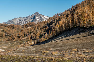 my nemesis 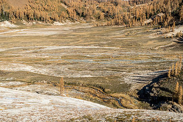 pumice 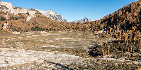 pumice plateau 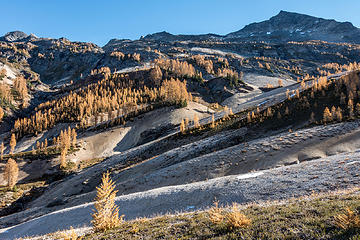 larches all around 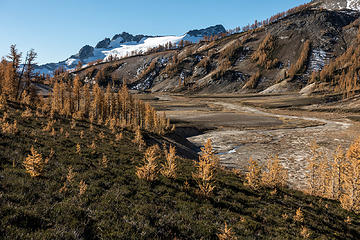 pumice, larches & clark 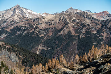 fortress, chiwawa, red 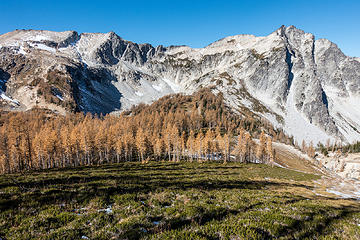 our route to high pass, for later 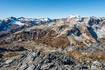 looking back on the pumice plateau 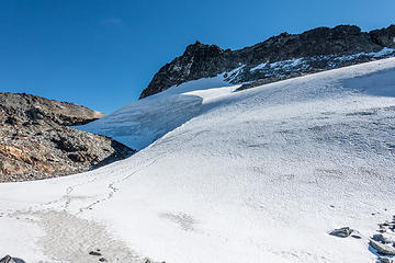 buck snowfield. footprints everywhere. 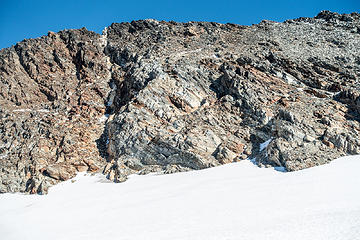 summit left of the white stripe 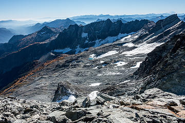 views west from the saddle 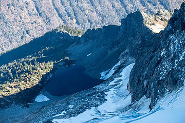 king lake 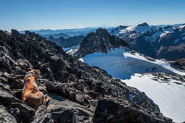 buck summit nap 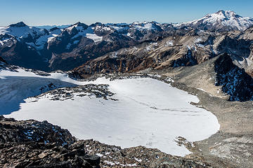 summit view east 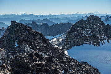 layers 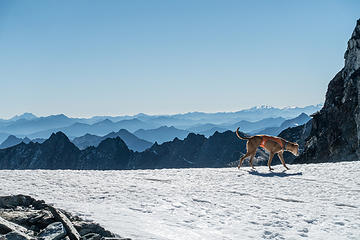 cooling paws 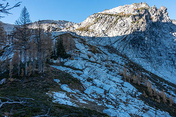 our route ahead 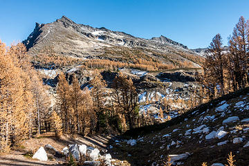 looking back at buck 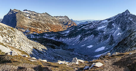 view just below berge saddle 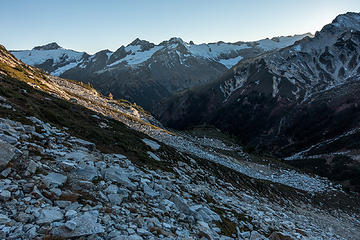 descending to high pass 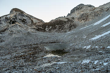 lake south of high pass 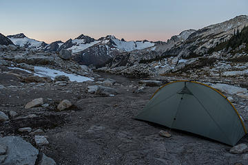 camp at sunrise 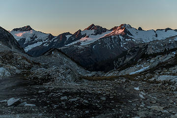 first light on clark & luahna 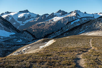 high pass 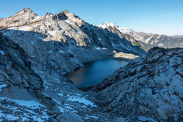 triad 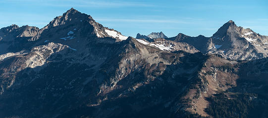 fortress and chiwawa - closer 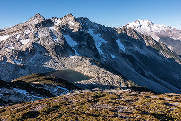 triad vicinity 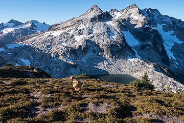 sitting nap 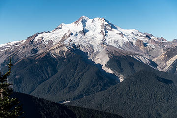 GP 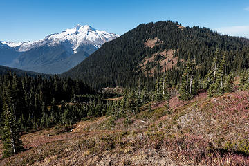 glacier peak and flower dome (not toasted) 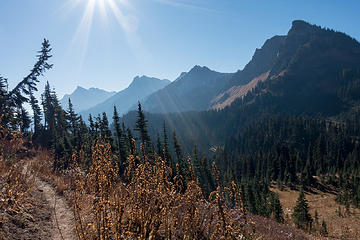 buck creek trail, buck in the distance
|
| Back to top |
  
|
|
awilsondc
Member

Joined: 03 Apr 2016
Posts: 1324 | TRs | Pics
|
|
| Back to top |
|
|
Jake Robinson
Member

Joined: 02 Aug 2016
Posts: 521 | TRs | Pics
|
Such a nice trip...that area is really special. Thanks for documenting it so well with your exceptional photos and writeup 
|
| Back to top |
|
|
RichP
Member

Joined: 13 Jul 2006
Posts: 5634 | TRs | Pics
Location: here |
|
RichP
Member
|
 Tue Oct 23, 2018 7:18 pm |
|
|
I enjoyed your report and photos.
|
| Back to top |
|
|
ozzy
The hard way

Joined: 30 Jul 2015
Posts: 476 | TRs | Pics
Location: University place, wa |
|
ozzy
The hard way
|
Tue Oct 23, 2018 7:40 pm |
|
|
| rubywrangler wrote: | view just below berge saddle |
Love that one of Buck! I went up to high pass about a month ago, awesome area. Unfortunately i was fighting a cold and bailed on Buck the next day.  Well put together tr and nice job to you and ruby! Cheers! Well put together tr and nice job to you and ruby! Cheers!
I dont know whats gonna happen, but I wanna have my kicks before the whole shithouse goes up in flames-Mr Mojo Risin
I dont know whats gonna happen, but I wanna have my kicks before the whole shithouse goes up in flames-Mr Mojo Risin
|
| Back to top |
|
|
Nancyann
Member
Joined: 28 Jul 2013
Posts: 2318 | TRs | Pics
Location: Sultan Basin |
|
Nancyann
Member
|
Tue Oct 23, 2018 10:11 pm |
|
|
So many stunning pictures, Im just going crazy over them!  Glad to hear Ruby could make the trip and handled it well!
|
| Back to top |
|
|
fourteen410
Member

Joined: 23 May 2008
Posts: 2629 | TRs | Pics
|
|
| Back to top |
|
|
timberghost
Member
Joined: 06 Dec 2011
Posts: 1330 | TRs | Pics
|
|
| Back to top |
|
|
DaddyJoe
Member
|
|
DaddyJoe
Member
|
Wed Oct 24, 2018 8:27 am |
|
|
Awesome post. I guess I should have just stopped looking on here for TR's and actually started posting as it would have been good to have a partner on this same trip only last weekend, always safer.
I ended up going up the west shoulder of cleator approach, 10/14-10/15 to the buck Berge basin, That was my only goal to get up there and see the larches as my wife only gave me 2 days away from kids. I updated that route on summit post corrections, but may post it here eventually as well, it's probably the quickest... made it up in 5 hrs to the basin from trinity, although I was not taking my time, and basically bonking by the time I got to the basin. The Burn area along Buck creek has made that approach easier for now. Although in a few years the schwack up there will be miserable as the underbrush begins to grow in.
I especially enjoyed the pictures of the lower basin as I didn't explore down there and yes the sun doesn't come up until like 11! OH, well Glad someone else got to see it! and one of the most beautiful areas in the state! Here's to missed opportunities.
|
| Back to top |
|
|
geyer
Member

Joined: 23 May 2017
Posts: 463 | TRs | Pics
Location: Seattle |
|
geyer
Member
|
Wed Oct 24, 2018 9:16 am |
|
|
| rubywrangler wrote: | clark & creek |
That's a nice picture you have there  But seriously
  I love this place. It's one of those places I'd want to go back to year after year, and I never feel that way. So good I love this place. It's one of those places I'd want to go back to year after year, and I never feel that way. So good
|
| Back to top |
|
|
rubywrangler
Member
Joined: 04 Aug 2015
Posts: 511 | TRs | Pics
|
Thanks all for the comments! It's a pretty awesome place. As a general rule I don't do repeat trips, ever, but I will do this one again. With one more day you could add on the Massie HR and see the larches at Massie lake...
| geyer wrote: | | That's a nice picture you have there |
I tried to get Ruby to pose for a glamour shot, but she would't cooperate. 
|
| Back to top |
|
|
Snowdog
Member

Joined: 21 Jul 2006
Posts: 1028 | TRs | Pics
Location: on (& off) the beaten path |
|
Snowdog
Member
|
Wed Oct 24, 2018 9:59 am |
|
|
Very nice! I've been to LGP, and up Buck Creek to the pass and on to High Pass. Just need to fill in that missing section.
'we don't have time for a shortcut'
'we don't have time for a shortcut'
|
| Back to top |
|
|
MtnGoat
Member

Joined: 17 Dec 2001
Posts: 11992 | TRs | Pics
Location: Lyle, WA |
|
MtnGoat
Member
|
Wed Oct 24, 2018 12:22 pm |
|
|
Magnificent. Thank you
Diplomacy is the art of saying 'Nice doggie' until you can find a rock. - Will Rogers
Diplomacy is the art of saying 'Nice doggie' until you can find a rock. - Will Rogers
|
| Back to top |
|
|
wolffie
Member

Joined: 14 Jul 2008
Posts: 2693 | TRs | Pics
Location: Seattle |
|
wolffie
Member
|
Thu Oct 25, 2018 10:35 am |
|
|
| rubywrangler wrote: | | I tried to get Ruby to pose for a glamour shot |
I got some of my best corgi pics up there (both Al and Gwynnie), including them posing at, of all places, Little Giant Pass.
 Buck Mt. in background; after Gwynnie showed the way, Al climbed it some years later. 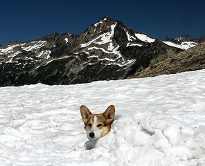 Nothing like a pupsicle on a hot day. 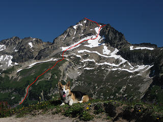 Gwynnie's masterpiece; standard route on Fortress Mt. 8750. 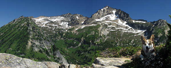 Fortress Mt. from near Liberty Cap. 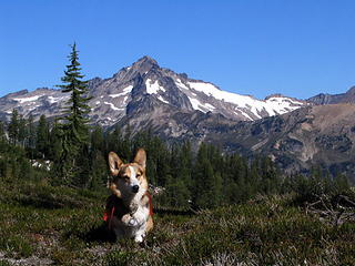 View of Fortress Mt. from the col between Buck and Berge; Louis Creek High Route. 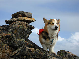 Near the summit of Fortress Mt.  324. Fortress_summit2
Some people have better things to do with their lives than walking the dog. Some don't.
Some people have better things to do with their lives than walking the dog. Some don't.
|
| Back to top |
|
|
Brushbuffalo
Member

Joined: 17 Sep 2015
Posts: 1887 | TRs | Pics
Location: there earlier, here now, somewhere later... Bellingham in between |
Wonderful!
| rubywrangler wrote: | | As a general rule I don't do repeat trips, |
Maybe one of these years I'll learn not to repeat the same trips over and over. 
Passing rocks and trees like they were standing still
Passing rocks and trees like they were standing still
|
| Back to top |
|
|
|
|


