| Previous :: Next Topic |
| Author |
Message |
talapus
Member


Joined: 17 Aug 2012
Posts: 68 | TRs | Pics
|
|
talapus
Member
|
 Mon Jul 02, 2018 2:44 pm |
|
|
Planning on doing it (from West Foss to Necklace Valley, over 3 days) on 7/13, for the first time. Has anyone been up there lately? How is the snow looking? Any advice on the safer routes for the conditions, up to and including GPX tracks?
Thanks in advance!
|
| Back to top |
  
|
|
wolffie
Member

Joined: 14 Jul 2008
Posts: 2693 | TRs | Pics
Location: Seattle |
|
wolffie
Member
|
Mon Jul 02, 2018 4:48 pm |
|
|
not lately, but done it a coupla times.
From Chetwoot Lake, go due E until cliffs force you NNE to a 5500' bench, nice campsite.
If time and you want to camp high, you can go way up on Iron Cap -- summit not to be missed if good weather -- usually a snow patch even in later season.
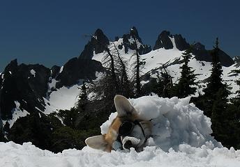 Al chilling out on the summit. 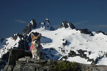 Al monitors the universe 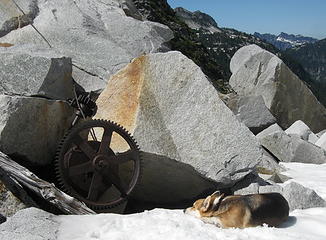 Winch at LaBohn Gap, 2013. 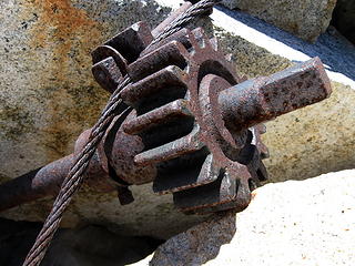 Winch at LaBohn Gap, 2013. 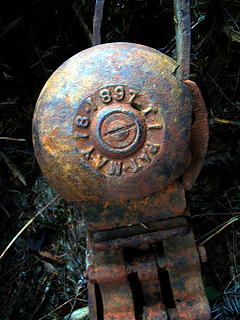 Tram hanger detail 2008. The circular object is a bell. Note the date. 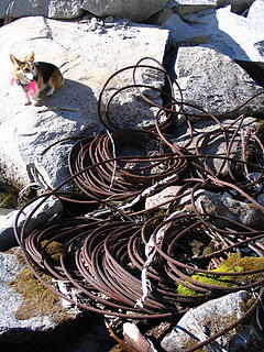 LBG0129.MiningCable 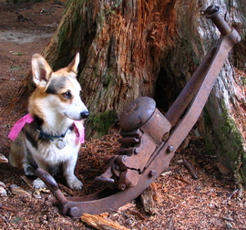 LBG0012.TramTrolleyNTR 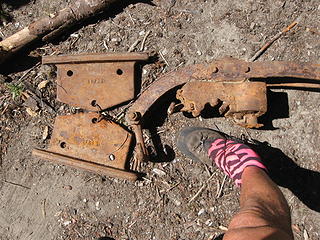 Tram hanger. Note that the paired plates are wired together, presumably unused. They may have mounted the paired wheels. Not sure. This tram had a stationary suspension cable and a moving hauling cable, not like a chair lift.
Some people have better things to do with their lives than walking the dog. Some don't.
Some people have better things to do with their lives than walking the dog. Some don't.
|
| Back to top |
|
|
DIYSteve
seeking hygge

Joined: 06 Mar 2007
Posts: 12655 | TRs | Pics
Location: here now |
|
DIYSteve
seeking hygge
|
Mon Jul 02, 2018 7:31 pm |
|
|
I've done the ALHR, Beckey classic or several variant (some Beckey) 5 times. I can provide general info re route, although not re current conditions.
FWIW, the ALHR in Beckey's book goes (E to W) from Iron Cap Gap to Azurite Lake via a lower route. Per Beckey, going high around Iron Cap Peak is a variant. I prefer the latter. There are two alternatives re getting around the steep part, one at est. 5640'-5640', the other starts the same then ascends solid rock to est. 5900'.
3 days is quite ambitious for the entire classic ALHR from Necklace Valley to Lake Dorothy.
|
| Back to top |
|
|
Sculpin
Member

Joined: 23 Apr 2015
Posts: 1383 | TRs | Pics
|
|
Sculpin
Member
|
Tue Jul 03, 2018 8:06 am |
|
|
| DIYSteve wrote: | | Iron Cap Gap to Azurite Lake via a lower route |
This might very well be preferable in early season. We encountered little difficulty (or brush) between Azurite and the gap on a more or less direct line. It is a bit rough getting around the shore of Azurite though.
Between every two pines is a doorway to the new world. - John Muir
Between every two pines is a doorway to the new world. - John Muir
|
| Back to top |
|
|
DIYSteve
seeking hygge
Joined: 06 Mar 2007
Posts: 12655 | TRs | Pics
Location: here now |
|
DIYSteve
seeking hygge
|
Tue Jul 03, 2018 9:04 am |
|
|
| Sculpin wrote: | | It is a bit rough getting around the shore of Azurite though. |
Getting around the S side is not a problem if you stay on route and find Beckey's key ledge.
|
| Back to top |
|
|
joker
seeker

Joined: 12 Aug 2006
Posts: 7953 | TRs | Pics
Location: state of confusion |
|
joker
seeker
|
Tue Jul 03, 2018 11:26 am |
|
|
Yeah, if you find that ledge and otherwise follow the route properly it goes pretty well - I though the biggest challenge, per the "duff spikes" thread, was some hard slick duff both on the approach to that ledge (coming from the west) and then some more and worse duff crossed on the descending traverse away from Azurite's outlet. Nothing a little attention wasn't able to manage, but I appreciated my trekking poles there!!
We did a dayhike and sorta scouting from Chetwoot -> Iron Cap Lake and thereabouts and my impression was that this involved quite a bit of boulder field walking where the angle of repose of the boulders required more faith than usual. We didn't find the crossing from there to the pass to the east through the cliffs in a modest bit of wandering - at least not one that we felt comfortable with for carrying the multi-day packs. But then we had Beckey's description and not Steve's beta  Also, when we looked back at this from near that pass to the east of Iron Cap, it looked like if we had managed to get around the cliffs at that mid zone we'd have bought into a fair bit of talus traversing. I really enjoyed the walking up the drainage bottom above Otter, at least once we got past the brushy maze (and even that was pretty OK) and into solid woods and then subalpine and alpine meadows. Glorious terrain. Also, when we looked back at this from near that pass to the east of Iron Cap, it looked like if we had managed to get around the cliffs at that mid zone we'd have bought into a fair bit of talus traversing. I really enjoyed the walking up the drainage bottom above Otter, at least once we got past the brushy maze (and even that was pretty OK) and into solid woods and then subalpine and alpine meadows. Glorious terrain.
|
| Back to top |
|
|
talapus
Member
Joined: 17 Aug 2012
Posts: 68 | TRs | Pics
|
|
talapus
Member
|
Wed Jul 04, 2018 1:49 pm |
|
|
Thanks so much for the help, folks!
As I look at the map trying to prepare, I am having difficulty converting your directions to a path I would follow, presumably since I am insufficiently adept at this.
I know of two lines (above). The red one goes E from Chetwwoot, but fails to turn NNE at the cliffs. And the Black one just makes a beeline for Azure and Azurite.
Any help in drawing the lines you are describing? E.g., where is the famous Beckey key bench or the knob at 5500'?
Normally, I would plunge into this vaguely with a sense of adventure, but this seems challenging enough that I'd prefer to have a clue.
Thanks in advance!
Edit: I *think* you are describing the Blue line. Am I correct? Is this the higher or the lower one?
|
| Back to top |
|
|
Sculpin
Member
Joined: 23 Apr 2015
Posts: 1383 | TRs | Pics
|
|
Sculpin
Member
|
Wed Jul 04, 2018 2:23 pm |
|
|
Talapus,
My group took the black route. It was a long time ago now, but I do not remember any steep spots or heavy brush, nor do I remember much annoying sidehilling.
We did not know about Beckey's "key ledge" or whatever to get around Azurite but I do remember carefully picking our way. Since I won't do anything above Class 3 it can't be too bad!
Between every two pines is a doorway to the new world. - John Muir
Between every two pines is a doorway to the new world. - John Muir
|
| Back to top |
|
|
Waterman
Member
Joined: 21 Mar 2015
Posts: 589 | TRs | Pics
Location: Big Snow Quadrangle |
|
Waterman
Member
|
Wed Jul 04, 2018 5:26 pm |
|
|
You shouldn't have any trouble at all going the lower route. The ledge that you follow on down to Azurite is easy to find and follow.
DIY Steve is right that 3 days is ambitious. Try to take a little more time if possible.
Two roads diverged in a wood, and I,I took the one less traveled by. And that has made all the difference.
Robert Frost
Two roads diverged in a wood, and I,I took the one less traveled by. And that has made all the difference.
Robert Frost
|
| Back to top |
|
|
DIYSteve
seeking hygge
Joined: 06 Mar 2007
Posts: 12655 | TRs | Pics
Location: here now |
|
DIYSteve
seeking hygge
|
Wed Jul 04, 2018 5:51 pm |
|
|
See Beckey's schematic map re classic ALHR (lower route) and higher variants. Don't get too married to a route on a map. ALHR requires both navigation and routefinding skills.
We encountered quite a bit of blowdown at est. 500m SE of Azurite outlet on the lower route 2 years ago. I don't recall encountering that much blowdown on prior trips. There are a few unpleasant brushy stretches on the lower route.
|
| Back to top |
|
|
joker
seeker
Joined: 12 Aug 2006
Posts: 7953 | TRs | Pics
Location: state of confusion |
|
joker
seeker
|
Wed Jul 04, 2018 9:09 pm |
|
|
| DIYSteve wrote: | | See Beckey's schematic map re classic ALHR (lower route) and higher variants. Don't get too married to a route on a map. ALHR requires both navigation and routefinding skills. |

|
| Back to top |
|
|
talapus
Member
Joined: 17 Aug 2012
Posts: 68 | TRs | Pics
|
|
talapus
Member
|
Thu Jul 05, 2018 8:40 am |
|
|
Thanks all! Will heed advice.
|
| Back to top |
|
|
Schroder
Member

Joined: 26 Oct 2007
Posts: 6719 | TRs | Pics
Location: on the beach |
|
Schroder
Member
|
Thu Jul 05, 2018 10:25 am |
|
|
I traversed on a fairly level contour from Iron Cap Lake with maybe 150 ft variation up and down when it was snow-free.
|
| Back to top |
|
|
DIYSteve
seeking hygge
Joined: 06 Mar 2007
Posts: 12655 | TRs | Pics
Location: here now |
|
DIYSteve
seeking hygge
|
Thu Jul 05, 2018 5:02 pm |
|
|
| Schroder wrote: | | I traversed on a fairly level contour from Iron Cap Lake with maybe 150 ft variation up and down when it was snow-free. |
That's the one I describe @ est. 5640'-5640'. The alternative is to start the same (if going E to W), then ascend on a ridge trending SW on solid rock to est. 5900', then down moderately easy terrain to Iron Cap Lake. The choice can be distilled to whether you go below or above the cliff c. 500m directly N or Iron Cap summit. The general idea of both routes are pretty obvious on the map. The latter makes sense if you plan to tag Iron Cap summit, dropping packs at 5900'.
|
| Back to top |
|
|
Bedivere
Why Do Witches Burn?

Joined: 25 Jul 2008
Posts: 7464 | TRs | Pics
Location: The Hermitage |
|
Bedivere
Why Do Witches Burn?
|
Sat Jul 07, 2018 6:09 pm |
|
|
Have done the route indicated on this map several times. NBD getting around Azurite but becomes brushy descending the slope from Azurite's outlet until you reach the sloping boulder field in the broad gully that dumps down into Otter. Crossing the boulders is easy enough and the narrow gully leading up to the plateau at ~4400' is easy going. The plateau itself is actually a marshy pond and pretty much impossible to get around without getting your feet wet. It becomes quite brushy again as you cross the rocky gully to the SE of the plateau but once you get around the ridgeline and into the narrow valley containing Otter's inlet stream the going gets easy again. Really neat area.
|
| Back to top |
|
|
|
|


